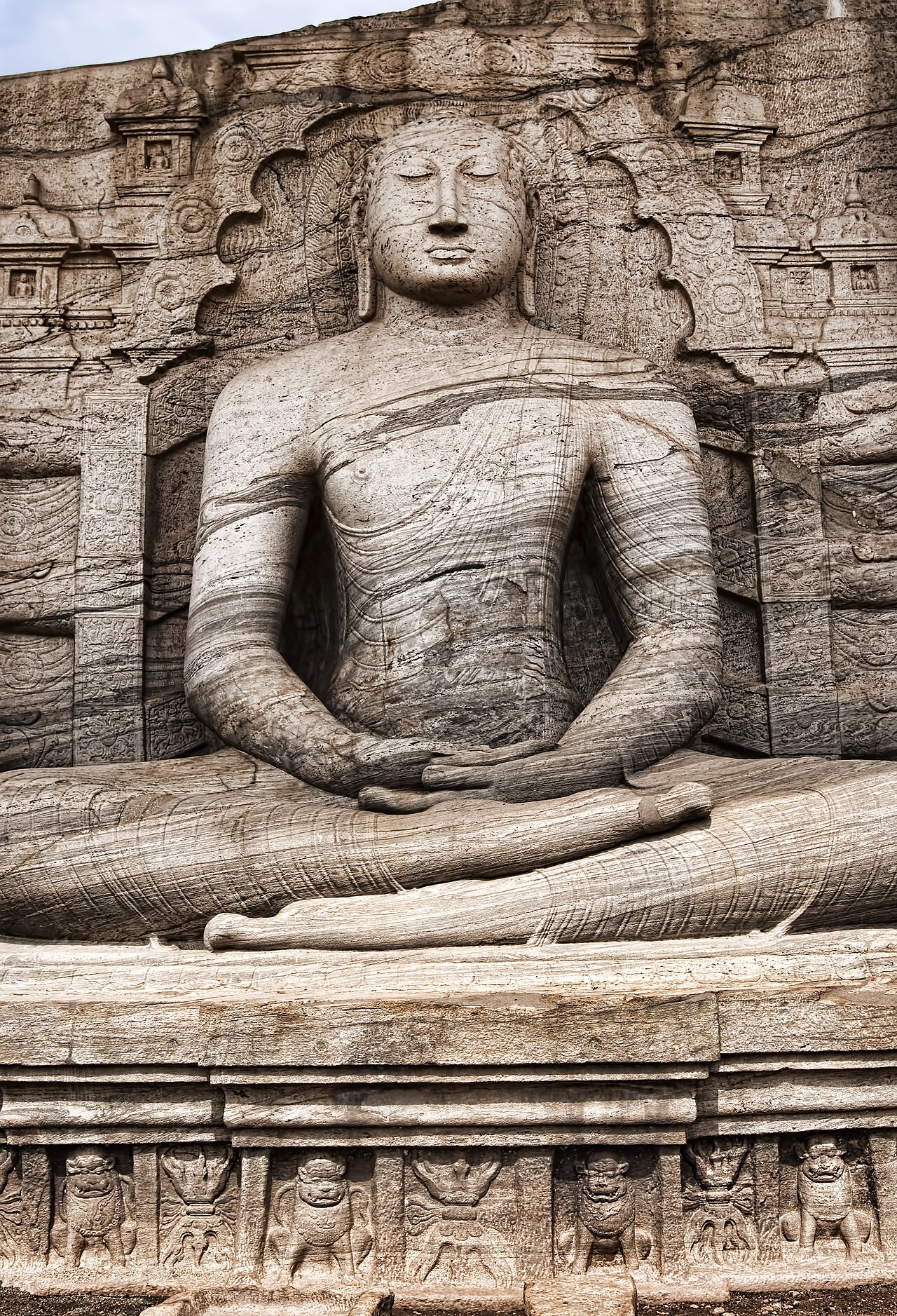
Polonnaruwa served as the second capital of Sri Lanka from 1017 to 1215 CE and contains the most complete surviving medieval city on the island. Under King Parakramabahu I, who reigned from 1153 to 1186 CE, the city’s builders carved four colossal Buddha figures from a single face of granite and engineered a reservoir covering 22 square kilometres that remains in agricultural use today. The city was abandoned after a South Indian invasion in 1215 CE and the subsequent collapse of the dry-zone irrigation network, and two more UNESCO World Heritage Sites lie within 100 kilometres.
Polonnaruwa: The Medieval Capital and Its Monuments City centre — on-site
Polonnaruwa received UNESCO World Heritage status in 1982, the same year as Anuradhapura, the city it supplanted as capital. The Chola dynasty of South India sacked Anuradhapura in 1017 CE, and the subsequent Sri Lankan kings — first under Chola governance, then under the re-established Sinhalese polity from 1055 CE — administered the island from Polonnaruwa. The city reached its political and architectural apex under King Parakramabahu I (r. 1153–1186 CE), who is credited in the Culavamsa — the later continuation of the Mahavamsa chronicle — with consolidating or constructing approximately 12,000 irrigation tanks across the dry zone of northern Sri Lanka.
The city was abandoned in 1215 CE following the invasion of Magha, a South Indian ruler who held Polonnaruwa for 21 years and whose forces destroyed many of the irrigation works. Without maintenance, the dry-zone tanks silted and breached, the agricultural base collapsed, and malaria spread through the stagnant water bodies. The population moved southward and westward into wetter zones where agriculture was less dependent on managed irrigation. Polonnaruwa remained largely uninhabited for several centuries, which inadvertently preserved many of its medieval structures beneath encroaching jungle.
Gal Vihara is the site’s most significant monument: a 12th-century rock temple in which four Buddhist images were carved directly into a single continuous face of granite during the reign of Parakramabahu I. The composition, reading from left to right, comprises a smaller seated Buddha (1.5 metres), a larger seated Buddha (4.6 metres) seated in the dhyana (meditation) mudra inside a carved shrine chamber, a standing figure (7 metres) with arms crossed in an unusual posture — identified by some scholars as the monk Ananda rather than the Buddha — and a reclining figure (14 metres) in the parinirvana position. The reclining and standing figures are the largest carved-stone Buddhist images on the island. The carved shrine around the seated 4.6-metre figure retains traces of painted decoration, and the rock surface above preserves the outlines of a former timber roof structure built to protect the carvings.
The Rankoth Vihara stupa, built by King Nissanka Malla (r. 1187–1196 CE), stands 55 metres tall and ranks as the fourth largest stupa in Sri Lanka. Nissanka Malla was Parakramabahu I’s successor and a prolific builder of inscriptions — more inscribed stone slabs survive from his reign than from any other Polonnaruwa king. Several of these inscription stones, still visible at the site, record his building projects and his claim to have united Sri Lanka. The stupa’s spire is gilded, and the surrounding platform, enclosed by a brick wall, contains smaller subsidiary shrines.
The Parakrama Samudra — the Sea of Parakrama — is a reservoir constructed or greatly expanded under Parakramabahu I, covering 22 square kilometres and holding approximately 135 million cubic metres of water at capacity. The bund (earthen dam) enclosing it stretches for 14 kilometres. It remains in operational use for rice agriculture in the surrounding district and is visible from the main archaeological circuit. Ancient texts record Parakramabahu I as declaring that “not one drop of water received from rain should be allowed to flow into the sea without being made useful to man” — an injunction that resulted in the most ambitious hydraulic engineering programme in pre-modern South Asia outside of Cambodia’s Khmer reservoir systems.
Anuradhapura and Sigiriya 100 km northwest and 60 km northwest by road
Anuradhapura lies approximately 100 kilometres northwest of Polonnaruwa along the A11 highway, a drive of roughly two hours on good road. It predates Polonnaruwa by over a thousand years: its documented history as a capital begins in 380 BCE, making it one of the longest continuously inhabited cities in the ancient world. The UNESCO inscription covers ten monuments within its sacred precinct, ranging from the Thuparama Dagoba (3rd century BCE) — the earliest surviving dagoba in Sri Lanka, built to enshrine the right collar bone of the Buddha — to the Jetavanaramaya (3rd century CE), which at its original height of 122 metres was the third tallest structure in the ancient world.
The Sri Maha Bodhi at Anuradhapura, a living tree planted in 288 BCE from a cutting of the Bodhi tree at Bodh Gaya, is the oldest historically documented tree in the world. Buddhist chronicles record that Princess Sanghamitta carried the sapling to Sri Lanka at the invitation of King Devanampiya Tissa; it has been under monastic care for over 2,300 years. The original Bodhi tree at Bodh Gaya was destroyed in the 7th century CE, making the Anuradhapura specimen the oldest surviving representative of the line. Visitors to Polonnaruwa intending to also visit Anuradhapura can do so as a half-day extension, with the main sacred precinct’s monuments accessible on bicycle.
Sigiriya lies approximately 60 kilometres northwest of Polonnaruwa on the A11 and B294 roads, a drive of about 90 minutes. King Kashyapa I (r. 477–495 CE) built his palace on the summit of the 200-metre granite inselberg after seizing the throne by killing his father, King Dhatusena. The palace complex, hydraulic gardens, and the famous frescoes on the cliff face all date to this brief eighteen-year occupation. When Kashyapa’s half-brother Moggallana returned from exile in India to reclaim the throne, Kashyapa descended from the rock to meet him in battle and was defeated; he died in 495 CE. Moggallana then moved the capital back to Anuradhapura, and Sigiriya reverted to use as a Buddhist monastery. The site’s water gardens — covering 40,000 square metres at the base of the rock — include gravity-fed fountains that still flow during the rainy season, the only ancient fountain system in Asia still operational.
Practical information
Polonnaruwa is best visited between December and April, when the North Central Province’s dry season brings minimal rainfall and cooler mornings. Average temperatures range from 26 to 34°C year-round, with the dry season months offering the most comfortable conditions for walking the extensive outdoor archaeological circuit, which covers several kilometres on foot or by bicycle. Bicycle rental is available near the UNESCO site entrance; the ride between the main monuments (Gal Vihara, the Rankoth Vihara, the Alahana Parivena complex, and the Royal Palace) takes approximately two to three hours at a leisurely pace.
The nearest international gateway is Bandaranaike International Airport (CMB) at Colombo, approximately 220 kilometres southwest; the journey by road takes four to five hours via the A6 highway. Intercity bus services run from Colombo Central Bus Station to Polonnaruwa town, and the Colombo–Batticaloa railway line stops at Gal Oya junction, from which local buses reach Polonnaruwa. The Cultural Triangle Round Ticket, issued by the Central Cultural Fund, covers entry to Polonnaruwa, Anuradhapura, Sigiriya, Dambulla, and Kandy at a combined price lower than individual site fees. Sri Lanka’s Electronic Travel Authorisation (ETA) visa is available online before arrival for most nationalities, priced at USD 20 for a 30-day single-entry permit. The currency is the Sri Lankan Rupee (LKR), and ATMs are available in Polonnaruwa town. Modest dress — covered shoulders and knees — is required at all active Buddhist sites.
Frequently Asked Questions
What exactly was King Parakramabahu I’s irrigation achievement, and why was it lost?
Parakramabahu I (r. 1153–1186 CE) is credited in the Culavamsa with constructing or restoring approximately 12,000 irrigation tanks, 3,910 canals, 2,376 sluices, and 447 other water-management structures across the dry zone of northern Sri Lanka. These figures come from inscriptions of the period and from the chronicle, which was written with clear intent to glorify the king, so the precise numbers are not independently verified. What is not in dispute is that Sri Lanka’s ancient dry-zone civilisation depended entirely on a managed network of cascading tanks — small and medium reservoirs linked so that overflow from one fed the next — to supply rice agriculture during the long dry season. The system required constant maintenance: annual de-silting, repair of bunds after monsoon floods, and coordinated management across the full catchment. When Magha’s invasion in 1215 CE disrupted the state administration and triggered a prolonged period of political instability, the labour force that had maintained the tanks dispersed. Tanks breached, channels silted, and within a century or two the dry zone’s agricultural carrying capacity collapsed. The Parakrama Samudra itself — the great reservoir at Polonnaruwa — was eventually restored and is still operational, covering 22 square kilometres and serving as the largest single water body in the ancient city landscape.
Are the figures at Gal Vihara definitely the Buddha, or is the standing figure someone else?
The identity of the 7-metre standing figure at Gal Vihara has been debated among scholars since the 19th century. The figure’s arms are crossed at the chest — a posture not attested in canonical Buddhist iconographic traditions for the Buddha, who is typically depicted in one of several standardised mudras (hand positions). One school of interpretation holds that the posture indicates grief and that the figure therefore represents the monk Ananda, the Buddha’s personal attendant, lamenting the death of his teacher whose parinirvana is depicted in the adjacent reclining figure. This reading was put forward by the archaeologist Senarat Paranavitana and has been influential in Sri Lankan scholarship. A second school argues that the crossed-arm posture is simply a regional variation within medieval Sri Lankan Buddhist iconography, and that the figure is the Buddha in the samadhi (deep meditation) posture associated with the moment of death. There is no dedicatory inscription at Gal Vihara that identifies the figures by name, so the debate cannot be resolved from epigraphic evidence alone. The Sri Lankan Department of Archaeology identifies all four figures as the Buddha. Most visitors and most international guides follow the Department’s identification; the Ananda interpretation is the minority scholarly view, though it is cited in the standard academic literature on Polonnaruwa.
How much time does it take to see Polonnaruwa properly, and can it be combined with Sigiriya in one day?
A thorough visit to the Polonnaruwa archaeological complex — covering the Royal Palace, Quadrangle (Dalada Maluwa), Rankoth Vihara, Lankatilaka, Kiri Vehera, Gal Vihara, and the Tivanka Pilimage — requires a minimum of three to four hours, plus time at the site museum, which provides essential context and displays recovered artefacts including the famous bronze statues of Parakramabahu I. Cycling between the monuments is faster than walking but the distances involved still require most of the morning. Combining Polonnaruwa and Sigiriya in a single day is feasible in terms of driving distance — approximately 60 kilometres separate the two sites — but leaves limited time at each if you attempt both in an afternoon. The more practical itinerary is to spend the morning at Polonnaruwa (arriving at opening, around 07:00), drive to Sigiriya after lunch, and climb the rock in the late afternoon, arriving at the summit in time for the lower-angle light. The climb from base to summit takes 45 to 75 minutes depending on fitness, and the queue at the lion’s paw platform can add waiting time during peak season (December to March). Accommodation is available near both sites; the area between them, around Habarana, has a range of options from basic guesthouses to mid-range lodges.