Kilwa Kisiwani, a small island off the southern Tanzanian coast, was the commercial capital of the medieval Indian Ocean gold trade for approximately four centuries, controlling the flow of gold from the Zimbabwe Plateau to Arabia, India, and China. Ibn Battuta visited in 1331 and described the city as “one of the most beautiful and well-constructed towns in the world.” The ruins of Kilwa Kisiwani and the nearby island of Songo Mnara have been a UNESCO World Heritage Site since 1981.
The gold trade capital: how Kilwa Kisiwani controlled the Indian Ocean economy Southern Tanzanian coast, Indian Ocean
Kilwa Kisiwani sits on an island separated from the Tanzanian mainland by a narrow channel, roughly 300 kilometres south of Dar es Salaam. Its geographic position was the foundation of its medieval power. Gold mined on the Zimbabwe Plateau moved east through the Shona trading network to the Swahili coastal port of Sofala, in what is now central Mozambique. From Sofala, Arab and Swahili dhow merchants brought the gold north along the coast to Kilwa, which by the 13th century had established itself as the primary entrepôt for this trade. Ships carrying cotton, ceramics, and glass beads from Arabia, India, and China called at Kilwa; they left with gold, ivory, and iron. The gold ultimately fuelled the economies of the medieval Islamic world and reached as far as Song-dynasty China.
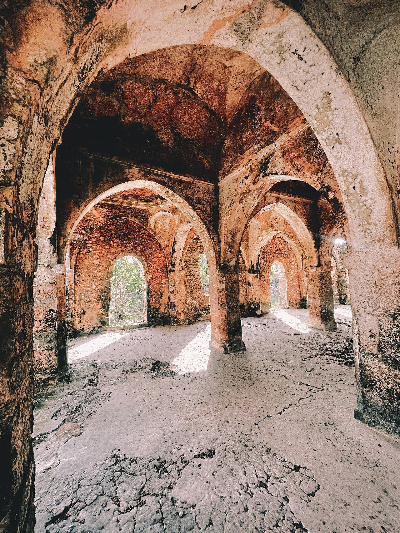
The prosperity generated by this trade is still visible in the ruins. The Great Mosque of Kilwa Kisiwani is the largest medieval coral mosque in East Africa. Its oldest sections date to the 11th century, making it among the earliest mosques in sub-Saharan Africa. In the 14th century the prayer hall was substantially expanded: a 16-bay vaulted ceiling was added, its roof carried on coral-stone columns quarried from the surrounding reef. The portico, known as the liwan, has eighteen barrel-vaulted bays running parallel to the qibla wall. The entire structure is cut coral limestone — a material cheap and abundant on the island, easy to carve when freshly quarried, and hardening over time into a substance of considerable strength. Walking through the mosque today, the scale of the 14th-century expansion communicates directly the wealth that had accumulated at Kilwa by that point.
The Husuni Kubwa palace, built around 1310 to 1333 CE under Sultan Abu al-Mawahib al-Husuni, is the largest pre-colonial building in sub-Saharan Africa. It contains approximately 100 rooms arranged around a sequence of courts, an octagonal bathing pool — a feature with no parallel elsewhere in East Africa at the time — and a large audience court where the sultan conducted state business. When officers of Portuguese explorer Pedro Álvares Cabral arrived at Kilwa in 1500, they recorded their astonishment at its sophistication; they were looking at a structure nearly two centuries old. The palace is less well preserved than the mosque, but its spatial organisation remains decipherable, and the octagonal pool survives in outline.
Ibn Battuta’s account, written after his visit in 1331, describes a city of well-built stone houses, extensive charitable giving by the sultan, and a regular practice of slave raiding into the African interior — a reminder that the prosperity of the Indian Ocean trade system was built on exploitation as well as exchange. The sultan he met, Abu al-Mawahib, was the same ruler under whom Husuni Kubwa was completed.
The Portuguese disruption and the long decline Portuguese arrival 1505; Omani period from 1698
The Indian Ocean trade system that sustained Kilwa for four centuries began to change decisively when Portuguese fleets reached the East African coast at the turn of the 16th century. Vasco da Gama called at Kilwa in 1498 on his voyage to India. In 1505, Francisco de Almeida — the first Portuguese Viceroy of India — arrived with a fleet, demanded submission from the sultan, was refused, and sacked the city. Portuguese forces occupied Kilwa and constructed Fort Gereza, whose walls, incorporating material from earlier structures, still stand near the shore. The strategic goal was to interpose Portuguese naval power into the Indian Ocean gold trade and divert its profits to Lisbon rather than to the Swahili city-states and the merchants of Gujarat and Arabia.
The Portuguese occupation was not permanent — they abandoned the fort in 1512, finding Kilwa’s trade too diminished and too difficult to control from a small garrison — but the damage to Kilwa’s commercial position was lasting. The gold trade route was progressively disrupted and redirected through Portuguese-controlled ports. Kilwa never recovered its position as the pre-eminent entrepôt of the East African coast. The city continued to function, and the mosque continued to serve its congregation, but the extraordinary wealth of the 14th and early 15th centuries did not return.
Omani Arab forces expelled the Portuguese from the East African coast by 1698, taking control of the principal ports including Mombasa and, later, Kilwa. Under Omani suzerainty Kilwa experienced a modest revival in the 18th century, this time based primarily on the slave trade rather than gold; Kilwa became a major point of export for enslaved people from the interior, with French slave traders from Île de France (Mauritius) among the key buyers. The 19th-century abolition movement gradually closed this trade, and by the time German colonial forces arrived in the 1880s, Kilwa was a small settlement on an island with large ruins.
Songo Mnara, a smaller island approximately 8 kilometres south of Kilwa Kisiwani, preserves the ruins of a 14th and 15th-century town with multiple mosques and a palace complex. Less excavated than Kilwa, it offers a less restored but in some ways more atmospherically intact experience of a medieval Swahili settlement. The nearest UNESCO World Heritage Site beyond the inscribed area itself is Stone Town of Zanzibar, approximately 350 kilometres north along the Tanzanian coast.
Practical information
Access to Kilwa Kisiwani is from the mainland town of Kilwa Masoko, reached by bus or hired vehicle from Dar es Salaam (roughly 7 hours on the main southern highway) or by domestic flight to Kilwa Masoko airstrip. From Kilwa Masoko, a short boat crossing reaches the island; boats are arranged through the District Cultural Office, which also handles site fees and assigns guides. Visitors are required to use a guide on the island. The main ruins — the Great Mosque, Husuni Kubwa, Fort Gereza, and a number of smaller mosques and houses — can be explored in a half-day, though a full day is worthwhile if including Songo Mnara. The island has no tourist accommodation; visitors base themselves in Kilwa Masoko, where several guesthouses and small lodges operate. The dry season from June to October is the most comfortable period to visit; the rains from March to May make paths across the island difficult. There is no permanent food or drink available on the island itself; bring water.
Frequently Asked Questions
What language did the people of Kilwa speak, and who exactly were the Swahili?
The people of medieval Kilwa spoke Swahili (Kiswahili), a Bantu language that originated on the East African coast as a trade lingua franca and has since become the most widely spoken African language, with over 200 million speakers today across East and Central Africa. The Swahili people of the medieval period were a coastal East African community defined by participation in the Indian Ocean trade system, Islam (adopted between the 8th and 11th centuries as merchants from Arabia settled and intermarried with local Bantu-speaking communities), and a distinctive coral-stone urban architecture. The term “Swahili” itself comes from the Arabic word for coast (sawahil). The question of how to characterise the Swahili — as an African people, an Arab-African hybrid, or a distinct coastal civilisation — was contested in colonial scholarship, with some writers emphasising Arab heritage at the expense of African origins. Modern scholarship and archaeology have established clearly that the Swahili city-states, including Kilwa, were African civilisations: the ruling families may have included individuals of partial Arab descent, but the cities were built, populated, and governed primarily by people of Bantu African background.
What was discovered at Kilwa Kisiwani that links it to the wider medieval world?
Archaeological excavations at Kilwa Kisiwani, conducted most systematically by Neville Chittick for the British Institute in Eastern Africa in the 1950s and 1960s, recovered an extensive range of imported goods that document the city’s connections across the medieval world. Chinese celadon and blue-and-white porcelain from the Song, Yuan, and Ming dynasties was found throughout the residential and palace areas; some of the finest pieces are now in the National Museum of Tanzania in Dar es Salaam. Islamic glazed pottery from the Persian Gulf and the Gulf of Aden was abundant. Imports of glass beads from India and Arabia were found in large quantities. The cumulative picture from the material record is of a city thoroughly integrated into the Indian Ocean exchange system, receiving luxury goods from China, India, and the Islamic world, and exporting gold (originally), ivory, iron, and later enslaved people. Coins minted by the sultans of Kilwa — silver and copper, bearing the sultan’s name in Arabic — have been found at sites up and down the East African coast and as far away as Zimbabwe, providing direct evidence of Kilwa’s monetary reach. A hoard of these coins was found at Great Zimbabwe, confirming the gold-for-goods connection between the two cities.
Why is Kilwa Kisiwani on the UNESCO World Heritage List but not on the List of World Heritage in Danger?
Kilwa Kisiwani and Songo Mnara were actually placed on the UNESCO List of World Heritage in Danger in 2004 and remained there until 2014, when they were removed following a decade of conservation work and improved site management. The site was placed on the danger list due to a combination of structural deterioration — coral-stone buildings are inherently vulnerable to erosion and salt crystallisation from the marine environment — and inadequate management and monitoring capacity. UNESCO and the Tanzanian government worked with international partners to stabilise key structures, particularly the Great Mosque and sections of Husuni Kubwa, and to develop a management plan for the two islands. The removal from the danger list in 2014 was a recognition of real progress, though conservation at coral-stone sites in a marine environment is an ongoing challenge rather than a problem that can be permanently solved. The combination of salt, humidity, seasonal rain, and biological growth (lichens, roots, vegetation) requires continuous maintenance. The remoteness of the island, which limits the revenue that can be generated from tourism, makes sustained funding difficult.
Sources
- S1 — Chittick, H. Neville. Kilwa: An Islamic Trading City on the East African Coast. British Institute in Eastern Africa, 1974. ISBN 978-0-500-99017-9.
- S2 — Wynne-Jones, Stephanie. A Material Culture of the Swahili Coast. Cambridge University Press, 2016. ISBN 978-1-107-07490-3.
Spotted an error? Write to editorial@culturalheritageonline.com and we correct it the same day.