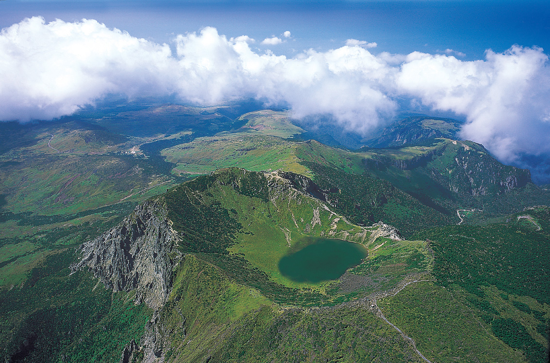
Hallasan, Jeju Island’s shield volcano, last erupted approximately 25,000 years ago and rises 1,950 metres above sea level, making it the highest peak in South Korea. The Geomunoreum lava tube system — part of the same UNESCO inscription — extends 7.4 kilometres underground and contains passages tall enough to accommodate a double-decker bus. The island sits 85 kilometres south of the Korean mainland, with Seoul reachable by a one-hour domestic flight.
Jeju’s lava landscape and Korea’s mainland UNESCO sites 1h by flight from Jeju to Seoul
The UNESCO inscription for Jeju Volcanic Island and Lava Tubes (2007) covers three component areas: Geomunoreum and its connected lava tube system, the tuff cone of Seongsan Ilchulbong, and Hallasan itself. Geomunoreum, 1.5 kilometres from the Hallasan summit zone, formed around 300,000 years ago and is considered the finest example of a multi-branching lava tube system in the world. The tubes maintain year-round temperatures between 11°C and 21°C, and the Manjang Cave section — the only portion open to the public — stretches 1 kilometre and features a 7.6-metre lava column, the largest known inside any lava tube. Seongsan Ilchulbong is a 182-metre tuff cone formed by a phreatomagmatic eruption less than 100,000 years ago; its 600-metre-wide crater holds a grassy interior visible from the surrounding cliffs.
From Jeju International Airport, a one-hour domestic flight to Gimpo or Incheon connects visitors to Seoul and its concentration of inscribed sites. Changdeokgung Palace Complex (UNESCO, 1997) occupies 45 hectares in central Seoul’s Jongno district, a twenty-minute metro ride from Incheon Airport KAL Limousine terminus. Built in 1405 as a secondary palace, Changdeokgung was the seat of the Korean royal family for 270 years after the main Gyeongbokgung was destroyed during the 1592 Japanese invasions. Its rear garden, Huwon, covers 32 hectares and was restricted to royalty for four centuries. The palace’s Injeongjeon throne hall, rebuilt in 1804, preserves the ceremonial layout codified in the Joseon dynasty’s founding statutes almost verbatim.
Hwaseong Fortress in Suwon (UNESCO, 1997) sits 30 kilometres south of Seoul and is accessible in one hour fifteen minutes combining the Jeju flight with the metro to Suwon station. King Jeongjo ordered construction in 1794 to honour his father, Prince Sado, who died locked in a rice chest by royal decree in 1762. The 5.7-kilometre perimeter wall took two and a half years to build and incorporates pulleys, cranes, and block-and-tackle systems described in the official construction manual, the Hwaseong Seongyeok Uigwe, which survives intact. Four of the original forty-eight structures remain — the Paldalmun south gate among them — while the rest were reconstructed after Korean War damage using the original manual as the blueprint.
The historic areas of Gyeongju (UNESCO, 2000) require a one-hour fifteen minute combination of the Jeju flight and a KTX high-speed train from Seoul Station (50 minutes on the KTX-Sancheon). Gyeongju served as the capital of the Silla kingdom for nearly a thousand years, from 57 BCE to 935 CE. The UNESCO zone covers five groups of historic remains: fortresses and palace sites, tumuli (burial mounds), Buddhist monuments, Gyeongju National Museum, and the Yangdong historic village. The Cheomseongdae observatory, built between 632 and 647 CE, is among the oldest surviving astronomical structures in East Asia and stands 9.17 metres tall. Bulguksa Temple (UNESCO, 1995), 16 kilometres from central Gyeongju by bus, was founded in 528 CE and its current wooden structures date from 751 CE, restored after Japanese destruction in 1593.
The women divers of Jeju and Korea’s intangible heritage corridor within Jeju Island; Seoul sites 1h by air
The haenyeo — Jeju’s female free-divers — are inscribed separately on the UNESCO Intangible Cultural Heritage list (2016), not as part of the volcanic island inscription but as a living practice documented since the 5th century CE. The divers work without breathing equipment to depths of up to 20 metres, surfacing with abalone, sea cucumbers, and sea urchins. At their peak in the mid-20th century there were approximately 30,000 haenyeo; today the number is below 4,000 and the average age exceeds sixty. The Haenyeo Museum in Gujwa-eup, 30 kilometres from Jeju City by bus (Route 701), documents their diving techniques, seasonal work rhythms, and the Bulteok — communal change houses on the shore.
The Jongmyo Shrine in Seoul (UNESCO, 1995) stores the spirit tablets of Joseon dynasty kings and queens and is accessible by metro Line 1 or Line 3 to Jongno 3-ga station, seventeen minutes from central Seoul. The main hall, Jeongjeon, was extended progressively from 7 chambers to 19 chambers between 1395 and 1836 as more royal generations required commemoration. The Jongmyo Jerye ritual — music, dance, and ceremony honouring ancestors — is performed on the first Sunday of May and is itself inscribed on the UNESCO intangible list. The wooden building follows a single-storey repetitive module across its 109-metre facade, one of the longest ritual structures in East Asian architecture.
The Gochang, Hwasun, and Ganghwa Dolmen Sites (UNESCO, 2000) extend across three regions of South Korea and represent the largest concentration of megalithic funerary monuments in the world, with over 30,000 dolmens on the peninsula. The Ganghwa dolmens, 70 kilometres west of Seoul by ferry and bus, include a northern-style capstone dolmen weighing approximately 50 tonnes. Ganghwa Island is reached from Sinchon Bus Terminal in about ninety minutes. The dolmens date from the 1st millennium BCE and were built to inter tribal leaders; their distribution pattern has been used to map Bronze Age settlement boundaries across the peninsula.
The Seokguram Grotto and Bulguksa Temple (UNESCO, 1995) stand together on the slopes of Mount Toham, 16 kilometres east of Gyeongju by local bus. Seokguram is a granite artificial grotto completed around 774 CE containing a 3.26-metre-tall seated Buddha carved from a single block of granite. The chamber was designed so that the rising sun on the spring equinox aligns directly with the Buddha’s forehead through the entrance corridor. Japanese colonial administrators attempted to dismantle and reconstruct Seokguram in 1913; the 1961–64 Korean restoration used concrete to stabilize the structure, which introduced a humidity problem that air conditioning systems now partially manage.
Practical information
The best season to visit Jeju is late April through June, when Hallasan’s trails are fully open and the azalea bloom on the upper slopes — the peak season crowds are smaller than in October, when autumn colour draws domestic visitors in large numbers. Both the Eorimok and Seongpanak trails to the Hallasan summit require pre-registration through the Korea National Park Service online system; the summit trail closes if snowfall is forecast. Manjang Cave closes on Tuesdays. Seongsan Ilchulbong charges a 2,000 KRW entrance fee and is busiest at sunrise.
Jeju International Airport has direct international connections to Tokyo, Osaka, Shanghai, and Hong Kong, and over sixty daily domestic flights to Seoul Gimpo and Seoul Incheon. Jeju has no train network; inter-site travel requires buses (frequent on the main coastal ring road, infrequent in the interior) or rental car. A single Jeju–Seoul round trip by plane plus a three-day T-money card covering Seoul metro is the most efficient base for combining the island with mainland UNESCO sites. The Korea Rail Pass (KR Pass) covers KTX trains to Gyeongju but not Jeju flights. Most significant sites are accessible without a guide, though haenyeo demonstration sessions at the Gujwa Haenyeo village run at fixed times (10:30 and 13:00 most weekdays) and are worth timing arrivals around.
Frequently Asked Questions
How long does it take to hike Hallasan and can you do it in a day trip from Seoul?
A day trip from Seoul to Hallasan is possible but demanding. The earliest Gimpo–Jeju flights depart around 06:10, arriving at 07:10; the Seongpanak trailhead is 40 minutes by airport bus plus local bus. The Seongpanak trail is 9.6 kilometres one way to the Baengnokdam crater lake summit and typically takes four to five hours ascending, three descending. The Korea National Park Service closes the summit section if hikers cannot reach the Jindallaebat shelter (7.3 km) by 12:00 in summer or 13:30 in winter, so early arrival is mandatory. Registration must be completed online at least one day in advance. The Eorimok trail (4.7 km) reaches a shelter plateau rather than the summit and is shorter — about two hours each way — and is the practical choice for a half-day visit. Return flights to Seoul Gimpo depart as late as 22:00. The trail is well-signed in Korean and English. Crater lake level varies seasonally but is typically visible from the summit ridge between April and November. Heavy rain or fog regularly closes the summit trail with little advance notice; the National Park website posts closures on the morning of the visit, so checking it the night before and again at 07:00 is advisable.
What is the Geomunoreum lava tube system and why is only one section open to visitors?
The Geomunoreum lava tube system is a network of interconnected underground passages formed by basaltic lava flows from the Geomunoreum parasitic cone approximately 300,000 years ago. The system is 7.4 kilometres long and contains multiple branching passages, some of which are the only lava tubes in the world to preserve cave corals, cave pearls, and flowstone deposits alongside lava stalactites — an unusual combination normally associated with limestone caves rather than volcanic systems. The diversity of secondary mineral formations results from the unusual chemistry of the sea spray infiltrating the porous basalt. Of the several connected sections — Bengdwigul, Yongcheon, Dangcheomul, Gimnyeong, and Manjang — only Manjang is open to the general public. The others are closed to protect their fragile secondary mineral formations from the carbon dioxide, moisture, and bacterial contamination that human visitors introduce. Even inside Manjang, the accessible section is limited to 1 kilometre of the cave’s 13.4-kilometre total length. The cave floor is uneven lava rock; the path is lit and handrailed, but the surface is damp and the 11°C temperature demands a light jacket regardless of outside conditions. Tickets cost 4,000 KRW and the cave is closed Tuesdays.
Is it practical to combine Jeju Island with Gyeongju and Bulguksa in a single trip?
Combining Jeju with Gyeongju and Bulguksa in one trip is practical with a minimum of five days. The most efficient routing is: arrive Incheon or Gimpo, take the KTX from Seoul Station to Gyeongju (two hours on KTX-Sancheon), spend two nights in Gyeongju covering Bulguksa, Seokguram, the tumuli at Daereungwon, and Cheomseongdae, then fly from Daegu Airport (35 minutes from Gyeongju by bus) to Jeju rather than returning to Seoul — Daegu–Jeju domestic flights operate with several departures daily. This avoids retracing to Seoul. Alternatively, fly Jeju first then take KTX from Seoul to Gyeongju on the way back. Gyeongju accommodation ranges from internationally managed hotels near the tumuli park to traditional hanok guesthouses in the old town. Bulguksa is 16 kilometres from the city centre; the local bus takes 40 minutes. Seokguram is an additional 3 kilometres uphill by shuttle bus from the Bulguksa car park. Both are open year-round, though Seokguram’s grotto is seen through a glass partition to protect the humidity-sensitive granite; the view of the Buddha is full-frontal and unobstructed from the entrance.
Sources
- S1 — UNESCO World Heritage Centre — Jeju Volcanic Island and Lava Tubes (Ref. 1264) — https://web.archive.org/web/20230601000000/https://whc.unesco.org/en/list/1264/
- S2 — Jeju World Natural Heritage Center — https://whc.unesco.org/en/list/1264/
- S3 — Seth, Michael J. <em>A History of Korea: From Antiquity to the Present</em>. Rowman & Littlefield, 2010. ISBN: 978-0-8248-3563-7.
Spotted an error? Write to editorial@culturalheritageonline.com and we correct it the same day.