
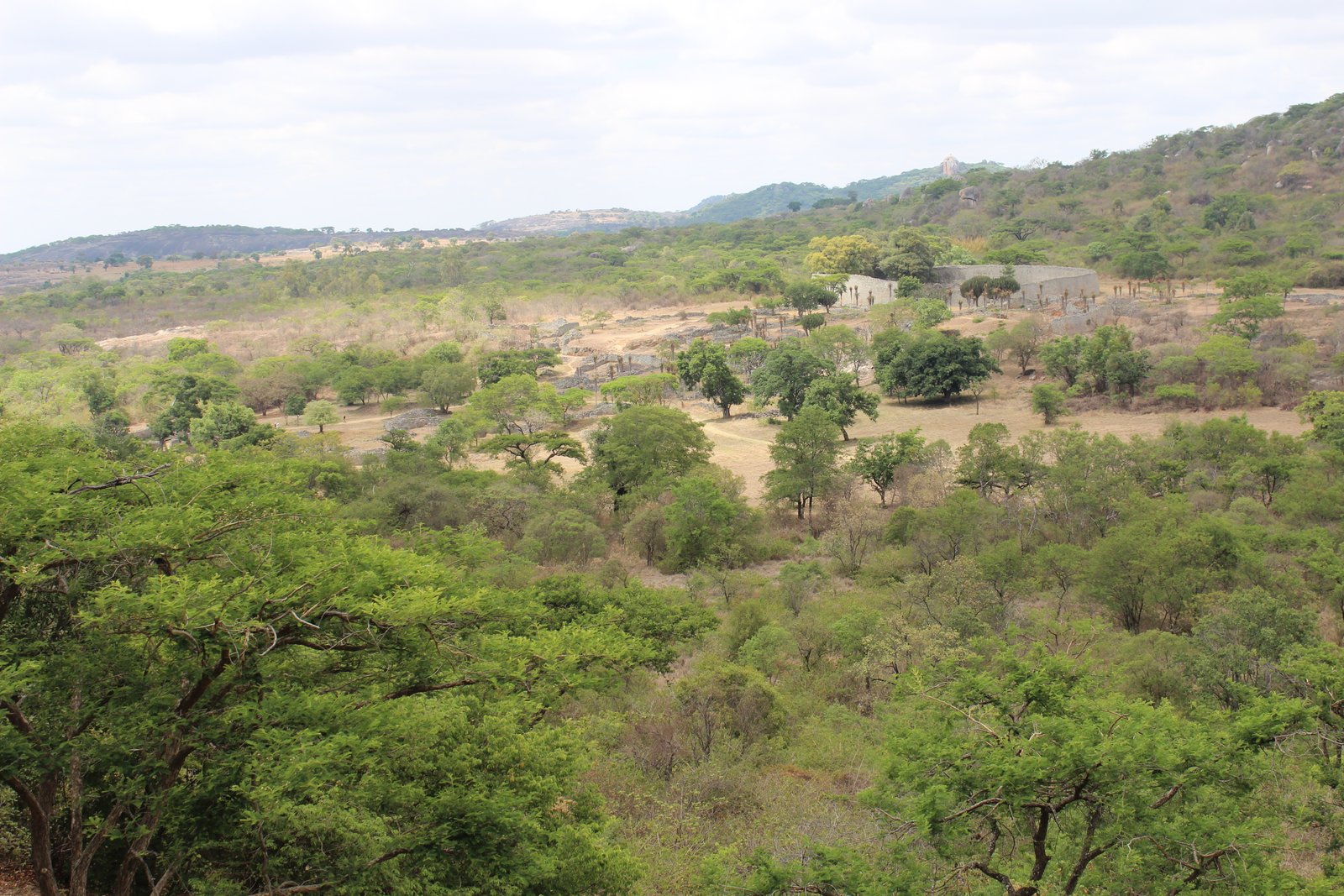
Four UNESCO World Heritage Sites lie within a day’s travel of Harare — stone ruins that rewrote African history, granite hills covered in millennia of cave paintings, a vast floodplain teeming with wildlife, and a waterfall so broad it generates its own weather system. Each demands the journey. From Cultural Heritage Online.
Great Zimbabwe National Monument 290 km southeast · 3.5 hr by road
The walls rise without mortar. Hundreds of thousands of granite blocks, some weighing several tonnes, were fitted together so precisely that the Great Enclosure has stood for six centuries — and continues to stand, indifferent to every explanation imposed on it by later arrivals who refused to believe Africans had built it. UNESCO inscribed Great Zimbabwe in 1986. The site covers nearly 800 hectares and contains the ruins of the medieval capital of the Kingdom of Zimbabwe, a Shona-speaking civilisation that controlled the gold and ivory trade across southern Africa between roughly the 11th and 15th centuries.
There are three main areas. The Hill Complex, the oldest section, occupies a rocky outcrop and gives a commanding view over the valley below; the granite here feels warm underfoot even in cool mornings. The Valley Ruins hold the foundations of the elite residential quarter, its stone-walled enclosures radiating outward from a central passage. The Great Enclosure is the centrepiece: a structure 250 metres in circumference, with walls nearly 10 metres high and 5 metres thick at the base, enclosing a solid conical tower whose purpose is still debated. Walking through the narrow stone passage between the outer and inner walls, where the stones press close on either side, is disorienting — the scale reads differently from inside than from any photograph.
At its height the city housed an estimated 18,000 people and was the political and ceremonial heart of a kingdom that traded as far as China. The eight Zimbabwe birds carved in soapstone — Zimbabwe’s national symbol today — were found here. Several are now in the site museum, which provides essential context before entering the ruins themselves.
Getting there: Drive south from Harare on the A4 toward Masvingo, then follow signs to the monument, approximately 290 km total. Buses run to Masvingo; local taxis cover the final 27 km. Allow: Half a day minimum; a full day to cover all three areas and the museum. Best for: History and archaeology travellers; anyone interested in African pre-colonial civilisations.
Matobo Hills 430 km southwest · 5 hr by road or 50-min flight to Bulawayo
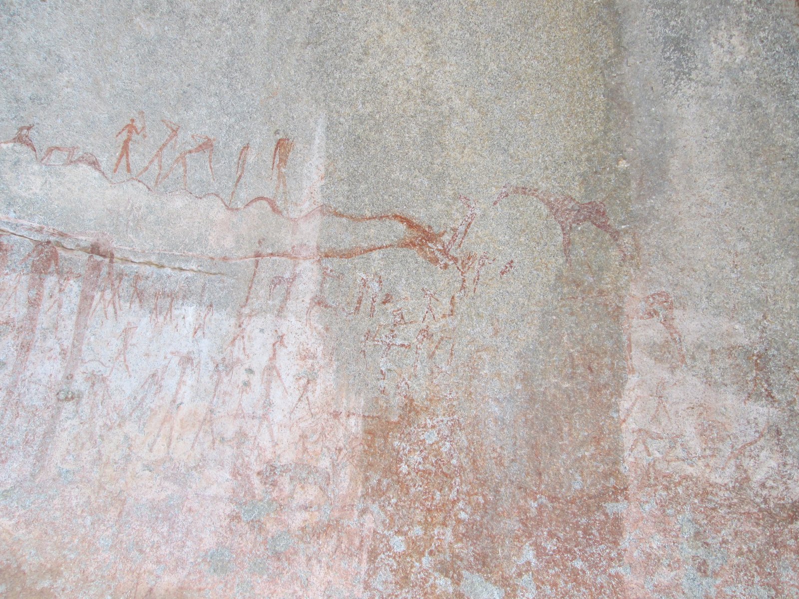
South of Bulawayo, a sea of rounded granite domes — called whalebacks by geologists — erupts from the savannah with the abruptness of something geological and reckless. The Matobo Hills were inscribed in 2003 for a cultural landscape that holds one of the world’s greatest concentrations of San (Bushman) rock art, accumulated over 13,000 years. More than 3,000 individual sites have been recorded. The animals crowd the cave ceilings in red and white ochre: eland, giraffe, elephant, rhino, running figures mid-hunt. Some panels date to the Stone Age; others, in sharper pigment, are far more recent.
The landscape itself functions as the frame. Balancing boulders, some the size of houses, perch on pedestites that look structurally impossible. The hills were sacred to the Ndebele people, who called them Matobo — bald heads. Cecil John Rhodes, the British colonial administrator who gave his name to the country for nearly a century, chose the summit of a hill here called World’s View for his burial site; his grave is cut directly into the granite. You can walk up to it. The views from the top are immense in every direction: flat bush and granite islands stretching to the horizon without interruption.
The Matobo National Park within the hills is one of the few places in Africa where both black and white rhinoceros survive in meaningful numbers. Guided walks to the rhino are possible; the animals are habituated enough to approach on foot, which produces a very different encounter from anything done from a vehicle.
Getting there: Fly to Bulawayo (50 min from Harare), then drive 35 km south to the park entrance; or drive the full 430 km from Harare. Allow: Minimum two days to reach the rock art sites and the rhino sanctuary. Best for: Art history, wildlife, and landscape travellers; those with an interest in colonial history.
Mana Pools National Park, Sapi and Chewore Safari Areas 370 km northwest · 5 hr by road
The Zambezi drops out of the escarpment and spreads across a wide floodplain, leaving behind shallow seasonal pools when it recedes. These are the mana — the Shona word for four. UNESCO inscribed the area in 1984 for its outstanding wilderness value; the park protects 2,196 square kilometres of riverine forest, mopane woodland and floodplain where wildlife concentrations during the dry season can rival East Africa at its peak. Elephant herds numbering in the hundreds come down to drink. Hippos surface and submerge with a sound like slow applause. Wild dogs, the continent’s most endangered large carnivore, den here with some frequency.
What sets Mana Pools apart from most African national parks is walking. Unescorted walking safaris are permitted in parts of the park — a rarity in Africa, where liability concerns and conservation rules typically restrict on-foot access. Moving at human pace through bush where buffalo and lion are present produces a heightened attention that no vehicle conveys. The light on the Zambezi at dawn, reflected off channels of standing water through fever trees, is one of those sights that gets recalled in specific rather than general terms long after the trip ends.
The park is remote and deliberately under-developed. Most camps are unfenced. Facilities are limited to ensure the wilderness character that justified inscription. This is not a site for the risk-averse or the comfort-dependent.
Getting there: Drive north from Harare on the A1 through Makuti, then descend the escarpment road to the park. High-clearance vehicle recommended; the last section is gravel and can be rough. Allow: Three to five days minimum to justify the journey. Best for: Experienced safari travellers; walking safari enthusiasts; photographers willing to earn the image.
Victoria Falls / Mosi-oa-Tunya 440 km west · 5.5 hr by road or 55-min flight
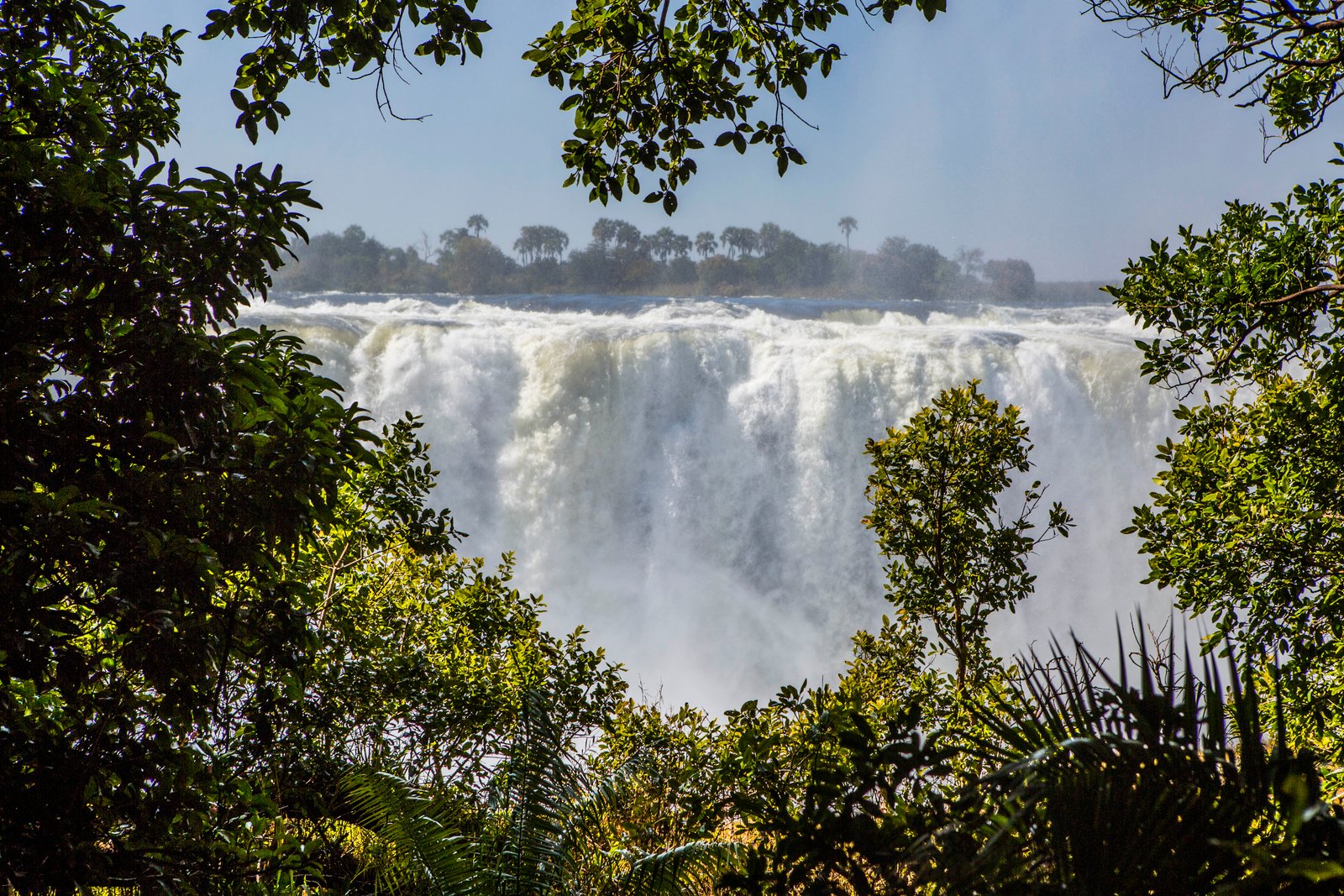
The Kololo people named it Mosi-oa-Tunya — the smoke that thunders — which describes it more accurately than any geological classification. Victoria Falls is 1,708 metres wide and drops between 90 and 107 metres into a basalt gorge, generating a permanent cloud of spray visible from 50 kilometres away during peak flow. UNESCO inscribed the site jointly with Zambia in 1989 as Mosi-oa-Tunya / Victoria Falls. The sheer curtain of falling water is the largest on Earth — not the tallest, not the widest, but the largest by the product of width and height.
Standing at the Zimbabwe viewpoints during high water — roughly February through May — means getting soaked within minutes even in dry weather. The spray rises well above the lip of the gorge and drifts back across the footpath as warm mist. The sound is not a roar so much as a sustained, physical pressure. In low water season (September through November), more of the individual cataracts become visible against the dry black rock, and the Devil’s Pool at the Zambian edge becomes accessible — a natural rock pool at the very rim of the falls where it is possible, with a guide, to swim and look over the edge.
The town of Victoria Falls on the Zimbabwean side is well-developed for tourism; white-water rafting on the Zambezi gorge below the falls, bungee jumping from the bridge, and sunset cruises on the river above are all organised from here. The bridge itself, completed in 1905, crosses the second gorge and connects Zimbabwe to Zambia; walking across it gives a direct view down into the churning water below.
Getting there: Fly from Harare to Victoria Falls Airport (55 min); or drive 440 km west on the A5. Allow: Two days to see both the falls and the gorge. Best for: All travellers; combine with Botswana’s Chobe National Park (70 km away) for an efficient southern Africa circuit.
Frequently Asked Questions
How many UNESCO World Heritage Sites are near Harare?
Four UNESCO World Heritage Sites are accessible from Harare. Great Zimbabwe National Monument (inscribed 1986) and Mana Pools National Park (1984) lie to the southeast and northwest respectively. Matobo Hills (2003) and Victoria Falls / Mosi-oa-Tunya (1989, shared with Zambia) are further west, most easily reached via Bulawayo and a flight.
How do you visit Great Zimbabwe from Harare?
Drive south on the A4 highway to Masvingo — approximately 290 km, around 3.5 hours — then follow signs to the monument 27 km further. Long-distance buses run regularly between Harare and Masvingo; from there, local taxis cover the final stretch. The site museum opens before the ruins; allow at least half a day for both, a full day if you want to walk all three main areas: the Hill Complex, the Valley Ruins, and the Great Enclosure.
What is the best time of year to visit these sites from Harare?
Zimbabwe’s dry season — May through October — is generally preferred for wildlife viewing at Mana Pools and for road travel to all sites. Mana Pools is at its peak in September and October, when animals concentrate around the remaining water. Victoria Falls reaches maximum volume and spray between February and May; the low-water season from September to November reveals more rock faces and allows access to Devil’s Pool. Great Zimbabwe and Matobo Hills are accessible year-round, though the summer rainy season (November through March) can affect dirt road conditions.
Who built Great Zimbabwe, and what happened to the civilisation?
Great Zimbabwe was built by ancestors of the Shona people between roughly the 11th and 15th centuries CE, reaching its peak as a trading city of perhaps 18,000 inhabitants around 1350. The Kingdom of Zimbabwe controlled the gold and ivory trade between interior southern Africa and the Swahili coast, connecting through intermediaries to Indian Ocean commerce as far as China and Persia. The city was abandoned around 1450, likely due to environmental pressure — overgrazing and deforestation — combined with a shift in trade routes southward toward the Limpopo. No writing system was used; the architecture and the objects recovered, including Chinese porcelain and Persian glass, are the primary evidence of the kingdom’s reach.
Sources
- S1 — Garlake, Peter S. Great Zimbabwe. Thames & Hudson, 1973. ISBN 978-0-500-39012-2.
- S2 — Beach, David. The Shona and Zimbabwe 900–1850. Heinemann, 1980. ISBN 978-0-435-94505-3.
Spotted an error? Write to editorial@culturalheritageonline.com and we correct it the same day.



.jpg)

.jpg)