Santo Domingo’s Zona Colonial was the first permanent European city in the Americas: founded in 1498 by Bartholomew Columbus, built on a street grid that became the template for every Spanish colonial capital that followed, and still home to the continent’s oldest standing cathedral, oldest European fort, and oldest paved street. UNESCO inscribed the colonial city in 1990.
The Blueprint for an Empire’s Cities Zona Colonial, western bank of the Río Ozama
When Bartholomew Columbus — Christopher’s younger brother — relocated a struggling settlement from the eastern bank of the Ozama River to its western bank in 1498, he was establishing what would become the administrative and logistical hub for the entire Spanish colonial enterprise in the New World. For the first three decades of the 16th century, before the conquest of Mexico and Peru shifted Spain’s attention westward and southward, Santo Domingo was the most important city in the Americas. Everything that would later define Spanish colonial urbanism — the grid of rectangular blocks radiating from a central plaza, the fortified waterfront, the institutional buildings grouped around a main square, the church facing the plaza — was tried here first.
Governor Nicolás de Ovando laid out the new city after a hurricane destroyed much of the original settlement in 1502. His plan imposed a strict orthogonal grid on the peninsula between the river and the sea. The logic was practical: straight streets allowed cavalry to patrol quickly, channelled sea breezes through residential blocks, and placed each major institutional building — the cathedral, the governor’s palace, the fort — within sight lines of the others. The grid was replicated, with modifications for local terrain, in Mexico City (founded 1521), Lima (1535), Buenos Aires (1580), and dozens of cities between. The Zona Colonial of Santo Domingo is therefore not merely a historic city but the source code for an entire tradition of urban planning.
The site covers roughly 1 km² on the western bank of the Ozama, bounded by the river, the sea, and the remains of the colonial wall. Most of the original 16th-century buildings survive in some form, though many were modified in later centuries. The Zona Colonial is not a museum district: it has a permanent residential population, active commerce along its main pedestrian street, and a nightlife economy centred on the bars and restaurants that occupy colonial-era ground floors. UNESCO’s inscription in 1990 recognised the integrity of the urban fabric as much as the individual monuments.
The broader heritage geography of Hispaniola is sparse by Caribbean standards. The island was divided between Spanish Santo Domingo (now the Dominican Republic) and French Saint-Domingue (now Haiti) in 1697, and neither portion developed the plantation architecture or fortification networks that would later earn inscriptions at sites like Willemstad in Curaçao or the Garrison in Bridgetown, Barbados. The nearest UNESCO site from a different national tradition is Old Havana and its Fortification System in Cuba, approximately 1,200 km to the northwest — itself a city shaped in part by the administrative patterns first established in Santo Domingo. The Zona Colonial is therefore genuinely isolated in heritage terms: there are no easy day-trip comparisons, and the site must be understood on its own terms as the origin point of a tradition rather than one example among many.
What the Zona Colonial does offer is an unusually complete picture of a single formative moment. The Fortaleza Ozama, the Cathedral of Santa María la Menor, the Alcázar de Colón, and Calle de las Damas together span the period from 1502 to 1540 — the roughly four decades during which the Spanish crown transformed an explorers’ camp into a functioning colonial capital. No other location in the Americas preserves this founding era in such density across such a small area.
The Cathedral Columbus Came Home To, and the Fort That Never Fell Calle Las Damas and Plaza de Colón, Zona Colonial
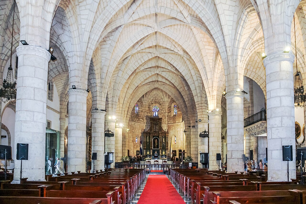
The Cathedral of Santa María la Menor was begun in 1512 and completed in 1540 — the oldest cathedral in the Western Hemisphere. Construction proceeded slowly across three decades because skilled masons and building materials had to come from Spain or be improvised locally, and because the colonial project kept redirecting both labour and resources toward the conquest of the interior. The result is an eclectic structure: the floor plan is Gothic, the decorative vocabulary shifts toward Renaissance detail on the south portal, and later additions have layered Baroque elements into the interior. This formal heterogeneity is not a flaw but a historical record — each wave of 16th-century European style arrived in the Americas and found its first expression here.
The cathedral is best known, outside the Dominican Republic, as the site associated with the remains of Christopher Columbus. The complicated afterlife of Columbus’s bones — transferred from Valladolid to Hispaniola in 1537, then to Havana when Spain ceded the island to France in 1795, then returned to Santo Domingo in 1898 — has been disputed for over a century. DNA evidence published in 2006 suggested that remains in Seville’s cathedral may be the authentic ones. The Dominican Republic maintains that the bones in the Faro a Colón lighthouse memorial, built in 1992 across the Ozama River, are genuine. The cathedral retains a cenotaph and chapel associated with Columbus regardless, and the historical dispute has not diminished the building’s importance as a functioning cathedral and heritage monument.
Calle de las Damas — the Street of Ladies — runs parallel to the Ozama riverfront and is the oldest paved street in the Americas, named for María de Toledo, wife of Diego Columbus (Christopher’s son and successor as governor), who promenaded here with her ladies-in-waiting in the early 16th century. The street connects two of the most important secular monuments: the Fortaleza Ozama at the southern end and the Alcázar de Colón to the north.
The Fortaleza Ozama, built between 1502 and 1508, is the oldest European military fortification still standing in the Americas. The Torre del Homenaje — a square keep — dominates the structure and remains largely intact. The fort controlled the mouth of the Ozama River and served as the primary defensive installation for the colonial capital. Its walls were built to resist cannon fire, and they did: despite repeated attacks and pirate raids over three centuries, the fortification was never taken by assault.
The Alcázar de Colón, built between 1510 and 1514 for Diego Columbus, was the first stone palace in the Americas and served as the seat of colonial government during the period when Santo Domingo administered all Spanish territories in the New World. The two-storey structure with its arcaded facade is now a museum housing a collection of 16th-century furnishings and decorative arts reconstructed from inventories and archaeological evidence. The roofline, with its crenellated parapet, reflects the transitional moment between medieval castle and Renaissance villa — appropriate for a building that housed the son of an explorer who died believing he had reached Asia.
Practical information
The Zona Colonial occupies the western bank of the Ozama River in central Santo Domingo and is walkable from end to end in under 30 minutes. Las Américas International Airport is 30 km east of the city; taxis take approximately 40–50 minutes depending on traffic. Most of the major monuments are concentrated within a few blocks of Plaza de Colón and Calle de las Damas.
The Cathedral of Santa María la Menor is open for visitors daily except during morning and early-evening services; a small donation is customary. The Alcázar de Colón charges a modest admission fee and the Fortaleza Ozama is also ticketed. The Museo de las Casas Reales on Calle de las Damas, housed in the former Royal Audience building, covers colonial history in detail and merits at least an hour of visit time.
The Zona Colonial has its own dedicated police unit and is generally safe during the day. Evening activity concentrates around the western end of Calle El Conde and the bars near Plaza España. Accommodation ranges from boutique hotels in restored colonial buildings to larger chain properties just outside the historic zone. The best visiting months are December through March, when temperatures are mild and humidity is lower; the rainy season runs from May through October, with the peak of hurricane season in August and September.
Frequently Asked Questions
Why is Santo Domingo called the oldest city in the Americas?
The claim requires some precision. Earlier European landfalls and short-lived settlements preceded Santo Domingo — Columbus’s first fort, La Navidad, was built on the north coast of Hispaniola in 1492 from the wreckage of the Santa María, but it was destroyed within months. La Isabela, founded in 1493 on the north coast, was the first planned European town in the Americas, but it was abandoned by 1498. What Santo Domingo has that no earlier settlement achieved is continuous habitation from its foundation to the present day. When Bartholomew Columbus relocated the settlement to the western bank of the Ozama in 1498, he created a city that has been continuously occupied ever since. The street grid laid out by Ovando in 1502 is still the basic structure of the Zona Colonial today. For this reason — continuous urban occupation with surviving built fabric from the first decades of the 16th century — Santo Domingo holds the designation of oldest permanent European settlement in the Americas, and its colonial district is the oldest surviving planned European urban area in the Western Hemisphere. The UNESCO inscription in 1990 under criteria (ii), (iv), and (vi) reflects this: the site is recognised not only for its architectural integrity but for its role in transmitting the model of Spanish colonial urban planning to the rest of the continent.
Where are Christopher Columbus’s remains, and does it matter for visiting Santo Domingo?
The question of Columbus’s remains is one of the more protracted disputes in heritage history. Columbus died in Valladolid, Spain, in 1506. He was initially buried there, then moved to Seville. In 1537, at the request of his family, remains described as Columbus’s were transferred to Hispaniola and interred in the cathedral at Santo Domingo. In 1795, when Spain ceded the island to France under the Treaty of Basel, the remains were transferred again — to Havana, Cuba. In 1898, following the Spanish-American War, they were moved back to Seville, where they now rest in the cathedral in an elaborate tomb. In 1877, workers at Santo Domingo Cathedral discovered a lead box containing bones and an inscription identifying the contents as Columbus’s remains. The Dominican Republic maintains that the 1795 transfer took the wrong bones, and that the 1877 box holds the authentic Columbus. A 2006 DNA study compared the Seville remains to known Columbus relatives and found a match; the Santo Domingo box was not available for comparison. The practical answer for visitors: the Faro a Colón memorial holds what the Dominican Republic claims are Columbus’s remains; the cathedral has a chapel and cenotaph associated with his legacy regardless. Both are worth seeing. The unresolved dispute is itself part of the site’s history — a postcolonial argument about who has rightful claim to the man who initiated the conquest.
What is the significance of Calle de las Damas beyond being the oldest paved street in the Americas?
Calle de las Damas runs the length of the eastern edge of the Zona Colonial, parallel to the Ozama River, and connects the Fortaleza Ozama at its southern end to the Alcázar de Colón and the Casa de Bastidas to the north. As a physical space it is a remarkably intact piece of 16th-century urban planning: the paving stones are modern replacements but the alignment, the buildings, and the spatial relationship between fort, palace, and river are essentially unchanged from the colonial period. The name commemorates María de Toledo, niece of the Duke of Alba and wife of Diego Columbus, who governed Hispaniola on behalf of the Spanish Crown from 1509. The ladies of her court promenaded on this street in the early 16th century, making it simultaneously a social space and a demonstration of the courtly culture that the Spanish colonial elite sought to transplant to the New World. For historians of urbanism, the street matters because it demonstrates how deliberately the early colonial city was designed to project power and social hierarchy through the arrangement of public space — the fort controlling the river, the palace adjacent to the fort, the ceremonial street connecting them and visible from the water to approaching ships. Walking Calle de las Damas today from the Torre del Homenaje to Plaza España still has this quality of directed movement through an officially sanctioned landscape.