The Central Highlands of Sri Lanka, inscribed as a UNESCO World Heritage Site in 2010, is a composite site covering three protected areas — Peak Wilderness Protected Area, Horton Plains National Park, and the Knuckles Conservation Forest — with a combined area of approximately 56,000 hectares. The highest point in Sri Lanka, Pidurutalagala at 2,524 metres, falls within the designation. The highlands are also where a single fungal pathogen, spreading through Ceylon’s coffee plantations between 1869 and 1879, forced a shift to tea cultivation that reshaped the island’s landscape, economy, and demographic composition permanently.
Three Protected Areas: Sacred Peaks, 880-Metre Escarpments, and Cloud Forest Ridges Composite site across central Sri Lanka, 56,000 hectares total
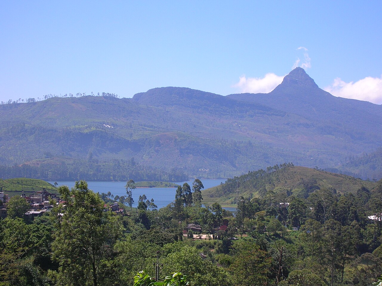
The Peak Wilderness Protected Area is the largest and wildest of the three components. It covers a rugged terrain of ridges, valleys, and peaks in the Ratnapura and Nuwara Eliya districts. Adam’s Peak — Sri Pada in Sinhala — stands at 2,243 metres and is the summit most visited by pilgrims. The rock formation at the peak summit measures approximately 1.8 metres long and 0.8 metres wide and has been interpreted as a sacred footprint by multiple religious traditions for more than a millennium. Buddhist tradition identifies it as the left footprint of the Gautama Buddha; Hindu tradition attributes it to Shiva; Christian and Muslim accounts hold that Adam, expelled from paradise, placed his foot here on first arrival on earth. The convergence of these claims in a single geological feature on a small island is without close parallel elsewhere in Asia.
Buddhist pilgrimage to Adam’s Peak is documented from at least the 10th century CE; Chinese traveller Fa Xian described it in the 5th century CE, though his reference is to the site generally rather than to a mass pilgrimage. The modern climbing route from Dalhousie village ascends approximately 5,500 steps cut into the mountain face; pilgrims begin the ascent at midnight to reach the summit for sunrise, when shadow effects in the morning light create a triangular shadow of the peak that projects across the lowlands. The climbing season runs December through May, during the dry months when the path is passable; the path is closed informally during the wet season when cloud cover makes the summit ascent unrewarding and the trail hazardous. At peak season (January–February), tens of thousands of pilgrims make the ascent each week.
Horton Plains National Park is the component most accessible to visitors who are not undertaking the Adam’s Peak pilgrimage. The plateau sits at approximately 2,100 metres, making it among the highest terrain accessible by road in Sri Lanka. The dominant landscape is a combination of patana grassland (endemic montane grassland maintained partly by historical burning practices), montane cloud forest, and scrub. The World’s End escarpment, reached by a 4-kilometre walking trail from the park entrance, is the plateau’s most dramatic feature: the land drops 880 metres over a near-vertical cliff face to the lowland jungle below. On clear days, which require an early morning arrival before cloud builds, the view extends to the southern coastline. Sambar deer (Rusa unicolor) graze on the open grassland in the early morning hours and are regularly encountered along the trail. The endemic Sri Lanka whistling thrush (Myophonus blighi) and the dusky-blue flycatcher (Eumyias sordidus) are among the bird species found here and nowhere outside Sri Lanka.
The Knuckles Conservation Forest — named for the series of peaks that, seen from Kandy, resemble knuckles on a clenched fist — covers terrain between 900 and 1,863 metres and was formally added to the UNESCO World Heritage designation in 2010 as the third component. The forest holds 34 endemic vertebrate species and a distinct flora influenced by both wet-zone and dry-zone climatic conditions, as the Knuckles range lies at the ecological boundary between the two zones. Traditional agricultural communities have maintained shifting cultivation practices in the buffer zones of the Knuckles for centuries; the continuation of these practices alongside the forest is part of the landscape character UNESCO cited in the inscription.
Tea, Coffee Rust, and the Colonial Agricultural Transformation That Made This Landscape Nuwara Eliya and Hatton districts, 1,500–2,000m elevation
The visual character of the Central Highlands today — geometric rows of tea bushes covering hillsides from valley floor to ridge, broken by factory buildings and colonial-era bungalows — is the product of a biological catastrophe. Ceylon’s colonial economy in the mid-19th century rested on coffee. British planters had established estates across the highlands from the 1840s onward, and by the early 1860s the Ceylon coffee industry covered approximately 275,000 hectares, making it one of the largest in the British Empire. The estates employed Tamil workers brought from southern India in organised migration schemes managed by the colonial administration; this demographic movement, which brought hundreds of thousands of Tamil-speaking workers to the highlands, permanently altered the ethnic composition of the region.
In 1869, the fungal pathogen Hemileia vastatrix — coffee leaf rust — was first documented in Ceylon. The pathogen spreads by airborne spores that colonise the underside of coffee leaves, causing them to drop and progressively killing the plant. The conditions of highland Ceylon — humid, densely planted, with little natural resistance in the introduced Coffea arabica variety — were ideal for the pathogen’s spread. By 1879, a decade after first identification, the disease had destroyed the viable yield of most coffee estates in the highlands. Individual planters lost their entire investments. The colonial government made limited attempts at mitigation but had no effective response to a pathogen for which no treatment existed.
The shift to tea was not immediate or fully planned. Some planters abandoned the highlands entirely. Others experimented with cinchona (the source of quinine) and cardamom. The decisive pivot came when planters observed that Camellia sinensis, the tea bush that had proven viable in Assam in northeastern India under British management, could be grown in the Ceylon highlands at comparable altitudes and rainfall levels. The first commercial tea estates in Ceylon were established in the 1870s, and by the 1890s tea had entirely replaced coffee as the dominant crop. Ceylon Tea — the branding that distinguished the island’s product from Chinese and Indian competitors — became one of the most commercially effective commodity brands of the late Victorian period. Sri Lanka today is the world’s fourth largest tea exporter.
Nuwara Eliya, the highest town in Sri Lanka at 1,868 metres, was the administrative centre of this colonial tea economy and retains a built environment that reflects its history: a Victoria Park, a golf course, a racecourse, and colonial bungalows with English-style gardens. The town sits within the highland zone but is not itself a component of the UNESCO designation; it functions as the practical base for visitors exploring Horton Plains (30 kilometres by road) and the broader tea country. The Hatton district, to the northwest, holds several of the oldest continuously operating tea estates, some dating from the 1880s.
Kandy, 35 kilometres northwest of the Horton Plains entry point and a UNESCO World Heritage Site since 1988, was the last independent royal capital of Sri Lanka before British annexation in 1815. The Temple of the Sacred Tooth Relic (Dalada Maligawa) in Kandy houses what Buddhist tradition holds to be a tooth of the historical Buddha, brought to Sri Lanka from India in the 4th century CE. The relic was physically present in the capital because its possession was tied to the legitimacy of Kandyan kingship — the king who held the tooth relic held the right to rule. The Portuguese reportedly seized and destroyed a relic they believed was the tooth in 1560; Sinhalese tradition holds that they destroyed a replica and the true relic was hidden. The current tooth shrine complex was substantially expanded in the 17th and 18th centuries and survived British colonial rule largely intact.
Sinharaja Forest Reserve, 40 kilometres south of the highlands, is the lowland ecological counterpart to the montane habitats of the highland designation: where the highlands contain cloud forest and montane species, Sinharaja holds the last viable lowland tropical rainforest in Sri Lanka, with 60% of the island’s endemic tree species and 21 of its 26 endemic bird species. The two sites together provide a transect through most of Sri Lanka’s endemic biodiversity.
Practical Information Central Highlands, Nuwara Eliya and Kandy districts, Sri Lanka
The highlands are accessible by train and road. The Kandy–Badulla line, considered among the most scenic railway journeys in Asia, crosses the highlands with stops at Hatton (for Adam’s Peak, 8km from Dalhousie) and Nuwara Eliya (alighting at Nanu Oya station, 8km from town). Journey time from Colombo to Nanu Oya is approximately 5.5 hours. Horton Plains National Park is 30 kilometres from Nuwara Eliya by road; no public transport serves the park gate directly, and vehicles must be hired or taxis arranged. The park opens at 6:00 AM; arriving early is essential because the plateau frequently clouds over by 10:00–11:00 AM, eliminating visibility at World’s End.
Adam’s Peak pilgrimages depart from Dalhousie from around midnight during the December–May season; the ascent takes 3–4 hours depending on fitness and crowd conditions. Buses connect Hatton and Dalhousie during the pilgrim season. The Knuckles Conservation Forest is best approached from Kandy, approximately 30 kilometres east, where guides can be hired for overnight trekking routes. Temperature in the highlands ranges from 7–18°C year-round at 2,000m elevation — considerably colder than lowland Sri Lanka, and rain gear is necessary regardless of season. Sri Lanka’s ETA visa covers the highlands; no special permits are required beyond the national park entrance fees at Horton Plains.
Frequently Asked Questions
Why is Adam’s Peak considered sacred by four different religious traditions, and how has this shaped the pilgrimage site?
Adam’s Peak’s multi-faith significance rests on a convergence of textual interpretation and topographic coincidence. The rock formation at the summit — a shallow depression roughly 1.8 metres long and 0.8 metres wide — was interpreted as a sacred footprint by different communities at different periods of the site’s documented religious history. Buddhist pilgrimage is the oldest continuously documented tradition: the Chinese Buddhist monk Fa Xian mentioned the site in accounts from his 5th-century visit to Sri Lanka, and Sinhalese Buddhist sources describe it as the footprint of the Buddha from at least the 10th century CE. Hindu tradition, drawing on the presence of Tamil Hindu communities in Sri Lanka, associates the footprint with Shiva. Islamic and Christian accounts — developed partly through the influence of Arab traders who documented the site in medieval travel literature — identify the footprint with Adam, the first man, who according to Quranic and Biblical tradition was expelled from paradise and set down on earth; the isolation of the peak, visible from a great distance, gave it plausibility as a first landing point. The coexistence of these traditions at the same physical site has made Sinharaja one of the rare places in Asia where pilgrims from Buddhist, Hindu, Muslim, and Christian backgrounds ascend the same path with different devotional intentions. The summit shrine and the tea stalls along the path serve all groups without distinction, and the administration of the site has historically been managed by Buddhist monks while remaining physically accessible to all. This multi-faith character is explicitly mentioned in the UNESCO inscription for the Peak Wilderness Protected Area.
How did the coffee leaf rust of 1869–1879 permanently change the Central Highlands?
The catastrophic spread of Hemileia vastatrix through Ceylon’s coffee estates between 1869 and 1879 is one of the most thoroughly documented cases of agricultural collapse caused by a single pathogen. The fungus, which kills coffee plants by preventing photosynthesis through leaf drop, spread through the densely planted highland estates in conditions that maximised spore transfer: humid air, close planting distances, and a monoculture of Coffea arabica that had no genetic resistance to the pathogen. By 1879, the effective yield of most estates was zero. The consequences were structural and lasting. First, the Tamil labour force that had been brought from southern India to work the coffee estates remained in Sri Lanka without the industry that justified their migration; they were redeployed into the emerging tea economy under conditions of debt bondage and restricted movement that persisted into the 20th century. Second, the landscape was physically altered: tea bushes were planted at different altitudes and densities than coffee, requiring new terracing, road construction, and factory infrastructure. The factory buildings — large structures needed to process fresh-picked tea leaves within hours of harvest — became anchors of the highland landscape that remain operational today. Third, the shift to tea introduced a new social hierarchy of estate management: Scottish and English superintendents managing Indian Tamil workers under Sinhalese government oversight, a three-layer structure that contributed to inter-ethnic tensions that became politically significant in independent Sri Lanka. The coffee rust of the 1870s is therefore not merely an agricultural historical event but a precondition for the contemporary social geography of the Central Highlands.
What is the best time of year to visit Horton Plains National Park, and what should visitors prepare for?
Horton Plains is accessible year-round, but the practical conditions vary significantly by season. The drier months from December through March provide the clearest skies and best visibility at World’s End — the escarpment view that is the primary destination for most visitors. April and May are transitional; the southwest monsoon arrives in late May and brings persistent cloud and rain to the plateau that limits visibility at World’s End to near zero on most days. June through September is the wettest period. October–November marks another transitional phase before the northeast monsoon, which brings less rainfall to the highlands than the southwest monsoon. Regardless of season, cloud builds rapidly over the plateau after 10:00 AM; visitors who arrive at the park gate at or before 6:00 AM consistently report clear conditions at World’s End, while those arriving after 9:00 AM frequently find the escarpment obscured. The walking distance to World’s End from the park entrance is approximately 4 kilometres (one way), with a further 1.5 kilometres to Baker’s Falls, making the standard circuit 9 kilometres. The terrain is mostly flat with some muddy sections; waterproof boots and a fleece layer are appropriate even in December. No overnight camping is permitted inside the park. Vehicles must be left at the park entrance; no private vehicles are allowed beyond the gate.