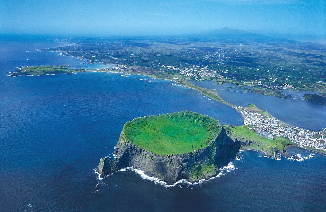
Jeju Volcanic Island and Lava Tubes, inscribed by UNESCO in 2007, protect three components of a volcanic island formed approximately 1.8 million years ago by submarine eruptions that built a shield volcano above sea level, creating South Korea’s largest island (1,849 km²) and its highest peak — Hallasan (한라산, 1,950 m, a shield volcano whose name means “Mountain That Can Pull Down the Milky Way”). The three inscription components are: Hallasan Natural Reserve (한라산천연보호구역, covering the 9.3 km² summit area and the highest ecological zones of Jeju), the Geomunoreum Lava Tube System (거문오름 용암동굴계, a connected network of seven lava tube caves formed approximately 100,000–300,000 years ago, including Manjanggul Cave at 13.4 km the world’s longest known lava tube and Bengsik Lava Tube with the tallest lava stalactites known — basalt columns 30 cm in diameter formed by dripping lava re-solidifying as the main flow drained out), and Seongsan Ilchulbong Tuff Cone (성산일출봉, “Sunrise Peak”, an approximately 5,000-year-old tuff cone formed by a phreatomagmatic eruption where rising magma contacted seawater, building a crater-topped cone 180 metres above sea level on the eastern tip of Jeju, now connected to the island by a narrow land bridge formed by post-eruption sediment deposition).
Jeju’s volcanic landscape circuit Hallasan summit trails · Manjanggul Cave · Jeju Folk Village · Udo Island — 5 to 30 km
Five Kilometres north of the Seongsan Ilchulbong tuff cone by road, Udo Island (우도, “Cow Island”, a small volcanic island approximately 3.8 km² accessible by ferry from Seongsan Port, 15 minutes crossing), is the most easily visited subsidiary island of Jeju and a volcanic landscape in its own right: the island’s main summit (Udobong, 132 m) is a scoria cone, the coastal cliffs expose the island’s layered basalt geology, and the Hwudusundang Beach (홍도해수욕장) on the island’s northern shore has the only coral-sand beach in Korea (the white sand composed of ground coral fragments from the surrounding reef — distinctly different from the dark volcanic sand beaches on Jeju’s main island). Udo is most crowded in summer (July–August); the spring wildflower season (April–May, when the island’s rapeseed fields bloom) and autumn (October–November) are the recommended visiting seasons. The walking circuit around Udo’s coast (approximately 12 km, 3–4 hours) combines cliff-edge coastal scenery with the basalt geology and the fishing-village traditional culture of the haenyeo (해녀, the famous Jeju diving women who have harvested abalone, sea urchin, and seaweed from the surrounding waters for over 1,500 years — a tradition now inscribed on UNESCO’s Intangible Cultural Heritage list). From Seongsan, ferries to Udo depart every 30–60 minutes from Seongsan Pier; Seongsan is connected to Jeju City by bus (approximately 1 hour) and by rental vehicle.
Thirty Kilometres west of Seongsan along the northern coast of Jeju, the Manjanggul Lava Tube Cave (만장굴, in the Geomunoreum Lava Tube System, the second of the inscription’s three components) is the world’s longest accessible lava tube at 7.4 km of visitor-accessible tunnel (the full cave system extends 13.4 km but most is closed for conservation). The cave’s main corridor reaches widths of 18 metres and heights of 23 metres at its widest point, with its floor showing successive lava bench formations (“lava ledges” formed by the solidification of successive lava flow events at different flood levels). The cave terminus (the end of the publicly accessible section) contains a 7.6-metre basalt lava column — the world’s largest known lava column, formed by lava dripping from the ceiling and solidifying as the remaining molten lava drained out. The cave temperature maintains a constant 11–13°C year-round, making it a cool refuge in summer and requiring warm clothing in winter. The Geomunoreum cinder cone itself (거문오름, a parasitic cone on Hallasan’s northern flank, approximately 456 m elevation) is the source of the lava flows that formed the tube system; the Geomunoreum hiking trail (approximately 3 hours, guided only, advance booking required at the Geomunoreum Lava Tube System Visitor Centre) is a separate UNESCO component visit from the cave tour. Hallasan summit hiking (the main summit Baeknoktam crater lake at 1,950 m) requires a full day (the Seongpanak trail, 9.6 km, 4–5 hours ascent from the southern trailhead, or the Gwaneumsa trail, 8.7 km, 4–5 hours from the northern trailhead); summit access is restricted when visibility falls below safety thresholds.
Practical information
Jeju Island is served by Jeju International Airport (CJU), approximately 3 km west of Jeju City centre, with multiple daily flights from Seoul Gimpo (GMP, approximately 1 hour), Seoul Incheon (ICN, approximately 1 hour 10 minutes), Busan (approximately 1 hour), and other Korean cities, plus international flights from Tokyo, Osaka, Shanghai, and other regional cities. A ferry connection from Mokpo (approximately 5–6 hours) and Busan (approximately 13 hours on overnight ferry) provides an alternative for visitors wishing to bring vehicles. Public bus (Jeju Cross-Island Bus and city bus network) connects the major tourist sites (Jeju City, Seogwipo City, Seongsan, Jungmun Resort, Manjanggul) with reasonable frequency; rental car is the most practical option for independent visitors, and rental rates are competitive. Seongsan Ilchulbong Tuff Cone: walk to the summit crater (approximately 30 minutes steep climb, 422 steps on the main path), open daily from sunrise (timed entry for sunrise viewing); admission fee. Manjanggul Lava Tube: Tuesday–Sunday 09:00–18:00 (last entry 17:10), closed Monday; admission fee; 1 km of cave accessible on a self-guided circuit. Geomunoreum hiking: guided only, 3 times per day, advance booking required (Jeju World Natural Heritage Centre website); limited daily entry numbers. Hallasan summit: year-round, but the summit area closes in severe weather (winter ice conditions common November–March); the Eorimok trail (5.8 km, 2.5 hours one way) reaches the alpine meadow but not the summit; only the Seongpanak and Gwaneumsa trails reach the Baeknoktam crater lake. Best season: spring (April–May, cherry blossom and rapeseed flowers), autumn (October, maple and oak foliage on Hallasan).
Frequently Asked Questions
What is a lava tube and how did the Geomunoreum system form?
A lava tube is a natural conduit formed during a basaltic lava flow event when the outer surface of the flow solidifies into a hard crust while the molten interior continues to flow, eventually draining out through a downstream break and leaving a hollow tunnel. The Geomunoreum lava tube system formed approximately 100,000–300,000 years ago during a series of eruptions from the Geomunoreum parasitic cone on the northern flank of Hallasan; the eruptions produced fluid basalt flows (low-viscosity tholeiitic basalt characteristic of shield volcano eruptions) that flowed northward from the 456-metre-elevation cone to the coast, approximately 13 km. The tube system formed when the low-viscosity basalt flowed in confined channels whose outer surfaces cooled rapidly against the surrounding rock and air, while the interior temperature remained above 1,200°C and the flow continued. As eruptions subsided and the magma supply decreased, the interior basalt drained out through the seaward terminus and into the sea, leaving the solidified outer tube shell as an empty cave. The Geomunoreum system’s geological distinctiveness — recognised specifically in the UNESCO inscription — lies in the preservation of multiple tubes from different lava flow events stacked vertically (the Manjanggul, Gimnyeonggul, Yongcheongul, and other tubes in the system were formed by different eruptions at different times and are interconnected at points where tubes from different flows intersect), producing a cave complex whose cross-section shows the sedimentary layering of successive lava events. The secondary cave formations (the basalt stalactites, flowstone floors, and lava columns) form after the initial tube opening by residual lava seeping through cracks in the roof and dripping onto the floor — a post-emptying decoration process analogous to limestone stalactite formation but proceeding at much slower rates (basalt is poorly soluble in water, unlike limestone, so the formations are primarily mechanical drip-solidification rather than chemical dissolution and re-precipitation).
Who are the haenyeo and what is their relationship to Jeju’s cultural identity?
The haenyeo (해녀, “sea women”) are female free divers who harvest seafood — abalone (전복, jeonbok), sea urchin, conch, sea cucumber, and various seaweeds — from the waters around Jeju Island and the nearby Korean coast, using breath-hold diving techniques without any breathing apparatus in water temperatures ranging from 10°C (winter) to 27°C (summer), at depths typically of 5–10 metres but occasionally to 20 metres. The practice is documented in Korean historical records from as early as the 5th century CE, and Jeju haenyeo are referenced in the 17th-century Joseon encyclopaedia Jihwa as a recognised female occupational group. The haenyeo tradition became female-dominated in the early Joseon period (approximately 15th–17th centuries CE) through a combination of factors: the Joseon state’s taxation of marine harvests led male divers to avoid the trade (women were exempt from the maritime harvest tax until the late Joseon period), and the specific physiological characteristics of female breath-hold capacity (women’s higher average body-fat percentage increases thermal insulation and buoyancy in cold water, and the female pelvic musculature may provide greater core breath-holding support) appear to have provided a biological advantage in cold-water sustained diving. At their peak in the 1960s, there were approximately 26,000 haenyeo on Jeju; by 2020 the population had declined to approximately 3,000, with an average age above 60 — the practice is declining as younger Jeju women enter other occupations. The haenyeo tradition was inscribed on UNESCO’s Intangible Cultural Heritage of Humanity list in 2016, and the Haenyeo Museum in Seongsan (하도리 해녀박물관, accessible from the Seongsan bus terminal, approximately 30 minutes) documents the practice in the region immediately adjacent to the Seongsan Ilchulbong tuff cone. The haenyeo diving cooperatives still operate commercially, and several haenyeo associations in the Seongsan and Udo Island areas offer guided tours of haenyeo diving and seafood harvesting activities for visitors.
What makes Hallasan scientifically significant and what lives on its upper slopes?
Hallasan (한라산, 1,950 m) is scientifically significant as the southernmost high-altitude alpine ecosystem in Korea and one of the few mountains in East Asia where distinct altitudinal vegetation zones from subtropical to arctic-alpine are compressed into a single peak accessible within a half-day hike. The island’s maritime isolation has produced a high degree of biological endemism: approximately 50 plant species and numerous invertebrate species are endemic to Jeju Island, and the Hallasan Natural Reserve (the UNESCO-inscribed component covering the summit zone above approximately 600 m elevation) protects the most concentrated zone of endemic flora. The altitudinal vegetation zonation on Hallasan is exceptionally clear: the lower slopes (below 400 m) support subtropical broad-leaved forest dominated by camellias and Japanese live oaks; the mid-slopes (400–900 m) transition to temperate deciduous forest with Korean maple, hornbeam, and zelkova; the upper slopes (900–1,400 m) are dominated by Korean fir (구상나무, Abies koreana, an endangered conifer endemic to Korea’s high mountains and one of the most frequently cultivated ornamental Christmas trees worldwide — a species identified in Korea in 1920 CE by the Irish botanist Ernest Henry Wilson, now listed on the IUCN Red List as Vulnerable due to climate-change-driven range contraction); and the summit zone (above 1,400 m) supports dwarf-shrub communities of Korean mountain ash, azalea, and sedge. The summit lake (Baeknoktam, 백록담, “White Deer Lake”, a caldera lake at 1,950 m, approximately 300 m in diameter) is one of the highest freshwater bodies in Korea and dries in drought years — its water level is used by Jeju meteorologists as an informal indicator of the island’s annual precipitation. The Hallasan Korean fir forest is monitored as a climate-change sentinel: the Korean fir’s distribution is moving upslope approximately 30 m per decade, and at current rates the species is projected to have no remaining suitable habitat on Hallasan by mid-century if warming continues on current trajectories.
Sources
- S1 — UNESCO World Heritage Centre — Jeju Volcanic Island and Lava Tubes (Ref. 1264) — https://web.archive.org/web/20230601000000/https://whc.unesco.org/en/list/1264/
- S2 — UNESCO World Heritage Centre — Statement of Outstanding Universal Value (Ref. 1264) — https://whc.unesco.org/en/list/1264/
Spotted an error? Write to editorial@culturalheritageonline.com and we correct it the same day.