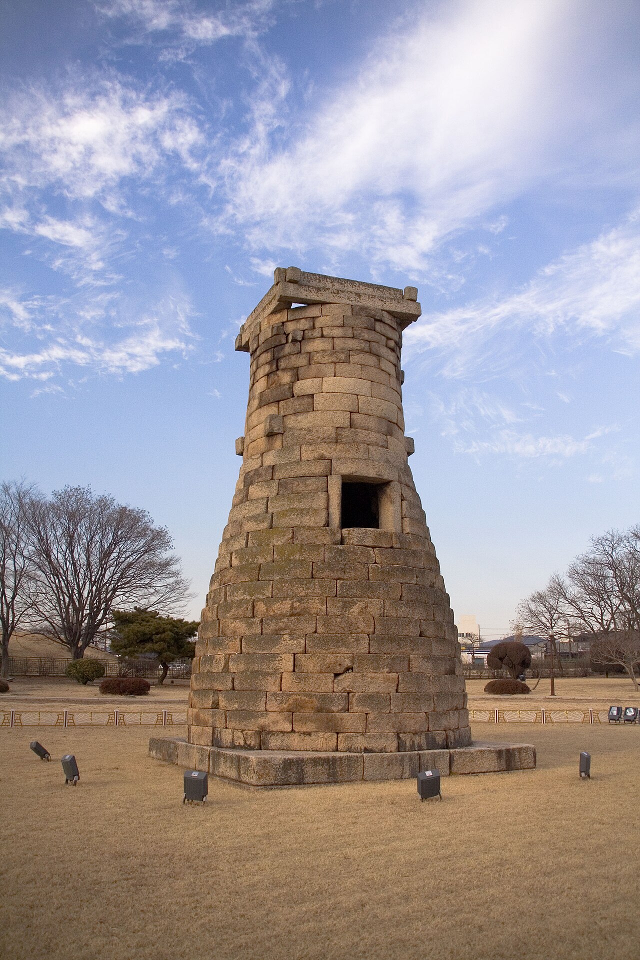
The Gyeongju Historic Areas (경주역사유적지구), inscribed by UNESCO in 2000, preserve the tangible remains of Gyeongju (경주, ancient name Seorabeol), the capital of the Silla Kingdom (57 BCE–935 CE) and the Unified Silla period (668–935 CE) — one of the longest-reigning dynasties in world history at approximately 1,000 years, whose cultural achievements in Buddhist art, astronomy, metalwork, and urban planning make the Gyeongju valley one of the most archaeologically dense sites in Northeast Asia. The inscription covers five distinct heritage zones: the Namsan District (the “Museum Without Walls”, a forested mountain south of the city with 150 Buddhist stone carvings, 57 stone stupas, 64 granite Buddha figures, and 16 royal tombs carved into its hillsides), the Wolseong District (the crescent-shaped earthwork platform of the Silla royal palace Wolseong, and the adjacent Cheomseongdae Observatory — a 362-block granite cylinder 9.4 metres tall, built circa 632–647 CE under Queen Seondeok and the oldest surviving astronomical observatory in East Asia), the Tumuli Park District (Daereungwon, 23 royal burial mounds up to 23 metres in height containing royals buried with gold crowns, bronze vessels, and jade ornaments), the Hwangnyongsa District (the excavated foundation of the 9-storey Hwangnyongsa “Yellow Dragon Temple”, the Silla state’s greatest Buddhist building, burned in 1238 CE by the Mongols), and the Sanseong District (mountain defensive fortresses).
The Gyeongju valley UNESCO cluster and the East Sea coast Seokguram Grotto · Bulguksa Temple · Gameunsa ruins · Donggung Palace — 3 to 30 km
Three Kilometres east of the Tumuli Park in the Gyeongju city centre, the Donggung Palace and Wolji Pond (동궁과 월지, also known as Anapji Pond, 안압지) are the most evocative surviving structures of the Unified Silla royal leisure estate — a man-made pond constructed in 674 CE by King Munmu to serve as the garden lake of the eastern palace complex used for royal banquets and relaxation, excavated in 1974–1975 CE by the National Museum of Korea, which recovered 33,000 objects from the pond’s mud floor including tiles, ceramics, bronze fittings, wooden boats, and a wooden Buddhist board-game set — providing the richest single-site assemblage of Unified Silla material culture recovered in 20th-century Korean archaeology. The pond’s three islands (designed to evoke the Chinese Taoist paradise islands of the Three Immortals) are planted with pine trees, and the three surviving pavilion buildings on the north and east shores (reconstructed in 1975 on original foundations) are reflected in the water at dawn and dusk in a view that is one of Gyeongju’s most frequently photographed. From Tumuli Park, Donggung/Wolji is a 10-minute walk northeast along the Bulgucheon stream; from Donggung, Bulguksa Temple is 12 km east by bus (approximately 30 minutes). The Cheomseongdae Observatory, located 800 metres north of the Tumuli Park, is the Gyeongju inscription’s most structurally unusual component: the 362 granite blocks of its cylindrical body (tapering from a base diameter of 4.93 metres to an opening of 2.85 metres at the top) encode calendrical numbers in their arrangement — 362 blocks correspond to the 362 days of the Silla lunar year, the 12 base blocks at the bottom represent the 12 months, and the internal cross-shaped ledges divide the interior into 4 sections for the 4 seasons. Whether the tower was used for direct stellar observation from the open top (Korean historians debate whether the upper opening is too small for practical observation) or as a gnomon or calendar marker for shadow-based astronomical calculations, the Cheomseongdae represents an extraordinary level of astronomical sophistication in 7th-century CE Korea.
Fifteen Kilometres east of the Gyeongju city centre (approximately 30 minutes by bus to the Seokguram / Bulguksa junction), Mount Toham (토함산) houses both the Seokguram Grotto (석굴암, inscribed UNESCO 1995) and Bulguksa Temple (불국사, inscribed UNESCO 1995), making the Tohamsan-Gyeongju historic area corridor the most concentrated UNESCO heritage zone in Korea: within a 15-km radius, visitors can access five UNESCO properties (Gyeongju Historic Areas + Seokguram + Bulguksa = three inscriptions, plus the shared cultural context of the Unified Silla Buddhist tradition). The Gyeongju National Museum (경주국립박물관), in the Wolseong District approximately 1 km from the Tumuli Park, holds the world’s most complete collection of Silla-period art and artefacts, including the Divine Bell of King Seongdeok (성덕대왕신종, 770 CE, 18.9 tonnes, the largest surviving Silla bronze bell and one of the finest examples of East Asian bronze bell casting — its distinctive bass resonance is described in contemporary accounts as audible from 60 li, approximately 24 km), the gold Silla royal crowns recovered from the Tumuli Park excavations, and the 33,000 objects from the Donggung/Wolji Pond excavation. Gyeongju is directly connected to Seoul by KTX (approximately 2 hours from Seoul Station to Singyeongju Station, then 20 minutes by local bus to Gyeongju city centre).
Practical information
Gyeongju is the most manageable UNESCO city in Korea for self-guided heritage tourism: the central heritage cluster (Tumuli Park, Cheomseongdae, Wolseong fortification earthwork, and Donggung/Wolji) is walkable within a 2 km radius, rental bicycles are available at Gyeongju Station (flat terrain throughout the historic area), and the Gyeongju city heritage bus circuit connects the main sites on a loop route. Tumuli Park (Daereungwon) opens daily 09:00–22:00 (lit at night in summer), admission fee applies; the interior of the two excavated tombs (Cheonmachong and Hwangnamdaechong) is viewable through reproduction-interior exhibits. Cheomseongdae Observatory: open ground access, no admission fee; the tower exterior is viewable at close range. Gyeongju National Museum: Tuesday–Sunday 10:00–18:00, free admission. Bulguksa-Seokguram day-trip: direct buses from Gyeongju Station, approximately 40 minutes each way, standard visiting time 3–4 hours including both sites. The Namsan hiking course (the mountain museum circuit covering Buddhist stone carvings along marked trails on the forested southern mountain) requires a full day (approximately 8 km, 5–7 hours) and is recommended for visitors with strong hiking interest in outdoor Buddhist sculpture. Best visiting season: spring cherry blossom (late March–April, concentrated around the Bomun Lake resort area) and late autumn (October–November, maple foliage on Namsan). The Gyeongju World Culture Expo (held periodically; check current schedule) uses the historic city as a backdrop for large-scale cultural events.
Frequently Asked Questions
What was found inside the Tumuli Park burial mounds and how were they excavated?
The Gyeongju Tumuli Park (대릉원, Daereungwon) contains 23 large earthen burial mounds ranging from 13 to 23 metres in height, all constructed for Silla royalty of the 4th–6th centuries CE using a specific tomb construction technique — the “stone pile tomb” (적석목곽분, jeokseok mogwakbun) — that is unique to Silla culture among East Asian Bronze and Iron Age cultures: a wooden burial chamber (mogwak) was built at ground level, filled with the burial goods and the coffin, then covered with a pile of river stones (to prevent tomb robbing, as the stone collapse would destroy the chamber if disturbed), and finally covered with an earthen mound. The stone-pile technique was devastatingly effective as a tomb protection system: while virtually all Chinese Han-dynasty tombs and Japanese Kofun-period tombs were robbed in antiquity, the Gyeongju stone-pile tombs were too structurally unstable for ancient tomb robbers to tunnel into without triggering collapse, and they survived essentially intact until modern archaeological excavation. The 1973–1975 excavation of Cheonmachong (“Heavenly Horse Tomb”, named for the painted horse discovered inside on a saddle mudguard — the oldest surviving painting on Korean birch bark) yielded 11,526 objects including a gold crown (the “Golden Crown of Cheonmachong”, now in the Gyeongju National Museum, 30.7 cm height, constructed of gold sheet cut into branching tree shapes with dangling gold pendants and comma-shaped jade magatama beads), gold belt with jade pendants, bronze vessels, iron weapons, and horse equipment. The 1973–1975 excavation of Hwangnamdaechong (“Great Mound of the Hwangnam District”, the largest tumulus in the park at 23 metres height and 120 metres in diameter) yielded gold crowns and jewellery from both the male and female burial chambers (the tumulus was a double burial for a king and queen), confirming that Silla royal women were buried with the same quality of gold regalia as their male counterparts.
How long did the Silla Kingdom last and what distinguished it culturally?
The Silla Kingdom’s approximately 1,000-year duration (57 BCE to 935 CE — divided into the Three Kingdoms period, 57 BCE–668 CE, when Silla was one of three competing Korean kingdoms, and the Unified Silla period, 668–935 CE, when Silla controlled the majority of the Korean peninsula after defeating the kingdoms of Baekje and Goguryeo with Tang Chinese military assistance) places it among the longest-surviving royal dynasties in world history, considerably longer than the Roman Empire (27 BCE–476 CE, approximately 500 years in the west), the Byzantine Empire (395–1453 CE, approximately 1,000 years, a close parallel), or the Japanese imperial dynasty (which claims unbroken continuity to the present but with significant periods of ceremonial rather than political authority). Silla’s cultural distinctiveness within the Korean peninsula’s Bronze and Iron Age cultures lies in three areas: its capital Seorabeol (Gyeongju) was planned on a rectangular grid system that is directly analogous to Tang Chinese city planning (the Tang capital Chang’an, modern Xi’an, was the direct model, though Seorabeol’s grid was adapted to the Gyeongju valley’s topography), making it one of the earliest planned-grid capitals in Korea; its Buddhist art reached a technical sophistication in stone carving and bronze casting (the Seokguram granite Buddha, the Divine Bell of Seongdeok, the stone pagodas of Bulguksa) that is without parallel in contemporary East Asian Buddhist production outside Tang China itself; and the Silla royal court produced the Three Kingdoms’ only known independent astronomical observatory (Cheomseongdae) and several mathematical and astronomical texts documenting a systematic engagement with celestial observation. The Unified Silla period’s cosmopolitan quality — Korean Buddhist monks travelling to Tang China, India, and Central Asia for texts and training, bringing back Sanskrit manuscripts, Indian iconographic traditions, and Central Asian musical instruments — produced a cultural synthesis at Gyeongju that is the direct parent of later Korean literary, artistic, and religious traditions.
What happened to the Hwangnyongsa Temple and why is its site still significant?
Hwangnyongsa (황룡사, “Temple of the Yellow Dragon”, founded 553 CE by Silla King Jinheung on a site where a yellow dragon was reported to have appeared during the construction of a new palace — a prodigious omen that persuaded the king to convert the palace foundation into a temple), was the largest Buddhist temple ever constructed in Korea: the main hall (Jangyuk-jon, “Hall of the One-Zhang-Six-Chi Buddha”) housed a 16-foot gilt bronze Buddha cast in 574 CE, the main courtyard covered 32,520 square metres (the largest roofed courtyard in Korean architectural history), and the 9-storey wooden pagoda was reportedly 225 Korean feet (approximately 80 metres) in height — if the estimate is accurate, the Hwangnyongsa pagoda was the tallest wooden structure in East Asia during the Silla period and one of the tallest pre-modern wooden structures in world history (comparable to Cologne Cathedral or St. Paul’s Cathedral in height). The Mongol invasion of 1238 CE burned Hwangnyongsa and its pagoda to the ground during a 16-day fire that contemporary Korean accounts describe as destroying the entire temple complex and collapsing the pagoda. The foundations were never rebuilt — unlike most other Korean Buddhist temples, which were reconstructed after Mongol destruction, Hwangnyongsa was left as an open field (the Joseon dynasty’s Confucian state de-emphasised Buddhist restoration projects). The 1976–1983 and subsequent archaeological excavations have fully mapped the foundation plan of the main hall, the pagoda, and the subsidiary buildings, and the Hwangnyongsa Heritage Foundation established in 2015 has developed a long-term restoration plan; as of 2024, the excavated foundation plan is visible as an open archaeological landscape with scale markers indicating the original building dimensions. A virtual reconstruction of the Hwangnyongsa pagoda using 3D visualisation technology is available at the Gyeongju National Museum and at the Hwangnyongsa Site Museum (open for limited public access during the archaeological season).
Sources
- S1 — UNESCO World Heritage Centre — Gyeongju Historic Areas (Ref. 972) — https://web.archive.org/web/20230601000000/https://whc.unesco.org/en/list/972/
- S2 — UNESCO World Heritage Centre — Statement of Outstanding Universal Value (Ref. 972) — https://whc.unesco.org/en/list/972/
Spotted an error? Write to editorial@culturalheritageonline.com and we correct it the same day.