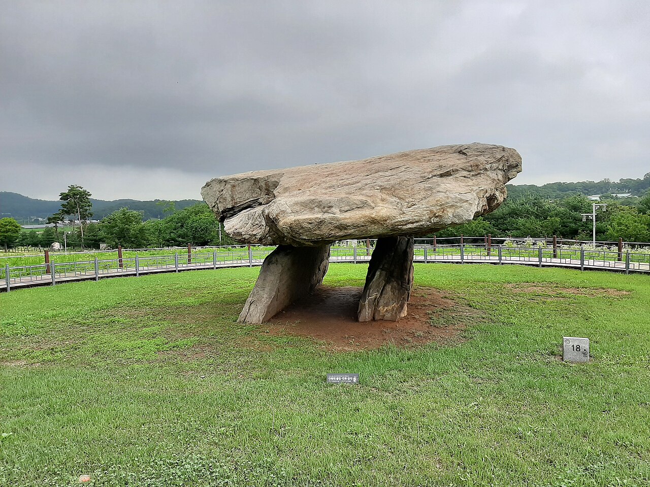
The Gochang, Hwasun and Ganghwa Dolmen Sites, inscribed by UNESCO in 2000, preserve three clusters of prehistoric megalithic burial monuments on the Korean peninsula — Gochang (고창, 447 dolmens, North Jeolla Province), Hwasun (화순, 158 dolmens, South Jeolla Province), and Ganghwa (강화, 120 dolmens, Incheon Metropolitan City) — constituting the world’s highest concentration of dolmen monuments and representing approximately 40 percent of all known dolmens worldwide, which places Korea in a globally unique position as the primary landscape for this megalithic burial tradition. The inscription’s Outstanding Universal Value rests on the sites’ collective documentation of a Bronze Age (approximately 1000–300 BCE) culture that invested enormous collective labour in constructing giant stone monuments as burial markers for elite individuals, mobilising communities of hundreds for the quarrying, transport, and erection of capstones weighing between 30 and 280 tonnes — with the Ganghwa Island Bugeun-ri dolmen (부근리 고인돌), the largest surviving Korean dolmen, resting a 6.4 × 5.3-metre capstone (estimated weight 280 tonnes) on two upright support stones 2.6 metres in height, in a northern-style table dolmen form whose scale has no equivalent outside Korea.
From the Jeolla dolmen landscape to the western coast and Incheon Gochang Fortress · Hwasun Hot Springs · Ganghwa Island — 150 to 400 km
The three inscription components are geographically dispersed along Korea’s western and southwestern coast, making a single itinerary covering all three a multi-day journey. The Gochang dolmen cluster (고창 고인돌 유적) is located in North Jeolla Province, approximately 3 hours south of Seoul by bus (via the Honam Expressway) or 2 hours by KTX to Jeongeup Station and then bus to Gochang. The Gochang dolmen site (comprising 447 dolmens in five clusters along the forested slopes of the Dosan Stream valley, with the dolmens visible along a marked walking trail through mixed forest) is adjacent to the Gochang Dolmen Museum (고창 고인돌 유적 박물관), which provides the most comprehensive English-language interpretation of dolmen construction techniques and the Bronze Age communities that built them. Nearby Gochang Fortress (고창읍성 Moyang Castle, a 15th-century CE Joseon-period stone fortress encircling the old Gochang town centre, with an annual “Fortress Walking Festival” in October) and the Seonunsa Temple (선운사, a 6th-century CE Buddhist temple in the Seonunsan Provincial Park, approximately 15 km northeast of Gochang, famous for its spring camellia and autumn maple) provide regional heritage context. The Hwasun dolmen cluster (화순 고인돌 유적), approximately 40 km east of Gwangju City, includes the Boan-ri and Doam-ri dolmen areas along a forested gorge where the original quarrying sites are visible — the Hwasun sites are the most geologically informative because the quarry from which the capstone blocks were cut can be identified and the unfinished stones still partially in the quarry face can be examined, providing direct evidence of the extraction and transport methods. From Gwangju (광주광역시, the regional capital of South Jeolla, connected to Seoul by KTX in approximately 1.5 hours), buses to Hwasun run approximately every 30 minutes.
The Ganghwa Island dolmen cluster (강화 고인돌 유적) on Ganghwa Island, approximately 50 km west of Seoul in the Han River estuary (accessible from Seoul by bus from Sinchon Station, approximately 80 minutes), contains 120 dolmens and is the most archaeologically and historically layered of the three sites — Ganghwa Island has been inhabited continuously since the Neolithic period, served as the Goryeo dynasty’s wartime capital during the Mongol invasions (1231–1270 CE), contains the Jongmyo-equivalent of the Joseon royal family in the form of the three Joseon-period royal mausoleums (릉), and was the site of significant battles in the French Punitive Expedition (1866 CE), the American military expedition (1871 CE), and the Japanese gunboat incident (1875 CE) that led directly to the opening of Korea to foreign trade. The Ganghwa island dolmen landscape is thus an accretional heritage site in which the Bronze Age megalithic tradition is layered beneath 3,000 years of additional history. The Bugeun-ri table dolmen (the largest individual dolmen in the inscription) is on a hillside in the centre of Ganghwa Island, approximately 25 km from Ganghwa Town and accessible by rural bus; it is the most impressive single dolmen in the Korean inscription and the one most commonly illustrated in UNESCO publications. Combined with Ganghwa Town’s Goryeo Palace Site (고려궁지) and the Jeondeungsa Temple (전등사, founded 4th century CE, the oldest continuously operating Buddhist temple on Ganghwa Island), Ganghwa Island constitutes a half-day to full-day heritage circuit from Seoul.
Practical information
The three dolmen clusters require separate visits as they are not geographically proximate. For visitors based in Seoul: the Ganghwa dolmen cluster is the most accessible (bus from Sinchon, approximately 80 minutes; the Bugeun-ri table dolmen is approximately 25 km from Ganghwa Town bus terminal, accessible by local bus or taxi). For visitors on a southern Korea circuit: Gochang and Hwasun can be combined in a 2-day Jeolla Province tour, with Gochang (1 day) → Hwasun via Gwangju (1 day). The Gochang Dolmen Museum (open Tuesday–Sunday, closed Monday) provides the best interpretive context for all three dolmen clusters and is recommended as the starting point for Gochang visitors. At Hwasun, the dolmens are visible along a marked walking trail through a forested gorge (approximately 2 hours walk) with the quarry faces accessible; no museum on-site, but information boards in Korean and English mark the key dolmens. The Ganghwa dolmens are on a self-guided trail around the Bugeun-ri site with information boards (English available). None of the three sites charges admission (free access to the dolmen landscape). Best visiting season: spring (March–May, wildflowers on the Gochang trail, clear visibility on Ganghwa Island) and autumn (October–November, deciduous foliage at Hwasun’s forested gorge). The dolmens are not affected by weather conditions, making them suitable year-round. All three sites are UNESCO World Heritage, but they are managed by separate local authorities (Gochang County, Hwasun County, Incheon Metropolitan City) with different visiting infrastructure.
Frequently Asked Questions
How were Korean dolmens built and what did they mark?
Korean dolmens (고인돌, “supported stone” in Korean, a descriptor of the table-type dolmen’s visible form) were built as funerary monuments for elite individuals in a Bronze Age society (approximately 1000–300 BCE) characterised by social stratification and the emergence of chiefdom-level political authority. The construction process required organisation at the scale of a mobilised community rather than a single household: the largest capstones (weighing 100–280 tonnes) required the coordinated effort of hundreds of workers for quarrying (using fire and water to fracture the granite), sledge transport (wood rollers laid on clay tracks to reduce friction), and erection (raising the capstone onto support stones by progressive levering and packing). Experimental archaeology studies conducted by the Korean Cultural Heritage Administration in the 1990s estimated that the erection of a 40-tonne dolmen required approximately 500 worker-days; the 280-tonne Bugeun-ri capstone would have required a proportionally larger labour force and several months of construction time. The cultural meaning of dolmen construction as a social process — the mobilisation of community labour for a single funerary monument — indicates that dolmen builders occupied a position of authority sufficient to command large-scale collective work, placing them in the upper stratum of Bronze Age Korean social organisation. The burial under the dolmen typically contains a stone cist (a box-like burial chamber of flat stones set edge-to-edge under or adjacent to the capstone) holding a single adult individual with bronze grave goods (daggers, mirrors, bronze buttons) indicating high status. Korean dolmens are found across the peninsula from the Liao River basin in the north (now China’s Liaoning Province) to Jeju Island in the south — a geographic distribution that suggests a shared megalithic culture extending across the Korean cultural sphere of the Bronze Age, and that the southern Jeolla Province concentration (the world’s highest density) reflects a later regional intensification of the tradition rather than its geographic origin.
Why does Korea have 40% of all the world’s dolmens?
The Korean peninsula’s extraordinary concentration of dolmens (approximately 30,000–40,000 surviving dolmens in South Korea and North Korea combined, out of an estimated global total of approximately 75,000–85,000 dolmens in all regions) reflects a combination of geographic, geological, and cultural factors that produced a uniquely persistent and regionally bounded megalithic tradition. The geological factor is significant: the Korean peninsula is largely underlain by granite (a coarse-grained, hard, erosion-resistant rock), and granite’s natural jointing pattern (parallel fractures produced by cooling of the original magma) makes it relatively easy to quarry large flat slabs by driving wedges into natural joints — the same jointing that makes Gyeonggi and Jeolla province granite ideal for capstone quarrying. European megalithic builders working in limestone or sandstone faced different geological constraints that produced different monument forms (standing stones, stone circles, passage graves) rather than the flat-capstone dolmen form that granite’s natural splitting pattern facilitates. The cultural factor is the duration and intensity of the dolmen-building period in Korea: the Korean Bronze Age dolmen tradition continued for approximately 700–800 years (roughly 1000–300 BCE), much longer than the megalithic periods in western Europe (which peaked in 4000–3000 BCE and tapered off with the adoption of agriculture and metal technology), and the Korean tradition shows progressive elaboration over time rather than decline — later dolmens in the Jeolla Province clusters are larger, more numerous, and more standardised in form than earlier examples, suggesting a tradition that intensified as the Bronze Age social stratification deepened. The comparative rarity of large dolmens outside Korea (dolmens exist in parts of France, Ireland, England, India, Indonesia, and the Middle East, but nowhere in the density or scale seen in Korea) may reflect the fact that Korea’s flat agricultural lowlands surrounded by granite highlands provided the optimal combination of suitable stone, flat transport terrain, and a dense agricultural population capable of mobilising large numbers of workers for monument construction.
What is the connection between the Ganghwa Island dolmens and later Korean history?
Ganghwa Island’s prehistoric dolmen landscape is overlaid by one of the most strategically significant locations in Korean history: a tidal island in the Han River estuary controlling the approach to Seoul by sea, used as a defensive refuge by the Goryeo dynasty (918–1392 CE) during the Mongol invasions and as a trading and military checkpoint for every foreign power that attempted access to the Korean interior in the 19th century. The Bronze Age dolmen builders’ choice of Ganghwa as a concentration site reflects the island’s same strategic advantages that made it significant in later periods: it is the largest island in the Han estuary, its surrounding mudflat tidal zones are difficult to navigate without local knowledge, its elevated central terrain (Manisan, 469 m) provides long-range visibility of all approaches, and the freshwater sources on the island (streams fed by Manisan’s springs) support a permanent agricultural population. The Goryeo court’s use of Ganghwa as a wartime capital (1231–1270 CE, during the Mongol invasions that destroyed mainland Korean cities including the original Haeinsa) brought the island into Korean dynastic history, and the 19th-century foreign military incursions — the French Punitive Expedition (1866, following the execution of French missionaries) and the American Expedition (1871, in response to the killing of American sailors from the USS Sherman schooner) — both landed on Ganghwa Island and fought battles at the Gwangseongjin and Deokjinjin coastal fortresses, whose ruins (now partially restored) still stand on the island’s western coast. The 1875 Japanese gunboat Unyo’s provocation at Ganghwa’s Yeongjong Island forced the 1876 Ganghwa Treaty (강화도 조약) that opened Korean ports to Japanese trade — a direct precursor to the 1910 annexation. The dolmens remain on the island’s hilltops above all this historical accumulation, among the oldest human constructions still in situ in the Han River estuary.
Sources
- S1 — UNESCO World Heritage Centre — Gochang, Hwasun and Ganghwa Dolmen Sites (Ref. 977) — https://web.archive.org/web/20230601000000/https://whc.unesco.org/en/list/977/
- S2 — UNESCO World Heritage Centre — Statement of Outstanding Universal Value (Ref. 977) — https://whc.unesco.org/en/list/977/
Spotted an error? Write to editorial@culturalheritageonline.com and we correct it the same day.