
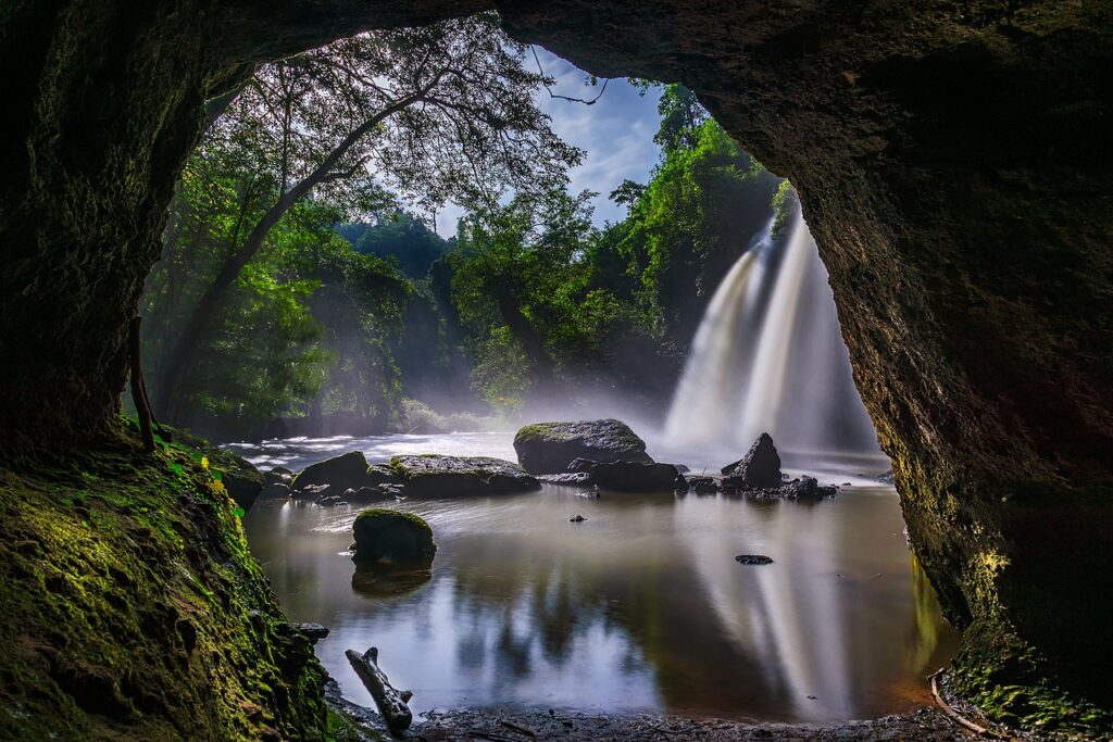
The Dong Phayayen-Khao Yai Forest Complex (ดงพญาเย็น–เขาใหญ่), inscribed by UNESCO in 2005, is a serial World Heritage site encompassing five interconnected protected areas — Khao Yai National Park (UNESCO 1992, extended to include the full complex in 2005), Thap Lan National Park, Pang Sida National Park, Ta Phraya National Park, and Dong Yai Wildlife Sanctuary — spanning approximately 6,155 km² of forest across the transition zone between the Khorat Plateau (northeast Thailand) and the central lowlands of Thailand, approximately 100–200 km northeast of Bangkok. The forest complex represents the largest surviving block of seasonal tropical forest in the eastern forest corridor of Thailand — a counterpart to the Thungyai-Huai Kha Khaeng complex of the western forest corridor, forming together the two main pillars of Thailand’s forest conservation system. The complex supports a significant wildlife assemblage including Indochinese tiger, Asian elephant, Indochinese leopard, gaur, banteng, Asiatic black bear, sambar deer, and approximately 392 bird species (including four hornbill species — the Great Hornbill, Wreathed Hornbill, Oriental Pied Hornbill, and Rufous-necked Hornbill — whose large size and specialist old-growth forest requirements make them flagship indicators of forest quality). Khao Yai National Park (the accessible core of the complex, established in 1962 as Thailand’s first national park) is the most visited national park in Thailand and one of the most visited in Asia, with approximately 1–2 million visitors per year, driven by its combination of accessible wildlife viewing (Asian elephants, hornbills, gibbons, and sambar deer are regularly visible along the park roads and waterfalls), dramatic scenery (the plateau-edge waterfalls including the 25-metre Haew Suwat waterfall, which was a filming location for the 2000 film “The Beach”), and proximity to Bangkok (approximately 200 km — 3 hours by road).
Khao Yai’s accessible wildlife and the northeast Thailand heritage corridor Haew Suwat Waterfall · Khao Yai wildlife roads · Pak Chong · Bangkok — 0 to 200 km
Khao Yai National Park’s specific character within the Dong Phayayen complex is determined by its position on the edge of the Khorat Plateau — the park is built around the plateau escarpment where the plateau surface drops sharply from approximately 700–1,000 m above sea level to the Bangkok plain at approximately 50–100 m, creating the dramatic waterfalls and mixed vegetation gradients (from lowland evergreen forest at the base of the escarpment to montane grassland at the plateau summit) that give the park its scenic variety. The wildlife viewing in Khao Yai concentrates on: the main paved road through the park’s plateau grassland section (night drives with rangers, where sambar deer, civets, porcupines, and occasionally elephants are seen); the Haew Narok waterfall area (80-metre-high, the largest waterfall in the park, where gibbons and hornbills are regularly seen in the surrounding trees); and the Haew Suwat waterfall (25 metres, accessible on foot through forest, where great hornbills and gibbons are commonly seen). The four hornbill species of Khao Yai are the primary specialist attraction — hornbills are considered charismatic megafauna among birders and general wildlife visitors in Southeast Asia, and the Khao Yai population (particularly the Great Hornbill, with its distinctive yellow-and-black casque, approximately 1.2 m body length, and loud wing-beat sound audible at 200 metres) is one of the most reliably observable of any hornbill population in Thailand. The broader Dong Phayayen complex outside Khao Yai (Thap Lan, Pang Sida, Ta Phraya, and Dong Yai) is less visited but ecologically critical — these areas form the connectivity between Khao Yai and the Cambodian/Lao border forests to the northeast, providing the wildlife corridors that allow genetic exchange between the Thai and Cambodian tiger and elephant populations.
Practical information
Khao Yai National Park is approximately 200 km (3 hours by road from Bangkok) north-northeast of Bangkok via Highway 1 to Nakhon Ratchasima (Korat) and then Highway 2 south to the Pak Chong junction. Access: by bus from Bangkok Chatuchak (Mo Chit) bus station to Pak Chong (approximately 2.5 hours), then songthaew from Pak Chong to the park entrance. Tour operators in Pak Chong offer day-trip and overnight wildlife programmes with night drives and guide services (strongly recommended for first-time visitors — wildlife spotting in the park is dramatically better with an experienced guide who knows the current animal locations and animal behaviour patterns). The park is open daily 06:00–18:00 (with permitted overnight stays at campsite and guesthouses inside the park, which allow night-time wildlife watching). Park entrance fee applies (significant for foreigners; Thai national price lower). Accommodation: National Park guesthouses inside the park (limited availability, advance booking essential for weekends and holidays), plus numerous private resorts and hotels outside the park entrance area in the Pak Chong district. The Khao Yai area has become a weekend resort destination for Bangkok residents, so accommodation quality is considerably higher than a typical Thai national park — several boutique hotels and wine resorts operate in the farmland area outside the park boundary. Best visiting months: November–February (dry season, vegetation open, wildlife concentrates at water sources, cooler temperatures); June–October (monsoon, waterfalls at full flow, leeches on trails, but forest is spectacularly green).
Frequently Asked Questions
Why was Dong Phayayen-Khao Yai Forest Complex inscribed as a UNESCO World Heritage site?
The Dong Phayayen-Khao Yai Forest Complex was inscribed by UNESCO in 2005 under criteria (ix) and (x) — the criteria for outstanding universal value in natural sites that specifically address: (ix) “outstanding examples representing significant ongoing ecological and biological processes in the evolution and development of terrestrial, fresh water, coastal and marine ecosystems and communities of plants and animals”; and (x) “the most important and significant natural habitats for in-situ conservation of biological diversity, including those containing threatened species of outstanding universal value from the point of view of science or conservation”. The specific justifications submitted in the UNESCO nomination dossier were: the forest complex represents the largest remaining monsoon-forest block in the Eastern Forest Complex of Thailand (the lowland and mid-elevation forest corridor of the central and northeast transition zone), an ecosystem type that has been almost entirely converted to agriculture elsewhere in the lower Chao Phraya and Mun-Chi river systems; the complex contains the most significant populations of globally threatened species in the eastern part of the Thai-Myanmar-Lao-Cambodian “biodiversity hotspot” region — including approximately 40–50 tigers (at the time of inscription; subsequent camera-trap surveys suggested the actual number was lower), approximately 300–400 Asian elephants, and the only known breeding population of Eld’s deer (Cervus eldi siamensis, the “thamin” — a Critically Endangered deer species endemic to mainland Southeast Asia, with the global population reduced to approximately 1,000–2,000 individuals in the wild). The specific challenge in the inscription process was the political pressure from golf course development at the edge of Khao Yai National Park — the park boundary areas had been encroached upon by resort developments in the 1990s and early 2000s, and the UNESCO inscription process required the Thai government to commit to boundary protection and buffer zone management that would prevent further encroachment. The UNESCO World Heritage status has since been used by Thai conservation organisations as a legal and diplomatic lever to resist development proposals in the park buffer zone.
What are hornbills and why are they considered indicators of old-growth forest quality?
Hornbills (family Bucerotidae) are a family of tropical birds distributed across sub-Saharan Africa and Asia, characterised by their large size, distinctive curved bills, and the prominent bony casque that grows on the upper bill of many species (the function of the casque varies by species — in the Great Hornbill Buceros bicornis it appears to be a secondary sexual characteristic used in competition and mate selection; in the Helmeted Hornbill Rhinoplax vigil of Borneo and Sumatra the casque is solid ivory-like keratin and is the target of illegal wildlife trade). The four hornbill species of the Dong Phayayen-Khao Yai complex are: the Great Hornbill (Buceros bicornis, the largest Asian hornbill, with a wingspan up to 150 cm — globally Vulnerable, decreasing); the Wreathed Hornbill (Rhyticeros undulatus, the second largest, with a wrinkled casque and white tail — globally Least Concern but locally declining); the Oriental Pied Hornbill (Anthracoceros albirostris, the smallest of the Khao Yai species, black and white, relatively adaptable to forest edge — Least Concern); and the Rufous-necked Hornbill (Aceros nipalensis, a Vulnerable species of montane evergreen forest). Hornbills are indicator species for old-growth forest quality for a specific biological reason: they are “large-frugivore obligates” — they require old-growth forest trees with large figs and other large fruit species to maintain their populations, and they nest exclusively in large natural tree cavities in old-growth trees (the typical nesting tree for a Great Hornbill is a tree ≥50 cm diameter at breast height with a cavity large enough for the female to seal herself inside with the eggs and chicks during the incubation period of approximately 4 months — a requirement that means hornbills cannot survive in forests that have been logged of their large-diameter old trees). The presence of hornbills thus directly indicates the presence of a sufficient density of very large old trees — which in turn indicates forest that has not been commercially logged in at least several decades. In the Dong Phayayen-Khao Yai complex, where the old-growth forest of the plateau interior has been protected since 1962 (Khao Yai’s establishment as Thailand’s first national park), the hornbill population is one of the most stable and observable in Southeast Asia, making Khao Yai one of the best sites on the continent for hornbill viewing.
EXCERPT: Dong Phayayen-Khao Yai Forest Complex, UNESCO-inscribed 2005 (five linked protected areas, 6,155 km²), is the largest eastern forest block of Thailand — Asian elephants crossing park roads at dusk, four hornbill species in the old-growth canopy, the Haew Suwat waterfall, and Thailand’s most visited national park (Khao Yai) 3 hours from Bangkok.
META: UNESCO World Heritage Sites near Dong Phayayen-Khao Yai Forest Complex Thailand: Thungyai-Huai Kha Khaeng 300 km west (UNESCO 1991), Kaeng Krachan Forest Complex 300 km southwest (UNESCO 2021), Historic City of Ayutthaya 200 km west (UNESCO 1991) — Khao Yai National Park Bangkok weekend trip hornbill elephant tiger, Dong Phayayen UNESCO Thailand, Pak Chong Haew Suwat waterfall Khorat Plateau wildlife.
Sources
- S1 — UNESCO World Heritage Centre — Dong Phayayen-Khao Yai Forest Complex (Ref. 590) — https://web.archive.org/web/20230601000000/https://whc.unesco.org/en/list/590/
- S2 — UNESCO World Heritage Centre — Statement of Outstanding Universal Value (Ref. 590) — https://whc.unesco.org/en/list/590/
Spotted an error? Write to the editors and we correct it the same day.