
Partner ContentContent published in partnership with Paola Bonometti.
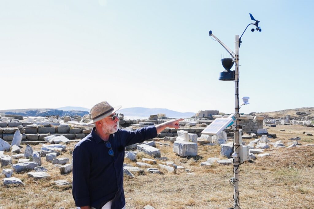
There is no grid on Delos, no lodging, and no resident community to notice when an instrument stops reporting. The ARGUS project built a wind monitor for that situation, and this is what it took. Published as part of the ARGUS dissemination programme, which is led by Kneia.
An island the grid does not reach
Delos measures five kilometres from north to south and a little over one from east to west, lying between Mykonos and Rheneia in the Cyclades. It was inscribed on the UNESCO World Heritage List in 1990 under criteria (ii), (iii), (iv) and (vi), over a property of 350.64 hectares. The island has been abandoned since the sixth century, and its landscape is a field of ruins unearthed since 1872. When ICOMOS assessed the nomination in 1989 it asked Greece to keep guided day tours and to continue excluding any lodging on the island.
The ARGUS project describes Delos and Monti Lucretili as its fully off-grid sites: instruments there run on long-duration batteries and solar panels, and report over LoRaWAN. In its own risk assessment the project names the threats on Delos as ultraviolet radiation and salt-laden humidity, the pair it holds responsible for surface erosion and pigment fading.

Why wind counts as a conservation measurement
ARGUS works by mapping threats onto sensors, not by buying a standard weather station. The method has four stages: identify the degradation threats at a site, rank them, match each to a physical quantity that can stand in for it, and only then model where a device can be installed. Wind enters at the third stage. In the project’s own selection criteria, an anemometer is justified because wind speed “might translate into erosion and/or movement of built elements”.
The wind node is one of several instruments planned for the island. The deployment matrix for Delos also lists temperature and humidity probes, UV and lux sensors, air quality modules, multispectral imaging, tiltmeters and GNSS, and human-presence detection. One rule governs all of them: every device touching a heritage surface must be non-invasive or reversible, and installations must satisfy conservation ethics.
Two prototypes, and the one that went to the island
The first version was built around low air movement. It uses an Arduino MKR WAN 1310 board and four Omron D6F-V03A1 airflow sensors, each facing one of the cardinal points, and it measures up to 10 km/h.
The second version keeps the board, changes the sensors. It carries four Renesas FS3000-1015 airflow sensors, which work on a MEMS thermopile element and give a digital output at 12-bit resolution, extending the range to 54 km/h. The four sensors sit in different orientations, and the differences between their readings are what allow direction to be estimated. A Sensirion SHT35 adds temperature and humidity, so the wind figure arrives with the conditions that produced it.
Two details make the instrument deployable rather than merely interesting. The first is communication: the MKR WAN 1310 has LoRaWAN built in, so the node needs no local network.
The second is power: a later version was fitted with a solar panel, so it needs no external supply at all. The enclosure of the second version was 3D printed, and the project describes the same housing problem elsewhere in terms that apply here too: a custom case designed in Autodesk Inventor and made by additive manufacturing against three criteria, that it function, protect the electronics and be installed without invading the structure.

Two of these units were built and deployed, to two very different places: one to Delos, and one to the Abbey of Sant’Antonio di Ranverso near Turin, where rising damp and water infiltration are the threats the project set out to watch.
Nothing may be drilled
On an archaeological site the mounting is the hard part. The project reports that on Delos the sensor mounts had to be entirely non-invasive because of the site’s archaeological character, and that custom brackets and adhesive-free anchoring were developed with preservation experts for the purpose.
The authority that protects the site is also inside the project: the Ephorate of Antiquities of the Cyclades, the regional office of the Greek Ministry of Culture responsible for the Delos archaeological site, is an ARGUS partner. That does not remove the constraint. It means the constraint is negotiated as engineering, in the bracket and the housing, rather than afterwards as a permission.

What the instrument measured, and against what
A cheap sensor is not automatically a right one, so the prototype was checked against a commercial calibrated unit: the SenseCAP S2120, an eight-in-one LoRaWAN weather station that also runs on solar and batteries. Over the comparison, and as the authors report, the MEMS anemometer tracked the commercial station’s wind speed closely, with a temporal correlation of R = 0.904.
Direction was harder. The authors report good agreement in the general trend and, in the same paragraph, higher noise and reduced stability, concluding that filtering or averaging would improve it.
That weakness sits in the paper, not in a footnote. For a heritage manager deciding whether to trust a cheap node, the useful figure is not the one that flatters the prototype but the one that says where it should not be relied on yet.
The part that has to work with nobody on the island
During development, readings went to ThingSpeak for quick visualisation. The operational deployment sends them to the cloud platform of Worldsensing, a project partner, with LoRaWAN gateways forwarding packets over a 4G backhaul. On a site with no permanent inhabitants, autonomy is not a convenience. It is the design.

The project’s report on its deployable sensor packages is direct about what that costs. Across the five pilot sites the teams met vandalism, power outages, and conditions of high humidity and salinity that occasionally caused systems to fail. Those failures fed back into power management and robustness. This is the ordinary weather of field instrumentation, and much of why the installation is worth describing.
What the site’s conservator takes from it
Christos Maris, Conservator of Antiquities at the Ephorate of Antiquities of the Cyclades, puts the value of the work in the size of the problem. Delos is vast, exposed and difficult to watch. Remote monitoring, environmental data, measurements taken on the ground, sensors, satellite observation and drone survey each cover a part of it, and what the project does is bring them together into one reading of how environmental pressure is acting on the archaeological landscape.
The shift he points to is one of timing. Conservation has long recorded deterioration after it happened; this makes it possible to see a change while it is still small, early enough to act on it. Archaeologists, researchers and the authority that protects the site work inside the same project, which is what turns separate streams of data into something a conservator can use.
Summary supplied by KNEIA S.L., dissemination partner of the ARGUS consortium.
What is still open
The published results are the initial validation phase. Long-term campaigns at the five pilot sites are still running and will produce larger datasets, which the project expects to use for predictive maintenance and AI-assisted analysis. ARGUS closes on 30 November 2026: by then the framework will have been tested at five sites in four countries, across more than ten environmental and anthropogenic variables.
Delos is the case that explains why the work was framed as it was. On an inhabited site, monitoring competes with instruments that already exist nearby. On an uninhabited one, with no power and nothing that may be drilled, the alternative to a node like this is no measurement at all.
Questions this article answers
A wind monitor built by the ARGUS project on the archaeological site: four airflow sensors on a single board, in a 3D-printed case, on a solar panel.
It does not use the grid. An internal long-duration battery and a solar panel keep it running, and LoRaWAN carries the readings off the island.
Because wind speed is a proxy for a conservation risk. It can translate into erosion and the movement of built elements, and on Delos it adds to ultraviolet radiation and salt-laden humidity.
Yes, against a commercial calibrated LoRaWAN weather station, the SenseCAP S2120. Wind speed tracked it closely, at R = 0.904. Wind direction was less stable.
No. The mounts on Delos had to be entirely non-invasive, so custom brackets and adhesive-free anchoring were developed with preservation experts.
Sources
- S1 — Hellenic Ministry of Culture and Sports — Archaeological Site of Delos Monument Protection Portal — http://odysseus.culture.gr/
- S3 — Photographs of the installation on Delos supplied by KNEIA S.L., dissemination partner of the ARGUS consortium, October 2026
- S2 — Philippe Bruneau & Jean Ducat — Guide de Délos, École française d'Athènes / De Boccard, Paris, 2005, ISBN 978-2869582040
Spotted an error? Write to the editors and we correct it the same day.