
Three days from the crater of Nea Kameni to the Bronze Age city buried under ash at Akrotiri, and up to the villages on the rim of the caldera that the eruption left behind.
An island shaped by one bad afternoon
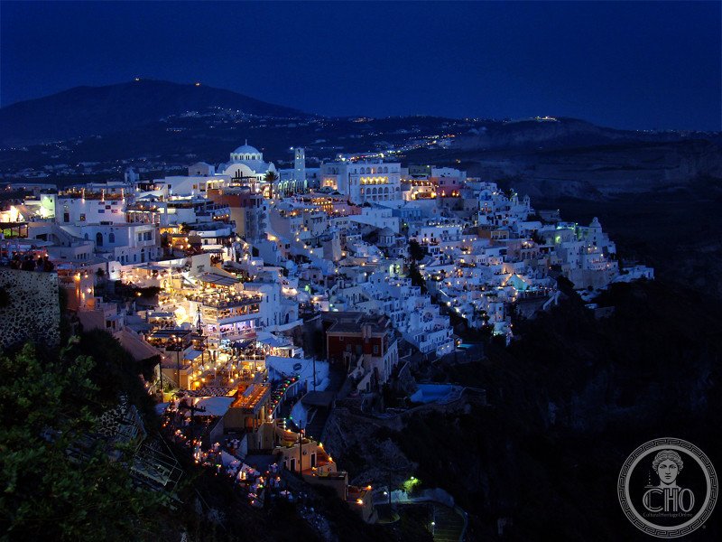
Around 1600 BC the volcano under Santorini erupted with a force that sent a tsunami across the eastern Mediterranean and collapsed the centre of the island into the sea. The Minoan town of Akrotiri, a few kilometres south, was buried under metres of ash and pumice and stayed that way for three and a half thousand years. What tourists photograph today — the white cubes on the cliff, the blue domes, the terraces — is architecture built on the rim of that hole, and rebuilt after the earthquake of 1956 that flattened most of it.
The route is not a walking itinerary: the island is 26 kilometres from Oia in the north to Akrotiri in the south, and the buses are frequent and cheap. Three days is enough to see the geology, the archaeology and the villages in the right order, which is the order in which they happened.
Day one: the crater and the capital
Start in Nea Kameni, the black island in the middle of the caldera, two kilometres from the port of Fira. Boats run from the old port; you land on a concrete jetty and walk up through lava fields to the rim. The ground is warm in places and the sulphur vents still smell of the volcano. Nea Kameni emerged from the sea in 1707 and has been growing ever since: eruptions in 1866, 1925–26, 1928, 1939–41 and 1950, the last one the most recent activity on the island. The 1926 eruption destroyed villages on the rim.
Back on land, Fira is the capital and the practical base. It sits on the caldera edge above the port of Skala Fira, connected to the water by a stepped path with donkeys and, since 1979, a cable car. The town was rebuilt after the 1956 Amorgos earthquake, and the reconstruction is what produced the look that has been copied all over the Mediterranean since: whitewash, small windows, churches with blue domes, terraces cut into the pumice. The name Santorini comes from the Venetian Santa Irini; the island’s formal Greek name, Thira, comes from the Dorian city founded on Mesa Vouno in the ninth century BC.

Day two: the city under the ash
Akrotiri is the reason to come in spring rather than August. The settlement was a major Aegean port by the middle of the second millennium BC, trading with Crete, mainland Greece, Egypt and the Levant. Its houses were multi-storey, its streets paved, its drainage system carried hot and cold water and served indoor toilets — a level of plumbing that Europe would not see again for more than a thousand years. The frescoes on the walls are among the best preserved of the Bronze Age. No human remains have been found: the population left before the eruption, taking what they could carry.
Spyridon Marinatos began excavating in 1967, and the work continues; only a fraction of the city has been uncovered. The site is roofed, which makes it visitable in any weather, and the material that buried it is still visible all around: metres of tephra, the same layer that appears in cores across the eastern Mediterranean and dates the eruption.
The two beaches, which are geology lessons
Five hundred metres from Akrotiri, Red Beach is a hundred metres of shoreline under cliffs that rise sixty metres in places, stained red and rust by iron oxide that formed when molten rock met the air. The sand is crushed red volcanic rock mixed with dark basalt. On the other side of the island, Perissa is black sand — basalt fragments cooled fast in seawater — running for seven kilometres south to Perivolos and Agios Georgios, sheltered from the wind by the mass of Mesa Vouno. That mountain, 369 metres above the beach, holds the ruins of Ancient Thera, the Dorian city founded in the ninth century BC by colonists from Sparta under Theras. It is a steep walk or a short drive from the beach, and the view from the top explains the whole geography at once.

Day three: Oia and the sunset
Oia sits at the northern end of the caldera, built into the cliff in the Cycladic way: small windows, cave houses carved from pumice, sea captains’ houses from the post-Ottoman maritime trade. The village was largely rebuilt after the 1956 earthquake, so what you see is a careful reconstruction in the original forms rather than a medieval fabric. It became the image on every poster after the 1980s, and the consequence is that the castle ruins at sunset are crowded. Go early in the morning instead, when the light comes up the caldera and the paths are empty, and leave the sunset to the people who came for it.

Practical order
The Santorini three-day itinerary puts it in this order: Nea Kameni and Fira on day one, Akrotiri and the southern beaches on day two, Perissa and Oia on day three, with the airport at JTR five kilometres from Fira and ferries from Piraeus taking about five hours. April to June and September to October are the months to go; July and August are crowded and hot. Buses cover every stop, but a car or a scooter makes the southern half of the island much easier, especially if you want to reach Ancient Thera and be back before the afternoon heat.
Sources
- Fira, Santorini · https://culturalheritageonline.com/places/fira-santorini/
- Nea Kameni · https://culturalheritageonline.com/places/nea-kameni-santorini/
- Akrotiri · https://culturalheritageonline.com/places/santorini-akrotiri/
- Red Beach · https://culturalheritageonline.com/places/red-beach-santorini/
- Perissa · https://culturalheritageonline.com/places/perissa-black-beach-santorini/
- Oia · https://culturalheritageonline.com/places/oia-santorini/
- Santorini: Caldera, Volcano and Bronze Age — A 3-Day Itinerary · https://culturalheritageonline.com/itineraries/santorini-volcanic-island-itinerary/
Spotted an error? Write to [email protected] and we correct it the same day.