

Curated Itinerary
Roma Antica — Walking Tour Centro Storico
A 1.2-kilometre walk across the centre of Rome, from the Vittoriano to the Renaissance facade of Palazzo Massimo alle Colonne: three stops and two thousand years on the same ground.
Take this route into Google Maps
From Vittoriano (Altar of the Fatherland) – Virtual Tour 360° to Palazzo Massimo alle Colonne – Virtual Tour 360°, in the order we curated them.
➤ Turn on the navigator in Google MapsIt opens in the Google Maps app with every stop already loaded, in the order we put them in. From there the route is yours: pick how you travel — on foot, by bike, by public transport or by car — change where you start and where you end, drag the stops into a different order, and add places of your own along the way.
Three stops and about 1.2 kilometres across the centre of Rome, walked from the newest monument to the oldest ground. It starts at the Vittoriano, the National Monument to Victor Emmanuel II that Giuseppe Sacconi began in 1885 on the slope of the Capitoline Hill, climbs the 124 marble steps to the medieval basilica of Santa Maria in Aracoeli at the top of it, and ends in the Renaissance streets below at Palazzo Massimo alle Colonne, built between 1532 and 1536 by Baldassarre Peruzzi.
It is a short walk with a long reach: the three buildings stand within a few hundred metres of each other and were raised four centuries apart, on a hill the city has never stopped rebuilding. Each stop links to its full entry in the archive, with its own photographs and its 360° tour; the stop list, the GPX and the KML tracks are on this page.
Get this route — explore at your own pace
The walk and the notes are open to everyone, right here. To take the route with you — the GPX and KML tracks for your phone — you need a CHO account, and a free one is enough. We do not sell these routes: we build them ourselves and give them to the people who read us.
Create a free accountAlready have one? Log in.
This route was built with the tools we give operators.
Guides, associations and cultural operators build their own routes here: pick the stops from the archive, add your notes, and the map, the GPX and the printable version come out on their own. Your programme gets a permanent page, your events go on the city pages people read while planning — and if you sell your route as a road-book or a virtual tour, you receive 80% of the price net of tax.
See how an operator account worksStep by step
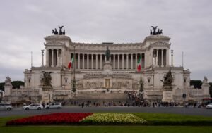
Vittoriano (Altar of the Fatherland) – Virtual Tour 360°
Start under the white marble of the Vittoriano, the monument Italy built for its own unification.
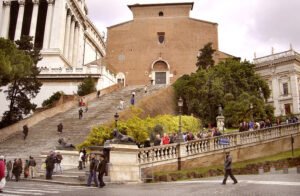
Basilica of Santa Maria in Ara Coeli – Virtual Tour 360°
Salita lungo l'Aracoeli, vista su Foro.
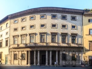
Palazzo Massimo alle Colonne – Virtual Tour 360°
Palazzo rinascimentale con curiosa pianta curva.
Download for tour navigation
🔒 The walk and the notes are open to everyone on this page. The files to take with you — the stop list as a PDF, and the GPX and KML tracks for your phone — come with a CHO account, and the free one includes them.
Walk it with the navigator on
It opens in the Google Maps app with every stop already loaded, in the order we put them in. From there the route is yours: pick how you travel — on foot, by bike, by public transport or by car — change where you start and where you end, drag the stops into a different order, and add places of your own along the way.