
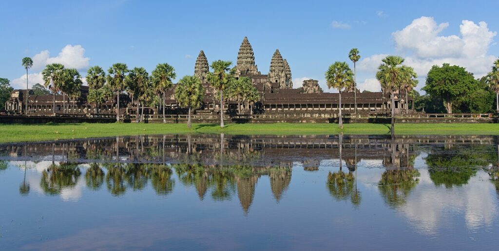
Angkor Archaeological Park, inscribed by UNESCO in 1992 (and simultaneously placed on the List of World Heritage in Danger due to looting and structural deterioration — removed from the Danger list in 2004 after successful conservation programmes), is a complex of temples, hydraulic infrastructure, and urban remains in the Siem Reap province of Cambodia covering approximately 400 km² — the heartland of the Khmer Empire (802–1431 CE), which at its peak in the 11th–13th centuries CE was the largest pre-industrial urban civilisation in the world, with the capital city of Angkor supporting an estimated 750,000–1,000,000 inhabitants within its broader urban area, an order of magnitude larger than any contemporary European city. The Angkor complex contains more than 1,000 individual temples and temple remains (the largest concentration of pre-industrial religious architecture in the world), of which Angkor Wat is the most significant: built by King Suryavarman II in approximately 1113–1150 CE as a state-temple mountain representing Mount Meru (the cosmic axis of the Hindu universe in the Vaishnava tradition, surrounded by the cosmic ocean represented by the 5.5 km-wide rectangular moat) in a plan of three concentric rectangular enclosures rising to the five towers of the central sanctuary, Angkor Wat is the largest religious monument on earth by total area (162 ha, including the moat and outer enclosure wall), with the world’s longest continuous bas-relief narrative frieze (approximately 800 m of carved stone panels in the third-level gallery, depicting scenes from the Hindu epics Ramayana and Mahabharata, the Churning of the Sea of Milk, and the Battle of Kurukshetra — approximately 1,800 m² of carved bas-relief in total). The Angkor Thom complex (the “Great City” — the late capital built by King Jayavarman VII approximately 1180–1219 CE, the most powerful Khmer ruler, after the Cham (from present-day Vietnam) sacked and briefly occupied the earlier Angkor capital in 1177 CE) with its Bayon temple’s 216 enormous carved faces, the Baphuon, and the Terrace of the Elephants constitutes the other major temple complex of the UNESCO site.
Angkor’s temple mountains and hydraulic civilisation — the Siem Reap UNESCO heritage landscape Angkor Wat · Angkor Thom · Bayon · Ta Prohm · Preah Khan · Tonle Sap Lake — 0 to 15 km
The Angkor Archaeological Park’s Outstanding Universal Value rests on two distinct systems that the UNESCO inscription recognises: (1) the temple architecture — the approximately 1,000 temple remains within the 400 km² protected zone, ranging from Angkor Wat and Angkor Thom (the largest and most elaborate) through major temples like Ta Prohm (the “jungle temple” photographed through the famous strangler-fig trees that have grown through the temple walls — maintained in this “unreconstructed” state to illustrate the original state of rediscovery, since all other major temples have been stabilised and partially reconstructed), Preah Khan (a university temple established by Jayavarman VII), Banteay Srei (the “Citadel of Women”, approximately 25 km north of the main complex, the 10th-century pink sandstone temple renowned for the finest quality of decorative carving in Angkor — the sandstone is fine-grained enough to hold detail comparable to stucco work), and the Roluos Group (the earliest 9th-century Khmer temples south of the main complex, predating the Angkor Wat and Angkor Thom periods and showing the evolution of the Khmer temple-mountain type from its earliest examples at Preah Ko and Bakong); and (2) the Angkor hydraulic system — the network of reservoirs (“baray”), canals, and water distribution infrastructure that supported the agricultural and domestic water supply of the Angkor urban population: the West Baray (8 km × 2.2 km, the largest ancient reservoir in the world still functional, capable of holding approximately 70 million cubic metres of water, built in the 11th century CE and maintained to the present) and the East Baray (approximately 7 km × 1.8 km, now dry but visible from satellite imagery) are the two primary reservoirs, fed by the Siem Reap river and supplemented by a network of channels that distributed water to the rice paddies of the Angkor urban hinterland. The hydraulic system is now understood by archaeologists (particularly through LIDAR surveys of the Angkor region conducted from 2012 onward, which revealed the full extent of the previously unknown sub-urban fabric of the Angkor urban area) to have supported the largest pre-industrial urban area ever identified by remote sensing — the LIDAR surveys identified low-density residential suburbs extending up to 35 km from the Angkor Wat centre, connected by the canal network, with a total settled area exceeding 1,000 km², making Angkor the largest urban complex (by geographic extent) of the pre-industrial world.
Tonle Sap Lake (the “Great Lake” of Cambodia, approximately 15 km south of Siem Reap — the largest freshwater lake in Southeast Asia, which expands seasonally from approximately 2,500 km² in the dry season to approximately 16,000 km² in the monsoon, due to the reversal of the Tonle Sap river’s flow when the Mekong flood pulse is large enough to push water upstream — one of the most remarkable hydrological phenomena in the world, and the source of approximately 70% of the freshwater fish consumed in Cambodia) was the ecological basis of Angkor’s food security and the reason the Khmer Empire chose this location for its capital. The floating villages on the Tonle Sap (the fishing communities of Kompong Phluk and Kompong Khleang, which move their houses onto floating pontoons as the lake expands and contracts — creating communities that live permanently on the water surface) are a living heritage of the water-based livelihood that has sustained the Angkor region for 1,200 years.
Practical information
Angkor Archaeological Park is accessed from Siem Reap city (approximately 5.5 km from Angkor Wat main entrance). Siem Reap has an international airport (Siem Reap Angkor International Airport, SAI, opened 2023, replacing the older airport — approximately 48 km from the city, with direct international connections to Bangkok, Kuala Lumpur, Singapore, Ho Chi Minh City, and Phnom Penh). Alternative: fly into Phnom Penh (PNH), then bus or boat to Siem Reap (approximately 6 hours by road or 5 hours by Tonle Sap ferry). Temple passes: 1-day ($37), 3-day ($62), or 7-day ($72) from the Angkor Enterprise ticket counter (required for entry; available at the main gate). Angkor Wat is open daily 05:00–18:00 (the sunrise over Angkor Wat reflected in the moat is one of the most photographed scenes in Asia — arrive by 05:30). Temple complex: tuk-tuk hired by the day ($15–20) is the standard way to cover the “small circuit” (Angkor Wat, Angkor Thom, Bayon, Ta Prohm, 4–5 hours) or the “grand circuit” (adds Preah Khan, Neak Pean, 6–8 hours). Electric vehicles and bicycles are available for hire in Siem Reap for the smaller circuit. Banteay Srei (the finest carved temple, 25 km north) requires a half-day trip. Best visiting months: November–February (dry season, temperatures 25–30°C, clear skies; December–January peak tourist season — book accommodation months in advance). March–May is extremely hot (35–38°C) but less crowded. June–October (monsoon — the temple grounds have standing water, the surrounding rice fields are green and spectacular, but some secondary roads and smaller temples are inaccessible).
Frequently Asked Questions
How was Angkor Wat constructed and what does its architectural design represent?
Angkor Wat was built by King Suryavarman II of the Khmer Empire (ruled approximately 1113–1150 CE — the most significant Khmer ruler of the early classical period, who extended the empire to its greatest geographic extent, incorporating present-day Thailand, Laos, and Vietnam in tribute relationships with the Angkor court) as a state temple and royal mausoleum in the Vaishnava tradition (dedicated to Vishnu — unusual in Angkor, where most major temple mountains were dedicated to Shiva and the lingam), representing in architectural form the cosmological geography of the Hindu universe as described in the Puranic literature: the five towers represent the five peaks of Mount Meru (the cosmic mountain at the centre of the universe in Hindu cosmology), the concentric rectangular moat represents the cosmic ocean that surrounds Mount Meru, and the three nested rectangular enclosures represent the three ranges of mountains that surround Mount Meru in the Puranic geography. The specific dimensions of Angkor Wat encode astronomical alignments: the temple is oriented exactly west (unique among Angkor temples, which are normally east-facing — the western orientation is associated with Vishnu and with the setting sun, suggesting the mausoleum function), and the sunset at the spring equinox (March 21) aligns exactly with the central tower as observed from the western entrance causeway, creating a specific astronomical calendar function for the temple’s orientation. The construction technology of Angkor Wat — the transport and placement of approximately 5–10 million tonnes of sandstone from the Kulen Hills quarry approximately 25 km north of the site — was the primary logistical achievement of Suryavarman II’s kingdom: the sandstone blocks (typically 1–1.5 m × 0.5 m × 0.5 m, weighing approximately 1.5–2 tonnes each) were transported by boat down the Kulen Hills river tributaries to the Siem Reap river and through the Angkor canal system to the temple site (dry-season river transport supplemented by elephant and human portage over land sections). The construction workforce was drawn from the corvée labour obligations of the Khmer population — the Khmer tax system was based on labour rather than material taxes, with each household obligated to provide a specific number of person-days of labour per year to the king, and major temple construction projects drew these obligations to a single site over sustained periods. The workforce size has been estimated from the logistics of the construction (moving approximately 10 million tonnes of stone in approximately 37 years of active construction) at approximately 50,000–100,000 workers in peak construction phases. The bas-relief programme (approximately 800 m of continuous narrative carved panels in the third gallery corridor, approximately 2 m high) represents a specific iconographic programme: the east gallery depicts the Churning of the Sea of Milk (the foundational Hindu creation narrative in which gods and demons churn the cosmic ocean to produce the amrita or divine elixir of immortality, using the serpent Vasuki as the churning rope and Mount Mandara as the churning stick — the 49 m-long east gallery panel is the most famous single bas-relief in Angkor, with approximately 88 asura demons and 92 deva gods on either side of the central image of Vishnu directing the churning); the south gallery depicts a military procession of Suryavarman II’s army with the 32 hells and 37 heavens of Hindu cosmology; the west gallery depicts the Battle of Lanka from the Ramayana; and the north gallery depicts the Battle of the Gods and the Asuras from the Mahabharata.
Why did the Khmer Empire decline and who discovered Angkor Wat for the Western world?
The decline of the Khmer Empire and the abandonment of Angkor as a capital city (approximately 1431 CE, when the Thai Ayutthaya kingdom sacked Angkor and the Khmer king relocated the capital to Phnom Penh on the Mekong river) is a complex historical event with multiple contributing causes, of which the most significant are now understood to be: (1) Climate change — the LIDAR survey data combined with historical climate proxies (speleothem records from caves in Southeast Asia) show that the period 1350–1450 CE in the Angkor region was characterised by a series of extreme climate events: prolonged droughts (potentially lasting 10–20 years) followed by extreme flood years — the “mega-drought” events that stressed the Angkor hydraulic system’s ability to maintain agricultural productivity, and the flood events that damaged the canal infrastructure more rapidly than it could be repaired; (2) the structural vulnerability of the hydraulic system — the LIDAR survey revealed that the Angkor water management network had become extremely complex by the late period, with hundreds of individual canal segments, dams, weirs, and overflow channels all requiring coordinated maintenance; any sustained disruption of the maintenance labour (from either demographic decline due to drought or political instability) would cause cascading failures in the network, reducing agricultural output and undermining the state’s ability to feed its population and pay its construction workforce; (3) the shift of regional trade to maritime routes — the growing importance of the sea-trade routes through the Strait of Malacca (driven by the expansion of Chinese maritime commerce in the Song and Yuan periods) was shifting the economic gravity of mainland Southeast Asia from the inland Angkor hydraulic empire (whose wealth was based on rice agriculture) to coastal polities better positioned to participate in the maritime trade. The “discovery” of Angkor Wat by Henri Mouhot (1826–1861 CE, a French naturalist who encountered the temple during a botanical expedition and wrote a widely read account published in 1863 CE, “Travels in the Central Parts of Indo-China, Cambodia, and Laos”) is one of the most misunderstood events in colonial-era cultural history: Angkor Wat was never “lost” — it was a functioning Buddhist monastery throughout the period of the “abandonment” of Angkor as a capital (Angkor Wat was reconverted to Theravada Buddhism in approximately the 14th century and has functioned as a Buddhist monastery continuously from approximately 1440 CE to the present — the Buddhist monks of Angkor Wat were the actual guides who led Mouhot to the temple in 1860 CE). Mouhot’s account was presented in the European press and public as the “discovery” of a lost civilisation, a framing that reflected the colonial-period assumption that “civilisation” in Southeast Asia could only have been produced by a lost Indian or Chinese civilisation rather than by the ancestors of the contemporary Khmer people — an assumption that the 20th-century Khmer archaeology has conclusively refuted by establishing the continuous Khmer cultural genealogy from the pre-Angkor period to the present.
EXCERPT: Angkor Archaeological Park, UNESCO-inscribed in 1992, encompasses the temples of the Khmer Empire (802–1431 CE) in Cambodia — Angkor Wat (the world’s largest religious monument at 162 ha, with 800 m of bas-relief), the Bayon’s 216 stone faces, Ta Prohm’s strangler-fig-covered galleries, and the hydraulic system that supported a 750,000-person capital city on the Tonle Sap.
META: UNESCO World Heritage Sites near Angkor Archaeological Park Cambodia: Preah Vihear Temple 240 km north (UNESCO 2008), Sambor Prei Kuk 100 km south (UNESCO 2017) — Angkor Wat Siem Reap UNESCO heritage, Khmer Empire temple mountain hydraulic civilisation, LIDAR survey largest pre-industrial city, Bayon Jayavarman VII, Ta Prohm jungle temple Cambodia.
Sources
- S1 — UNESCO World Heritage Centre — Angkor (Ref. 668) — https://web.archive.org/web/20230601000000/https://whc.unesco.org/en/list/668/
- S2 — UNESCO World Heritage Centre — Statement of Outstanding Universal Value (Ref. 668) — https://whc.unesco.org/en/list/668/
Spotted an error? Write to the editors and we correct it the same day.