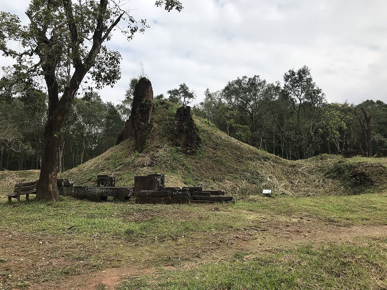
Mỹ Sơn Sanctuary — inscribed by UNESCO in 1999 — preserves the most significant Hindu religious complex built by the Cham civilisation: a valley site enclosed by jungle-covered mountains in Quảng Nam Province, central Vietnam, containing the ruins of approximately 70 brick temple towers (kalan) and ceremonial buildings constructed by the kings of Champa between the 4th and 13th centuries CE as the spiritual capital of the Cham Kingdom (Nagara Champa) — the most important royal temple complex of Indochina after Angkor Wat, dedicated primarily to the Shaiva form of Hinduism (the worship of Shiva in his role as supreme deity), with the main tower at each group (called a kalan) serving as a symbolic representation of Mount Meru (the cosmic mountain at the centre of the Hindu universe) and the residences of the god Shiva on Earth.
The Cham Hindu temples, the Champa Kingdom, and Mỹ Sơn in the jungle valley Group B/C/D (the largest surviving cluster, with the best-preserved decorative programmes — B1 is the main kalan, C1 is the mandapa/hall, D1 and D2 are galleries now housing the Mỹ Sơn museum exhibits) · Group A (the original royal sanctuary, almost entirely destroyed by US bombing in 1969 CE — only Group A1’s foundations remain) · Group G (late-period Cham towers, 10th–11th century CE, with well-preserved decorative panels) · Group E/F (among the earliest surviving towers, 8th–9th century CE) — Duy Phú Commune, Duy Xuyên District, Quảng Nam Province, central Vietnam
The Cham civilisation (the Indianised maritime kingdom that controlled the central coastal region of what is now Vietnam from approximately the 2nd century CE until the final destruction of Cham political independence by the Vietnamese Nguyễn lords in the 17th century CE) was one of the major cultural and political powers of ancient Southeast Asia: a maritime empire whose economy was based on control of the sea trade routes through the South China Sea and on the agricultural production of the coastal river valleys, whose culture was thoroughly Indianised (adopting Hinduism and later Buddhism, the Sanskrit language and script, Indian architectural and sculptural traditions, and Indian conceptions of divine kingship), and whose art and architecture represent one of the most distinctive and accomplished regional variants of the Hindu-Buddhist artistic tradition of South and Southeast Asia. The choice of the Mỹ Sơn valley as a royal sanctuary site: the valley is approximately 40 km southwest of the modern city of Da Nang, enclosed on all sides by jungle-covered limestone mountains that create a natural amphitheatre, with a small stream (the Khe Thuyền) running through the centre — a topographic setting that the Cham kings (following the Indian tradition of selecting sacred sites that embody cosmological principles) identified as the earthly equivalent of Mount Meru’s valley. The founding king: the earliest Cham inscriptions at Mỹ Sơn identify the sanctuary’s founding with King Bhadravarman I (r. approximately 349–361 CE or late 4th century CE), who built the first wooden sanctuary dedicated to Shiva at the site; subsequent Cham kings rebuilt, expanded, and elaborated the sanctuary over nine centuries, with the current brick towers dating primarily from the 7th–13th centuries CE. The brick tower construction (a Cham architectural speciality that is not fully understood by modern archaeologists): the Cham towers are constructed from fired red brick using a technique that produces wall faces of extraordinary smoothness and precision — individual bricks fit together so closely that the mortar joints are almost invisible, and the carved decorative elements (pilasters, kala (monster-face) door frames, narrative relief panels showing Shiva and the Hindu epics) are executed directly in the brick surface rather than applied as separate stone panels. The nature of the binding agent between the bricks is debated: early 20th-century French scholars proposed that the Cham builders used a resin (possibly from the dammar tree) rather than lime mortar; recent analysis has suggested that the bricks were laid wet (using the clay of the bricks themselves as a bonding agent, then the whole structure fired in situ) — the exact technique remains an open question that modern restoration teams have found extremely difficult to replicate. The Vietnam War destruction: Mỹ Sơn was used as a headquarters and supply depot by the Viet Cong during the Vietnam War (the site’s remote jungle location and the extensive earthworks and tunnel systems in the valley made it a natural base). On 10–11 August 1969 CE, US special forces (sources say a B52 strike) bombed the valley, destroying Group A (the oldest and most architecturally significant group — the main kalan A1, which French colonial archaeologist Henri Parmentier had described in 1904 CE as the finest Cham building, was almost entirely demolished), several buildings in Groups B and C, and causing structural damage throughout the site. Approximately 25 of the surviving towers were seriously damaged, and the total destruction of Group A1 (which had been rebuilt 7 times by Cham kings over the centuries and was the symbolic heart of the sanctuary) remains one of the major heritage losses of the Vietnam War. Post-war restoration: beginning in the 1980s CE with Polish and Vietnamese conservation teams, and significantly expanded after the 1999 UNESCO inscription with international funding from UNESCO, Germany, India, Japan, and other sources. The restoration programme has focused on structural stabilisation and waterproofing rather than full reconstruction — the towers that survived are being maintained and protected from further deterioration, but the destroyed Group A buildings are not being rebuilt. As of the early 2020s, approximately 20 towers are open to visitors in relatively good condition; the ruins of Group A are accessible as an archaeological landscape.
Practical information
Mỹ Sơn Sanctuary is located approximately 40 km southwest of Da Nang and 60 km west of Hội An by road (approximately 1.5 hours from Hội An). The site is accessible by road only — no public transport serves the site directly; the standard approach is by guided tour from Da Nang or Hội An (most hotels and travel agencies in both cities offer half-day and full-day tours to Mỹ Sơn, often combined with Hội An or the Cham Museum). The site’s visitor infrastructure includes a ticketed entrance (approximately $10 USD in 2024), a small museum in the converted Group D buildings displaying Cham sculpture and explanatory panels, and shuttle carts from the main entrance to the tower groups (a 2-km road through the jungle). The primary visitor circuit: Group B/C/D (the largest surviving cluster with the best-preserved carved panels and doorframes, approximately 45–60 minutes), Group G (10th–11th century towers with well-preserved decorated pilasters, approximately 20 minutes), and Group E/F (the earliest surviving towers, partially reconstructed, approximately 15 minutes). Allow 2–3 hours for a full visit. The site is most atmospheric in early morning before tour groups arrive; the jungle humidity and the sound of the Khe Thuyền stream running through the valley create a deeply evocative setting even in the partial ruins of the post-war complex. Best season: February–July (dry season in Quảng Nam — the valley floods severely in the October–December wet season and can be inaccessible).
Frequently Asked Questions
Who were the Cham people and what happened to the Champa Kingdom?
The Cham people (speakers of Cham, an Austronesian language — a language family that includes Malay, Javanese, Tagalog, Malagasy, and the Polynesian languages, making the Cham one of the very few Austronesian-speaking populations in mainland Southeast Asia) are the descendants of the population that created the Champa Kingdom and inhabited the central coastal region of present-day Vietnam from approximately the 2nd century CE until the 17th century CE, when the last Cham political entities (the small kingdoms of Panduranga and Kauthara in what is now Khánh Hòa and Bình Thuận provinces) lost their independence to the expanding Vietnamese Nguyễn lords. The Cham population today is approximately 160,000–170,000 people, living primarily in the south-central Vietnamese provinces of Ninh Thuận and Bình Thuận, with smaller communities in Cambodia (where they were subjected to particular brutality by the Khmer Rouge — the Cham minority was targeted for near-genocide by Pol Pot’s regime, with approximately 200,000 Cham killed in 1975–1979 CE) and in Vietnam’s Central Highlands. The Cham are divided into two religious communities: the western Cham (in Cambodia and some Vietnamese communities) who are Muslim, having converted from Hinduism and Buddhism during the 14th–15th centuries CE through contact with Islamic traders from the Malay world; and the eastern Cham (in the Ninh Thuận/Bình Thuận area) who maintain a unique syncretic religion combining pre-Islamic Cham Hindu and Buddhist traditions with some Islamic and animist elements, called Bani (a local word derived from the Arabic “bani” meaning “sons of” — the sons of the ancient tradition). The political history of the Champa Kingdom: Champa was never a politically unified empire in the way that, for example, the Khmer Empire of Cambodia or the Vietnamese Đại Việt state were — it was rather a series of regional polities sharing a common culture, religion, and language, occasionally unified under powerful kings but more often organised as four or five semi-autonomous regions (the Sanskrit geographical terms Amaravati, Vijaya, Kauthara, Panduranga — corresponding roughly to the modern Vietnamese provinces of Quảng Nam, Bình Định, Khánh Hòa, and Ninh Thuận respectively). The decline of Champa was primarily the result of the southward expansion of the Vietnamese state (Đại Việt, based in the Red River Delta) — a process that began with the Vietnamese conquest of the Cham capital at Indrapura (near modern Đà Nẵng) in 1306 CE and continued with further losses (the fall of the great Cham capital at Vijaya/Đồ Bàn in 1471 CE, the end of the Cham–Vietnamese conflict). By the 17th century CE, the remaining Cham kingdoms occupied only a small strip of the southern Vietnamese coast, and by the end of the 17th century CE they had been fully absorbed into the Vietnamese political system.
What is the mystery of Cham brick construction technique?
The construction technique used by Cham builders to create the smooth, precisely fitted brick walls of Mỹ Sơn and the other Cham temple towers (there are approximately 20 Cham tower sites along the Vietnamese coast, the most important others being at Tháp Đôi in Qui Nhơn, Po Nagar near Nha Trang, and Tháp Bà near Phan Rang) is one of the most discussed and least resolved technical questions in Southeast Asian architectural history. The visible facts: the Cham brick walls are laid with joints so fine that they are almost invisible to the naked eye — the bricks fit together with a precision comparable to the finest dressed stone masonry, and the decorated surfaces (carved pilasters, kala doorframe heads, narrative relief panels) are executed directly in the brick face with the same precision and sharpness of line as stone carving. The binding agent question: French colonial archaeologists working at Mỹ Sơn in the early 20th century CE (Henri Parmentier and his colleagues) noted the absence of visible lime mortar in the joints and proposed that the Cham builders used an organic resin (possibly derived from dammar, a tropical tree resin used in traditional Southeast Asian lacquerwork and as a binding agent in various craft applications) as the mortar between bricks. This “resin mortar” theory was widely accepted for decades and influenced restoration approaches — early Vietnamese restoration attempts in the 1980s CE that used lime mortar to rebind fallen Cham bricks failed, with the repaired areas showing visually distinct modern mortar joints and different weathering behaviour from the original. Later analysis (microscopic examination of original joint material by Vietnamese and international conservation scientists in the 1990s–2000s CE) found evidence of plant material (possibly rice husks, resinous materials, and other organic compounds) in the original joints, but the precise identification of the binding agent and the construction sequence remains uncertain. An alternative theory (supported by experimental archaeology work by Indian conservation teams, drawing on parallels with related brick temple construction in South India, where the Cham brick tradition ultimately derived) proposes that the bricks were laid using the clay of the bricks themselves as a bonding agent while both the bricks and the mortar joint were still plastic (wet), then the whole structure was fired in situ using large-scale kilning. This “fired in situ” hypothesis explains the extremely fine joints (clay-on-clay wet bonding before firing creates minimal gap) and the carving quality (the carved decoration could have been applied while the brick was still plastic or immediately after firing when the surface was relatively workable). As of the 2020s CE, restoration teams at Mỹ Sơn are using a range of approaches: for structural repairs, combinations of traditional lime-based mortars with organic additives; for decorative panel conservation, consolidation with compatible polymer resins. None of the repair mortars has achieved the visual or physical match of the original construction, and the mystery of Cham brick technique remains genuinely unsolved.
How was Mỹ Sơn damaged during the Vietnam War and what was lost?
Mỹ Sơn Sanctuary suffered severe and irreversible damage during the Vietnam War — damage that constitutes one of the major heritage losses of the 20th century and that fundamentally changed the character of the site from a largely intact ancient sanctuary to a collection of ruins. The military context: the Mỹ Sơn valley’s remote location (approximately 40 km from Da Nang, at the end of a narrow valley road through the jungle) and its extensive pre-existing earthworks and tunnel systems made it a natural Viet Cong (National Liberation Front) base during the Vietnam War, used as a command post and supply depot for operations in the surrounding region. The US military’s response: on 10–11 August 1969 CE, US forces (the precise strike type — B-52 carpet bombing or tactical air strikes — is disputed in different historical accounts) conducted a bombing operation against the valley, targeting the known VC presence in the site. The damage: the bombing destroyed Group A (the oldest and most architecturally and symbolically significant group of the Mỹ Sơn sanctuary) almost entirely. Group A included the main kalan A1 — a tower that the French archaeologist Henri Parmentier (who conducted the first systematic survey of Mỹ Sơn in 1898 CE and subsequent excavations in 1901–1904 CE and 1927 CE) had described as “the most beautiful, the best-preserved, and the most artistically significant” Cham structure in existence. The kalan A1 had been rebuilt seven times by successive Cham kings over its history (inscriptions at the site record rebuilding by King Vikrantavarman II in the late 9th century CE and by King Harivarman IV in the early 12th century CE, among others), and its final pre-war form represented a thousand years of continuous religious use and artistic elaboration. In addition to the virtually complete destruction of Group A, the bombing seriously damaged several buildings in Groups B, C, and G, and caused lesser structural damage throughout the site. The assessment by conservation professionals: the destruction of Group A1 is irreversible — the sculptural programme, the architectural details, and the spatial organisation of the most important building in the sanctuary are known only through Parmentier’s 1904 CE photographs and drawings, and cannot be reconstructed. The 1999 UNESCO World Heritage inscription specifically acknowledged both the outstanding universal value of the surviving structures and the irreversible nature of the war damage, noting that Mỹ Sơn is “an outstanding example of an architectural ensemble which illustrates a significant stage in history” despite its damaged condition.
EXCERPT: Mỹ Sơn Sanctuary Vietnam (UNESCO 1999) — the spiritual capital of the Champa Kingdom: 70 red-brick Hindu temple towers built from the 4th to 13th centuries CE by Cham kings in a jungle valley of Quảng Nam Province, dedicated to Shiva — the finest surviving Cham architecture, severely damaged by US bombing in August 1969 CE.
META: UNESCO World Heritage Sites near Mỹ Sơn Sanctuary Vietnam: Hội An Ancient Town 40 km northeast, Complex of Hué Monuments 130 km north — central Vietnam’s Cham and Vietnamese imperial heritage circuit from the Hindu towers of Mỹ Sơn to the medieval merchant port of Hội An to the Nguyễn Imperial City at Hué.
Sources
- S1 — UNESCO World Heritage Centre — My Son Sanctuary (Ref. 949) — https://web.archive.org/web/20230601000000/https://whc.unesco.org/en/list/949/
- S2 — UNESCO World Heritage Centre — Statement of Outstanding Universal Value (Ref. 949) — https://whc.unesco.org/en/list/949/
Spotted an error? Write to editorial@culturalheritageonline.com and we correct it the same day.