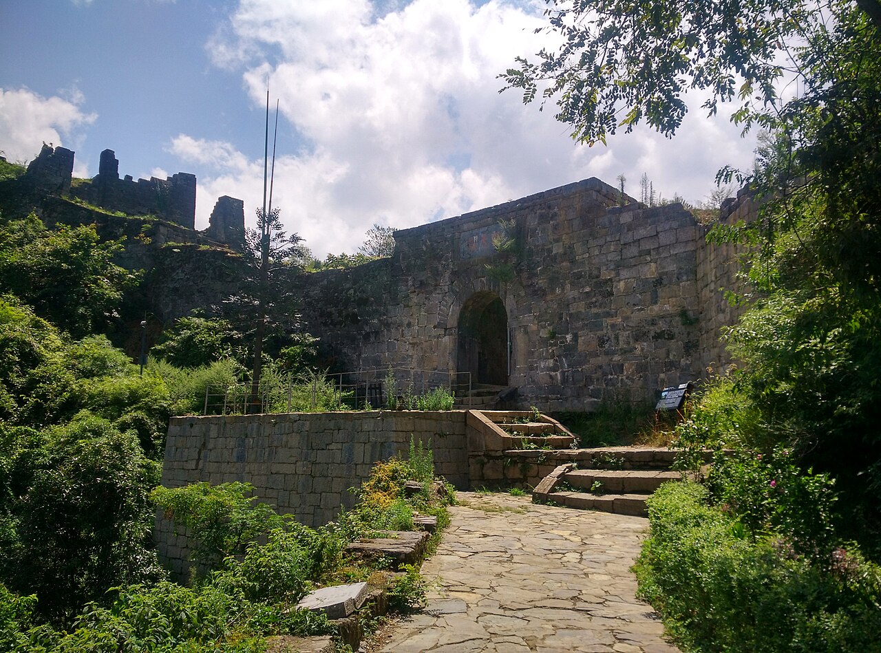
The Tusi Sites, inscribed by UNESCO in 2015 as a serial inscription comprising three component sites in southern China — Hailongtun Tusi Fortress (Zunyi, Guizhou), Laosicheng Tusi City (Yongshun, Hunan), and Tangya Tusi Site (Xianfeng, Hubei) — represent the material culture of the Tusi chieftain system (土司制度, Tǔsī Zhìdù), the indigenous governance institution by which the Chinese imperial state administered ethnic minority populations in its southwestern frontier from the Tang dynasty (618–907 CE) through the Qing dynasty (1644–1912 CE), when the policy of “converting chieftains to native officials” (改土归流, gǎitǔguīliú) progressively replaced the hereditary chieftain system with direct imperial administration. The inscription’s Outstanding Universal Value rests on the three components’ collective documentation of the tusi system’s full institutional and spatial expression: Hailongtun (海龙屯, the “Sea Dragon Fortress”, built 1257 CE and expanded 1601 CE, a mountain citadel at the summit of Longyan Mountain above the Loushui River in Zunyi, Guizhou, documenting the military architecture of the tusi chieftain’s defensive capacity); Laosicheng (老司城, “Old Division City”, the planned capital city of the Tusi Chieftain of Yongshun, operational from 1135 CE to 1728 CE, the largest and most complete surviving tusi city plan in China); and Tangya (唐崖, the tusi chieftain seat of the Xianfeng native chieftaincy in western Hubei, documenting the ceremonial and residential architecture of the tusi governing complex). Together, the three sites document the tusi system’s transformation of indigenous ethnic minority society in southern China from autonomous tribal confederacies to governed chieftaincies that mediated between the Chinese imperial centre and the ethnic populations of Guizhou, Hunan, and Hubei — the institutional predecessor to the modern Chinese system of ethnic autonomous regions.
Hailongtun and the Guizhou heritage circuit: from tusi fortresses to karst landscapes Wulingyuan Zhangjiajie Hunan · Chongqing Dazu Rock Carvings · South China Karst Libo — 200 to 400 km
Two Hundred Kilometres north of Hailongtun Tusi Fortress by road (approximately 3 hours from Zunyi to Chongqing by expressway via the G75 or G76), Chongqing City is the nearest major transport hub for visitors to the Guizhou component of the Tusi Sites. Chongqing’s own UNESCO inscription — the Dazu Rock Carvings (大足石刻, inscribed 1999), located 90 km west of Chongqing at Dazu County — is the most significant Buddhist rock-carving complex in southern China and represents the contemporaneous Buddhist cultural production of the Song-dynasty Sichuan basin that overlapped geographically with the early tusi chieftain system’s establishment in Guizhou (the earliest tusi appointments in Guizhou date to the Song dynasty, 960–1279 CE, approximately the period when the Dazu carvings’ most significant cliff-sculptures were commissioned). The Baodingshan (Precious Summit Hill) complex at Dazu — comprising the Great Buddha Bay (a continuous 30-metre-high carved cliff face of 31 principal sculpture groups in a horseshoe-shaped valley, approximately 500 metres of continuous relief carving) and the Small Buddha Bay — is the most architecturally innovative Buddhist rock-carving complex in China: the sculptures are arranged as a continuous narrative sequence (rather than the individual cave-unit organisation typical of the northern rock-carving tradition at Yungang and Longmen), designed to be walked in a single processional circuit rather than visited as discrete units. From Zunyi (the Guizhou component site for Hailongtun), Chongqing is reached by the Chengdu-Guiyang HSR (approximately 1.5 hours from Zunyi Station to Chongqing North) or by the Chengdu-Guiyang HSR to Chongqing West.
Two Hundred Kilometres east of the Hailongtun Tusi Fortress and approximately 150 km southeast of the Laosicheng Tusi City by road and HSR (from Laosicheng near Yongshun County town, approximately 3.5 hours by coach to Zhangjiajie City, and approximately 2 hours from Zunyi to Zhangjiajie by car via G75 and Hunan expressways), the Wulingyuan Scenic Area (武陵源风景名胜区, inscribed UNESCO 1992) is the most spectacular of the Tusi Sites’ proximity heritage companions: a landscape of more than 3,000 quartzite sandstone pillar formations (the “Avatar Mountains” of the 2009 James Cameron film that appropriated their visual identity) rising from the Suoxiyu (锁溪峪) valley floor of the Zhangjiajie Forest Park in northwestern Hunan. The geological formation that produced the Wulingyuan pillars (Devonian-period quartzite sandstone, approximately 380 million years ago, differentially eroded by vertical jointing and stream action over tens of millions of years to produce isolated pillar formations up to 400 metres tall) is unrelated to the Tusi cultural landscape but geographically adjacent: the Wuling Mountain range (Wulingyuan) that forms the physical context for the Wulingyuan pillars is the same mountain system whose complex topography of deep gorges and isolated valleys provided the defensive terrain that made the tusi chieftain system necessary in the first place. The inaccessibility of the Wuling Mountain terrain — the reason that Chinese imperial administration could not practically extend direct governance to the ethnic minority populations of the Tujia (土家族), Miao (苗族), and other groups living in the gorges — was exactly the geographic condition that required the tusi intermediary system. From Zhangjiajie Airport (ZJJ), Wulingyuan is accessible in approximately 45 minutes by tourist bus; from the HSR junction at Zhangjiajie West, approximately 40 minutes. The Zhangjiajie-Huaihua HSR (opened 2021) connects Zhangjiajie to the national HSR network in approximately 2 hours to Zhangjiajie then transfer.
The Laosicheng Tusi City component (老司城, in Yongshun County, Xiangxi Tujia and Miao Autonomous Prefecture, Hunan Province) is the largest of the three serial inscription components and represents a planned administrative city rather than a military fortress. Operational from approximately 1135 CE (the earliest identified construction evidence) to 1728 CE (when the Qing emperor Yongzheng’s gǎitǔguīliú policy abolished the Tusi of Yongshun’s authority and replaced the tusi governance with direct Qing administration), Laosicheng accommodated a population of approximately 6,000 at its peak (16th–17th centuries CE) within a planned urban layout comprising: the palace district (the tusi chieftain’s residential and administrative compound, with the Silk Street ritual axis), the military district (barracks, weapon stores, training grounds), the market district (commercial zone outside the inner walls), and the religious district (the ancestral temple, the Confucian school, and multiple Tujia folk religion shrines). The archaeological excavation of Laosicheng (ongoing since 2013) has identified the complete urban plan through a combination of surface survey and ground-penetrating radar prospection, recovering architectural foundations, ceramic assemblages, bronze seals of the tusi administration, and documentary evidence of the tusi system’s governance records (including land registers, tribute records, and diplomatic correspondence with the Ming imperial court). From the nearest HSR station (Jishou Station on the Shanghai-Kunming HSR, approximately 2 hours north of Laosicheng by road via Guzhang County), Laosicheng is accessible by coach or hired car.
Practical information
The Tusi Sites serial inscription comprises three component sites spread across three Chinese provinces: Hailongtun (Zunyi, Guizhou, most accessible — 1.5 hours from Zunyi to the site by road), Laosicheng (Yongshun County, Hunan, approximately 2 hours from Jishou HSR Station by road), and Tangya (Xianfeng County, Hubei, most remote — approximately 4 hours from Wuhan or 5 hours from Chongqing by road). Most international visitors focus on one or two of the three components. Hailongtun (the military fortress component) is the most visually dramatic and the most accessible, with a well-developed visitor infrastructure including a cableway to the fortress entrance and an on-site museum (opened 2015) documenting the tusi system through archaeological finds. Laosicheng (the planned city component) requires more context and imagination as the urban fabric is largely subsurface, though the Laosicheng Heritage Museum in Yongshun County town provides an interpretive introduction. Tangya (the Hubei administrative seat component) is the least visited of the three sites but is the most complete in terms of surviving surface architecture. The Guizhou circuit (Hailongtun → Guiyang → South China Karst Libo → Zunyi) is the most practical for international visitors, with Guiyang Airport (KWE) providing the best air connections. Zunyi itself is historically significant as the site of the Zunyi Conference (January 1935), at which Mao Zedong consolidated his leadership of the Chinese Communist Party during the Long March — the Zunyi Conference Site is a pilgrimage destination for Chinese domestic tourists and the city’s primary historical attraction alongside Hailongtun.
Frequently Asked Questions
What was the tusi system and why did China develop it to govern its southwestern frontier?
The tusi system (土司制度, Tǔsī Zhìdù, literally “Earth Lord System” or “Native Official System”) was an imperial Chinese governance institution that administered ethnic minority populations in the southwestern frontier provinces (Guizhou, Yunnan, Hunan, Hubei, Sichuan, Guangxi, Guangdong) from approximately the Tang dynasty (618–907 CE) through the early Qing dynasty (17th–18th centuries CE) by appointing hereditary indigenous leaders (tusi, 土司, “native officials”) as agents of the imperial state rather than replacing them with centrally appointed officials. The system emerged from the practical impossibility of extending direct imperial administrative control to the mountainous frontier zones inhabited by non-Han ethnic groups (the Tujia, Miao, Yi, Bai, Zhuang, and others) who spoke non-Chinese languages, practiced non-Confucian customary law, and occupied terrain (deep gorges, isolated mountain valleys) that made military pacification and economic extraction practically difficult. The tusi solution was to grant the existing indigenous leaders formal imperial appointments (official ranks within the Chinese bureaucratic hierarchy), hereditary succession rights (subject to imperial confirmation), and the authority to collect local tribute and mobilise local military forces — in exchange for tribute payments, military loyalty, and the symbolic performance of imperial ritual submission (periodic court visits, the use of Chinese imperial titles and seals, and the education of tusi heirs in Chinese script and Confucian texts). The system worked as long as the tusi’s local authority was unchallenged and the central government’s priority was stability rather than administrative integration. It began breaking down in the 16th century CE as the Ming imperial government’s revenue crisis drove more aggressive attempts to extract tribute from tusi territories, provoking military resistance (the most significant was the Yang Yinglong Rebellion of 1587–1600 CE, in which the Hailongtun tusi Yang Yinglong led a 13-year military campaign against Ming authority that required a 200,000-man military expedition to suppress — the destruction of the Hailongtun fortress in the 1600 CE campaign is the archaeological horizon visible at the site today). The Qing dynasty’s gǎitǔguīliú policy (1726–1750 CE under the Yongzheng Emperor) systematically abolished the tusi system and replaced the hereditary chieftains with centrally appointed officials, but the ethnic minority communities’ customary law, land tenure patterns, and cultural practices survived the administrative transition and are the basis for the contemporary Chinese ethnic minority autonomous region system.
What does the Hailongtun archaeological excavation reveal about the tusi system at its military peak?
The Hailongtun fortress was built in 1257 CE by the Yang tusi chieftain of Bozhou (播州, the tusi territory encompassing modern northern Guizhou and southern Chongqing) as a defensive refuge against the Mongol invasion of the Song dynasty’s southern frontier, and was dramatically expanded by Yang Yinglong (the 29th-generation Yang tusi chieftain) between 1587 and 1600 CE in preparation for his military resistance to Ming authority. The 2012–2015 archaeological excavation of the fortress — the most extensive archaeological project at a tusi site to date — has revealed a military complex of approximately 1.2 km² on the summit of Longyan Mountain (elevation approximately 1,200 metres), with nine successive defensive gate systems on the access path (each gate requiring a separate assault by attackers, which is why the 1600 CE Ming military expedition took 114 days to capture the fortress despite vastly superior numbers), a palace compound within the inner fortress (the tusi chieftain’s residential and ceremonial space, with a throne room, banqueting halls, and residential apartments excavated to foundation level), military barracks, water storage cisterns (providing independence from external water supply during siege), and storage magazines for food and weapons. The fortress’s most significant architectural feature is the nine-gate sequence along the fortified access path: each gate (Chaotian Gate, Feihong Bridge Gate, Aspen Gate, Feilong Bridge Gate, etc.) represents a separately defensible bottleneck in the approach path, requiring attackers to fight through each position in sequence. The ceramic assemblages recovered from the palace compound include both locally produced Guizhou stoneware and high-quality imported porcelain from the Jingdezhen kilns (Jiangxi Province), demonstrating that the Bozhou tusi court maintained access to prestige goods from the Chinese market economy even while militarily resisting imperial authority. The 1600 CE destruction event is archaeologically visible as a dense burnt-earth horizon across the entire palace complex, with fired architectural timbers and roof tile fragments collapsed in situ — a well-dated archaeological destruction event that allows precise dating of the architectural phases above and below the horizon.
How do the three Tusi Sites compare architecturally and what does each reveal about the tusi system?
The three Tusi Sites components represent different functional aspects of the tusi governance system and use different architectural typologies to express them: Hailongtun expresses military power (mountain fortress, multiple defensive gate systems, barracks infrastructure, strategic elevation commanding the Loushui River crossing); Laosicheng expresses administrative and civic power (planned city, royal street axis, palace district, market district, religious infrastructure, civilian residential zones); and Tangya expresses ceremonial and symbolic power (the ancestral hall at the ceremonial centre of the tusi residential compound, with the “Wu Xing Chao Gong” archway — the “Five Ministers Paying Court” stone ceremonial arch — that is the best-preserved example of tusi ceremonial gateway architecture in China). The three typologies — military fortress, planned city, and ceremonial compound — collectively document the tusi chieftain’s three roles in the imperial system: military ally (the tusi mobilised local forces for the Ming emperor in southern border campaigns, for which Yang Yinglong of Bozhou supplied troops for the Imjin War against Japan’s invasion of Korea in 1592–1598 CE, a fact that makes the subsequent Yang Yinglong Rebellion particularly significant as a defection by a militarily capable ally); administrative agent (the tusi collected local tribute, registered population, allocated land, and maintained local order on behalf of the Ming state); and symbolic subordinate (the tusi performed imperial rituals, used imperial titles and seals, and sent heirs for education in Beijing to demonstrate their cultural assimilation into the Confucian imperial order). The three sites thus provide a three-dimensional portrait of the tusi institution that no single site could offer alone — which is precisely why the UNESCO serial inscription format was chosen: to document a systemic governance institution rather than a single monument.
Sources
- S1 — UNESCO World Heritage Centre — Tusi Sites (Ref. 1474) — https://web.archive.org/web/20230601000000/https://whc.unesco.org/en/list/1474/
- S2 — UNESCO World Heritage Centre — Statement of Outstanding Universal Value (Ref. 1474) — https://whc.unesco.org/en/list/1474/
Spotted an error? Write to editorial@culturalheritageonline.com and we correct it the same day.