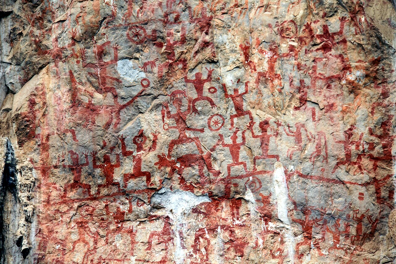
The Zuojiang Huashan Rock Art Cultural Landscape, inscribed by UNESCO in 2016, protects 38 rock art sites distributed along 105 kilometres of the Zuojiang (Left River) and Mingjiang River valleys in the Guangxi Zhuang Autonomous Region of southern China — the largest concentration of Bronze and Iron Age rock paintings in East Asia, created by the Luo Yue people (ancestors of the modern Zhuang ethnic group) from approximately the 5th century BCE to the 2nd century CE over a period of approximately 700 years. The paintings — executed in red ochre pigment (a mixture of iron oxide, animal blood or fat, and tree sap applied directly to the vertical or overhanging faces of limestone cliffs above the river level, many of them accessible only by boat and only at certain flood stages) — are dominated by a single compositional type: large central human figures (1–3 metres tall) depicted full-frontal with arms raised and knees bent in a posture interpreted variously as a sacred dance, a ritual salutation, a drumming stance, or a warrior preparation pose, surrounded by smaller subsidiary figures, bronze drums (represented in plan view as large circles with radiating elements), dogs, horses, birds, and boat-type symbols. The largest site — Huashan (画山, “Painting Mountain”), near Ningming County, approximately 52 km from the Vietnam border — contains 1,900 individual figures in 110 groups on a 250-metre-wide by 40-metre-high cliff face, making it the single largest rock art site in China by figure count and the defining image of the Zuojiang Huashan tradition.
The Zuojiang rock art landscape: from Guangxi to the Vietnam border and the Karst coast South China Karst Guilin · Detian-Ban Gioc Waterfall · Beihai Gulf of Tonkin — 120 to 350 km
One Hundred and Twenty Kilometres north of the Huashan rock art site by road (approximately 1.5 hours from Ningming County town to Nanning City via the G72 Expressway), Nanning (南宁, the capital of Guangxi Zhuang Autonomous Region) is the primary transport hub for visitors to the Zuojiang Huashan inscription. From Nanning, all 38 component sites are accessible by a combination of road (approximately 1–2 hours by expressway to Ningming or Chongzuo) and river cruise (the Zuojiang river cruise from Chongzuo County town or Ningming County town to Huashan Cliff, the primary tourist experience, runs approximately 2 hours one-way by tourist boat and provides the most evocative access — the cliff face paintings are only fully visible from the river, from which the scale of the paintings and their positioning (the largest figures are at heights of 40 metres above river level, visible only from the opposite bank or from the river) can be properly appreciated). The South China Karst’s Guilin-Yangshuo component (inscribed 2007 in the Phase 1 South China Karst inscription, 350 km north of Ningming by road) is the most famous visual landscape companion to the Zuojiang rock art — both landscapes are formed in the same Devonian-period limestone karst geology that produces the vertical cliff faces used by the Luo Yue painters (the Huashan cliff is a sheer limestone face formed by the Zuojiang River’s lateral erosion of the karst massif, exactly the same process that produces the Li River’s famous tower karst scenery near Guilin). From Nanning, Guilin is reached by the Guiyang-Guangzhou HSR (approximately 2.5 hours from Nanning to Guilin North). The most dramatic section of the Li River scenery (the Yangshuo Eleven Peaks stretch, approximately 85 km from Guilin City to Yangshuo Town by river cruise) is accessible by tourist cruise (daily departures from Guilin Zhujiang Wharf, approximately 4.5 hours) and is the most photographed landscape in Guangxi.
Two Hundred Kilometres southwest of the Huashan rock art site by road (approximately 2.5 hours from Ningming County town to the China-Vietnam border crossing at Detian, accessible via the G72 Expressway to Daxin County and then the county road to Detian), the Detian-Ban Gioc Waterfall (德天瀑布, on the Chinese side; Thác Bản Giốc, on the Vietnamese side) is the most spectacular natural heritage landscape in the Zuojiang proximity zone and one of the most unusual border landscapes in Asia: a four-tier cascading waterfall approximately 200 metres wide, spanning the China-Vietnam border on the Guichun River, so that tourist boats float simultaneously under Chinese and Vietnamese national territory in the course of a single 15-minute circuit. The waterfall is surrounded by the same tower karst limestone pinnacle landscape that characterises the Zuojiang rock art sites — the Zuojiang and Mingjiang river systems that carry the rock art tradition are tributaries of the same karst drainage network that feeds the Guichun River at Detian. No UNESCO inscription covers Detian-Ban Gioc (the Chinese government has proposed it for nomination), but it is on China’s Tentative List. From Nanning, the Detian Waterfall circuit (Nanning → Chongzuo → Daxin → Detian, approximately 3.5–4 hours by coach or hired car) makes a feasible 2-day extension to the Huashan rock art visit.
Three Hundred and Fifty Kilometres east of the Huashan rock art site by road and HSR (approximately 3 hours from Nanning to Guilin North on the Guiyang-Guangzhou HSR, then approximately 45 minutes from Guilin North to Guilin City centre), the Li River cruise between Guilin and Yangshuo is the UNESCO proximity site most likely to be combined with the Zuojiang rock art by international visitors. The South China Karst inscription’s Guilin component covers the Li River’s Yangshuo reach and the broader landscape of 20,000+ isolated limestone pinnacle towers rising from the rice-paddy valley floor — the landscape that appears on the back of the Chinese 20-yuan banknote and that has been described in Tang-dynasty poetry as “Guilin’s hills and rivers are the most beautiful under heaven” (桂林山水甲天下). The Yangshuo area (approximately 65 km south of Guilin City by road) offers the most accessible and most visually concentrated experience of the karst landscape: cycling the Yulong River (榕洞河, a smaller tributary of the Li River, less commercially developed than the main Li River cruise, with bamboo-raft punting and single-arch stone bridges) is the recommended alternative to the expensive Li River main cruise for visitors seeking immersive landscape experience over tourist-boat comfort. From Yangshuo, the return to Guilin is by road (45 minutes by bus).
Practical information
The Zuojiang Huashan Rock Art Cultural Landscape covers 38 component sites in Guangxi Zhuang Autonomous Region’s Chongzuo City (32 sites) and Baise City (6 sites). The primary visitor entry point is the Huashan Scenic Area (the Ningming County riverside terminal, approximately 52 km south of Ningming County town by road to the river terminal, then a 30-minute boat ride to the Huashan Cliff viewing platform). The standard visitor itinerary is: Nanning arrival (by air or HSR from Guangzhou, approximately 2 hours; or from Guiyang approximately 3 hours; or from Guilin approximately 2.5 hours) → Chongzuo City (90 km west of Nanning by G72 Expressway, approximately 1 hour, the prefectural capital closest to the majority of the rock art sites) → Ningming County town (approximately 60 km south of Chongzuo by road, 1 hour) → Huashan river terminal (approximately 52 km south of Ningming, 1 hour by road) → Huashan boat cruise (30 minutes one-way) → Huashan Cliff viewing platform. The full Huashan experience (boat cruise, cliff viewing, on-site museum visit) requires approximately half a day. The Huashan Rock Art Scenic Area Interpretation Centre (adjacent to the river terminal, opened 2016, the year of the UNESCO inscription) provides context on the Luo Yue culture and the rock art tradition. Access to the actual cliff face (for researchers or specialist visitors) is restricted to licensed archaeological access only — all visitor viewing is from the river or from the opposite bank observation deck. Best visiting season: November–March (dry season, low river level, clear cliff visibility); avoid the rainy season (April–September) when high river levels obscure the lower painting panels and boat access is restricted. From Nanning, the total travel time to Huashan and back by hired car is approximately 6–7 hours round trip.
Frequently Asked Questions
Who created the Zuojiang Huashan rock paintings and what do they represent?
The Zuojiang Huashan rock paintings were created by the Luo Yue (骆越, Luò Yuè) people, an ethnic group of the ancient Baiyue (百越, “Hundred Yue”) cultural complex that inhabited the mountainous region of modern Guangxi, northern Vietnam, and parts of Guangdong and Yunnan from approximately the 5th century BCE through the Han dynasty (202 BCE–220 CE), when the Baiyue cultural groups were progressively absorbed into Han Chinese cultural orbit through the administrative integration of Guangxi under the Han empire (beginning with the Qin dynasty’s 214 BCE conquest and the establishment of the Lingnan commanderies). The Luo Yue are the direct cultural ancestors of the modern Zhuang people (壮族, Zhuàng Zú), the largest ethnic minority group in China (approximately 19 million, concentrated in Guangxi), and the Zhuang oral tradition preserves the Huashan rock paintings in living cultural memory as the work of the founding ancestor Buluotuo (布洛陀) and the culture heroes of the Zhuang creation epic — a connection that makes the Zuojiang rock art one of the few UNESCO-inscribed prehistoric rock art traditions with a documented living cultural descent community who identify the paintings as ancestral cultural production. The paintings’ iconography — the frontal standing figure with raised arms and bent knees — has been interpreted differently by different scholars: as a ritual “frog dance” (the frog is a fertility deity in Zhuang tradition, and the figure’s body posture resembles a frog in jumping position), as a warrior preparation stance (the bronze drum in front of the central figure representing the percussion instrument used in pre-battle ritual mobilisation), as a shaman’s flight posture (the raised arms representing wings in the context of shamanic spirit-journey iconography), or simply as a generic “power gesture” in Luo Yue artistic convention. The most detailed iconographic analysis, combining the visual evidence at 38 sites, suggests that the paintings document specific ritual events — festivals, pre-battle ceremonies, ancestral veneration — rather than a single narrative or cosmological programme. The consistent use of red ochre pigment (a combination of iron oxide and organic binder that has survived 2,000+ years in the humid Guangxi climate because of the protective overhanging limestone cliff faces and the chemical stability of the iron oxide in calcareous conditions) is the most technically remarkable feature of the paintings.
How were the paintings created on cliffs that appear inaccessible even today?
The Zuojiang Huashan rock paintings are positioned on vertical or gently overhanging limestone cliff faces that rise 10–45 metres above the river level — heights that are genuinely difficult to access today and that were equally inaccessible in the 5th century BCE to 2nd century CE period when the paintings were created. Three main theories have been proposed for the painters’ access method: floating platform theory (the painters worked from wooden platforms constructed on bamboo rafts moored in the river, raised to the painting height by adding floats or by waiting for flood season water level rise — a method that would have been available with the Zuojiang’s annual 10–20 metre flood-stage variation); hanging bamboo scaffold theory (bamboo scaffolding hung from bolts driven into the cliff face above the painting zone, with painters working from suspended platforms swinging against the cliff face); and cliff-top rope descent theory (painters descended from the cliff summit on ropes, working from a suspended position). The floating platform theory is most widely accepted because it explains both the concentration of paintings just above the maximum flood-water mark (not at the geometric top of the cliff) and the boat symbols that appear frequently in the painting groups (suggesting a cultural context in which river-based float construction was a known technology). The paintings were applied with brushes or fingers, in a single application of thick red ochre paste: microscopic analysis of pigment samples shows that most figures were painted in one session (no evidence of overpainting layers or colour corrections), suggesting the painters had a complete compositional design before beginning execution. The largest individual figures (3–5 metres tall) would have required multiple painters working simultaneously from a platform of sufficient width to allow coordinated brushwork.
What is the relationship between the Zuojiang rock art and the modern Zhuang ethnic culture of Guangxi?
The Zhuang people (壮族, 19 million in Guangxi, the largest ethnic minority group in China and the world’s largest non-Han ethnic group by population) are the living cultural descendants of the Luo Yue people who created the Zuojiang Huashan rock art, and the connection between the ancient paintings and contemporary Zhuang culture is documented through three convergent lines of evidence: genetic continuity (genomic studies of Zhuang populations confirm continuous genetic descent in the Guangxi region from Neolithic period through the present, without the population replacement that would interrupt cultural transmission), linguistic continuity (the Zhuang language — a Kra-Dai language family, closely related to Thai and Lao — preserves vocabulary for the specific cultural practices depicted in the paintings, including the bronze drum tradition, the communal river festival calendar, and the shamanic practices associated with the Buluotuo creation epic), and oral tradition continuity (the Zhuang creation epic Buluotuo (布洛陀经诗), a sacred oral text transmitted by Zhuang shamans called mo males and female shamans called bi, explicitly references the Huashan cliff paintings as the work of the culture hero Buluotuo and identifies the raised-arm figures as the mo shamans performing the “Magu dance” — a ritual dance still performed at Zhuang festivals today). The bronze drum — the most frequently depicted object in the Huashan paintings, appearing in over 460 individual images across the 38 sites — is still manufactured by Zhuang smiths in Guangxi today, using casting techniques directly descended from the Dong Son bronze-casting tradition of the Baiyue cultural complex, and is still used in Zhuang festivals, ancestral ceremonies, and ritual healing performances. The Zuojiang Huashan inscription’s most important contribution to heritage management in China may thus be its confirmation that living cultural descent communities have a legitimate claim to stewardship of prehistoric archaeological sites — a model that the Chinese government has applied to the development of the Zhuang Huashan Heritage Park as a Zhuang cultural centre alongside the rock art visitor infrastructure.
Sources
- S1 — UNESCO World Heritage Centre — Zuojiang Huashan Rock Art Cultural Landscape (Ref. 1508) — https://web.archive.org/web/20230601000000/https://whc.unesco.org/en/list/1508/
- S2 — UNESCO World Heritage Centre — Statement of Outstanding Universal Value (Ref. 1508) — https://whc.unesco.org/en/list/1508/
Spotted an error? Write to editorial@culturalheritageonline.com and we correct it the same day.