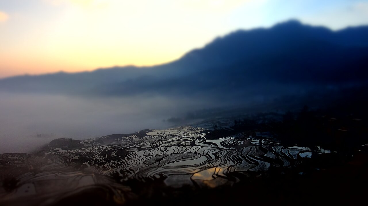
The Cultural Landscape of Honghe Hani Rice Terraces, inscribed by UNESCO in 2013, protects 16,603 hectares of sculpted mountain landscape on the southern slopes of the Ailao Mountain range in Yuanyang County, Honghe Prefecture, Yunnan Province — the physical expression of a Hani agricultural civilization that has farmed these terraces continuously for more than 1,300 years, producing the largest and most technically sophisticated human-made terraced landscape in East Asia and one of the most extensive in the world. The inscription’s Outstanding Universal Value rests on the Hani people’s management of a vertically integrated agro-ecological system operating across four altitude zones from mountain summit to valley floor: the forest zone (elevation 1,800–2,000 metres, preserved as water catchment, forbidden from clearing) → the Hani village zone (elevation 1,400–1,800 metres, concentrated in compact elevated villages above the terraces) → the rice terrace zone (elevation 600–1,400 metres, the sculpted agricultural landscape) → the river valley zone (below 600 metres, water collection and drainage). The four zones function as an integrated water management system maintained without pumped irrigation: forests generate precipitation and regulate stream flow, which descends through village water systems (domestic use, fish breeding), into the terrace network (gravity-fed rice paddies, terraced winter flooding for soil conditioning), and into the valley rivers below. The Hani people manage this system through a communal water allocation institution (the “wooden vat” system, a proportional gravity irrigation system regulated by carved wooden channels that has operated for over a millennium without formal engineering infrastructure) and a communal forest protection system encoded in Hani customary law and annual ritual calendar.
The Ailao Mountain terraced corridor: Yuanyang, Lüchun, Jinping, and Honghe South China Karst Yunnan · Three Parallel Rivers · Jianshui Ancient Town — 80 to 350 km
Eighty Kilometres west of the Honghe Hani Rice Terraces’ primary visitor zones (Yuanyang County, in the Duoyishu, Bada, and Laohuzui viewpoint cluster) by road (approximately 2 hours from Yuanyang County town to Jianshui via the G8511 Expressway through Mengzi), Jianshui Ancient Town (建水古城, Jianshui Gǔchéng, 45 km south of the Honghe expressway junction) is the most historically significant city in the Honghe Hani and Yi Autonomous Prefecture and the starting point for the Yunmeng Qu narrow-gauge steam railway, the vintage metre-gauge line (opened 1915, the Yunnan-Vietnam Railway’s branch from Biyuanfan Junction to Jianshui, originally built by the French Yunnan Railway Company under the colonial concession) that still runs tourist steam services between Jianshui and Tuanshan Village, crossing the stone-arch Shuanglong Bridge over the Yuanjiang River (a 17-arch Qing-dynasty bridge of 1795, one of the longest stone bridges in Yunnan). Jianshui’s Zhu Family Garden (朱家花园, 1894, a private courtyard compound of the Zhu merchant family, comprising 214 rooms arranged in 3 parallel courtyard sequences, considered the finest Ming-Qing private residential complex in Yunnan) and the Confucian Temple at Jianshui (the third-largest Confucian temple complex in China after Qufu and Beijing, built 1285 CE and expanded repeatedly through the Ming and Qing periods, still housing a working traditional school) are the primary historic monuments. From Kunming, Jianshui is reached by the Mengzi-Kunming HSR (approximately 1.5 hours from Kunming South to Jianshui North Station). From Jianshui, Yuanyang is reached by coach (approximately 3 hours south via the G8511 and provincial roads through Lüchun).
Two Hundred Kilometres northwest of the Honghe Hani Rice Terraces by road (approximately 3.5 hours from Yuanyang County town to Kunming via the G85 Expressway through Mengzi and Jianshui), Kunming City is the regional transport hub for all Yunnan UNESCO sites. The South China Karst’s Shilin Stone Forest component (inscribed 2007, 90 km southeast of Kunming) and the Chengjiang Fossil Site (inscribed 2012, 55 km southeast of Kunming) are accessible on the same road corridor southeast of Kunming. For visitors combining the Hani Rice Terraces with other Yunnan UNESCO sites, the practical circuit is: Kunming → Jianshui (1.5 hours by HSR, 1 night in Jianshui) → Yuanyang (3 hours by coach from Jianshui, 2 nights in Yuanyang) → Kunming (4.5 hours by coach from Yuanyang via Mengzi, or HSR from Jianshui) → Shilin or Chengjiang (day trip from Kunming). The Four-season Rice Terrace Circuit (the circuit combining Yuanyang’s four main viewpoints in different light conditions — Duoyishu at sunrise, Bada at sunset, Laohuzui for sunset panorama, Mengpin for close-up field detail) requires a minimum of 2 nights in Yuanyang to complete, as the optimal viewing conditions (flooded winter terraces, November–April) and the scattered road distances between viewpoints (Duoyishu to Laohuzui, approximately 35 km by mountain road) do not permit all four viewpoints in a single day.
Three Hundred and Fifty Kilometres north of the Honghe Hani Rice Terraces by road and rail (approximately 5 hours from Yuanyang to Lijiang via Kunming-Lijiang HSR — Yuanyang by coach to Mengzi HSR station approximately 2 hours, Mengzi HSR to Kunming approximately 45 minutes, Kunming to Lijiang approximately 2.5 hours on the Guiyang-Kunming-Kunming-Lijiang HSR extension), the Three Parallel Rivers of Yunnan Protected Areas (inscribed 2003) represent the same Yunnan-biodiversity-refugium landscape of which the Ailao Mountain rice terraces’ integrated agro-ecological system is the human-managed equivalent. The genetic diversity of the Hani rice varieties maintained in the Yuanyang terraces (the Hani people cultivate approximately 48 named traditional rice varieties in the Yuanyang terraces, adapted to different micro-elevation zones and terrace water depths) is directly analogous to the wild plant species diversity preserved in the Three Parallel Rivers’ Hengduan Mountain refugia — both represent biological diversity maintained through long-term spatial isolation and vertical ecological specialisation in the Yunnan mountain landscape. From Kunming, Lijiang and the Three Parallel Rivers are reached by the Kunming-Lijiang HSR (approximately 2.5–3 hours from Kunming South).
The Hani-Yi cultural corridor: Mengzi, Kaiyuan, and the Yunnan-Vietnam Railway Ancient Jianshui Town · Red River Valley · Stone Forest Shilin — 45 to 200 km
Forty-Five Kilometres north of Jianshui by road (approximately 45 minutes on the G8511 Expressway), Mengzi (蒙自市) is the prefectural capital of Honghe and the site where the Yunnan-Vietnam Railway was headquartered by the French colonial concession company (the Yunnan Railway Company, Compagnie française des chemins de fer de l’Indochine et du Yunnan, established 1901) during the construction period 1903–1910. The French Consulate building in Mengzi (a two-storey neoclassical brick structure, 1908, the oldest surviving European building in Mengzi) and the former Yunnan-Vietnam Railway station quarter (the station district with French-period warehouses, customs offices, and staff housing along the main track alignment) preserve the material culture of the colonial railway era that paradoxically funded the preservation of the Hani rice-terrace landscape — the railway’s opening in 1910 connected the previously isolated Honghe Valley to Yunnan markets, enabling the sale of Hani agricultural surplus and providing the economic base for continued terrace maintenance in the 20th century. The Honghe River itself (the Red River, Yuanjiang in Chinese, flowing from Dali through Yuanyang and across the Vietnam border to the Gulf of Tonkin) forms the geographic axis of the entire Hani rice-terrace landscape: the terraces are carved into the mountain slopes above the river’s southern (left) bank, and the gravity irrigation system is ultimately fed by the river’s moisture-laden air mass rising up the Ailao Mountain slopes in the afternoon. From Kunming, Mengzi is reached by the HSR (approximately 1.5 hours from Kunming South to Mengzi Station).
Practical information
The Cultural Landscape of Honghe Hani Rice Terraces covers four county-level administrative areas (Yuanyang, Lüchun, Jinping, and Honghe Counties) in Honghe Hani and Yi Autonomous Prefecture, Yunnan Province. The primary visitor access is via Yuanyang County, specifically the New Yuanyang Town (新街镇, Xinjiе Zhèn, located on the plateau above the terraces at elevation approximately 1,600 metres) as the accommodation base, with the four main terrace viewpoints accessible by tourist bus or hired car from New Town. The four main viewpoints are: Duoyishu (多依树, best at sunrise, 7 km east of New Town); Bada (坝达, best at sunset, 12 km north of New Town); Laohuzui (老虎嘴, best at sunset, 22 km west of New Town); Mengpin (勐品, close-up field detail, 18 km west of New Town). Best visiting season: December–April (winter flooding period), when the rice paddies are filled with water and create the landscape’s iconic mirror-reflection panorama at sunrise; the terraces are planted in May (flooded, green) and harvested September–October (golden). From Kunming, Yuanyang is reached by: (a) express coach from Kunming West Bus Station to Yuanyang, approximately 4.5 hours; (b) HSR to Jianshui North or Mengzi Station (approximately 1.5 hours) and then coach to Yuanyang (3 hours). The nearest airport is Mengzi Airport (approximately 2.5 hours from Yuanyang by road), with connections to Kunming and Guangzhou. Accommodation in New Town ranges from budget guesthouses (¥100–150/night) to boutique minority-culture hotels (¥400–600/night); the best sunrise viewpoints at Duoyishu require 5:00 AM departure from New Town.
Frequently Asked Questions
How do the Hani people maintain the terrace irrigation system without modern engineering infrastructure?
The Hani rice-terrace water management system — described by UNESCO as “a striking manifestation of an extraordinary land use system” — operates through a gravity-fed network of wooden irrigation channels (the “wooden vat” or mugua system) that distributes mountain spring water proportionally among the terrace holders in each irrigation catchment, without pumped infrastructure, meters, or formal engineering institutions. The system’s principle is hydraulic proportionality: the main wooden channel from the spring or stream source is divided at each branch point by a carved notch in the channel wall (the mugua, 木刮, or “wooden scraper”) that diverts water in a fixed ratio determined by the notch position — typically reflecting the historical land allotment of each Hani household. The mugua notch positions were established by the founding generation of each terrace cluster and transmitted as customary rights encoded in Hani oral tradition and village council records. Maintenance obligations (clearing silt from channels, repairing breaks, seasonal channel inspection) are allocated in proportion to water rights — the household receiving the largest water allocation has the largest maintenance obligation. The system is regulated seasonally by the water allocation ceremony (the “opening of the ditch” or kaiqu 开渠, held annually in the Hani lunar calendar spring), at which the village council allocates water rights for the coming season and mediates disputes between terrace holders. The communal forest protection system (the village sacred forest, muji di 木籍地, the stand of fir, walnut, and oak forest above the village that is protected from any cutting or clearing by Hani customary law under penalty of communal sanction) is the upstream component: the forest’s root system retains precipitation as groundwater and releases it gradually through the spring season, preventing both flood peaks and drought troughs in the terrace irrigation channels. Without the sacred forest cover, the terrace irrigation system would fail within a single dry season. The integrated forest-village-terrace-river system’s 1,300-year continuity is thus a product not of engineering sophistication but of institutional sophistication: the Hani community’s ability to maintain communal property rights, shared maintenance obligations, and sacred ecological protection across 60+ generations without state administrative support.
When is the best time to visit the Hani Rice Terraces and what are the different seasonal landscapes?
The Hani Rice Terraces offer a completely different visual experience in each season, and the selection of visiting period depends on what aspect of the landscape the visitor is most interested in. The winter flooding period (November–April, approximately) is the most photographically iconic: after the October harvest, the Hani farmers flood the terraces with irrigation water from the mountain springs for soil conditioning and fish cultivation, creating a landscape of thousands of cascading mirror-ponds reflecting sky, clouds, and the silhouettes of Hani villages above. The early morning period during the flooding season (5:00–8:00 AM) at the Duoyishu viewpoint, when cold mountain mist fills the lower terrace zones while the upper terraces catch horizontal sunlight, produces the image that has made the Yuanyang terraces internationally famous — a landscape that appears simultaneously architectural and natural, where the stepped geometry of the human-made terraces dissolves into the organic forms of the morning mist. The planting season (May–June) is the most culturally active: the Hani planting ceremonies (the Ku Zha Zha festival, held in the sixth month of the Hani lunar calendar, involving communal terrace preparation, ritual sacrifice, and planting songs) take place at this period, and the newly planted terraces reflect a brilliant green against the red Ailao Mountain soil at the terrace borders. The growing season (July–September) is the most conventionally agricultural: the terraces fill with dense green rice growth, the bird life of the terraced wetlands is most active (the water buffalo working the lower terraces, the grey herons stalking the flooded paddies, the white egrets following the plows), and the harvest season (September–October) is golden. The dry season (February–March, before the spring rains) can create fog conditions in the afternoon that fill the valley and produce a cloud-sea effect visible from the elevated viewpoints. All seasons have distinct visual character; the winter flooding season (November–March) is optimal for the landscape’s most famous visual effects but also has the heaviest tourist congestion at the main viewpoints.
What is the relationship between the Hani people and the rice terrace landscape and how is traditional Hani culture maintained today?
The Hani people (哈尼族, Hani Zu) are one of China’s 56 officially recognised ethnic minority groups, with a population of approximately 1.66 million in Yunnan Province (2020 census), concentrated in the Honghe, Pu’er, and Xishuangbanna prefectures of southern Yunnan. The Hani are closely related to the Yi people (both Tibeto-Burman language groups of the Lolo branch) and migrated southward into the Ailao Mountain region from the Tibetan Plateau approximately 1,000–1,500 years ago, at which point — according to Hani oral tradition recorded in the Hani epic Hani Amu Jiumu — they began transforming the Ailao Mountain slopes from forest to rice terrace. The Hani rice-cultivation system requires a specific combination of mountain topography (steep slopes with reliable mountain springs), soil type (the red laterite soils of the Ailao Mountain that hold water well), and climate (subtropical monsoon with reliable summer rainfall and warm winters that prevent frost damage to winter-flooded terraces). The cultural expression of the Hani’s relationship to the terrace landscape is encoded in their music (the Hani Ba La Hui communal music and dance tradition, held in the seventh month of the Hani lunar calendar, in which women perform circle dances in embroidered traditional costume while men play the zanzhan single-reed mouth organ), in their festivals (the Ku Zha Zha planting festival, the Hani New Year Zha Le Te Zha, held at the winter solstice, when the entire village prepares the year-end ritual meal in the village square), and in the Hani language’s extraordinarily rich vocabulary for rice cultivation — the Hani language distinguishes approximately 160 named types of rice cultivation activity (soil preparation, water management, transplanting, weeding, pest management, harvest) and approximately 48 named rice varieties, each with specific altitude and water-depth requirements. Contemporary threats to the traditional system include migration of working-age Hani villagers to urban employment (leaving terraces maintained by elderly farmers or abandoned), encroachment of commercial tea and rubber cultivation (both more profitable per hectare than rice), and tourism pressure on the most accessible viewpoint areas (where guesthouse construction and vehicle traffic erode the terrace embankments). UNESCO’s 2013 inscription has provided the institutional framework for the Chinese government’s terrace maintenance subsidies (direct payments to Hani households maintaining traditional cultivation practices) and tourism revenue-sharing schemes (a 25% accommodation tax surcharge directed to the Hani Heritage Management Committee).
Sources
- S1 — UNESCO World Heritage Centre — Cultural Landscape of Honghe Hani Rice Terraces (Ref. 1111) — https://web.archive.org/web/20230601000000/https://whc.unesco.org/en/list/1111/
- S2 — UNESCO World Heritage Centre — Statement of Outstanding Universal Value (Ref. 1111) — https://whc.unesco.org/en/list/1111/
Spotted an error? Write to editorial@culturalheritageonline.com and we correct it the same day.