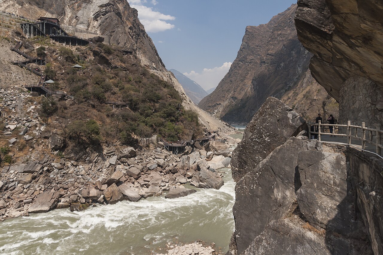
The Three Parallel Rivers of Yunnan Protected Areas, inscribed by UNESCO in 2003, is the largest and most geologically complex protected area in China: 1,700,000 hectares of northwest Yunnan Province where the upper reaches of three of Asia’s most important rivers — the Yangtze (Jinsha Jiang), the Mekong (Lancang Jiang), and the Salween (Nu Jiang) — run parallel courses separated by no more than 66 kilometres through a series of deep mountain gorges, forming one of the most biologically diverse temperate zones on earth. The gorges reach depths of 3,000 metres (Tiger Leaping Gorge on the Jinsha River is 3,900 metres from river surface to the summit of the Haba Snow Mountain above it) between mountain ranges whose peaks exceed 6,700 metres (Kawagarbo/Meili Snow Mountain at 6,740 metres is the highest peak in Yunnan Province); the altitudinal range across the protected area — from subtropical river valleys at 760 metres to arctic-alpine peaks at 6,740 metres — compresses a latitudinal range equivalent to crossing from the tropics to the Arctic within a horizontal distance of 60 kilometres. This extreme vertical and horizontal compression produces the exceptional biodiversity that defines the Three Parallel Rivers’ Outstanding Universal Value: 6,000+ plant species (25% of China’s total), 777 bird species (approximately 70% of China’s total), 132 mammal species, 59 endemic species found nowhere else on earth, and 5 of the world’s 8 biogeographical zones represented within a single protected area boundary.
Northwest Yunnan: the Tibetan borderland and the ancient tea-horse road Lijiang Old Town · Shangri-La Zhongdian · Sichuan Giant Pandas — 50 to 400 km
Fifty kilometres south of the Three Parallel Rivers’ Hengduan Mountain zone by road (approximately 1.5 hours from Lijiang Old Town north toward the Jade Dragon Snow Mountain and the Tiger Leaping Gorge trailhead), the Old Town of Lijiang (inscribed 1997) is the starting point for most visitors to the Three Parallel Rivers protected area and the historic trading centre of the Naxi ethnic minority whose agricultural civilisation developed at the junction of the Yunnan plateau and the Hengduan Mountain gorge zone. The Naxi people’s Dongba script — the only pictographic writing system still in active use in the world, maintained by a lineage of Dongba (shaman-scribes) who use it to record the Naxi traditional religious texts — was developed specifically for the mountain-forest landscape that the Three Parallel Rivers protected area documents: the Dongba cosmology treats the rivers, mountains, and wildlife of the Hengduan zone as the living landscape of the Naxi spirit world. Tiger Leaping Gorge (Hutiao Xia), the most dramatic single landscape feature of the Three Parallel Rivers area, begins approximately 60 kilometres northeast of Lijiang Old Town and is the standard introduction to the gorge landscape for visitors using Lijiang as a base: the 15-kilometre trekking trail through the gorge (high path, 2 days from Qiaotou to Walnut Garden) is one of the most celebrated hiking routes in China, combining the river’s gorge scenery with views of the Haba Snow Mountain (5,396 metres) and the Jade Dragon Snow Mountain (Yulong Xueshan, 5,596 metres). From Lijiang, Tiger Leaping Gorge is reached by bus from Lijiang Bus Station to Qiaotou (approximately 1.5 hours).
One hundred Fifty kilometres north of Lijiang by road (approximately 3 hours from Lijiang to Shangri-La City, Zhongdian, on the G214 National Highway, climbing from 2,400 metres to 3,300 metres), the Zhongdian area (renamed Shangri-La in 2001 as a tourism marketing decision based on its identification with the valley described in James Hilton’s 1937 novel “Lost Horizon”) is the gateway to the Tibetan-plateau highland that forms the northern section of the Three Parallel Rivers protected area. Shangri-La City (Zhongdian) contains the Songzanlin Monastery (Ganden Sumtseling, founded 1679 CE, the largest Tibetan Buddhist monastery in Yunnan Province, with 1,500 monks and six assembly halls modelled on the Potala Palace in Lhasa) and the Potatso National Park (Pudacuo National Park, established 2007 within the Three Parallel Rivers UNESCO area), which provides accessible visitor infrastructure for experiencing the high-altitude lake and meadow ecosystem of the Zhongdian Plateau — blue Lake Bita Hai (3,538 metres), the Shudu Lake (3,705 metres wetland), and the subalpine meadow (dugeng) walking circuits. From Lijiang, Shangri-La is reached by road (approximately 3 hours) or by the Lijiang-Shangrila line (reconstruction ongoing, scheduled 2025) when the highland railway is operational. Shangri-La also has domestic airport connections to Kunming, Chengdu, and Chongqing.
Two hundred Kilometres west of the Three Parallel Rivers’ Nu River (Salween) gorge by road (approximately 3 hours from Baoshan City to the Nu River Valley visitor areas on the G56 Expressway west and then the S314 north toward Gongshan), the Nu River Valley (Nujiang) is the most isolated and least visited of the three gorges — a 316-kilometre valley road tracing the Salween River’s Yunnan course through Nujiang Lisu Autonomous Prefecture, whose indigenous Lisu, Nu, Drung, and Tibetan ethnic minority communities maintain traditional mountain agriculture and a subsistence economy on the narrow terrace land between the river and the cliff faces. The Nu River gorge (depth 2,000–3,000 metres between the Gaoligong and Biluoxue mountain ranges flanking it) was historically proposed for construction of a 13-dam hydroelectric cascade that would have destroyed the gorge ecosystem and displaced approximately 50,000 people from indigenous communities; the dam project was suspended in 2004 by Premier Wen Jiabao following UNESCO’s inscription of the area and is periodically revived in modified form. The Nu River Valley road is the most challenging visitor access in the Three Parallel Rivers system — no high-speed rail, limited paved roads, and remoteness that requires 3–5 days to explore adequately — making it the authentic wilderness counterpart to the more accessible Tiger Leaping Gorge and Shangri-La components. From Lijiang or Shangri-La, the Nu River Valley is accessible by long-distance bus (via Liuku and Gongshan, 2–3 days for the full valley road) or by flight to Baoshan and then bus north.
Three Hundred Kilometres east of the Three Parallel Rivers protected area by road and high-speed rail (approximately 2.5 hours from Lijiang to Dali by road, then 2 hours from Dali by HSR to Kunming South), the Yuanmou Man Site (Homo erectus fossil site, approximately 1.7 million years old, in Yuanmou County, Chuxiong Prefecture, not UNESCO-inscribed) and the Yunnan Stone Forest (part of the South China Karst inscription, 2007, 90 km southeast of Kunming) are accessible from the same Yunnan highland plateau. Kunming City, Yunnan’s capital, is the regional transportation hub: the Kunming-Hekou HSR (completed 2016) connects to Hanoi; the Zheng-Kun (Zhengzhou-Kunming) HSR (under construction, due 2027) will connect Kunming to the central China network; and Kunming Changshui International Airport serves as the primary air gateway to the Three Parallel Rivers area. From Kunming, the South China Karst’s Shilin Stone Forest component is accessible by metro Line 5 and suburban rail to Shilin Station (approximately 1 hour), providing a limestone karst landscape comparison with the sandstone-and-granite gorge landscape of the Three Parallel Rivers. From Lijiang, Kunming is reached by HSR (approximately 2.5 hours from Lijiang South Station to Kunming South on the Dali-Kunming HSR).
South into Yunnan’s tropical zone and east toward the Yangtze headwaters South China Karst Shilin · Mount Qingcheng Chengdu · Dali Bai culture — 200 to 500 km
Two Hundred Kilometres south of the Three Parallel Rivers area by road (approximately 3 hours from Lijiang to Dali on the G56 Expressway south), the ancient capital of the Nanzhao Kingdom (738–902 CE) and the Dali Kingdom (937–1253 CE) at Dali City — not separately UNESCO-inscribed — represents the other major pre-Han ethnic culture of the Yunnan highland that coexisted with the Three Parallel Rivers’ indigenous Naxi, Nu, and Tibetan communities. The Dali Bai culture and the Nanzhao Kingdom, whose capital was at Dali from the 8th through 13th centuries, developed a sophisticated Esoteric (Tantric) Buddhist tradition (Azhali Buddhism) and a stone-carving programme documented in the Chongsheng Temple (Chong Sheng Si) Three Pagodas — three Tang-period brick pagodas (the Qianxun Pagoda, 69.13 metres, built 824–859 CE; the north and south pagodas, approximately 42 metres, built 10th century) that are the oldest major Buddhist monuments in Yunnan Province and document the same Tang Buddhist cultural wave that produced the Longmen Grottoes in Henan. From the Three Parallel Rivers’ southern edge (Lijiang), Dali is reached by road (approximately 2.5 hours) or HSR from Lijiang South to Dali Station (approximately 30 minutes).
Five Hundred Kilometres northeast of the Three Parallel Rivers protected area by road and high-speed rail (approximately 2.5 hours from Lijiang to Kunming, then 2 hours from Kunming to Chengdu East on the Chengdu-Kunming HSR under construction, or approximately 5 hours by current rail), the Mount Qingcheng and Dujiangyan Irrigation System (inscribed 2000) and the Sichuan Giant Panda Sanctuaries (inscribed 2006) represent the two Sichuan UNESCO inscriptions most directly connected to the Three Parallel Rivers’ ecological significance. The Three Parallel Rivers protected area is classified as the primary dispersal route for plant and animal species between the tropical Southeast Asian zone (to the south), the Tibetan Plateau (to the north and west), and the Chinese subtropical zone (to the east) — a biological bridge whose importance was determined by the fact that, during the Pleistocene ice ages (2.6 million–11,700 years ago), the Three Parallel Rivers gorges remained ice-free refugia that preserved tropical and subtropical species while the surrounding plateaux were glaciated. The giant panda (Ailuropoda melanoleuca), whose range is centred on the Sichuan highland zone northeast of the Three Parallel Rivers, is believed by palaeoecologists to have survived the Pleistocene glaciations partly through the use of the Three Parallel Rivers’ Hengduan Mountain zone as a refugium corridor connecting the Sichuan bamboo forests to the south. From Kunming, Chengdu is most efficiently reached by flight (approximately 1.5 hours) until the Chengdu-Kunming HSR is completed.
Three Hundred Kilometres southeast of the Three Parallel Rivers protected area by road and rail (approximately 4 hours from Lijiang to the Lugu Lake area via the Sichuan border, or approximately 6 hours to Xichang in Sichuan Province), the Lugu Lake highland plateau (3,000 metres) on the Yunnan-Sichuan border hosts the Mosuo people — the best-documented matrilineal society in China, in which inheritance, property, and clan identity pass through the female line, and the “walking marriage” (zouhun) tradition allows women to maintain autonomous households while male partners “walk” to the woman’s home rather than forming a shared household. The Mosuo culture’s survival is related to the geographical isolation of the Lugu Lake plateau, which was protected from the Han Chinese administrative integration that transformed other Yunnan minority cultures by the same gorge-and-mountain topography that defines the Three Parallel Rivers protected area. The Lugu Lake area is not UNESCO-inscribed but is on China’s Tentative List; it is typically combined with the Three Parallel Rivers visit as an extension from Lijiang (Lugu Lake is 9 hours by road from Lijiang via the Xichang road, requiring an overnight).
Practical information
The Three Parallel Rivers protected area covers 1,700,000 hectares of northwest Yunnan Province, divided into eight geographic sub-areas (Gaoligong Mountain, Red Rock Mountains, Qianhu Mountain, Laojun Mountain, Baimang-Meili Mountain, Haba Snow Mountain, Nujiang Greater Gorge, and Hongshan). Visitor access is primarily through Lijiang (for the Jinsha River / Tiger Leaping Gorge component and the Yulong Snow Mountain), Shangri-La (for the Meili Snow Mountain and Pudacuo National Park components), and Gongshan County (for the Nu River gorge component). Lijiang Sanyi International Airport (LJG) is the primary air gateway, with daily flights to Kunming (40 minutes), Chengdu (1.5 hours), and Chongqing (2 hours); Shangri-La Diqing Airport (DIG) serves Kunming and Chengdu. High-speed rail from Kunming to Lijiang (via Dali) takes approximately 2.5 hours; from Chengdu to Lijiang, currently 8+ hours by conventional rail (the Sichuan-Yunnan Railway under construction will reduce this significantly). Visitor access to the tiger leaping gorge trekking route (high path, approximately 15 km, 2 days, starting from Qiaotou) requires no permit; permits are required for the Pudacuo National Park (Shangri-La) and for crossing the Meili Snow Mountain circuit. The best visiting season is April–October; July–August brings monsoon rain to the lower valleys while the high passes may receive snow at any month. The autumn season (September–October) offers the clearest mountain views and the best Meili Snow Mountain morning alpenglow photography conditions. Altitude acclimatisation is required for Shangri-La (3,300 metres), the Meili Snow Mountain base (3,500+ metres), and any high-altitude trekking routes above 4,000 metres.
Frequently Asked Questions
Why do three major Asian rivers run parallel in such a small geographic area?
The Three Parallel Rivers’ extraordinary geography — the Jinsha (upper Yangtze), Lancang (upper Mekong), and Nu (upper Salween) rivers running parallel north-to-south courses within a maximum separation of 66 kilometres in northwest Yunnan — is the result of the Himalayan orogeny, the tectonic process that began approximately 50 million years ago when the Indian subcontinent collided with the Eurasian plate. The collision forced the Tibetan Plateau upward while simultaneously compressing the eastern edge of the plateau — the Hengduan Mountain zone — into a series of north-south oriented fold-and-thrust belts. The rivers’ north-south courses are inherited from pre-Himalayan drainage systems that carved southward-flowing channels through the highland before the mountains rose; as the mountains rose around them, the rivers maintained their courses by cutting downward fast enough to keep pace with the uplift — a process called “antecedent drainage.” The result is rivers that are older than the mountains they flow through: the Jinsha, Lancang, and Nu carved their current gorges progressively deeper as the Hengduan Mountains rose around them, producing the 3,000-metre depth differentials visible today. The 66-kilometre separation between the three rivers represents the width of the three separate tectonic belts — the Gaoligong belt (between the Nu and Lancang), the Nujiang belt (between the Lancang and Jinsha), and the Jinsha belt (east of the Jinsha) — each of which represents a separate phase of the Himalayan collision’s eastward-moving thrust front. The rivers will continue cutting deeper for millions of years as long as the tectonic compression continues: the gorges are still deepening at approximately 1–2 millimetres per year.
What is the biodiversity significance of the Three Parallel Rivers and why is it called a “global centre of biodiversity”?
The Three Parallel Rivers protected area is classified by the UNESCO nomination as containing an exceptional overlap of three global biodiversity categories: it contains 20 of China’s 25 plant genera considered globally significant, 25% of the world’s animal species found in the Northern Hemisphere, and the most complete altitudinal transect of vegetation zones (from subtropical dry valley at 760 metres through temperate broadleaf forest, subalpine conifer forest, alpine meadow, and permanent snow and ice above 5,000 metres) found anywhere in Asia’s temperate zone. The protected area’s biodiversity results from the same geological process that produced its gorge topography: because the Hengduan Mountain zone remained partially unglaciated during the Pleistocene ice ages (the orientation of the gorges funnelled warm monsoonal air northward, maintaining ice-free refugia in the lower valley floors even during glacial maxima), it served as a refuge for plant and animal species that were exterminated from the glaciated surrounding zones. When the glaciers retreated, the refugia species recolonised the newly available territory — but the deep gorges also acted as physical barriers, preventing the recolonising species from the different refugia from mixing. The result is extreme local endemism: species that evolved in isolation during the glacial periods in one gorge are often found only in that gorge, with closely related species in adjacent gorges. The UNESCO inscription’s 777 bird species count makes the area equal in bird species richness to the entire European continent; the 6,000+ plant species count exceeds the total flora of the British Isles. The conservation challenge is significant: the same mountain geography that protected the biodiversity from glaciation now exposes it to the rapidly advancing road and hydroelectric infrastructure of southwestern China’s development programmes.
What is the Dongba script and why is it unique in the world?
The Dongba script (Dongba wen, 东巴文) is the pictographic writing system of the Naxi people, used by Dongba (shaman-priests, 东巴, literally “wise men”) to record the Naxi traditional religion’s ritual texts — a corpus of approximately 20,000 hand-written manuscript volumes (dongba classics) now held primarily in the Yunnan Provincial Museum, the Lijiang Naxi Culture Research Centre, and collections at Harvard, Library of Congress, and the Nationalbibliothek in Vienna. The script is classified as the only living pictographic writing system in the world: it is still read and written by approximately 100 active Dongba practitioners, all of whom have been trained in the traditional apprenticeship system (training begins in childhood and requires approximately 15 years of study to master the full corpus). The script’s uniqueness lies in its representational logic: unlike all other surviving writing systems (which are either alphabetic/phonetic, syllabic, or logographic), the Dongba script uses approximately 1,400 individual pictographs that represent concepts, objects, and actions directly — a bird-drawing represents “bird,” a person-with-tree represents “to shelter/protect,” a person-crying-with-sun-behind represents “regret/nostalgia” — without a consistent sound-correspondence system that would make it phonetically decipherable by a reader unfamiliar with the content. The script’s survival is therefore entirely dependent on the oral tradition of Dongba ritual performance: a Dongba reads the text not by phonetically decoding the pictographs but by using the pictographs as memory prompts for ritual chants memorised in an oral tradition. The script’s most culturally significant function is its documentation of the Naxi relationship with the natural landscape: the Dongba cosmology treats the mountain peaks, rivers, and wildlife of the Hengduan zone as spirit beings with whom humans must maintain ritual relationships — a worldview that provides the indigenous cultural framework for the same landscape that the Three Parallel Rivers inscription designates as a natural heritage site.
Sources
- S1 — UNESCO World Heritage Centre — Three Parallel Rivers of Yunnan Protected Areas (Ref. 1086) — https://web.archive.org/web/20230601000000/https://whc.unesco.org/en/list/1086/
- S2 — UNESCO World Heritage Centre — Statement of Outstanding Universal Value (Ref. 1086) — https://whc.unesco.org/en/list/1086/
Spotted an error? Write to editorial@culturalheritageonline.com and we correct it the same day.