
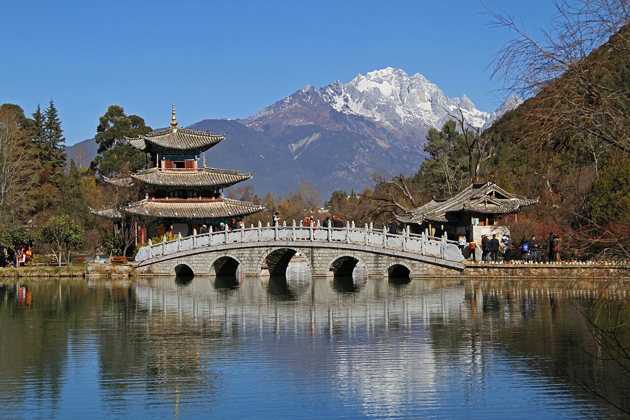
The Old Town of Lijiang (Dayan Old Town), inscribed by UNESCO in 1997 as a cultural World Heritage Site, is a remarkably preserved ancient trading town in Lijiang Naxi Autonomous County, northwestern Yunnan Province, founded in the Song-Yuan period (12th–13th centuries) by the Naxi people — a Tibeto-Burman ethnic minority with a unique pictographic writing system (Dongba script) and a matrilineal social tradition. The town covers 3.8 square kilometres at 2,400 metres altitude and is organised around a network of stone-paved lanes, canals fed by the Jade River (Yu River), and traditional timber-framed courtyard houses; it is notable among Chinese ancient towns for the absence of a city wall (unique among major Chinese historic towns) and for the fact that the urban grid follows the topography rather than the Confucian cardinal-direction grid plan. The inscription also includes the related Shuhe Old Town, a smaller Naxi settlement 4 kilometres northwest that predates Dayan.
Northwest Yunnan UNESCO corridor Three Parallel Rivers · Chengjiang Fossil Site · Dali — 100 to 500 km
One hundred to two hundred kilometres north of Lijiang by road (approximately 2–4 hours via the G214 National Road through the Jinsha River valley gorges), the Three Parallel Rivers of Yunnan Protected Areas (inscribed 2003) begin in the deep gorge zone where the Jinsha (upper Yangtze), Lancang (Mekong), and Nu (Salween) rivers run within 50–80 kilometres of each other through the Hengduan Mountain chain. Lijiang sits in the first major basin downstream from the Three Parallel Rivers gorge zone: the Jinsha River’s canyon above Lijiang (the Tiger Leaping Gorge, Hutiao Xia, approximately 60 kilometres north of Lijiang city) is the most famous section of the gorge system accessible to trekkers, with the river narrowing to 30 metres and dropping 213 metres over 16 kilometres in a white-water section confined by the 3,200-metre Haba Snow Mountain and the 5,596-metre Jade Dragon Snow Mountain on either side. The Tiger Leaping Gorge is not within the UNESCO inscription boundary (the Three Parallel Rivers inscription’s southern components begin approximately 100 kilometres north of Lijiang) but is within the inscription’s watershed and provides the closest accessible encounter with the gorge landscape. From Lijiang, the Tiger Leaping Gorge is reached by bus to Qiaotou village and 2-day trekking circuit, or by road to the lower gorge viewing platform (approximately 1.5 hours).
Two hundred kilometres northwest of Lijiang by road (approximately 3 hours via the Lijiang-Shangri-La Expressway), the city of Shangri-La (Zhongdian, Yunnan Province) and the Pudacuo National Park bring visitors into the Tibetan cultural zone adjacent to the Three Parallel Rivers inscription. Shangri-La — renamed from Zhongdian in 2001 to capitalise on James Hilton’s fictional “Shangri-La” (from the 1937 novel Lost Horizon, reportedly inspired by Joseph Rock’s 1924–1935 National Geographic reports on the Nakhi/Naxi and Tibetan communities of the Lijiang area) — is the primary access point for the Three Parallel Rivers’ Pudacuo component, the most accessible of the inscription’s eight sections: a 602-square-kilometre protected area with wetlands, lakes (Bita and Shudu lakes at 3,500 metres), Tibetan grassland, and alpine forest. The Ganden Sumtseling Monastery at Shangri-La (Tibet’s largest Tibetan Buddhist monastery in Yunnan, founded 1679, housing approximately 700 monks, largely rebuilt after 1981) is the cultural centre of the Tibetan community of the Lijiang-Shangri-La corridor. From Lijiang, Shangri-La is reached by bus (approximately 3 hours) or by shuttle from Lijiang Sanyi International Airport.
One hundred sixty kilometres southeast of Lijiang by road (approximately 2.5 hours via the Lijiang-Dali Expressway), the city of Dali and the Erhai Lake basin provide the nearest major cultural complement to Lijiang’s Naxi heritage in the Yunnan highlands. Dali (altitude 1,900 metres) was the capital of two major Yunnan kingdoms — the Nanzhao Kingdom (738–902 CE) and the Dali Kingdom (937–1253 CE) — which controlled the trade routes between China, Tibet, and Southeast Asia that Lijiang’s Naxi traders participated in. The Three Pagodas of Chongsheng Monastery at Dali (9th century, the tallest 69 metres) are among the oldest surviving Chinese pagodas in southwestern China; the Dali town itself (the Xizhou and Zhoucheng Bai ethnic minority villages in the Erhai basin) preserves the Bai cultural tradition of white-walled courtyard houses with elaborate painted-stone gate frames. Dali is not a UNESCO World Heritage Site but was on China’s preliminary list; its cultural significance for the Yunnan highland trade-route heritage is complementary to Lijiang’s Naxi inscription. From Lijiang, Dali is reached by expressway (approximately 2.5 hours) or by direct high-speed rail (Lijiang to Dali, approximately 1 hour, via the Dali-Lijiang Railway).
Four hundred kilometres southeast of Lijiang by road (approximately 5 hours via Dali and Kunming), the South China Karst UNESCO inscription (inscribed 2007, extended 2014) covers components in Yunnan (the Shilin Stone Forest component, 90 kilometres southeast of Kunming) and other provinces. The Shilin Stone Forest (Yunnan Stone Forest) — a 350-square-kilometre karst field of grey limestone formations eroded into densely packed spires, pillars, and labyrinths at 1,800 metres altitude — represents the Yunnan geological context that the Lijiang cultural landscape overlies. Both Lijiang and the Shilin Stone Forest are in the Yunnan highland zone of the South China Karst geological system; the Sani Yi ethnic minority community at the Shilin Stone Forest (who perform the annual Torch Festival there) are cultural kin to the Naxi of Lijiang in the broader Yunnan ethnic mosaic. From Lijiang, the Shilin Stone Forest requires road travel to Kunming (approximately 5 hours) and then local bus or taxi (approximately 1 hour).
Connected by rail and river south and east Yuanyang terraces · Chengjiang Fossil Site · Ancient Town of Honghe — 400 to 800 km
Four hundred kilometres south of Lijiang by road (approximately 6 hours via Kunming to the Honghe Hani area), the Cultural Landscape of Honghe Hani Rice Terraces (inscribed 2013) documents the most extensive hand-carved agricultural landscape in China: 16,603 hectares of multi-layered rice terraces cut into the Ailao Mountains above the Honghe River valley in southern Yunnan, maintained by the Hani ethnic minority over 1,300 years. The visual and conceptual connection between the Naxi Lijiang inscription and the Hani Honghe terraces is the Yunnan ethnic minority agricultural landscape tradition: while the Naxi of Lijiang were primarily traders and artisans (the Lijiang market nexus was the commercial pivot of the Tea Horse Road), the Hani of Honghe maintained a subsistence agricultural system of extraordinary engineering complexity — 82 villages built between the water source (the mountain forests) and the rice terraces below, with a four-layer ecological system of forest-village-terrace-river that has operated without significant intervention since the Tang period. The two inscriptions together document the complementary economic strategies of the Yunnan highland minorities: trading culture at Lijiang, agricultural culture at Honghe. From Lijiang, the Honghe Hani terraces require road travel to Kunming and then south (approximately 6 hours total).
Four hundred kilometres southeast of Lijiang by high-speed rail (approximately 3 hours via the Dali-Kunming HSR and then to Chengjiang), the Chengjiang Fossil Site (inscribed 2012) in Yuxi City, Yunnan Province, is the world’s best-preserved Cambrian-period fossil site: approximately 520-million-year-old soft-bodied marine organisms preserved in fine-grained mudstone on the shore of Fuxian Lake, including representatives of virtually all major animal body plans (the Cambrian explosion). The Chengjiang fauna — 228 species documented, including soft-bodied arthropods, primitive chordates (including Pikaia-like species, the earliest known chordate ancestor), and predatory anomalocaridids — are preserved with three-dimensional soft tissue detail unprecedented in the global fossil record for Cambrian-period organisms. The geological and biological distance between Lijiang’s 12th-century Naxi town and the 520-million-year-old Chengjiang marine fossils is the complete span of animal evolution from the Cambrian “big bang” of body-plan diversification to the human cultural landscape that the Naxi people built at 2,400 metres altitude. From Lijiang, Chengjiang is reached by high-speed rail via Kunming (approximately 3 hours total).
Six hundred kilometres northeast of Lijiang by high-speed rail (approximately 4 hours via Kunming and Guiyang), the South China Karst’s Guizhou components — the Libo Karst (cone karst, inscribed 2007) and the Shibing Dolomite Karst (pinnacle karst, inscribed 2014) — document the most diverse karst morphologies in southern China. The Guizhou karst heritage and the Yunnan heritage of which Lijiang is the most prominent site are connected by the same geological platform: the Guizhou-Yunnan Plateau, a Precambrian metamorphic basement overlain by thick Triassic and Permian carbonate sequences, which produces both the dolostone karst of Guizhou and the limestone karst of Yunnan (including the Shilin Stone Forest near Kunming). From Lijiang, Guizhou’s karst components are accessible by high-speed rail through Kunming and Guiyang (approximately 5–6 hours total), making a Yunnan-Guizhou heritage itinerary practical as a multi-day circuit.
Eight hundred kilometres north of Lijiang by air (approximately 1.5 hours from Lijiang Sanyi Airport to Chengdu, then to Jiuzhaigou), the Jiuzhaigou Valley (inscribed 1992) and the Huanglong Scenic Area (inscribed 1992) in Sichuan Province are the most scenically comparable natural inscriptions to the Lijiang area within the Hengduan Mountain system. Lijiang sits at the southern base of the same Hengduan Mountain chain (the Min-Qionglai-Hengduan system) that Jiuzhaigou occupies at its northern end; Jade Dragon Snow Mountain (5,596 metres) above Lijiang and the Jiuzhaigou Min Mountains (highest point, Xuebao Ding, 5,588 metres) are at opposite ends of the same orogenic belt. The cultural-ecological gradient from Lijiang’s ancient Naxi town at 2,400 metres to Jiuzhaigou’s alpine lake system at 3,100 metres documents the full human and natural landscape of the Hengduan system from its cultural settlements to its pristine mountain interior.
Practical information
Lijiang is served by Lijiang Sanyi International Airport (LJG), which has direct flights from Kunming (approximately 45 minutes), Chengdu (approximately 1 hour), Shanghai (approximately 3 hours), Beijing (approximately 3.5 hours), Guangzhou (approximately 2.5 hours), and Chongqing (approximately 1.5 hours). High-speed rail connects Lijiang to Dali (approximately 1 hour) and then to Kunming South (approximately 2.5 hours) and to Guiyang North (approximately 4.5 hours via Kunming) on the Yunnan-Guizhou HSR. The old town of Dayan (the primary UNESCO-inscribed area) is approximately 10 kilometres from the airport by taxi or bus (approximately 25 minutes). The old town is car-free within its historic core; all movement is on foot along the stone-paved lane network. The commercial density in the old town has increased dramatically since the 1997 UNESCO inscription: the traditional courtyard houses along Sifang Street (the main market square) and the primary tourist lanes are now almost entirely converted to shops, bars, and guesthouses, with the original resident population largely relocated to the new town (Gulou Street area). The most intact residential fabric survives in the east old town away from the Sifang Street axis and in the adjacent Shuhe Old Town 4 kilometres northwest (also inscribed). The Dongba Cultural Museum on the western edge of the old town documents the Naxi Dongba (shamanic priest) tradition and the Dongba pictographic script. The Black Dragon Pool Park, at the northern edge of the old town, provides the standard view of Jade Dragon Snow Mountain reflected in the pool with the pavilion in the foreground. Jade Dragon Snow Mountain (Yulong Xueshan, 5,596 metres) is accessible from Lijiang by cable car to the glacier at 4,506 metres (30 minutes from the cable car base, 25 kilometres from Lijiang); altitude sickness is common at the glacier viewpoint.
Frequently Asked Questions
Who are the Naxi people and what is their Dongba script?
The Naxi (also spelled Nakhi or Nakhi) are a Tibeto-Burman-speaking ethnic minority of approximately 350,000 people concentrated in the Lijiang area of northwestern Yunnan and in the adjacent Sichuan-Tibet border zone. Their name means “black people” in their own language (na = black, xi/khi = people), a self-designation not related to skin colour but to a clan identity system. The Naxi cultural tradition is documented by the Dongba script — a pictographic writing system of approximately 1,400 symbols representing objects, actions, and concepts through stylised depictions rather than through sound-based phonetic conventions. The Dongba script is one of the world’s last living pictographic writing systems (as opposed to purely phonetic or logographic systems): the symbols are used exclusively by the Dongba (the shamanic priests of the Naxi community) for ritual and cosmological texts, and are not a general-purpose writing system for everyday communication (which has historically used Chinese characters or oral tradition). Approximately 20,000 Dongba manuscripts have been collected from the Lijiang area and are held in libraries in China, the United States (the Library of Congress and Harvard-Yenching Library hold significant collections), Switzerland, Germany, and Japan, reflecting the collecting activity of Western scholars from the 1890s through the 1940s (especially Joseph Rock, the Austrian-American explorer and botanist who lived in the Lijiang area from 1922 to 1949 and assembled the largest single Dongba manuscript collection, now at the Library of Congress). The Dongba tradition of ritual performance, manuscript writing, and cosmological painting — the “Dongba paintings” depicting the pantheon of deities and the cosmological narrative of creation and destruction — is maintained by a decreasing number of trained Dongba priests; UNESCO included the Dongba manuscripts in its Memory of the World Register in 2003.
Why does Lijiang have no city wall, unlike other major Chinese historic towns?
The Old Town of Lijiang is notable in Chinese architectural history for the absence of the defensive wall that defines most Chinese historic towns of equivalent importance: the town grew to a population of 25,000–30,000 in the Ming-Qing period without building the standard perimeter wall. The explanations offered in the Naxi and Chinese scholarly traditions are multiple. The traditional Naxi explanation recorded in Dongba texts is that the town’s name in Chinese characters contains the element “water” (the character 丽 Lì contains a water radical), and that water cannot be confined within walls — a cosmological reasoning rooted in the Naxi understanding of the town’s Jade River canal network as the site’s defining feature. A more practical historical explanation is that the Mu family (the ruling Naxi chieftain family, hereditary governors of the Lijiang basin since the Yuan dynasty) organised the town’s defence through a system of fortified Mu family estates and strategic positioning of the town’s settlement areas rather than a perimeter wall — the assumption being that the Naxi were never seriously threatened by the kind of large-scale military attack against which Chinese city walls were primarily designed. A third explanation relates to the Naxi participation in the Tea Horse Road trade: a walled city is a military and administrative statement that the Naxi chiefs may have judged politically unwise given their dependent relationship with successive Chinese dynasties (Han, Tang, Yuan, Ming, Qing) to which they formally submitted. The absence of the wall means that the old town’s boundaries are defined only by the stone-paved street network and the canal system — a porous urban edge that allowed the organic expansion of the settlement in all directions without the constraint of a fixed perimeter.
What is the Tea Horse Road and how did Lijiang function as its hub?
The Ancient Tea Horse Road (Chamadao or Cha-Ma Gu-Dao, “Ancient Road of Tea and Horses”) was the network of mountain trade routes connecting the tea-producing regions of Yunnan and Sichuan with Tibet, Nepal, India, and Central Asia, operating from approximately the Tang dynasty (7th century) through the early 20th century. The trade was based on a fundamental complementarity: Yunnan produced tea (especially the Pu-erh fermented tea of southern Yunnan, which improves with age and transport — an advantage for long-distance mountain trade); Tibet produced horses (bred at high altitude for endurance and cold-weather performance) that the Tang and Song Chinese states needed for their cavalry. The Tea Horse Road carried compressed Pu-erh tea bricks northward from Xishuangbanna through Pu’er to Dali to Lijiang and then up through the Tiger Leaping Gorge and Shangri-La corridor into Tibet; the return caravans brought horses, wool, and Tibetan herbal medicines south to the Yunnan tea markets. Lijiang’s Dayan Old Town was the principal commercial hub of the route between Dali (the nearest large Chinese administrative centre) and the Tibetan plateau entry point at the Tiger Leaping Gorge and Shangri-La. The Naxi Mu family controlled the caravan trade through Lijiang and taxed it; the Naxi traders (called “backpackers” in some historical accounts because male Naxi traders carried loads on their backs rather than exclusively on animals) were the primary personnel of the caravan system on the Lijiang-Tibet route. The economic prosperity of the Lijiang old town — visible in the scale of the courtyard houses on Sifang Street and the adjacent lanes — was produced by the Tea Horse Road caravan trade over approximately 1,000 years. The road continued operating commercially into the 1950s and 1960s, when Chinese road construction and the Lijiang-Kunming highway displaced the caravan system; some former caravan families in Lijiang have since built Dongba cultural tourism businesses using their knowledge of the old routes.
Sources
- S1 — UNESCO World Heritage Centre — Old Town of Lijiang (Ref. 811) — https://web.archive.org/web/20230601000000/https://whc.unesco.org/en/list/811/
- S2 — UNESCO World Heritage Centre — Statement of Outstanding Universal Value (Ref. 811) — https://whc.unesco.org/en/list/811/
Spotted an error? Write to editorial@culturalheritageonline.com and we correct it the same day.



.jpg)