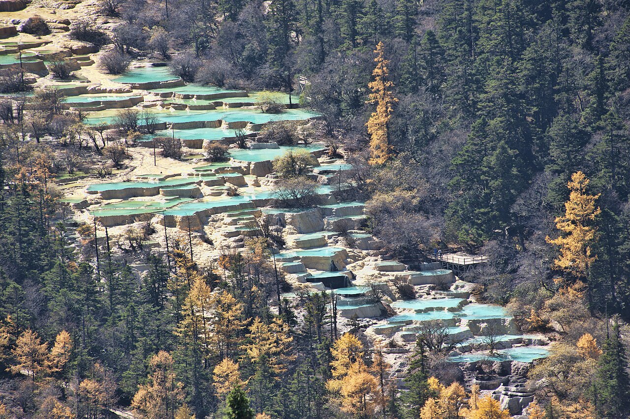
The Huanglong Scenic and Historic Interest Area, inscribed by UNESCO in 1992 as a natural World Heritage Site, is a 7.5-kilometre glacially carved mountain valley in Songpan County, Sichuan Province, at altitudes of 3,180–4,995 metres in the Min Mountains. The site’s 3,400 travertine terraced pools — the largest concentration of travertine formations in China — are produced by one of the world’s highest-calcite-concentration spring systems: groundwater percolating through limestone dissolves calcium carbonate at rate sufficient to deposit the terrace barriers forming the pool cascade. The distinctive gold-yellow colour of the largest pools (the 693-pool Golden Sand Laying on Ground section) and the turquoise of the mid-valley sections are produced by the calcite deposition rate, pool depth, and the specific algal communities that colonise the travertine surfaces.
The Jiuzhaigou-Huanglong corridor and southern Sichuan Jiuzhaigou · Chengdu · Dujiangyan — 56 to 280 km
Fifty-six kilometres northwest of Huanglong by mountain road (approximately 2 hours via Songpan County), the Jiuzhaigou Valley (inscribed 1992) is the other Min Mountain UNESCO natural inscription from the same year, sharing the same geological landscape type — alpine lakes and waterfalls produced by calcium carbonate precipitation in mountain spring systems — but at lower altitude (2,000–3,100 metres versus Huanglong’s 3,180–4,995 metres) and with a broader and more complex lake system (114 separate lakes versus Huanglong’s unified valley terracing). The two inscriptions together document the full altitudinal range of the Min Mountain spring-lake system: Huanglong’s upper valley at the snowline level with its concentrated high-calcite terrace pools, and Jiuzhaigou’s lower valley with its dispersed multi-coloured lake complex. The Jiuzhai-Huanglong Airport (JZH) at 3,448 metres altitude between the two inscriptions serves direct flights from eight Chinese cities, making the two sites a practical single itinerary using the same air gateway. Most visitors combine both inscriptions on a 3–4 day circuit from the airport: one day at Huanglong (the valley walk is 5–6 kilometres with 600 metres of altitude gain to the Huanglong Front Temple), two days at Jiuzhaigou.
Two hundred eighty kilometres south of Huanglong by road (approximately 4.5 hours via the Chengdu-Jiuzhaigou Expressway to Chengdu, then 30 minutes west), the Mount Qingcheng and the Dujiangyan Irrigation System (inscribed 2000) represents the same Min River geography at its lowland terminus. The Min River rises in the Min Mountains 200 kilometres north of Huanglong (the Minjiang headwaters at Min Mountain’s northern slopes) and flows through Songpan County past the Huanglong valley entrance before descending through the Chengdu Plain to the Sichuan Basin. The Dujiangyan irrigation system at the Min River’s exit from the mountains (built 256 BCE) diverts the same river that Huanglong’s calcareous springs feed into the largest irrigated agricultural system in China without modern intervention. Mount Qingcheng (1,260 metres), the sacred Taoist mountain southwest of Dujiangyan, has temple complexes from the Eastern Han period and is one of the Four Sacred Taoist Mountains of China — the ritual landscape that the same population who built Dujiangyan’s engineering system used for mountain pilgrimage in the Han and Tang dynasties.
Three hundred twenty kilometres south of Huanglong by road to Chengdu, then 1.5 hours by HSR, the Mount Emei Scenic Area and the Leshan Giant Buddha (inscribed 1996) document Sichuan’s Buddhist sacred mountain tradition at its southern and most visited pole. Mount Emei (3,099 metres) is the highest of China’s Four Sacred Buddhist Mountains; its temple complex includes the Baoguo Monastery at the mountain’s base (founded Han dynasty, rebuilt Ming dynasty), the Golden Summit (Jinding, 3,077 metres) monastery with its 48-metre gilded statue of Samantabhadra Bodhisattva (Puxian, completed 2006), and 30 temple complexes along the ascent trail requiring 2–3 days to climb. The Leshan Giant Buddha at the Min River confluence (713–803 CE, 71 metres) was carved from the Lingyun cliff face directly opposite the dangerous river currents its sculptor Haitong sought to calm through the merit of the project. The Huanglong-Emei circuit by air (Jiuzhai-Huanglong Airport to Chengdu, then HSR) covers two of the most distinct natural heritage landscapes in China — the alpine terrace lake at 4,000 metres and the Buddhist mountain at 3,099 metres — accessible in adjacent days from Chengdu.
One hundred seventy kilometres south of Huanglong by road (approximately 3 hours via the Chengdu-Jiuzhaigou Expressway to the Wolong access road), the Sichuan Giant Panda Sanctuaries — Wolong, Mt Siguniang, and Jiajin Mountains (inscribed 2006) protect the largest continuous block of wild giant panda habitat remaining. The Wolong component borders the same Qionglai Mountain system that marks Huanglong’s western skyline: looking west from the Huanglong valley entrance on a clear day, the Qionglai Mountains at 4,000–5,000 metres are visible 100 kilometres distant, and they contain the Wolong panda sanctuary’s northeastern margin. The geological connection is direct: the Min Mountains (Huanglong’s location) and the Qionglai Mountains (Wolong’s location) are the two primary mountain ranges of Sichuan’s western highland, both part of the Hengduan Mountain system’s eastern margin, both with glacial lake systems and limestone karst features of the same Mesozoic limestone formation that produces Huanglong’s calcite springs.
Connections northward and to western China Wudang Mountains · Three Parallel Rivers · Potala Palace — 700 to 1,500 km
Seven hundred kilometres east of Huanglong by air (Jiuzhai-Huanglong Airport to Chengdu, then Chengdu to Wuhan, approximately 1.5 hours, then bus to Wudang Mountain, approximately 2 hours), the Ancient Building Complex in the Wudang Mountains (inscribed 1994) in Hubei Province documents Daoist sacred mountain architecture at the opposite end of the same highland landscape zone. The Daoist religious tradition that produced the Wudang temple complex is the same tradition that named Huanglong for the yellow dragon deity (Huanglong = Yellow Dragon) and established the Huanglong Front Temple (Huanglonggou Xisi, a multi-temple complex at the valley’s upper end, dating from the Tang dynasty and rebuilt in the Ming and Qing periods) as a site of pilgrimage for travellers from the Chengdu lowlands. The Huanglong Front Temple complex — including the Huanglong Zhongsi (Middle Temple) at 3,535 metres, the Huanglonghouai (Rear Temple, 3,580 metres), and the scattered hermit cells used by Daoist monks who came to the high valley for retreat — predates the UNESCO inscription by at least 1,000 years and represents the human occupation of the high Min Mountain landscape long before the modern park designation.
One thousand kilometres south of Huanglong by air (via Chengdu and Kunming), the Three Parallel Rivers of Yunnan Protected Areas (inscribed 2003) covers the Hengduan Mountain system’s core zone where the Salween, Mekong, and Yangtze rivers cut their deepest gorges. Huanglong sits at the northeastern corner of the same Hengduan system whose southwestern apex is documented in the Three Parallel Rivers inscription: the Min Mountains are the Hengduan range’s easternmost expression, while the Three Parallel Rivers gorges are its western interior. The altitude gradient between the two inscriptions (Huanglong’s Xuebao Ding peak at 5,588 metres on the inscription’s northwest boundary, and Meili Snow Mountain at 6,740 metres in the Three Parallel Rivers area) marks the vertical extent of the same mountain system. The calcite spring system that produces Huanglong’s travertine pools derives from the same Triassic-Jurassic limestone formation that underlies the Hengduan system across its full extent from Songpan County to the Yunnan gorges.
One thousand two hundred kilometres northwest of Huanglong by air (via Jiuzhai-Huanglong Airport, then connecting to Xining or Lanzhou), the Kaiping Diaolou and Villages (inscribed 2007) is not geographically proximate but illustrates a contrasting Chinese landscape type: the watchtower villages of Guangdong Province built by overseas Chinese returning from Southeast Asia and the Americas in the 19th and 20th centuries. More directly relevant to Huanglong’s cultural-geological context: the nearby (non-UNESCO) Songpan Ancient Town, 100 kilometres south of Huanglong, is one of the best-preserved Ming garrison towns in western China, with intact city walls (1394 CE), a 20-metre stone archway, and an ethnically mixed population of Han, Tibetan, and Hui communities that the Songpan garrison was established to oversee on the Silk Road’s Sichuan-Tibet branch.
Eight hundred kilometres east of Huanglong by air (via Chengdu and then the Chengdu-Kunming HSR to Hunan), the Wulingyuan Scenic and Historic Interest Area (inscribed 1992) in Hunan Province documents the quartzite sandstone pillar landscape of central China, visually opposite to Huanglong’s mountain terrace landscape. Both Huanglong and Wulingyuan were inscribed in 1992 as part of China’s first coordinated UNESCO natural heritage nomination campaign; both document geological processes (carbonate travertine deposition at Huanglong, differential erosion of quartzite-sandstone at Wulingyuan) that produce landscapes with no direct international parallel. From Chengdu, Wulingyuan/Zhangjiajie is reached by high-speed rail (approximately 5 hours to Zhangjiajie West Station via Changsha).
Practical information
Huanglong Scenic Area is accessed from the Jiuzhai-Huanglong Airport (JZH) at 3,448 metres altitude (direct flights from Chengdu, approximately 35 minutes; Beijing, approximately 2.5 hours; Shanghai, approximately 3 hours; Kunming, approximately 1.5 hours) with shuttle bus transfer to the Huanglong park entrance (approximately 1.5 hours, 90 km). Alternatively, from Chengdu by road (approximately 6 hours via Chengdu-Jiuzhaigou Expressway, 320 km) or from Jiuzhaigou Valley by road (approximately 2 hours, 56 km). The Huanglong valley scenic route is 5.6 kilometres long, requiring a round-trip walk of approximately 11 kilometres with 620 metres of elevation gain from the park entrance to the Huanglong Rear Temple at 3,580 metres; allow 4–6 hours. A cableway (Huanglong Ropeway) ascends to 3,745 metres, 400 metres below the rear temple, reducing the altitude gain to approximately 200 metres from the cableway upper station. The high altitude of the walk (3,180–3,580 metres) means altitude sickness is common; allow a day at lower altitude in Jiuzhaigou or Songpan before walking the Huanglong valley. The best visiting season is April–June (the snowmelt season when water flow is highest and the spring vegetation contrasts with the blue pools) and September–October (autumn colour against the travertine). The pools are covered by a light snow layer from November to March, which reduces their colour but creates a distinctive winter landscape. Daily visitor numbers at Huanglong are capped at 12,000; advance booking via the official Huanglong Management Bureau website is required during peak season.
Frequently Asked Questions
Why are Huanglong’s pools a different colour from Jiuzhaigou’s lakes?
Huanglong’s terraced pools and Jiuzhaigou’s lakes are both coloured by calcium carbonate chemistry, but the specific colour range differs because the two systems have different calcite concentration levels and different pool architectures. Huanglong’s springs have a calcite saturation approximately twice that of Jiuzhaigou’s, meaning calcite deposits more rapidly on the pool floors and terrace barriers: the dense, pale yellow-gold calcite crust on Huanglong’s pool floors (typically 2–10 centimetres thick, with the “Golden Sand Laying on Ground” section showing the thickest deposits) reflects sunlight through the water column in a warm-gold spectrum rather than the cold-turquoise spectrum of Jiuzhaigou’s deeper, clearer lakes. The colour also varies within the Huanglong system by section: the upper pools (near the Rear Temple, in the area called Jize Pond) appear deeper blue because they are fed by cleaner snowmelt with lower initial calcite concentration before the spring water has absorbed the full mineral load; the middle section (the 693-pool terrace cascade) shows the characteristic gold-yellow at its peak; the lower section (near the Front Temple) shows the palest, most whitish pools as the calcite concentration drops after deposition upstream. Within any individual pool at any location, colour also shifts with the season: in spring (April–May), snowmelt dilutes the calcite concentration and the pools shift toward clearer blue; in late summer (August–September) when the spring discharge is lowest and calcite concentration is highest, the gold colour is most intense. The two inscriptions together document the full spectrum of calcium carbonate lake colouration in the same mountain system.
What are the Huanglong Front Temple and Rear Temple and why are they here?
The Huanglong temple complex comprises five separate temple structures distributed along the 7.5-kilometre valley, the largest of which are the Huanglong Front Temple (Huanglongqian Si, at 3,176 metres near the valley entrance) and the Huanglong Rear Temple (Huanglonghou Si, at 3,580 metres at the valley’s upper end). The temples were established as Daoist pilgrimage sites in the Tang period (618–907 CE), according to local tradition by the same pilgrimage route that connected the Songpan lowland to the sacred mountain of Xuebao Ding; the Front Temple’s founding is attributed to the early Tang. Both temples were destroyed and rebuilt multiple times through the Ming and Qing dynasties; the current structures date primarily from the Ming (1368–1644) period with Qing reconstruction. The Front Temple is the ceremonial focus of the annual Huanglong Temple Fair (Huanglongsi Miaohui), held on the 15th and 16th days of the sixth lunar month (approximately July–August) and traditionally drawing tens of thousands of pilgrims from Songpan, Ngawa, and the Chengdu lowlands; the fair is a multi-ethnic gathering of Han, Tibetan, Qiang, and Hui communities who maintain separate ritual practices at the same site. The Rear Temple, at the valley’s upper end, is the architectural centrepiece of the UNESCO inscription: its three-bay wooden structure (rebuilt 1980) houses a golden Huanglong image and overlooks the Jize Pond (Juansheng Fen and Jin Chi sections), the most concentrated travertine pool area in the valley. The pilgrimage function of the site predates the scientific understanding of travertine chemistry by approximately 1,200 years: the monks and pilgrims who climbed to the Rear Temple understood the coloured pools as a manifestation of the yellow dragon deity’s presence, rather than as a geochemical landscape — an interpretation that the UNESCO natural inscription does not displace but supplements.
How is Huanglong’s travertine landscape formed and why is it at risk?
Huanglong’s travertine pools are formed by a process called speleothem precipitation in an open-air setting: groundwater percolating through the thick Triassic limestone of the Min Mountains dissolves calcium carbonate (CaCO₃) as it passes through the rock, emerging as a spring-fed stream at Huanglong’s valley head with a calcite concentration of approximately 300 mg per litre (roughly three times the calcite saturation of a typical carbonate aquifer). As the water flows down the valley slope and loses carbon dioxide to the atmosphere (a process accelerated by turbulence, algal photosynthesis, and the open air), the calcite saturation exceeds the precipitation threshold and calcium carbonate crystallises on the streambed, gradually building up the low dam walls (rims) of the pool terraces over centuries. The process is self-reinforcing: once a rim begins forming, water is ponded above it, creating the conditions (deeper, quieter water with less turbulence) that accelerate deposition and raise the rim further. The risk to the landscape comes primarily from groundwater drawdown: if upstream land use (logging, road construction, or residential development) changes the infiltration patterns of the catchment above the Huanglong springs, the calcite-laden water supply to the valley decreases. Additionally, human foot traffic on the travertine (historically managed by wooden boardwalks) deposits organic matter that promotes microbial growth incompatible with calcite deposition, potentially degrading the pool floors. A 2005 monitoring study by the Sichuan University noted that 23 of the 3,400 pools had shown deterioration in colour and travertine integrity attributable to visitor impact; the current boardwalk and visitor flow system was redesigned in response. Climate change is a longer-term risk: warmer temperatures reduce the snowpack feeding the Min Mountain springs, potentially reducing the spring discharge volume and shifting the calcite-precipitation balance.
Sources
- S1 — UNESCO World Heritage Centre — Huanglong Scenic and Historic Interest Area (Ref. 638) — https://web.archive.org/web/20230601000000/https://whc.unesco.org/en/list/638/
- S2 — UNESCO World Heritage Centre — Statement of Outstanding Universal Value (Ref. 638) — https://whc.unesco.org/en/list/638/
Spotted an error? Write to editorial@culturalheritageonline.com and we correct it the same day.