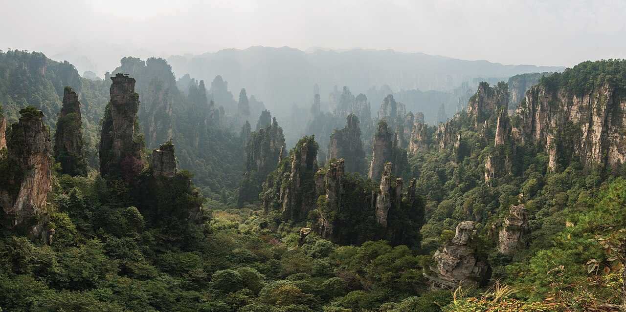
The Wulingyuan Scenic and Historic Interest Area, inscribed by UNESCO in 1992 as a natural World Heritage Site, is a 264-square-kilometre landscape of 3,103 quartzite-sandstone pillars and peaks in northwestern Hunan Province’s Zhangjiajie area, with the tallest pillars reaching 400 metres above the valley floors. The pillars were formed over 300 million years from Devonian-period quartzite sandstone deposits that erosion has carved into isolated columns by preferentially dissolving the softer inter-pillar material, leaving the harder quartzite standing as vertical formations above gorges cut by the Suoxi and Luo rivers. The inscription encompasses four major scenic areas — Zhangjiajie National Forest Park (designated 1982, China’s first national forest park), Suoxiyu Nature Reserve, Tianzishan Nature Reserve, and the Yangjiajie Scenic Area — connected by a network of walkways, cable cars, and the Bailong Elevator (the world’s tallest outdoor lift at 326 metres, built in 2002 into the cliff face).
Central China and the Yangtze highlands Wudang Mountains · Sanqingshan · Fenghuang — 350 to 650 km
Three hundred fifty kilometres northwest of Wulingyuan by road (approximately 4.5 hours via the Zhangjiajie-Wuhan Expressway to the Wudang Mountain interchange), the Ancient Building Complex in the Wudang Mountains (inscribed 1994) in Hubei Province is the nearest UNESCO World Heritage Site to the northwest. The Wudang complex — 33 architectural groups built across the nine main peaks of the Wudang Mountains from the Tang period through the early Qing — occupies the same Yangtze highland zone as Wulingyuan but in a different geological substrate: where Wulingyuan’s pillars are Devonian quartzite sandstone shaped by river erosion, the Wudang Mountains are Proterozoic metamorphic rock of the Qinling-Dabie system, with a more massive, rounded mountain form. The visual contrast between the two inscriptions is representative of the two dominant mountain landscape types of central China’s highland zone: the eroded sandstone pillars of the Yangtze tributaries (Wulingyuan, and further west the South China Karst limestone towers) versus the metamorphic massifs of the Qinling-Huai divide. From Zhangjiajie Airport, the Wudang Mountains are reached by road via Zhangjiajie to the G5513 Expressway (approximately 4.5 hours).
Six hundred fifty kilometres east of Wulingyuan by road via Nanchang or 5 hours by high-speed rail (Zhangjiajie West to Nanchang to Shangrao), the Mount Sanqingshan National Park (inscribed 2008) in Jiangxi Province documents the same quartzite-granite pillar landscape as Wulingyuan but in a different rock type and at higher altitude. Sanqingshan’s 2,158-metre summit rises above subtropical forest in Shangrao Prefecture; its 2,200 granite pillars (the highest, the “Eastern Huamaster” column, is 128 metres tall) share the vertical landscape character of Wulingyuan’s sandstone pillars but are carved by different erosion processes (mechanical weathering of jointed granite versus differential dissolution of interbedded quartzite and softer strata at Wulingyuan). Both inscriptions document the same visual grammar — isolated vertical formations above forested gorges — in the same geological era of China’s highland landscape. The Sanqingshan cable car system ascends from 250 metres to 1,530 metres; the high-altitude boardwalk traverses the pillar zone at cloud level in a way visually similar to Wulingyuan’s Tianmenshan Cableway.
Sixty kilometres southwest of Wulingyuan by road (approximately 1 hour from the Zhangjiajie scenic area), the ancient town of Fenghuang (Phoenix Ancient Town) is not a UNESCO World Heritage Site but provides the strongest cultural complement to Wulingyuan’s natural landscape in the immediate area. Fenghuang is a Miao minority ethnic community town on the Tuojiang River in Hunan’s western highland, with a preserved vernacular urban fabric of wooden stilted houses (diaojiaolou) built over the river and along the stone-paved lanes of the old town, largely intact from the Qing period with significant Ming foundations. The Miao cultural tradition of Fenghuang — known for silver jewellery craftsmanship, wax-resist textile dyeing, and the Stilt-House festival — is continuous with the Tujia ethnic minority culture of the Zhangjiajie area (Wulingyuan sits within Tujia and Miao Autonomous Prefecture of western Hunan). Both Fenghuang and Zhangjiajie are accessible from the same Zhangjiajie Hehua International Airport, making the natural inscription and the vernacular townscape a practical combined itinerary for visitors to the region.
Five hundred kilometres east of Wulingyuan by high-speed rail (approximately 4 hours from Zhangjiajie West via Changsha to Nanchang), the Lushan National Park in Jiangxi Province (inscribed 1996) documents China’s earliest culturally documented mountain landscape: Lushan’s summit above Poyang Lake has been the site of Buddhist and Taoist retreats since the Eastern Jin period (4th century CE) and of the White Deer Grotto Academy (Bailudong Shuyuan), the most influential Confucian academy of the Song dynasty, since the 10th century. Where Wulingyuan’s landscape was geologically isolated from Chinese cultural geography until its 1982 designation as a national park (the area’s Tujia and Miao communities knew it as farming and forested land, not as a scenic destination), Lushan has been a continuous pilgrimage and retreat site for 1,600 years. Both inscriptions are in Hunan-Jiangxi highland zone; both are accessible from the Changsha hub by high-speed rail in 3–4 hours.
Connections south and southwest South China Karst · Huangshan · Longmen Grottoes — 600 to 1,000 km
Six hundred kilometres southwest of Wulingyuan by high-speed rail (approximately 4 hours from Zhangjiajie West via Changsha to Guiyang), the South China Karst UNESCO inscription (inscribed 2007, extended 2014) covers eight component sites in Guizhou, Yunnan, Guangxi, and Chongqing documenting the world’s most extensive subtropical karst landscape. The visual connection between Wulingyuan’s quartzite-sandstone pillars and the South China Karst’s limestone towers (fenglin) is the most discussed geological-aesthetic parallel in Chinese landscape science: both produce the visual grammar of vertical isolated formations above valley floors, but by different geological mechanisms (erosion of interbedded sandstone at Wulingyuan; dissolution of limestone by slightly acidic groundwater at South China Karst). The Guilin-Yangshuo fenglin (conical limestone towers along the Li River), the most photographed of the South China Karst components, produces the vertical stone-above-water landscape that Chinese painting has depicted for 2,000 years; Wulingyuan’s quartzite pillars are the sandstone geological equivalent. Both inscriptions are in the same province cluster of the Yangtze highlands; the high-speed rail connection from Changsha to Guiyang (approximately 3.5 hours) makes the two inscriptions accessible in a continuous southwest China itinerary.
Eight hundred kilometres east of Wulingyuan by high-speed rail (approximately 5 hours from Zhangjiajie West via Changsha and Nanchang to Hangzhou), the West Lake Cultural Landscape of Hangzhou (inscribed 2011) and the Classical Gardens of Suzhou (inscribed 1997, extended 2000) document the Chinese literati aesthetic at its most refined urban expression — the counterpart to Wulingyuan’s raw geological landscape. The aesthetics of the Wulingyuan pillar landscape and of the Suzhou scholar garden share a conceptual ancestry: both idealise the vertical stone form (the quartzite pillar rising 400 metres at Wulingyuan; the taihu rock scholar’s stone in the garden pond) as the visual embodiment of mountain verticality. Chinese garden scholars from the Ming period (the golden age of Suzhou garden construction) explicitly describe the selection of taihu limestone rocks from Lake Tai as the compression of a mountain landscape into a garden space — an aesthetic principle directly related to the vertical pillar landscape that Wulingyuan documents at full geological scale. From Zhangjiajie, Hangzhou is reached by high-speed rail (approximately 5 hours via Changsha and Nanchang).
Nine hundred kilometres northeast of Wulingyuan by high-speed rail (approximately 6 hours from Zhangjiajie West via Changsha and Wuhan to Huangshan North), the Huangshan (Yellow Mountain) inscription (inscribed 1990) in Anhui Province documents the granite pinnacle landscape that became China’s defining landscape painting subject in the 17th century. The visual parallel between Wulingyuan’s quartzite sandstone pillars and Huangshan’s granite peaks is the most direct geological echo across two separate inscriptions: both present an above-cloud vertical landscape of isolated stone above forest, the dominant landscape type of China’s eastern mountain zone. The 17th-century Huangshan painters (Hongren, Shitao) who made the granite pinnacle the symbol of Chinese landscape art were working in the same aesthetic tradition that later produced the “floating mountain” imagery associated with Wulingyuan’s pillars. The connection between the two inscriptions as aesthetic objects is as strong as their geological distinction (granite versus quartzite; southwestern Anhui versus northwestern Hunan).
One thousand kilometres north of Wulingyuan by high-speed rail (approximately 6 hours from Zhangjiajie West via Changsha and Wuhan to Xi’an), the Mausoleum of the First Qin Emperor and Terracotta Army (inscribed 1987) represents the human cultural pole of the Chinese landscape: where Wulingyuan documents the natural geology of China’s highland interior, the Terracotta Army documents the most concentrated expression of Han Chinese state power and funerary culture. The contrast between the two inscriptions is geographic and temporal: Wulingyuan’s quartzite pillars began forming in the Devonian period (approximately 380 million years ago) and the landscape’s human significance is recent (the Tujia and Miao communities of western Hunan farmed the valley floors below the pillars; the pillars themselves were not culturally significant until the 1982 forest park designation); the Terracotta Army represents a single specific human act (the First Emperor’s burial programme, 246–210 BCE) executed at an enormous scale in the lowland environment opposite to Wulingyuan’s highland remoteness.
Practical information
Wulingyuan Scenic Area is accessed from Zhangjiajie Hehua International Airport (DYG), which has direct flights from Beijing (approximately 2 hours), Shanghai (approximately 2 hours), Guangzhou (approximately 1.5 hours), and Chengdu (approximately 1.5 hours). Alternatively, high-speed rail to Zhangjiajie West Station (on the Zhangjiajie-Jishou HSR) from Changsha South (approximately 2 hours), connecting to Wuhan (approximately 4 hours) and Beijing West (approximately 7 hours). From Zhangjiajie city to the Wulingyuan park entrance is approximately 32 kilometres by road (40 minutes). The scenic area’s four main components — Zhangjiajie National Forest Park (the primary pillar area), Suoxiyu (including the Golden Whip Stream canyon), Tianzishan (the highest point, accessible by cable car from the Suoxiyu side), and Yangjiajie (including the “Avatar Hallelujah Mountain” pillar) — require at least 3 days to cover at walking pace. Key transport within the park: the Tianmenshan Cableway (the world’s longest passenger cable car at 7.5 kilometres, ascending to the 1,518-metre Tianmen Mountain with its 999-step staircase and the “Heaven’s Gate” natural arch, 131 metres high and 37 metres wide in the cliff face); the Bailong Elevator (cliff elevator, 326 metres); and park shuttle buses. The Avatar connection: the production team of James Cameron’s 2009 film visited Zhangjiajie in 2008 and renamed the “Southern Sky One Column” pillar (Nantian Yizhu) the “Avatar Hallelujah Mountain” in the film’s production notes; the Chinese park management officially renamed the pillar in 2010 following the film’s release, a decision that has since become a significant factor in the park’s international marketing. Daily visitor numbers at Wulingyuan exceed 50,000 in peak season (May–October); booking accommodation in Wulingyuan town in advance is essential.
Frequently Asked Questions
How were Wulingyuan’s quartzite sandstone pillars formed?
Wulingyuan’s 3,103 quartzite-sandstone pillars were formed over approximately 300 million years by a sequence of geological processes beginning in the Devonian period (approximately 380–360 million years ago) when the region was a shallow coastal sea. Thick layers of quartz sand accumulated on the seafloor, gradually compacted and cemented into quartzite-sandstone by the weight of overlying sediment and the circulation of silica-rich groundwater; the resulting rock is exceptionally hard (Mohs scale 7–8 in the quartzite layers, 5–6 in the softer sandstone interbeds). The geological uplift that occurred as the Yangtze Plateau rose during the Mesozoic and Cenozoic eras (approximately 100–10 million years ago) elevated this layered rock above sea level, exposing it to weathering. The critical factor producing the pillar landscape rather than a plateau or mesa: the vertical jointing (fracture planes in the rock caused by the same tectonic stresses that uplifted the plateau) created a grid-like pattern of weaknesses that water, ice, and plant roots preferentially eroded. As erosion removed material along the joint planes, the harder quartzite blocks between the joints were left standing as isolated pillars; the material between the pillars (the softer sandstone and the joint infill) was more rapidly removed by the Suoxi and Luo rivers and their tributaries. The vertical faces of the pillars are kept nearly plumb by the same jointing: where a pillar’s surface weathers unevenly, the overhanging section eventually fails and falls, maintaining the near-vertical profile. The current pillar height (up to 400 metres) represents the difference between the original plateau surface and the current valley floor, a difference produced by approximately 10–15 million years of erosion since the Yangtze Plateau’s principal uplift phase.
What is the Avatar connection and how has it affected visitor numbers?
The connection between Wulingyuan’s Zhangjiajie National Forest Park and the 2009 James Cameron film Avatar relates to the visual design of the film’s fictional Pandora landscape, specifically the floating “Hallelujah Mountains” — which the film’s production designers, led by Robert Stromberg and Yuri Bartoli, have described as inspired in part by a photograph of the “Southern Sky One Column” pillar at Zhangjiajie. Cameron’s team visited Zhangjiajie in 2008 during pre-production; the production’s own accounts describe the Zhangjiajie landscape as one of several inspirations (along with karst formations in Thailand and Amazon jungle imagery) for the Pandora landscape. The Chinese park management in 2010 renamed the “Southern Sky One Column” (Nantian Yizhu) to “Avatar Hallelujah Mountain” (Hallelujah Shan) following a petition to the local government after the film’s release. The marketing effect has been significant: annual visitor numbers to the Wulingyuan scenic area grew from approximately 2 million pre-Avatar to approximately 36 million in 2019 (before the COVID-19 pandemic), making it one of China’s ten most visited tourist destinations. The UNESCO inscription itself (1992) predates the Avatar connection by 17 years and generated limited international recognition; the film produced a wave of international awareness that has since become the primary frame through which the park is marketed abroad, despite the UNESCO inscription’s status as the formal international heritage designation. The park management’s 2022 “Zhangjiajie International Forest Conservation” framework attempts to rebalance the Avatar-tourism framing with the conservation message of the UNESCO inscription, including strict daily visitor limits for the Hallelujah Mountain zone specifically.
What are the Tujia and Miao cultural traditions of the Wulingyuan area?
Wulingyuan lies within the Zhangjiajie City administrative area of Hunan Province, which is part of the Xiangxi Tujia and Miao Autonomous Prefecture — one of China’s ethnic minority autonomous regions, established in 1957. The Tujia people (approximately 8 million total population nationwide, concentrated in the Wuling mountain area of Hunan and Chongqing) are the majority ethnic community of the Zhangjiajie area; the Miao (Hmong) are the second largest community in western Hunan. The Tujia traditional cultural practices documented in the Zhangjiajie area include: the Maogusi dance (a ritual dance performed by male performers wearing grass costumes, documented in literary sources from the Song dynasty and considered one of the oldest surviving Chinese performing art forms); the Tujia brocade textile tradition (Xilankapu, the hand-woven patterned cloth using a distinctive back-strap loom with geometric patterns representing animals, plants, and cosmological symbols, currently maintained in a small number of village households); and the local Tujia architectural tradition of stilted wooden houses (diaojiaolou, the same tradition more famous in Fenghuang’s Miao version) built on the slopes above the valley floors. The Tujia communities who lived in the area before the park designation used the lower valley floors for rice farming and the forest for hunting and timber; the park management has displaced most agricultural use within the scenic area boundaries, with Tujia families remaining primarily in the villages outside the park entrance and in Wulingyuan town itself. The UNESCO inscription made no reference to the Tujia cultural dimension of the landscape — the inscription criteria are exclusively natural — but the Tujia and Miao cultural presence in the area is documented in the Zhangjiajie Ethnographic Museum in the city centre and in several village cultural centres in the park’s surroundings.
Sources
- S1 — UNESCO World Heritage Centre — Wulingyuan Scenic and Historic Interest Area (Ref. 640) — https://web.archive.org/web/20230601000000/https://whc.unesco.org/en/list/640/
- S2 — UNESCO World Heritage Centre — Statement of Outstanding Universal Value (Ref. 640) — https://whc.unesco.org/en/list/640/
Spotted an error? Write to editorial@culturalheritageonline.com and we correct it the same day.