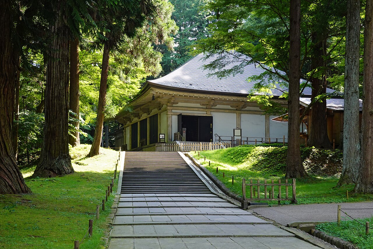
Hiraizumi — Temples, Gardens and Archaeological Sites Representing the Buddhist Pure Land, inscribed by UNESCO in 2011, preserves the remnants of the 12th-century capital of the Fujiwara of the North (Oshu Fujiwara) — the only political entity that rivalled the Kyoto imperial court during the Heian period. At its 12th-century peak, Hiraizumi held a population of approximately 100,000 and was described by the Chinese traveller Xu Jing as the equal of the Heian capital. The Konjikido (Golden Hall) of Chusonji is the only surviving intact Fujiwara-period structure: entirely gilded inside and out, it houses the mummified remains of four Oshu Fujiwara lords beneath the altar.
The Tohoku corridor north and south Iwate · Aomori · Hokkaido · Nikko — 80 to 600 km
Eighty kilometres south of Hiraizumi in Kamaishi City, Iwate Prefecture, one component of the Sites of Japan’s Meiji Industrial Revolution is the closest UNESCO site to Hiraizumi in any direction. The Kamaishi Iron Mine, part of the 23-component inscription spread across Japan, was one of the first iron ore mines developed using Western technology in Japan — the Hashino Ironworks at Kamaishi, operating from 1858, used reverberatory furnace technology adapted from Dutch manuals to produce iron for the early Meiji industrial programme. The same domain administrators who managed the Hiraizumi heritage sites in the post-Fujiwara period oversaw the transition to iron production in the Kamaishi mountains in the 19th century — the iron ore deposits in the Kamaishi range had been identified by domain geological surveys in the early Edo period. From Hiraizumi, Kamaishi is reached by JR Tohoku Main Line south to Shin-Hanamaki and JR Kamaishi Line east (approximately 2 hours). The Kamaishi component of the inscription is the only UNESCO Meiji Industrial site directly accessible from a Tohoku base, making Hiraizumi a natural anchor for a northeast Japan Meiji industrial heritage itinerary.
One hundred fifty kilometres north of Hiraizumi by Tohoku Shinkansen to Shin-Aomori and local connections, the Jomon Prehistoric Sites in Northern Japan form the nearest natural UNESCO heritage to Hiraizumi in the northern Tohoku corridor. The 17 component sites, inscribed in 2021, document the Jomon culture — Japan’s hunter-gatherer tradition with the world’s oldest known pottery — across a 10,000-year span. The Sannai Maruyama site in Aomori City, the best-known component, documents a village occupied for approximately 1,700 years (3900–2300 BCE) with a population estimated at 500 at its peak; the postholes of a six-pillared structure approximately 15 metres high have been excavated and the structure reconstructed for visitor interpretation. Hiraizumi’s 12th-century Buddhism and the Jomon sites’ prehistoric settlements together represent the two poles of northern Japan’s documented human presence — 10,000 years of occupation on the same landscape, the Jomon sites documenting the pre-agricultural and the Hiraizumi sites documenting the Buddhist-state phases of that occupancy. From Hiraizumi, Sannai Maruyama is reached by Tohoku Shinkansen to Shin-Aomori (approximately 70 minutes) and city bus from Aomori Station (20 minutes).
Two hundred kilometres northwest of Hiraizumi via bus to Ichinoseki and JR to Akita and Higashi-Noshiro, the Shirakami-Sanchi natural site in the mountains of Aomori and Akita Prefectures protects 169,700 hectares of virgin temperate beech forest — the largest surviving stand of primeval beech in East Asia, inscribed in 1993. The forest has no access roads or facilities within its core zone; the Tsugaru Shirakami hiking route on the western slopes is the primary access, requiring a full day between refuge huts. Shirakami-Sanchi is notable for being inscribed in 1993 alongside Horyu-ji and Himeji as Japan’s very first UNESCO cycle — its designation before any management framework for Japanese natural sites existed established the institutional precedents that all subsequent Japanese natural UNESCO nominations followed. From Hiraizumi, the forest’s trailheads in Akita are reached by JR Tohoku Shinkansen to Akita (approximately 90 minutes) and JR Gono Line local service west toward the Shirakami mountains.
Three hundred fifty kilometres south of Hiraizumi by Tohoku Shinkansen to Utsunomiya and local connection (approximately 90 minutes total), the Shrines and Temples of Nikko in Tochigi Prefecture represent the decorative extreme of the same Tokugawa political tradition that ultimately destroyed the Oshu Fujiwara in 1189. Tokugawa Ieyasu, enshrined at Toshogu in 1617, was the founder of the shogunate whose 250-year predecessor Minamoto no Yoritomo had ended the Fujiwara dynasty’s independent rule. The 2.5 million sheets of gold leaf applied to the Toshogu complex and the 508 relief carvings of the Yomeimon Gate represent the shogunal aesthetic of maximum ornament at imperial scale; the surviving Konjikido at Hiraizumi, the last fragment of the Fujiwara capital, applies the same gold-leaf technique to a single small hall as the statement of a regional power that ruled without shogunal validation. The two sites illuminate, by contrast, both the ambition and the fragility of political power in medieval Japan.
Connections to Hokkaido and beyond Sado Island · Hokkaido — 300 to 600 km
Three hundred kilometres southwest of Hiraizumi by Tohoku Shinkansen to Sendai and connecting train/ferry, the Sado Island Gold Mine in Niigata Prefecture (inscribed in 2024) is Japan’s most recent UNESCO addition and the closest sea-route heritage destination to Hiraizumi’s Tohoku base. The mine on Sado Island in the Sea of Japan produced gold from the 17th century through 1989 CE, supplying the Tokugawa mint with the gold for the oban and koban coins that circulated as the shogunate’s highest-denomination currency. The mine’s preserved industrial landscape — tunnels, ore-processing facilities, the mining town of Aikawa with its Edo-period merchant district — represents the Tokugawa economic infrastructure that funded the political stability within which the ruins of the Fujiwara capital at Hiraizumi survived uncleared. From Hiraizumi, Sado is reached by Tohoku Shinkansen to Niigata (approximately 2.5 hours from Ichinoseki) and jet ferry from Niigata to Ryotsu on Sado (1 hour).
Three hundred fifty kilometres north of Hiraizumi by Tohoku Shinkansen to Shin-Hakodate-Hokuto (approximately 90 minutes) and connecting limited express to Abashiri and bus, Shiretoko Peninsula in Hokkaido is one of the world’s remaining wilderness areas where polar pack ice reaches a temperate-latitude coastline. Inscribed in 2005, the 71,100-hectare site encompasses one of the most productive marine ecosystems in the North Pacific: the spring melt of sea ice releases nutrient pulses that feed a food chain from capelin to brown bears, Steller’s sea eagles, and sperm whales. The brown bear population on Shiretoko is the densest in Japan. Shiretoko is more than 8 hours from Hiraizumi by combined rail connections, making it a multi-day extension to any Tohoku itinerary; most visitors fly from Tokyo to Memanbetsu Airport (Hokkaido) and travel by bus to Utoro on the peninsula’s western coast (2 hours).
Four hundred kilometres south of Hiraizumi by Tohoku Shinkansen (approximately 2 hours to Tokyo) and Tobu Nikko Line, the UNESCO sites of the Kanto region offer the most practically accessible extension to a Hiraizumi itinerary. The National Museum of Western Art in Tokyo (Le Corbusier, 1959) is 90 minutes south of Hiraizumi by Shinkansen; the Tomioka Silk Mill in Gunma is 180 minutes south; the Nikko shrines are 90 minutes south with a change at Utsunomiya. For visitors making the Tohoku UNESCO circuit — Hiraizumi, Jomon Sites, Shirakami-Sanchi — the Kanto sites provide a natural southward extension before a return to Tokyo or Kansai on the Tokaido Shinkansen.
Practical information
Hiraizumi is on the JR Tohoku Main Line, served by limited express from Ichinoseki Station (5 minutes) — Ichinoseki is a stop on the Tohoku Shinkansen. From Tokyo, the journey to Ichinoseki by Shinkansen takes approximately 2 hours and 20 minutes; from Sendai, approximately 35 minutes. The UNESCO sites are within walking distance of Hiraizumi Station: Motsuji Temple (10 minutes walk, the most completely preserved 12th-century garden in Japan), Chusonji Temple (20 minutes walk or 5 minutes by bus, including the Konjikido Golden Hall). The Konjikido opens at 8:30 and closes at 17:00 (16:30 November to February). Entry is paid and covers the Golden Hall, the Sutra Repository (Kyozo), and the Konjikido Sankozo museum, which displays the decorative arts removed from the hall for conservation. A full visit to Hiraizumi’s UNESCO sites requires approximately 3 hours. Accommodation in Hiraizumi itself is limited; most visitors base themselves in Ichinoseki or Sendai. Hiraizumi receives approximately 700,000 visitors per year, concentrated in spring cherry-blossom season when the Motsuji garden paths are lined with blossoming trees.
Frequently Asked Questions
Why did the Oshu Fujiwara build their capital at Hiraizumi in remote northern Japan?
The Oshu Fujiwara established Hiraizumi as their capital for reasons that were simultaneously geographic, economic, and political. The site controlled the northern terminus of the Honshu road network and the gateway to the gold-producing mountains of the Kitakami highlands — gold was the primary product that made the Oshu Fujiwara wealthy enough to construct the Konjikido and the Motsuji Paradise Garden. The Fujiwara of the North (Oshu Fujiwara) were distinct from the Kyoto Fujiwara regents, though they shared a clan name; they had governed the northeastern Tohoku region since the late 10th century as regional administrators who gradually accumulated autonomous military power. The Hiraizumi capital was built from approximately 1088 CE under Fujiwara no Kiyohira, who had survived the Earlier Nine-Year War and the Later Three-Year War — military conflicts in which his family was nearly destroyed — and who constructed the Chusonji temple complex as a monument to the war dead of both sides and a statement of Buddhist compassion as political authority. The capital reached its peak under Fujiwara no Hidehira (1122–1187 CE), who expanded it to a Buddhist Pure Land city modelled on Kyoto’s urban plan. Minamoto no Yoritomo, who had established the Kamakura shogunate in 1185, invaded in 1189 and ended Hiraizumi’s independent existence; the buildings were burned or abandoned, and the city’s plan survived only in the earthworks and garden remains that UNESCO inscribed 800 years later.
What is the Motsuji garden and why is it significant for Japanese garden history?
Motsuji Temple’s Jodo Teien (Paradise Garden) is the most completely preserved 12th-century Pure Land garden in Japan — a category of garden design that attempts to reproduce on earth the appearance of Amida Buddha’s Western Paradise (Sukhavati) as described in the Amitabha Sutra. The garden centres on a 100-by-180-metre pond (Oizumi-ga-ike) surrounded by the earthwork foundations of seven hall buildings that stood around its shore during the Fujiwara period; the halls are gone but the garden’s water features, island arrangements, and connecting earthworks survive in 90% of their 12th-century configuration. The garden’s original intent was functional as well as aesthetic: ceremonies (including the annual Ennen bugaku court dance, which continues today on May 4) were performed on the garden bridges and island platforms as part of the temple’s ritual calendar. The contrast between Motsuji’s earthwork foundations — a garden of emptiness and outline — and the intact Konjikido 700 metres away — a building of total gold-leaf enclosure — captures the full range of 12th-century Fujiwara aesthetic production within a single UNESCO inscription. The Motsuji garden is walked on a gravel path around the pond perimeter that takes approximately 30 minutes; the garden’s spring irises (in bloom in mid-June) are particularly remarkable.
How does Hiraizumi connect to the poetry of Matsuo Basho?
Matsuo Basho, the 17th-century haiku master, visited Hiraizumi in 1689 CE during his journey through northern Japan documented in the Oku no Hosomichi (The Narrow Road to the Deep North). At the ruins of the Fujiwara capital, then 500 years overgrown and nearly invisible except for the surviving Chusonji structures, Basho composed the most celebrated poem of his journey and possibly of his career: “Natsugusa ya / tsuwamonodomo ga / yume no ato” — “The summer grasses: / all that remains of the warriors’ / dream.” The poem is inscribed on a stone monument in the Hiraizumi municipal park and is one of the most quoted Japanese poems on the theme of impermanence. Basho’s visit established Hiraizumi as a canonical destination in Japanese literary travel writing; subsequent writers and intellectuals visited the site specifically to follow Basho’s journey and meditate on the same ruins. The Oku no Hosomichi (Narrow Road) itself has been proposed as a UNESCO inscribed route and is designated a national heritage road in Japan; the segment through Hiraizumi and onward to the northern Tohoku is the section most closely tied to Basho’s masterwork. The poem’s meditation on the impermanence of military power and political ambition is entirely congruent with the UNESCO inscription’s documentation of a capital that was built, destroyed, and now survives only in its garden earthworks and a single gilded hall.
Sources
- S1 — UNESCO World Heritage Centre — Hiraizumi – Temples, Gardens and Archaeological Sites Representing the Buddhist Pure Land (Ref. 1277) — https://web.archive.org/web/20230601000000/https://whc.unesco.org/en/list/1277/
- S2 — UNESCO World Heritage Centre — Statement of Outstanding Universal Value (Ref. 1277) — https://whc.unesco.org/en/list/1277/
Spotted an error? Write to editorial@culturalheritageonline.com and we correct it the same day.