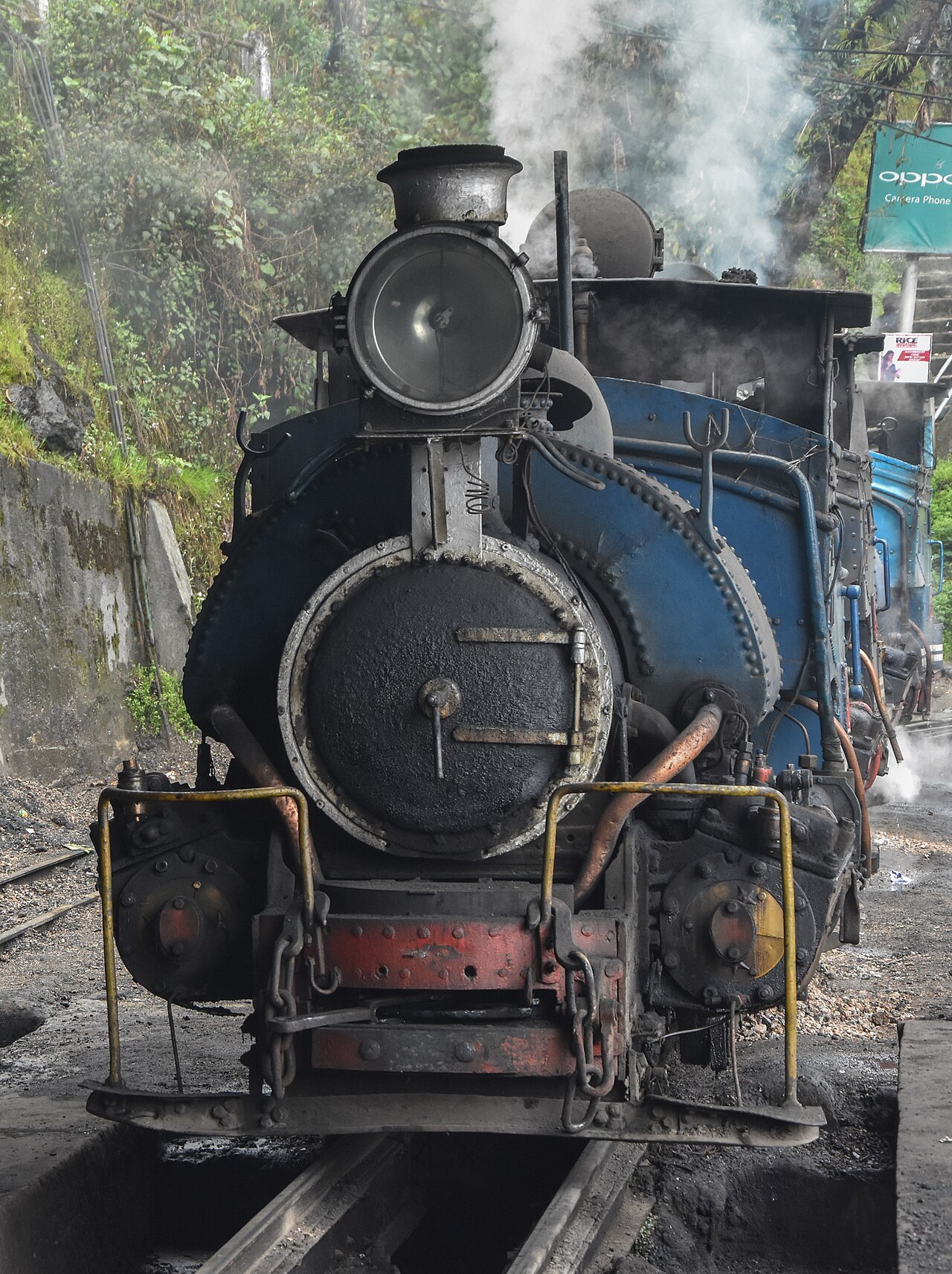
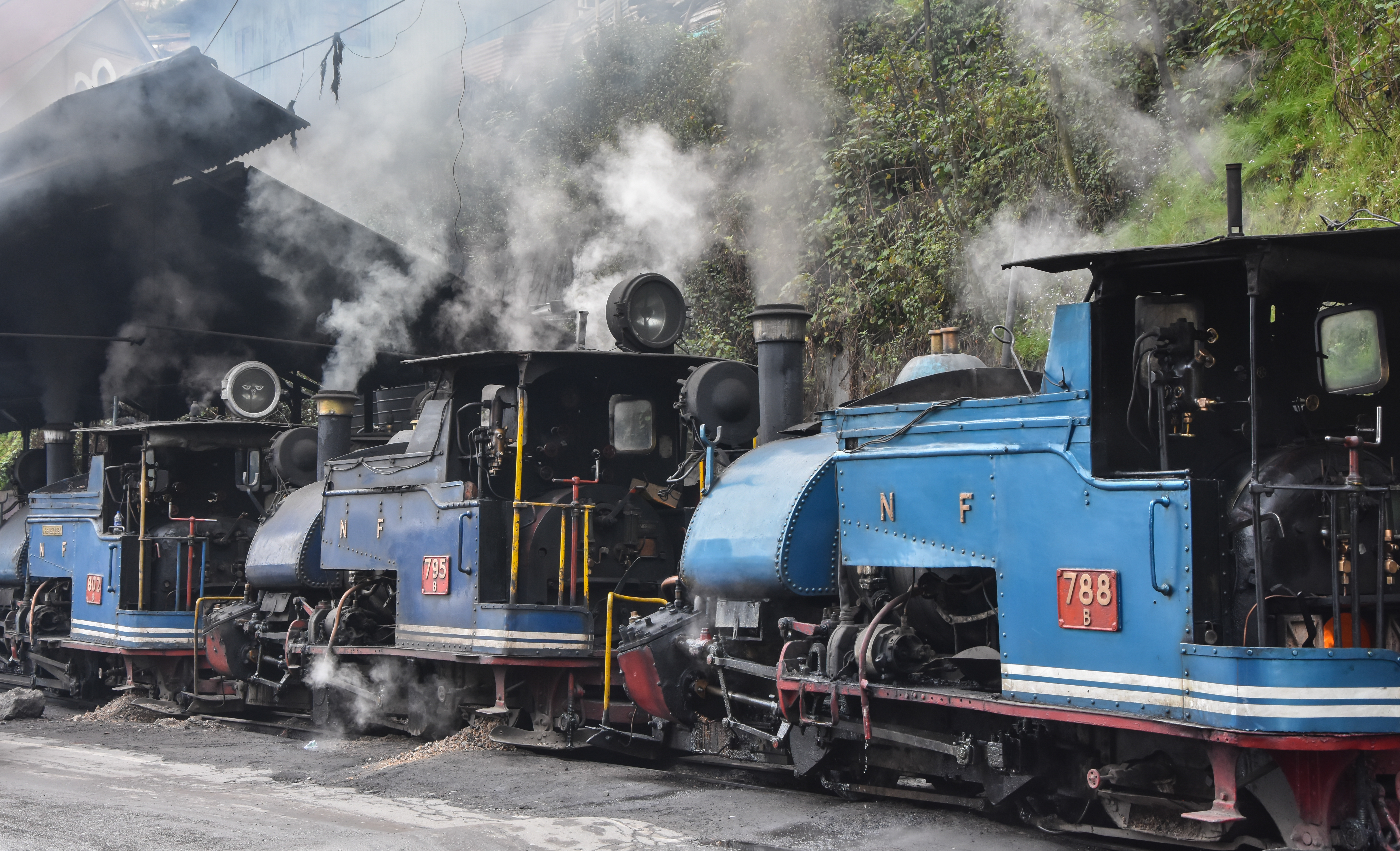
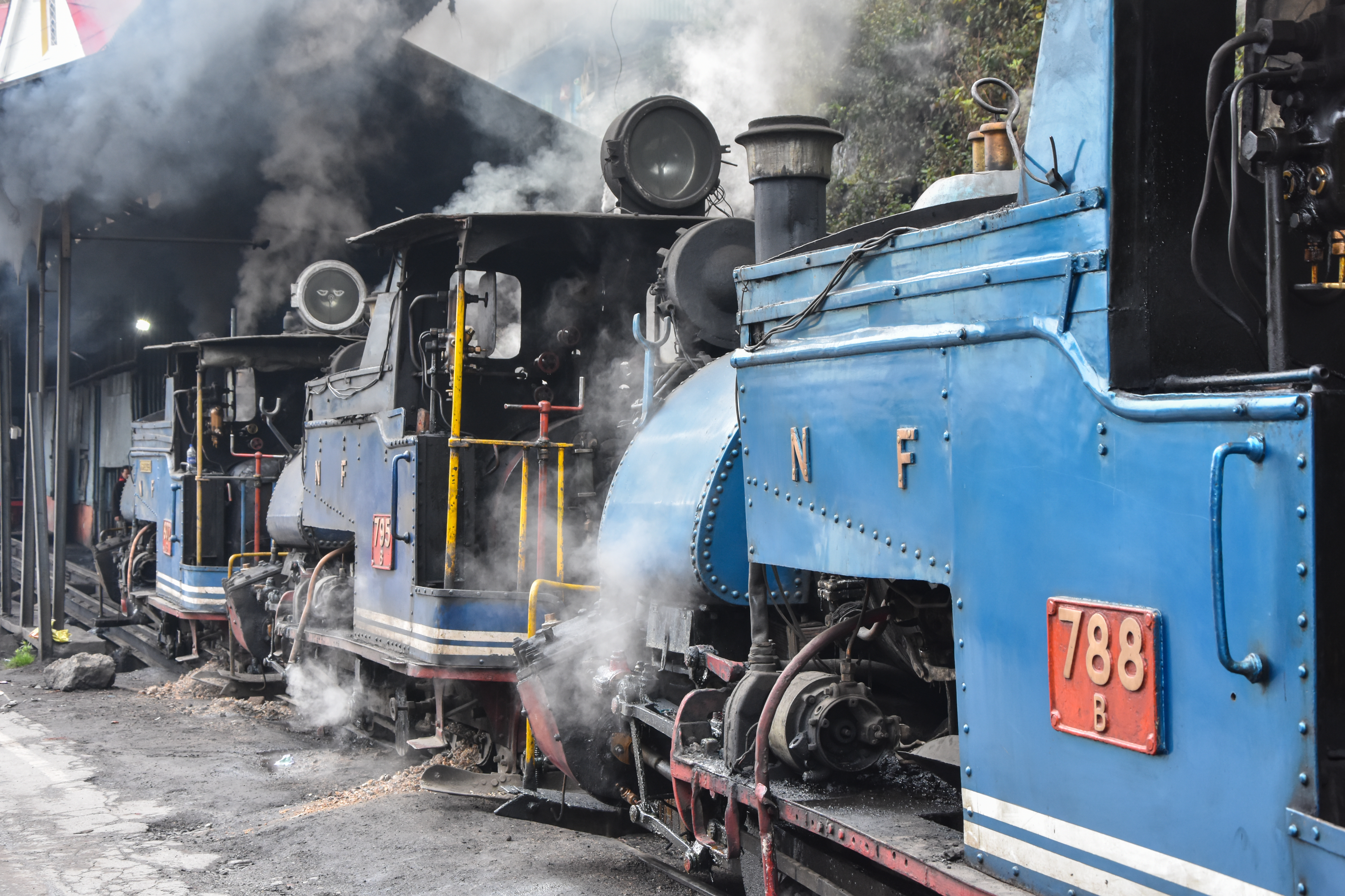
The Darjeeling Himalayan Railway climbs 1,988 metres over 88 kilometres of narrow-gauge track using no rack-and-pinion mechanism — only steam power, five Z-reversals, three loops and a sequence of spirals engineered between 1878 and 1881. Inscribed on the UNESCO World Heritage List in 1999 as the first component of the Mountain Railways of India property, it remains in active daily passenger service with B class steam locomotives, some of which were built from 1889 onward and are still in their original operational configuration. The railway’s achievement — sustained mountain climbing on 610mm gauge track without any tooth-rail assistance — had no engineering precedent when it opened.
Engineering the Climb: Loops, Reversals and the Toy Train’s Mechanics New Jalpaiguri to Darjeeling, West Bengal
Franklin Prestage, the engineer responsible for the Darjeeling Himalayan Railway’s design, faced a problem with no established solution in 1878: how to gain nearly 2,000 metres of altitude over a relatively short horizontal distance on a track too narrow (610mm, or two feet) for the heavier locomotives that powered rack-and-pinion mountain railways in Switzerland or the Harz Mountains. The solution Prestage devised used gravity, geometry and ingenuity rather than mechanically assisted traction.
The five Z-reversals, or switchbacks, are the most counterintuitive element. At each reversal, the train enters a siding pointing uphill, stops, and the locomotive — which was pushing from the rear — then becomes the leading unit as the train backs out onto the main line at a higher elevation before continuing forward again. This sequence allows the track to zigzag up a steep face without requiring tunnels or prohibitively tight curves. A single Z-reversal involves changing the train’s direction of travel twice to gain approximately 30 to 50 vertical metres.
The three loops add a different technique: the track forms a complete circle, allowing the train to gain height by spiralling upward without reversing. The most celebrated is the Batasia Loop, constructed in 1919 near Darjeeling at approximately 2,000 metres altitude. Here the track makes a full 360-degree circle — the train enters the loop heading east, completes the circuit, and emerges heading east again but at a level approximately 18 metres higher. The loop was added because the original gradient between Ghoom and Darjeeling stations (the line’s final stretch) exceeded what the locomotives could manage safely without a device to spread the altitude gain over a greater distance of track.
Agony Point, near the 7th mile from New Jalpaiguri, is a curve of only 15-metre radius on a cliff edge — among the tightest curves on any scheduled passenger railway in the world. The B class steam locomotives, built in Glasgow and later at the Tindharia workshops of the railway itself, were designed with a short wheelbase specifically to negotiate this geometry. Several B class engines with construction dates in the 1890s and early 1900s remain in regular service — making them among the oldest steam locomotives still carrying scheduled passengers anywhere.
The journey from New Jalpaiguri (88 metres above sea level) to Darjeeling (2,076 metres) takes approximately seven hours on the slower steam-hauled services and about five hours on the faster diesel services. The full steam experience — loops, reversals, tea gardens alongside the track, mountain views across the Teesta Valley — is available on tourist specials operated by the Darjeeling Himalayan Railway Society in addition to the regular Indian Railways schedule. The track passes through the town of Kurseong (1,458m) and the station of Ghoom (2,258m), the highest station on the system and one of the highest on any narrow-gauge railway in Asia.
The Other Mountain Railways: Nilgiri and Kalka-Shimla Tamil Nadu and Himachal Pradesh — UNESCO extensions 2005 and 2008
UNESCO extended the Mountain Railways of India inscription twice after the original 1999 listing. In 2005, the Nilgiri Mountain Railway was added; in 2008, the Kalka-Shimla Railway joined the property. The three components span three different Indian states, three different gauges and three different engineering philosophies for solving the same fundamental problem of mountain railway construction.
The Nilgiri Mountain Railway runs 46 kilometres from Mettupalayam (326m above sea level) to Ooty (Udhagamandalam, 2,203m) in the Blue Mountains (Nilgiri Hills) of Tamil Nadu. Its gauge is 1,000mm — broader than Darjeeling — and it uses the Abt rack-and-pinion system on its steepest sections, achieving gradients of up to 8.33 percent (1 in 12), the steepest on any Indian railway. The steam locomotives used on the lower rack section were purpose-built in Switzerland by SLM (Schweizerische Lokomotivfabrik Winterthur) specifically for this route, delivered in 1908 when the line opened. No standard locomotive could handle the combination of rack engagement, gradient and curve radius that the lower section demands. The upper section (Coonoor to Ooty) uses diesel traction on a non-rack gradient. The Nilgiri line was originally built to connect the plains to the British hill station of Ooty, which served as the summer seat of the Madras Presidency.
The Kalka-Shimla Railway, the third component, runs 96 kilometres from Kalka in the Haryana foothills (656m) to Shimla (2,076m) in Himachal Pradesh. Opened in November 1903 to a gauge of 762mm, it was built to connect the plains to Shimla, which functioned as the summer capital of British India — the entire government of the Raj, including the Viceroy, relocated to Shimla during the hot season from roughly April to October. The railway’s engineering figures are striking: 806 bridges and 102 tunnels in 96 kilometres of track. The longest tunnel, Barog Tunnel (1,143 metres), was completed in 1903 and remains in daily use. The railway carried not only passengers but also the physical infrastructure of colonial administration — files, telegraph equipment, furniture — in regular freight consignments between Delhi and Shimla for decades.
Together, the three railways represent a survey of late-19th and early-20th century mountain railway engineering applied to the specific topographic and climatic conditions of the Indian subcontinent. None of the three systems duplicates the solutions of the others; each developed independently in response to different gradients, rock types, rainfall patterns and operational requirements. UNESCO’s inscription of all three under a single property title reflects their collective significance as a group of outstanding technical achievements rather than as individual monuments.
Practical information Getting to New Jalpaiguri and Darjeeling
New Jalpaiguri (NJP) is the main rail junction for the Darjeeling region, served by long-distance trains from Kolkata (approximately 12 hours overnight), Delhi and other major cities. The nearest commercial airport is Bagdogra Airport (IXB), 4 kilometres from Siliguri and roughly 12 kilometres from NJP, with regular flights to Kolkata, Delhi and other hubs. From NJP or Siliguri, shared jeeps reach Darjeeling in about three hours via Hill Cart Road; this is the standard route for most travellers. The DHR departs NJP daily; the full steam-hauled journey to Darjeeling is scheduled in the morning. Indian Railways booking applies for regular services; the Darjeeling Himalayan Railway Society operates separate tourist joy-ride trains on a portion of the route (between Darjeeling and Ghoom) that can be booked locally.
Darjeeling’s peak season is March to May (clear skies, rhododendrons in bloom, views of Kanchenjunga) and October to November (post-monsoon clarity). The monsoon from June to September brings heavy rainfall and frequent landslides that sometimes block the railway and Hill Cart Road for days; check current track status before booking travel in this period. Elevation at Darjeeling is 2,076 metres; bring a warm layer regardless of season as evenings are cool year-round.
Frequently Asked Questions
How does the Darjeeling Himalayan Railway climb without a rack-and-pinion system?
Conventional mountain railways in Switzerland and Germany used a toothed rack rail laid between the running rails, into which a pinion gear on the locomotive meshes to provide grip on steep gradients — the Nilgiri Mountain Railway in Tamil Nadu uses exactly this system. The Darjeeling Himalayan Railway achieves altitude gain without any mechanical tooth engagement. Instead, Prestage’s design relies on two devices: Z-reversals (switchbacks) and spiral loops. A Z-reversal directs the train onto a short siding pointing uphill; it stops, then the locomotive pushes the train back out onto the main line at a higher elevation, and the train continues forward again in its original direction of travel but 30 to 50 metres higher. A spiral loop is a full 360-degree circle of track; the train enters from below, completes the circle and emerges on the inside of the loop at a higher level without any reversal. Both techniques distribute altitude gain over a greater length of track, keeping the gradient within the adhesion limits of a conventional steam locomotive on standard (non-rack) rails. The limit for adhesion traction on wet rails is approximately 2.5 to 3 percent gradient; the DHR’s ruling gradient is kept just within these parameters through the switchbacks and loops. The practical cost is distance and time: the horizontal straight-line distance from NJP to Darjeeling is about 55 kilometres, but the track covers 88 kilometres to accommodate the zigzags.
Can I ride the entire Darjeeling Himalayan Railway from New Jalpaiguri to Darjeeling in a day?
Yes, though the full steam-hauled journey from New Jalpaiguri to Darjeeling takes approximately seven hours and requires an early morning departure. Indian Railways operates the service as train number 52541 (NJP to Darjeeling) and 52542 (return); check the current Indian Railways timetable as schedules are subject to seasonal adjustment and monsoon disruptions. Diesel-hauled services cover the route faster (roughly five hours) and are cheaper; the steam experience is on the daily steam service or the dedicated tourist trains. An alternative approach that many visitors take is to travel by road from NJP or Siliguri to Darjeeling (about three hours) and then ride the shorter Darjeeling–Ghoom stretch on the Joy Ride service, which takes approximately one hour and passes through the Batasia Loop and Ghoom station — the UNESCO highlights of the system — without committing a full day to the railway. Seats on regular Indian Railways services can be booked via the IRCTC website or app; tourist joy rides are generally purchased at Darjeeling station in person.
What is the best time of year to see Kanchenjunga from Darjeeling, and does the railway offer views of the mountain?
Kanchenjunga (8,586 metres), the third-highest mountain in the world, is visible from Darjeeling and from several points along the DHR’s upper section when atmospheric conditions allow. The clearest views occur in the pre-monsoon period of March to May and in the post-monsoon period of October to November; during the monsoon (June to September) cloud cover frequently obscures the peak entirely for days at a time. Tiger Hill, about 11 kilometres from Darjeeling town, is the established viewpoint for sunrise views of Kanchenjunga and, in exceptional conditions, Everest; a shared jeep from Darjeeling market departs before dawn. The railway itself passes through the Batasia Loop, which on clear days offers a wide panorama westward toward Kanchenjunga at approximately 2,000 metres altitude — this is one of the most photographed moments on the DHR journey. Ghoom station (2,258m) is the highest point on the line and is also above the tree line, offering unobstructed sky in good conditions. The Batasia Loop was additionally landscaped after 1995 with a war memorial garden at its centre, which has made it a separate tourist destination accessible by road as well as by rail.
Sources
- S1 — UNESCO World Heritage Centre — Mountain Railways of India (Ref. 944) — https://whc.unesco.org/en/list/944/
- S2 — Wikipedia — Darjeeling Himalayan Railway — https://en.wikipedia.org/wiki/Darjeeling_Himalayan_Railway
All addresses were reachable on 20 October 2026.
Spotted an error? Write to editorial@culturalheritageonline.com and we correct it the same day.