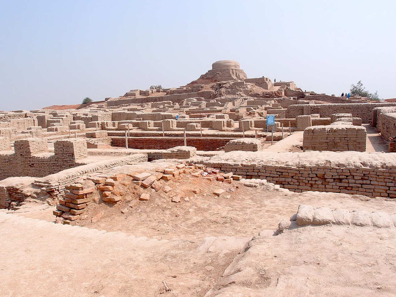
Mohenjo-daro was one of the two largest cities of the Indus Valley Civilisation, covering approximately 300 hectares at its peak between 2500 and 1900 BCE, with a population estimated at between 40,000 and 100,000 people. Its excavated remains reveal a grid-planned city with standardised brick dimensions, covered drainage channels running under every major street, and domestic flush-toilet connections to those drains — a level of urban sanitation engineering that would not reappear in most of the world for another 3,500 years. UNESCO inscribed the site in 1980; it has been on the World Heritage in Danger list since 2012 due to salt water rising through the soil and dissolving the ancient brick fabric.
The City That Archaeologists Can Read but Cannot Speak Larkana district, Sindh Province; 25 km from Larkana city, nearest airport Moenjodaro (MJD)
Mohenjo-daro was unknown to history until 1920, when R.D. Banerji of the Archaeological Survey of India visited the site while investigating a Buddhist stupa that local people knew was built on top of an older mound. His 1922 report prompted large-scale excavations that exposed a city no living tradition had preserved any memory of. The Indus Valley Civilisation — also called the Harappan Civilisation after Harappa, the other major site excavated in the same period — had been completely forgotten. No ancient Greek, Roman or Persian text mentions it. No Indian tradition of history-keeping recorded it. It vanished between approximately 1900 and 1700 BCE and was not rediscovered for three and a half millennia.
The physical evidence Banerji and subsequent excavators found was extraordinary in its uniformity and sophistication. The city was built on a grid, with straight streets oriented roughly north-south and east-west. House walls were built from kiln-fired bricks made to a standardised size ratio (approximately 1:2:4, meaning the length was four times the height and twice the width) that was consistent across sites separated by hundreds of kilometres — from Mohenjo-daro in Sindh to Harappa in Punjab to Dholavira in Gujarat. This standardisation implies a level of inter-city administrative coordination that has no parallel in the contemporary civilisations of Mesopotamia and Egypt, which used similar mud-brick technology but without the same dimensional standardisation.
The Great Bath at Mohenjo-daro measures 12 metres long, 7 metres wide and 2.4 metres deep, with a brick-paved floor, surrounding colonnaded walkways and watertight walls sealed with natural bitumen. Its precise function is debated — the most common interpretation is ritual bathing, by analogy with later South Asian practice, but this is inference rather than evidence. There are no inscriptions at the Great Bath or anywhere else on the site that explain its purpose, because the Indus script has not been deciphered.
The Indus script is one of the longest-standing unsolved problems in linguistics and archaeology. Approximately 4,000 inscribed objects (mostly stamp seals, tablets and pottery fragments) have been recovered from Indus sites; the seals are the most studied. The script uses approximately 400–700 distinct signs (the count varies by scholarly convention) and is written predominantly right-to-left. No bilingual inscription comparable to the Rosetta Stone has been found. Without a bilingual key and without any descendant language that can be confidently linked to the Indus script, the language and meaning remain inaccessible. This is not merely an academic frustration: it means that Mohenjo-daro’s rulers, gods, laws, trade agreements, religious texts and history are entirely unknown. No king’s name is recorded. No priest’s title survives. No royal tomb has been identified anywhere in the Indus Civilisation — a remarkable absence given that contemporary Egyptian pharaohs were constructing the pyramids at Giza at exactly the same period.
The absence of monumental architecture dedicated to political power or individual rulers is one of the Indus Civilisation’s most distinctive features. Mohenjo-daro has no palace, no royal burial complex, no monument bearing a ruler’s name. The largest individual structure — the so-called “Citadel” mound on the western side of the city — contains the Great Bath, a large granary-like building and a series of halls, but nothing unambiguously interpretable as a throne room or a divine-kingship monument. Some scholars interpret this as evidence of a different political structure — perhaps merchant oligarchy, or civic council — rather than centralised royal authority. Others argue that the relevant structures have not yet been found, or were made of perishable materials that did not survive. The question cannot be resolved without deciphering the script.
The Collapse Nobody Fully Understands Site in the Indus River floodplain, Sindh; seasonal flooding still affects the site
Between approximately 1900 and 1700 BCE, Mohenjo-daro was abandoned. The same process occurred across the Indus Civilisation’s entire urban network: Harappa, Dholavira, Rakhigarhi, Ganweriwala and dozens of smaller sites all show evidence of depopulation or functional decline within a roughly 200-year window. The civilisation did not simply shift its capital or reorganise under new rulers; the urban system itself ceased to function at a scale comparable to its peak, and a subsequent “Post-Urban” or “Late Harappan” phase shows greatly reduced craft specialisation, loss of the standardised brick dimensions and eventual abandonment of the script.
The proposed causes are numerous and contested. Early theories — including one promoted by archaeologist Mortimer Wheeler in the 1940s, suggesting that Aryan invaders massacred the population — have been largely abandoned. The skeletal evidence Wheeler cited (bodies found in the streets) is now interpreted as representing a late and limited episode rather than a city-wide catastrophe, and radiocarbon dating places those burials toward the very end of the city’s occupation rather than mid-period. Current scholarly consensus points toward a combination of environmental factors: the diversion or drying of the Ghaggar-Hakra River system (which may have supported as many Indus sites as the Indus River itself), prolonged drought documented in regional climate records for the 2200–1900 BCE period, and possibly shifts in monsoon patterns that reduced agricultural productivity across the region. Trade disruption with Mesopotamia — documented in cuneiform texts from approximately 2000 BCE — may have compounded economic stress. None of these explanations alone accounts for the completeness of the collapse.
The site now sits in the Indus River floodplain, and its preservation crisis is acute. The water table rises seasonally, carrying dissolved salts that crystallise in the interstices of the ancient brick and cause it to disintegrate from within. A UNESCO-funded study completed in the 1990s estimated that unchecked salt damage would destroy the exposed brick fabric within decades. Conservation interventions — including drainage systems, chemical consolidants and experimental reburial of some sections — have slowed but not arrested the process. The site was placed on UNESCO’s List of World Heritage in Danger in 2012. The Pakistani government has restricted the number of tourists permitted on the site simultaneously and has closed certain sections to foot traffic to reduce further physical disturbance.
Makli Necropolis, Rohtas Fort and the Wider Pakistani Heritage Network Makli 55 km south at Thatta; Rohtas Fort 800 km northeast in Punjab Province
The Makli Necropolis at Thatta, inscribed in 1981, lies approximately 55 kilometres south of Mohenjo-daro by the most direct route — though the road connection runs via Hyderabad (approximately 200 kilometres total by the main roads). Makli is the largest funerary complex in the Islamic world, covering approximately 10 square kilometres and containing an estimated 1.5 million graves spanning the 14th through 18th centuries. The most significant monuments are the monumental tombs of the Samma, Arghun, Tarkhan and Talpur dynasties, built in sandstone and glazed tile in a style that combines Sindhi, Central Asian and Mughal architectural traditions. Thatta itself contains the Shah Jahan Mosque (1647), built by the Mughal emperor Shah Jahan at the same time he was constructing the Taj Mahal in Agra.
Rohtas Fort, inscribed in 1997, is approximately 800 kilometres northeast of Mohenjo-daro in Punjab Province near the town of Jehlum. Built between 1541 and 1543 by the Afghan ruler Sher Shah Suri during his occupation of the Delhi Sultanate, the fort was constructed specifically to control the road between Kabul and Delhi and to suppress the Potohar Plateau tribes who supported the Mughal emperor Humayun (who Sher Shah had defeated at the Battle of Chausa in 1539). The circuit of walls is approximately 4 kilometres long, with 68 semi-circular bastions and 12 gates; the construction was completed in under two years using a workforce that contemporary accounts put at tens of thousands. Rohtas is significant as a monument of Afghan military architecture — distinct from Mughal court architecture — built at a moment when Central Asian military technology (the bastion form adapted for gunpowder weapons) was being applied to the control of South Asian territory.
Taxila, inscribed in 1980, lies approximately 900 kilometres northeast of Mohenjo-daro near Rawalpindi in Punjab. It represents a different historical arc entirely: the site was continuously occupied from the 6th century BCE through the 2nd century CE, serving as a centre of Gandharan Buddhist learning that Alexander the Great visited in 326 BCE, that the Mauryan emperor Ashoka administered in the 3rd century BCE, and that Kushan rulers patronised through the 2nd century CE. The current archaeological park contains the remains of three distinct cities — Bhir Mound (Achaemenid and early Hellenistic period), Sirkap (Hellenistic and Parthian) and Sirsukh (Kushan) — as well as dozens of Buddhist stupas and monasteries.
Practical information
Most nationalities require a visa for Pakistan, obtained in advance through Pakistani embassies or, for eligible nationalities, through the e-Visa system (evisa.gov.pk). Sindh Province, where Mohenjo-daro is located, is accessible to tourists; a No-Objection Certificate (NOC) is recommended for travel in parts of Sindh and is sometimes required by local police checkpoints. Check current travel advisories from your government before booking.
The nearest airport to Mohenjo-daro is the Moenjo Daro Airport (IATA: MJD) at Larkana, with direct flights from Karachi on PIA. The journey from Karachi by road is approximately 400 kilometres (5–6 hours) via the M-9 and National Highway 55. From Lahore, Rohtas Fort and Taxila are reachable in under three hours by motorway; Mohenjo-daro requires a domestic flight or a very long overland journey.
The cooler months — November through February — are the best period for visiting Sindh, where summer temperatures regularly exceed 45°C. The site is open daily except Fridays. An ASI-approved guide can be arranged at the site entrance; guided interpretation is strongly recommended as the ruins require contextual explanation to make full sense of the street grid and drainage system. The on-site museum holds the most important portable finds; major objects including the famous “Dancing Girl” bronze figurine and the “Priest-King” steatite bust are in the National Museum of Pakistan in Karachi. Photography is permitted throughout the site.
Frequently Asked Questions
Why has the Indus script not been deciphered despite decades of scholarly effort, and what do we actually know about the Indus Valley Civilisation’s religion and social structure?
The Indus script remains undeciphered for two compounding reasons: there is no bilingual inscription, and the underlying language is unknown. Decipherment of other ancient scripts — Egyptian hieroglyphics via the Rosetta Stone, Linear B via the recognition that it was an early form of Greek — depended on having a known language attached to the script. The Indus script’s language has no identified descendant; scholars have proposed Dravidian, Proto-Dravidian, an early Indo-European language and several other candidates, but none has generated a decipherment that the broader scholarly community accepts as demonstrated rather than speculative. There are approximately 400–700 distinct signs, a range consistent with either an alphabet-plus-ideogram system or a syllabic system. The inscriptions are short — most are under ten signs — which limits statistical analysis. Several computational studies have argued that the script encodes a natural language (rather than being a numeric or pictographic accounting system) based on its statistical entropy properties, but this does not identify the language. What is known about Indus society from archaeological evidence alone is substantial: craft specialisation was highly developed (including faience beads, bronze casting and standardised weights); long-distance trade with Mesopotamia is documented by Indus-style stamp seals found in Ur; the standardised brick dimensions and urban grid imply administrative coordination; and the absence of monumental royal architecture suggests a political system unlike contemporary Egypt or Mesopotamia — but beyond these inferences, social and religious structure cannot be described with confidence.
What is causing the physical deterioration of Mohenjo-daro and how serious is the threat?
The primary threat to Mohenjo-daro’s fabric is salt crystallisation damage caused by capillary rise of groundwater through the ancient brick. The Indus River floodplain has a naturally high water table, and irrigation of surrounding agricultural land over the past century has raised it further. Water carrying dissolved salts rises through the pores of the 4,500-year-old kiln-fired brick; when it evaporates at the surface, the salts crystallise and expand, fracturing the brick from within. The effect is gradual but cumulative: bricks that were structurally sound when excavated in the 1920s and 1930s have in many cases crumbled to soft powder by the 2020s. UNESCO placed Mohenjo-daro on its List of World Heritage in Danger in 2012 and has funded drainage improvements, monitoring and experimental chemical consolidation treatments. Some sections of the site have been deliberately re-buried — covered with earth — to slow deterioration by reducing evaporation. The conservation challenge is that the traditional approach of excavating more of the site (approximately one-third of the ancient city has been excavated; two-thirds remain buried) would expose additional fabric to the same deterioration process, while leaving it buried means it cannot be studied. Flood events — the 2022 Pakistan floods inundated large areas of Sindh — add to the risk; the site was partially flooded in 2022. Pakistan’s Archaeology and Museums Department does not have the financial resources to implement a comprehensive conservation programme without sustained international support.
Is it safe and practical to visit Mohenjo-daro as a foreign tourist, and what is the experience like on the ground?
Mohenjo-daro receives relatively few international tourists compared to South Asia’s more accessible heritage sites, and the visit is correspondingly unhurried and uncommercialized. The nearest city with reasonable hotel infrastructure is Larkana, approximately 25 kilometres north; Sukkur, about 80 kilometres north, has more accommodation options. The site itself has a small museum, a rest house operated by the government, and guides available at the entrance. The excavated area is extensive — walking the entire exposed site takes two to three hours — and the street grid, drainage channels and house foundations are legible with some background reading. The stupa mound that first alerted Banerji to the site in 1920 is still standing above the general level of excavation and gives a sense of the stratigraphy: Buddhist occupation at the top (2nd–3rd century CE), Indus city fabric below. Security in Larkana district has historically required some attention; the Pakistani government assigns tourist police escorts in some cases, and the NOC (No-Objection Certificate) process, while bureaucratic, helps establish a registered travel itinerary with local authorities. The combination of Mohenjo-daro (day one) and the Makli Necropolis at Thatta (day two, accessed via Hyderabad) makes a logical two-site Sindh itinerary, both sites being accessible from Karachi as a base.