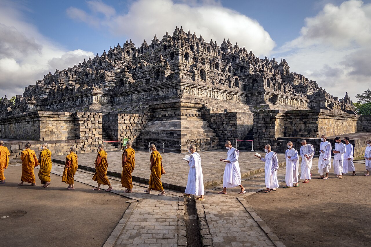
Borobudur, a 9th-century Mahayana Buddhist monument in Central Java, contains 2,672 narrative relief panels and 504 Buddha statues arranged across nine stacked platforms. Built by the Sailendra dynasty around 800 CE, it was abandoned and buried under volcanic ash and vegetation by the 10th century, remaining unknown to the outside world until 1814, when British Lieutenant-Governor Thomas Stamford Raffles dispatched engineer H.C. Cornelius to investigate a local report of a buried monument. Borobudur and Prambanan were jointly inscribed as UNESCO World Heritage Sites in 1991.
Prambanan and the Buddhist-Hindu Axis of Central Java Prambanan 40 km east of Borobudur; Mendut and Pawon temples along the same east-west pilgrimage axis
Borobudur does not stand in isolation. Two smaller Buddhist temples — Pawon and Mendut — are aligned along the same east-west axis, approximately 1.75 km and 3 km to the east of Borobudur respectively. Scholars have identified this alignment as a deliberate pilgrimage corridor: a stele inscription at Karangtengah, dated 824 CE, records that a king of the Sailendra dynasty constructed a temple and refers to a “shrine of the Buddha” that is generally interpreted as Borobudur. Annual Waisak (Vesak) ceremonies today follow this same route, with pilgrims processing from Mendut to Pawon to Borobudur on the full moon of the fourth lunar month.
Forty kilometres east of Borobudur, across the Progo River plain and the city of Yogyakarta, lies the Prambanan temple complex. Constructed in the 9th century, Prambanan represents the great Hindu counterpart to Borobudur on the same island. Its three principal shrines — dedicated to Shiva, Vishnu, and Brahma — form the core of a compound that originally contained 240 temples. The Shiva temple stands 47 metres tall, making it the tallest Hindu temple in Indonesia. Prambanan’s outer compound once held 224 smaller pervara temples arranged in four concentric rows, most of which collapsed in a catastrophic earthquake believed to have struck the region in the late 9th or early 10th century. This earthquake, combined with a shift of political power to East Java, is the most likely explanation for why both Borobudur and Prambanan were abandoned within decades of their construction.
The 2006 Yogyakarta earthquake (magnitude 6.3) caused further structural damage to Prambanan, toppling several reconstructed spires and displacing 1,500 stone blocks. Restoration work conducted by Indonesia’s Cultural Heritage Preservation Agency has continued since, with the Brahma and Vishnu temples reopened to visitors after repairs. The proximity of the active Merapi volcano — 28 km north of Prambanan — means that periodic ashfall is a recurring threat to both the stonework and the conservation infrastructure. Merapi’s 2010 eruption deposited ash across the Prambanan complex and required emergency cleaning operations.
The Borobudur monument itself consists of six rectangular terraces topped by three circular platforms, with a central main dome (dagoba) at the summit. The 72 stupas on the three circular terraces each contain a seated Buddha statue; the perforated stone lattice of each stupa allows the statues to be partially visible from outside. The entire monument is read as a mandala when viewed from above and as a cosmological journey through the Buddhist realms of existence when traversed from the base upward: the lowest galleries depict the realm of desire (kamadhatu), middle galleries the realm of form (rupadhatu), and the open upper terraces the formless realm (arupadhatu). The 2,672 narrative relief panels, if laid end to end, would extend approximately 6 kilometres.
Sangiran Early Man Site and the Broader Heritage of Java Sangiran 50 km north of Borobudur; accessible via Solo (Surakarta)
Fifty kilometres north of Borobudur, near the city of Solo (Surakarta), lies Sangiran — a site of an entirely different order of antiquity. Inscribed as a UNESCO World Heritage Site in 1996, Sangiran is one of the most important paleoanthropological sites on Earth. Approximately 50 percent of all known Homo erectus fossils in the world have been recovered from its approximately 56-square-kilometre volcanic sediment basin. The layers at Sangiran preserve 1.5 million years of continuous stratigraphy, with Homo erectus remains dating from approximately 1.5 million years ago to around 150,000 years ago.
The first fossil hominin fragments at Sangiran were identified by German-Dutch geologist Gustav von Koenigswald in 1934, building on earlier work by Eugène Dubois, who found the first Homo erectus specimens at Trinil, 90 km northeast, in 1891. The Sangiran Museum, opened in 2011, displays original and replica fossils in stratigraphic context. The site has yielded not only hominin remains but also remains of Stegodon (an extinct relative of the elephant), ancient rhinoceros species, and large bovids, providing a detailed record of the Pleistocene fauna of Java alongside its hominin inhabitants.
Java itself, with an estimated population of 140 million people across an island of 138,794 square kilometres, is one of the most densely populated landmasses on Earth. This density has directly shaped the condition of all heritage sites on the island: agricultural expansion, urban growth, and tourism infrastructure encroach on buffer zones at Borobudur, Prambanan, and Sangiran alike. The Borobudur site management plan, updated in 2023, has placed an annual cap on the number of visitors permitted to climb to the upper terraces — a measure taken in response to physical wear on the stone reliefs from foot traffic and from the oils deposited by human hands on the Buddha statues.
Yogyakarta, the nearest major city to Borobudur, serves as the base for most visits. The city’s Kraton (royal palace), still the ceremonial seat of the Sultanate of Yogyakarta, lies at the axis of a north-south cosmological alignment running from Merapi through the palace to the Indian Ocean — a spatial organisation that mirrors, at an urban scale, the cosmological structuring of the Borobudur monument itself. The Sultanate of Yogyakarta was the institution that first alerted Dutch colonial authorities to Borobudur’s location after Raffles’s departure.
Practical information Central Java, Indonesia; nearest airports Yogyakarta (YIA) and Solo (SOC)
Yogyakarta International Airport (YIA) and Adisumarmo International Airport in Solo (SOC) both serve domestic routes connecting Central Java to Jakarta, Bali, and Surabaya. International connections are available via Jakarta (CGK) or Bali (DPS). Borobudur is approximately 40 km northwest of Yogyakarta city centre; Prambanan is 18 km east. Travel time between Borobudur and Prambanan is approximately 1.5 hours by road, making a combined visit feasible in a single day with an early start.
Entry to the Borobudur complex requires a ticket (approximately IDR 750,000 / USD 45 for international visitors as of 2024); access to the upper terraces requires a separate permit and sarong (provided on-site). Visits before 08:00 offer lower visitor density. Prambanan has separate admission (approximately IDR 350,000 for international visitors). The dry season (May–September) is the most reliable period for clear views and road access. Humidity is high year-round; lightweight clothing and sun protection are essential on the open upper terraces at Borobudur. The Indonesian rupiah (IDR) is the only accepted currency at ticket offices. ATMs are available in Magelang (15 km from Borobudur) and throughout Yogyakarta. Visa-free entry applies to citizens of approximately 90 countries for stays up to 30 days; for longer stays, a visa on arrival (IDR 500,000 / USD 35) is available at major international airports.
Frequently Asked Questions
How was Borobudur discovered, and what was its condition when Raffles sent Cornelius to investigate in 1814?
By 1814, Borobudur had been covered by centuries of volcanic ash from Merapi and overgrown by dense tropical vegetation. Local Javanese were aware of its existence — they called it “Candi Borobudur” (candi meaning a Hindu-Buddhist sanctuary) — and it appears in at least one 18th-century Dutch administrative report, but no systematic investigation had been conducted. Thomas Stamford Raffles, who governed Java on behalf of the British East India Company during the brief British interregnum (1811–1816), received a report from his local administrator in the Kedu Plain and in August 1814 sent H.C. Cornelius, a Dutch engineer, to investigate. Cornelius found the structure buried to a depth of several metres in volcanic debris and jungle growth. He employed between 200 and 500 local workers over two months to clear vegetation from approximately half the monument, revealing the general outline of the structure. Raffles published a description and drawings of the monument in his 1817 book “The History of Java.” The Dutch colonial government subsequently undertook more systematic documentation, and a full restoration — the first — was conducted between 1907 and 1911 under Theodoor van Erp. The most comprehensive restoration occurred between 1975 and 1982 under a UNESCO-coordinated international effort, during which over one million stones were dismantled, catalogued, cleaned, and reassembled with modern drainage infrastructure installed beneath the structure to address water infiltration damaging the foundations.
What do the 2,672 relief panels at Borobudur actually depict?
The relief panels at Borobudur are organised into distinct narrative and decorative series corresponding to the monument’s three cosmological zones. The lowest visible series (the first gallery) depicts the Mahakarmavibhanga — a text on the law of karma showing the consequences of good and bad deeds in this life and the next. Above these, the first and second galleries contain 120 panels illustrating the Lalitavistara, the biography of the historic Buddha Siddhartha Gautama from his descent from the Tushita heaven through his first sermon at the Deer Park in Sarnath. The Jataka tales — stories of the Buddha’s previous lives — occupy a further series of 372 panels across the first and second galleries, along with the Avadana tales (stories of exemplary deeds by bodhisattvas and lay persons). The third and fourth galleries are dominated by the Gandavyuha — a lengthy Mahayana text describing the pilgrim Sudhana’s search for enlightenment through encounters with 52 spiritual teachers. The Gandavyuha panels alone account for approximately 460 reliefs. Together, the narrative panels function as a visual library of Mahayana Buddhist doctrine, arranged so that a pilgrim circumambulating each level in the ritual clockwise (pradaksina) direction would encounter the teachings in their correct doctrinal sequence, ascending from desire through form to formlessness as they climbed the monument.
Is Merapi volcano a genuine risk to visiting Borobudur and Prambanan?
Merapi is one of the most active volcanoes in the world, with recorded eruptions dating back to the 9th century and major events in 1930, 1994, 2006, and 2010. The 2010 eruption was the largest in a century, producing pyroclastic flows that killed 353 people and displaced 350,000. The summit of Merapi is approximately 28 km north of Prambanan and 40 km northeast of Borobudur. At that distance, the primary risks to visitors during a standard eruption are ashfall, which can reduce visibility, close airports, and coat heritage sites, and the psychological uncertainty of proximity to an active vent. Pyroclastic flows in the 2010 eruption extended approximately 15 km from the summit, well short of either heritage site. The Indonesian Centre for Volcanology and Geological Hazard Mitigation (PVMBG) maintains a four-level alert system for Merapi and publishes real-time status updates. Alert Level 1 (Normal) and Level 2 (Advisory) do not restrict tourism at Borobudur or Prambanan. Level 3 (Watch) may trigger closures of approaches toward the summit; Level 4 (Warning) involves evacuation zones that could affect some access roads. Checking the PVMBG status before and during a visit is straightforward via their official website. The Yogyakarta airport (YIA), built in Kulon Progo to the west specifically to reduce ashfall risk to air operations, provides better resilience than the old Adisucipto Airport, which closed to most traffic in 2020.