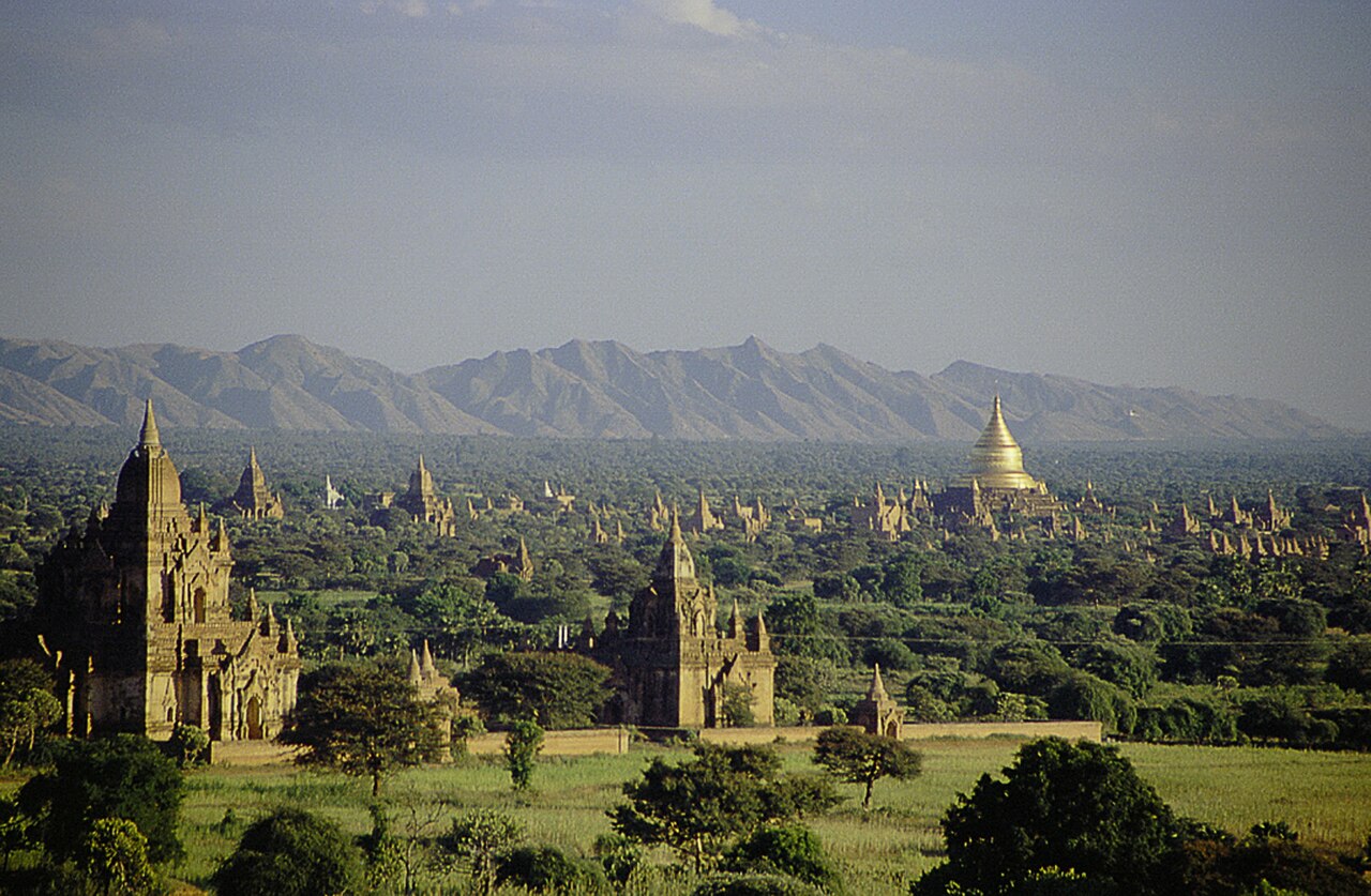
Bagan is an archaeological zone of approximately 67 km² on the Irrawaddy River in central Myanmar’s Mandalay Region, containing around 3,500 surviving Buddhist pagodas, temples, and monasteries — the remnants of a city that held an estimated 10,000 religious structures at its peak between the 9th and 13th centuries CE. The site received UNESCO World Heritage status in 2019, after decades of delays rooted in disputes over how Myanmar’s government restored earthquake-damaged monuments. A 2016 earthquake measuring 7.0 in magnitude damaged approximately 400 pagodas; restoration continues across the zone today.
The Pagan Kingdom and the Politics of Monument-Building Mandalay Region, Central Myanmar
The Pagan Kingdom established Bagan as its capital in 849 CE and held it until 1297 CE, when the kingdom collapsed under pressure from Mongol invasions and internal fragmentation. During those four centuries, the construction of religious monuments became simultaneously an act of Buddhist merit-making and a form of political competition. Kings, queens, nobles, and wealthy merchants all built pagodas and temples — and the larger, more elaborate the structure, the greater the merit accrued and the more visible the builder’s status. The result was a city whose skyline was dominated almost entirely by religious architecture, rising from the flat alluvial plain in a density unmatched anywhere else in the Buddhist world.
The peak building period ran from approximately 1050 to 1280 CE. King Anawrahta, who unified much of what is now Myanmar under Pagan rule in 1044 CE, established Theravada Buddhism as the kingdom’s dominant tradition and initiated the first major phase of monumental construction. He began the Shwezigon Pagoda — one of the earliest structures built in the distinctly Burmese bell-shaped stupa form — which his successor King Kyanzittha completed in 1102. Kyanzittha also commissioned the Ananda Temple in 1105 CE, one of the best-preserved monuments in the entire zone. The Ananda is cruciform in plan, with a terraced exterior rising to a central gilded spire, and it houses four 9-metre gilded standing Buddhas facing the cardinal directions. The interior corridors are designed so that walking toward the Buddhas makes them appear to frown — a deliberate optical effect reflecting the solemn weight of the Dharma — while standing directly beneath them reveals a benevolent downward gaze.
Among the most architecturally striking structures is the Dhammayangyi Temple, built in the 12th century and the largest temple by footprint in Bagan. Its construction is renowned for the precision of its brickwork: the courses are laid so tightly that a pin cannot be inserted between them — a specification reportedly enforced by King Narathu, who had the hands of masons cut off if the brickwork was not deemed sufficiently tight. The inner sanctum of the Dhammayangyi was mysteriously sealed at some point after Narathu’s death (he was assassinated in 1170 CE), and the reason has never been definitively established; one tradition holds that it was sealed as punishment for his crimes, including the murder of his father and brother. The sealed chambers have never been fully excavated.
The 1975 earthquake caused widespread damage across the zone, and the Myanmar government’s subsequent reconstruction program proved deeply controversial. Damaged temples were repaired using cement render, modern brick, and construction methods that were archaeologically incompatible with the original structures. UNESCO refused to inscribe Bagan on the World Heritage List for decades because of these interventions. Negotiations stretched across successive rounds of documentation and restoration review before the site finally met sufficient standards for inscription in 2019 — making Bagan one of the most delayed World Heritage inscriptions in the modern history of the List.
Reading the Temple Plain: From Shwezigon to the Sealed Sanctum 67 km² Archaeological Zone
Bagan is conventionally divided into three zones: Old Bagan (the original walled city, now largely cleared of modern habitation), Myinkaba village to the south, and New Bagan further south still — the settlement where residents were relocated in 1990 when the military government cleared the core archaeological zone. Navigating the plain requires a deliberate approach; the sheer number of structures means that most visitors develop a mental map of priority sites and then allow time for unplanned discovery among the hundreds of smaller, unlabelled pagodas that line every track and field boundary.
The Shwezigon Pagoda, just north of Old Bagan, is an active place of worship and pilgrimage rather than a purely archaeological site. Its bell-shaped gilded stupa was a prototype for the Burmese stupa form that subsequently spread across the country and influenced Buddhist architecture throughout mainland Southeast Asia. The pavement around the stupa is lined with 37 nat shrines — the nats being the pre-Buddhist spirit beings that Anawrahta incorporated into the new Theravada order by installing their images around the pagoda, a pragmatic act of religious integration that acknowledged the persistence of indigenous belief alongside the new state religion.
The Htilominlo Temple, built in 1218 CE, is one of the last large temples constructed before the kingdom’s decline and demonstrates the fully developed three-storey Bagan temple type, with stucco carvings of kirtimukha (glory-face) demons, floral designs, and astrological imagery still partially surviving on the exterior. Nearby, the Sulamani Temple (1183 CE) shows the mature Bagan aesthetic: a double-storey structure with corner towers, frescoes of Jataka tales (stories of the Buddha’s former lives) on the interior walls, and the characteristic terracotta tiles that give the Bagan plain its warm reddish tones at dawn and dusk.
The 2016 earthquake caused the collapse of spires and upper sections across the zone. The ongoing restoration program is conducted in collaboration with international conservation bodies and has adopted stricter standards than the post-1975 work — using lime mortar rather than cement, matching original brick dimensions, and prioritising structural stabilisation over cosmetic completion. Some damaged monuments remain visibly incomplete by design, since the alternative would require interventions that would compromise future re-intervention possibilities as methods improve.
Practical information
Bagan is reached by air from Yangon (approximately 1 hour 20 minutes) or Mandalay (approximately 35 minutes); several airlines serve Nyaung-U Airport, the gateway town for the archaeological zone. Overland buses connect Bagan with Yangon (approximately 9 hours) and Mandalay (approximately 7 hours); overnight services are the standard option. Slow boat services on the Irrawaddy between Mandalay and Bagan take approximately 10 hours downstream and longer upstream, and are available seasonally depending on river levels.
The Bagan Archaeological Zone entrance fee is required for all visitors. Electric bicycles (e-bikes) are the most practical way to navigate the plain; bicycle hire is also widely available. Horse carts provide a slower alternative on the sandy tracks between temples. Balloon flights over the plain operate in the dry season (roughly November to March) and require advance booking. The Archeological Museum in Old Bagan provides stratigraphic and chronological context for the site. Visitors should note that parts of Myanmar are subject to travel advisories; checking current conditions from reliable sources before travel is advisable. The best light for photography falls in the hour after sunrise and the hour before sunset.
Frequently Asked Questions
Why did UNESCO take so long to inscribe Bagan as a World Heritage Site?
Bagan was a serious candidate for UNESCO World Heritage inscription for many years before it finally received the designation in 2019, but the site’s nomination was repeatedly blocked or deferred because of the restoration methods employed by the Myanmar government after the 1975 earthquake. Following that earthquake, hundreds of damaged pagodas and temples were repaired using Portland cement, modern brick that did not match original dimensions, and construction techniques that archaeologists and conservation specialists considered incompatible with authentic heritage preservation. UNESCO’s operational guidelines for World Heritage listing require that sites demonstrate outstanding universal value and meet standards of integrity and authenticity — standards that the post-1975 reconstruction work in Bagan was judged not to meet. Over subsequent decades, the government undertook additional projects that further complicated the picture, including the construction of a viewing tower in the archaeological zone and the relocation of thousands of residents from Old Bagan to New Bagan in 1990. Negotiations between the Myanmar government and UNESCO’s World Heritage Committee were lengthy and required the government to adopt new restoration protocols, accept international archaeological oversight, and demonstrate measurable improvements in how conservation work was carried out. The 2019 inscription followed years of revised conservation planning and represented a determination that, while the site’s fabric had been compromised by past interventions, the outstanding universal value of the Bagan complex remained legible and the government’s current approach was sufficiently aligned with international standards.
What is the significance of the sealed inner sanctum of the Dhammayangyi Temple?
The Dhammayangyi Temple is the largest temple in Bagan by footprint, built in the 12th century CE during the reign of King Narathu, who came to power after killing his father, King Alaungsithu, and his brother. Historical accounts describe Narathu as a builder obsessed with perfection — masons whose brickwork he judged insufficiently tight reportedly had their hands amputated — and the Dhammayangyi was intended to be his defining monument. Narathu was assassinated in 1170 CE by Indian emissaries, according to one tradition, in revenge for his murder of an Indian queen who was part of his household. At some point after his death, the inner passageways of the Dhammayangyi were filled with brick and sealed, blocking access to the innermost sanctuary. The reason for this sealing has never been definitively established from archaeological or textual evidence. One tradition holds that it was done deliberately by Narathu’s successors as a form of damnatio memoriae — a denial of his legacy and a punishment for his crimes — while other interpretations suggest structural instability or a later renovation project that was never completed. The sealed chambers have been investigated from the exterior and through ground-penetrating techniques, but have not been fully excavated. The mystery is one of the most frequently discussed aspects of Bagan’s archaeology, combining political history, architectural detail, and unresolved physical evidence.
How did the 2016 earthquake affect Bagan’s temples and what restoration work has followed?
The August 2016 earthquake, measuring 7.0 in magnitude and centred approximately 25 km from Bagan, caused damage to an estimated 400 pagodas and temples across the archaeological zone. The effects ranged from collapsed finials and upper spires — common on the taller brick structures, whose pointed tops are structurally vulnerable — to partial wall failures and the displacement of decorative stucco panels. Some smaller, less structurally stable monuments suffered more severe damage. The earthquake occurred during a period of heightened international scrutiny of Myanmar’s heritage conservation practices, and the restoration response was consequently developed with greater attention to international conservation protocols than previous post-disaster work. The restoration program has involved collaboration between Myanmar’s Department of Archaeology, UNESCO, and bilateral partners, and has prioritised the use of materials and techniques compatible with original construction — lime mortar rather than cement, brick matching original dimensions sourced from compatible quarries, and documentation of pre-intervention conditions. Some damaged monuments have been deliberately left in a stabilised but visually incomplete state, on the principle that future restoration technology and methodology may improve and that premature completion using current methods could foreclose better options. Restoration across the 67 km² zone is ongoing; the scale of the task, combined with the need to maintain archaeological standards across hundreds of discrete structures, means the program is expected to continue for many years.