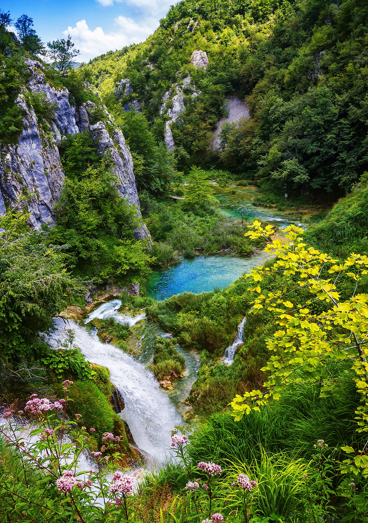
Sixteen terraced lakes connected by waterfalls, covering 296 square kilometres of karst forest in central Croatia — Plitvice Lakes National Park has been a UNESCO World Heritage Site since 1979 and remains Croatia’s oldest and largest national park. The lakes’ turquoise colour shifts with the angle of light and the season, produced by dissolved calcium carbonate and magnesium. The travertine barriers that form the waterfalls are still growing, built up millimetre by millimetre each year by microorganisms, and visitors are prohibited from touching the water.
Sixteen Lakes, Living Waterfalls, and the Chemistry Behind the Colour Central Croatia — 2 hours from Zagreb or Split
The sixteen lakes of Plitvice divide into two groups: the Upper Lakes (Gornja jezera), a wider, shallower plateau in a dolomite valley, and the Lower Lakes (Donja jezera), a narrower canyon where the water drops through a series of cascades before reaching the lowest point of the system. The Korana River eventually flows out from the base of the Lower Lakes through a gorge of high grey limestone walls. The total drop in elevation across the lake system is approximately 133 metres.
The turquoise-to-emerald colour of the water results from dissolved minerals — primarily calcium carbonate (calcite) and magnesium compounds — that alter the way light scatters and absorbs within the water column. The shade shifts noticeably with season, weather, and angle of sunlight: palest aquamarine in overcast winter light, deepest turquoise on sunny summer afternoons, greener in the shade of the surrounding forest. This variability is part of what makes the park visually distinctive across different visits.
The waterfalls and lake barriers are formed by travertine, also called tufa — a porous limestone sediment precipitated from the water as calcium carbonate by cyanobacteria, algae, mosses, and other microorganisms living in the water and on submerged surfaces. As the organisms extract carbon dioxide from the water during photosynthesis, calcium carbonate comes out of solution and deposits around them, slowly building the barriers that dam each successive lake. The travertine is alive in the literal sense: the microorganisms and mosses that form it are actively growing, and the barriers change shape and height over time. This is why visitors must not touch the water — human skin oils and sunscreen chemicals disrupt the delicate microbial communities that maintain the entire system.
The park contains 1,267 recorded plant species and supports populations of brown bear, grey wolf, lynx, red and roe deer, wild boar, and rare bird species including the black stork and the white-tailed eagle. The beech and fir forests surrounding the lakes are largely undisturbed, their canopy contributing to the cool microclimate that keeps the travertine system functioning through hot summers. Visiting in late autumn or winter, when the park is less crowded, reveals the geological structure of the site more clearly as leafless trees open views across the canyon walls.
Veliki Slap, the War of Independence, and the Park’s Road Back to UNESCO Monitoring Main entrance gates 1 and 2 — accessible by shuttle bus
The most dramatic single feature of Plitvice is Veliki Slap — the Great Waterfall — at 78 metres the tallest waterfall in Croatia and one of the tallest in southeastern Europe. It drops as a single curtain of water from a travertine cliff at the junction of the Upper and Lower Lakes, with mist rising from the plunge pool on all but the calmest days. The viewpoint opposite Veliki Slap is accessible via a network of wooden boardwalks that traverse the Lower Lakes at water level — one of the most unusual walking experiences in Europe, with the boardwalk surface visibly submerged in a few centimetres of clear water at high lake levels.
The park’s history carries a weight that its landscape does not immediately announce. On 31 March 1991, the park became the site of the first armed confrontation of the Croatian War of Independence. A skirmish between Croatian police and Serbian forces — the so-called “Battle of the Plitvice Lakes” — left several dead and wounded on both sides and marked the transition from political confrontation to open conflict. The park was subsequently occupied by the Serbian Republic of Krajina and remained under occupation until August 1995, when Croatian forces retook the area during Operation Storm. During the occupation, infrastructure was damaged, some wildlife populations were disrupted, and park management was suspended.
After Croatian control was restored in 1995, UNESCO placed the park on its List of World Heritage in Danger — a designation that triggers closer monitoring and requires the affected state to submit restoration reports. Plitvice was removed from the danger list once rehabilitation of the park’s management systems and infrastructure was confirmed. The episode left its mark on the park’s institutional history and on the wider narrative of UNESCO’s role in protecting heritage during active conflict.
Today the park receives over 1.5 million visitors per year, making it one of the most-visited natural sites in southeastern Europe. This volume has created significant management pressure, and the Croatian authorities have implemented timed entry slots, daily visitor caps at peak season, and strict circulation routes to protect the travertine system from compaction and chemical contamination. Advance booking is now essentially mandatory from June through September.
Practical information
Plitvice Lakes National Park has two main entrance gates: Entrance 1 (for the Lower Lakes and Veliki Slap) and Entrance 2 (for the Upper Lakes). Both are served by free shuttle buses and electric boats that circulate within the park. A full circuit of both lake groups takes 4 to 8 hours on foot depending on the route chosen; the park provides detailed trail maps at the gates.
The park is approximately 2 hours from Zagreb (130 km south on the A1 motorway, then local road) and 2 hours from Split (180 km north). Regular bus services from Zagreb and Split stop at both entrances year-round. Private car access is limited to designated car parks outside the park boundary.
Entry fees in 2024 ranged from €10 (off-season, November to March) to €35–40 (peak summer, July–August), with graduated pricing across spring and autumn. Booking online in advance is strongly recommended from April through October, as the daily cap sells out days or weeks ahead in summer. The best months for smaller crowds and lower prices are April, May, October, and November; autumn colour in October is particularly striking. Snow in winter covers the wooden boardwalks and the park closes some circuits; check conditions before visiting between December and February.
Accommodation is available at the Park Hotel within the park boundary and at guesthouses in the villages of Mukinje and Rastovača immediately adjacent. The nearby town of Slunj (15 km north) provides additional options.
Frequently Asked Questions
How do the travertine barriers at Plitvice Lakes form, and why are visitors not allowed to touch the water?
Travertine — sometimes called tufa in this geological context — forms through a biological and chemical process that operates at the interface between flowing water and living organisms. The water flowing through the Plitvice system is rich in dissolved calcium bicarbonate, which it picks up by percolating through the limestone bedrock of the surrounding karst plateau. When this calcium-rich water flows over surfaces colonised by cyanobacteria, algae, mosses, and other photosynthetic microorganisms, those organisms absorb carbon dioxide from the water as part of their metabolic processes. Removing CO₂ from the solution shifts the chemical equilibrium and causes calcium carbonate to come out of the water as solid calcite crystals, which then deposit around the organisms’ cells and fibres. Over time, layer upon layer of calcite builds up, encasing the organic material and gradually forming the porous, sponge-like barriers that dam each successive lake. The process is continuous and active: the barriers at Plitvice are growing today, though at rates of millimetres per year. The prohibition on touching the water stems from this biological sensitivity. Sunscreen chemicals, skin oils, insect repellent, and soap residues are toxic to the microorganisms at the concentrations they would reach if many thousands of visitors contacted the water directly. Disruption of the microbial communities would slow or halt travertine deposition, potentially causing barrier erosion and changing the entire lake system over decades. The wooden boardwalks, the shuttle boats, and the strict circulation routes all exist primarily to protect this living geological process rather than simply to manage visitor flow.
What happened at Plitvice Lakes during the Croatian War of Independence, and how did the park recover?
The Plitvice Lakes held a dual symbolic and strategic significance at the beginning of the Croatian War of Independence. Symbolically, the park was Croatia’s most internationally recognised natural landmark — placing it under Serbian control was a statement about territorial claims in the Krajina region. Strategically, the park controlled road access through the central Croatian highlands. On 31 March 1991 — before Croatia had formally declared independence — Croatian special police units entered the park to reassert control after Serbian irregulars had established a presence there. The confrontation that followed, known as the Plitvice Lakes incident or the “Easter Sunday battle,” lasted several hours and left at least two dead and multiple wounded. It is widely cited by historians as the first armed clash of the war. Over the following months, Serbian forces consolidated control of the wider Krajina region, and Plitvice remained under occupation from the summer of 1991 until August 1995, when Operation Storm returned the area to Croatian authority. During the occupation, park infrastructure was damaged and some scientific monitoring was suspended, though the lake system itself was not severely altered. After reintegration, the Croatian government undertook rapid rehabilitation of the park’s facilities, and UNESCO removed Plitvice from the World Heritage in Danger list once restoration of management systems was confirmed. The park reopened to international tourism and visitor numbers recovered relatively quickly, reaching pre-war levels within a few years and subsequently growing to over 1.5 million annually.
How do Plitvice Lakes connect to other UNESCO World Heritage Sites in Croatia, and is a multi-site visit practical?
Croatia has ten UNESCO World Heritage Sites, and Plitvice Lakes sits geographically between two of the most visited: the Historic Complex of Split with Diocletian’s Palace, 180 km to the south, and the Old City of Dubrovnik, 280 km south. Both are reachable from Plitvice by car or bus in under three hours. A practical three-site itinerary works as follows: Zagreb (Plitvice as a day trip or overnight) → Split (Diocletian’s Palace, day trip to Hvar for the Stari Grad Plain) → Dubrovnik (2–3 nights). This circuit covers four UNESCO inscriptions in approximately 8–10 days and can be driven in full or combined with the Jadrolinija ferry network linking Split and Dubrovnik along the Dalmatian islands. The Stari Grad Plain on Hvar island — a UNESCO-inscribed ancient Greek agricultural landscape dating to the 4th century BCE, with chora field divisions still visible from above — is reached by a 60-minute car ferry from Split to Stari Grad. Extending the itinerary northward from Plitvice adds the historic city of Trogir (30 km from Split, UNESCO-inscribed for its medieval Venetian urban core) and the early Christian complex of Euphrasius Basilica in Poreč on the Istrian coast. Croatia’s concentration of UNESCO sites along a relatively compact coastal corridor makes it one of the most efficient countries in Europe for multi-site heritage travel.