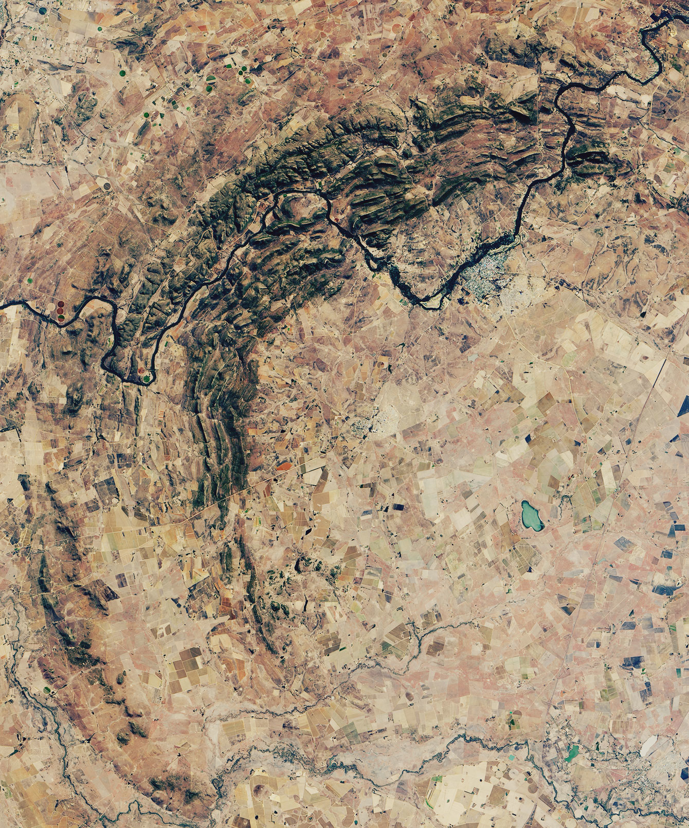
The Vredefort Dome in South Africa’s North West Province is the Earth’s largest and oldest confirmed meteorite impact structure, formed approximately 2,023 million years ago during the Paleoproterozoic era. A UNESCO World Heritage Site since 2005, it preserves the most complete and least-altered record of a large impact event available anywhere on the planet. The town of Parys, roughly 110 kilometres southwest of Johannesburg, serves as the closest service base for visitors.
Reading the rocks: what the impact left behind North West Province, ~120 km SW of Johannesburg
When an asteroid estimated at 10 to 15 kilometres in diameter struck what is now the South African highveld approximately 2,023 million years ago, it excavated a transient cavity roughly 300 kilometres wide — the largest verified impact scar on Earth. Over the subsequent two billion years, erosion stripped away the outer rings of the structure, leaving a 40 to 50 kilometre central dome of uplifted Archaean basement rock exposed at the surface today. The resulting landscape gives little visual hint of the scale of the original event, but the rocks within the dome carry unambiguous evidence of pressures and temperatures that no volcanic or tectonic process can replicate.
Three categories of geological evidence confirm the impact origin and draw specialists from around the world. The first is pseudotachylite — a dark, glassy rock formed when target material melted under extreme shock pressure and refroze almost instantaneously. Veins of pseudotachylite cut through the surrounding granite and quartzite in road cuts and outcrops throughout the dome area, sometimes running for several metres. They are one of the most visually accessible features for a non-specialist visitor: dark streaks in pale rock, marking the exact zones where solid stone briefly became liquid under impact loading.
The second diagnostic feature is shatter cones — striated, cone-shaped fractures whose apex points back toward the impact centre. Vredefort contains some of the best-developed and largest shatter cones documented anywhere on Earth; individual specimens can reach a metre or more in length. Tracing the geometry of a shatter cone back to the point of impact provides a tangible sense of directionality in an event that preceded complex life on this planet by more than a billion years.
The third and broadest feature is the circular geology itself: concentric rings of deformed strata radiating outward from the central dome, recording the collapse of the transient impact cavity as it rebounded and settled in the minutes after the strike. The scientific case for an impact origin was established definitively in the 1960s by geologist William Hamilton, who identified the shatter cones decades after geologist Robert Ball had described the anomalous circular structure as a “cryptoexplosion” in 1894, without being able to explain its cause. The UNESCO inscription of 2005 recognised Vredefort precisely because its combination of age and exposure makes it the most scientifically complete large impact record available on Earth.
The Witwatersrand gold connection Geological basin extending eastward toward Johannesburg
The Vredefort impact did not occur in geological isolation. It struck at the northwestern edge of the Witwatersrand Basin — a sedimentary structure that contains approximately 40 percent of all the gold ever mined in human history. The relationship between the impact and the gold remains one of the most actively debated questions in South African economic geology.
The gold-bearing reefs of the Witwatersrand were deposited as sediments in a Paleoproterozoic inland sea between roughly 3 and 2.7 billion years ago, predating the impact by several hundred million years. The asteroid strike deformed the basin geometry significantly: sections of the gold reefs were rotated, tilted, and in some areas brought to depths accessible to mining that they would not otherwise have reached. Hydrothermal fluids moving through the intensely fractured crust in the immediate aftermath of the impact may also have remobilised gold into specific zones. Researchers continue to debate the precise mechanism — whether the impact concentrated gold, exposed it, or primarily preserved basin geometry that protected the reefs from later erosion — but the economic and historical consequences are beyond dispute.
The town of Parys, population approximately 30,000, sits within the outer arc of the dome on the Vaal River. Its name comes from a homesick surveyor who founded the settlement in 1882 and named it after the French capital. The surrounding landscape of rounded granite kopjes and farmland gives no immediate visual hint of the cataclysm beneath. Visitor infrastructure is minimal: there is no dedicated visitor centre, and most significant geological features are located on private farmland and require local guide knowledge to find and interpret. The Vredefort Dome Conservancy in Parys maintains basic information and guide contacts; several local operators offer half-day and full-day geological tours that are the only reliable way to access the key outcrops.
Practical information
The Vredefort Dome lies approximately 120 kilometres southwest of Johannesburg, reached by road via the N12 or N14 highways toward Potchefstroom and then south toward Parys. The drive takes roughly 90 minutes from central Johannesburg under normal conditions. There is no public transport to the site; a rental car or an organised tour from Johannesburg is the standard approach. Parys has a range of guesthouses and small hotels along the Vaal River, making it a practical overnight base.
The best season for visiting is the South African winter, April through September, when days are dry and temperatures are comfortable for outdoor walking, typically 15–22°C during daylight hours. Summer months (October–March) bring afternoon thunderstorms that can make outdoor rock interpretation difficult and some farm tracks impassable. There is no entry fee to the broader dome area, but guided tours with local operators typically cost between ZAR 500 and ZAR 1,500 per person depending on duration and group size. Bring sturdy walking shoes, water, sun protection, and a hand lens if you want to examine pseudotachylite veins or shatter cone surfaces up close. A local geological guide is strongly recommended — without one, the significant outcrops are difficult to locate, access to private land requires prior arrangement, and the features themselves are not labelled.
Frequently Asked Questions
Why is Vredefort called the world’s largest impact crater if only a 40–50 km dome is visible today?
The apparent discrepancy comes from the difference between the original crater diameter and what erosion has preserved at the surface. When the asteroid struck approximately 2,023 million years ago, it excavated a transient cavity estimated at 300 kilometres across — by far the largest verified impact scar on Earth. Over the following two billion years, geological processes removed the outer rings: uplift exposed deep rocks to erosion, wind and water stripped away material, and later sediments buried parts of the structure. What remains visible today is the central uplift dome, roughly 40 to 50 kilometres across, where the deepest basement rocks were forced upward by the rebound that followed impact. Geologists reconstruct the original 300 kilometre diameter by tracing the distribution of shock metamorphism features — pseudotachylite veins, shatter cones, and high-pressure mineral phases such as coesite and stishovite — which appear in a pattern consistent only with a structure of that scale. Other large impact structures, such as Chicxulub in Mexico (responsible for the end-Cretaceous extinction, estimated at roughly 180 km) or Sudbury in Canada (approximately 200 km after deformation), are younger or differently preserved. None matches Vredefort’s combination of age, original size, and degree of geological exposure, which is why the 2005 UNESCO inscription emphasised its value as the most complete record of a large impact available on Earth.
How is the Vredefort impact connected to South Africa’s gold mining industry?
The connection runs through the Witwatersrand Basin, which underlies much of Gauteng Province and produced roughly 40 percent of all the gold ever extracted by humans. The gold-bearing sedimentary reefs were deposited between approximately 3 and 2.7 billion years ago — hundreds of millions of years before the Vredefort impact — in an ancient inland sea. The asteroid strike then deformed the basin geometry dramatically: sections of the gold reefs were tilted, rotated, and in some zones brought to depths that became accessible to the mining technology of the late 19th century. Without this structural disruption, many of the richest reefs would lie either too deep to mine economically or would have been eroded away entirely. Hydrothermal fluids circulating through the shattered crust in the immediate aftermath of the impact may also have locally concentrated gold in specific zones, though the exact mechanism is still debated. What is agreed is that the Vredefort event significantly shaped the geometry of the Witwatersrand goldfields, and that without it the 1886 gold rush — which led directly to the founding of Johannesburg, the Anglo-Boer Wars, and the subsequent political and economic history of southern Africa — would have followed a very different course. Standing in the Vredefort Dome, a visitor is standing at the source of consequences that reverberated through modern history.
What can a visitor actually see at Vredefort, and is a guide necessary?
Without a guide, the Vredefort Dome area looks like ordinary South African highveld: rounded granite kopjes, farmland, and the Vaal River. The geological features that justify World Heritage status require knowing precisely where to look and how to read what you find. Road cuts along rural roads near Parys expose pseudotachylite veins — dark, glassy streaks where impact-melted rock refroze into the surrounding granite. Shatter cones, the cone-shaped fractures that are among the clearest diagnostic signatures of a meteorite impact, occur at several localities on private farmland. The circular dome structure itself is best appreciated either from elevated viewpoints or from the satellite imagery and maps displayed at the Vredefort Dome Tourism information point in Parys. A local geological guide is effectively required for a meaningful visit: most significant outcrops are on private land requiring prior access arrangements, the features are not labelled or signposted, and their interpretation requires specialist knowledge. Several Parys-based operators offer half-day and full-day geological tours combining rock identification, an explanation of impact physics, and context on the Witwatersrand gold connection. Budget a minimum of half a day for a worthwhile geological visit; a full day allows time for the Vaal River setting, the town of Parys, and the broader landscape of the dome. The Vredefort Dome Conservancy can provide current guide contacts.