
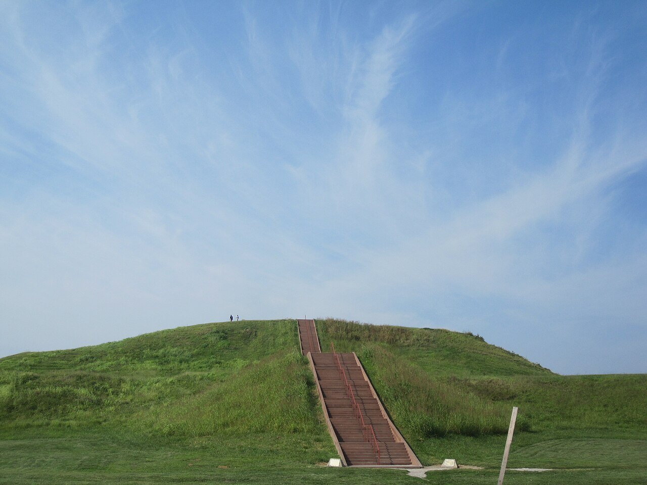
At its height around 1100 CE, Cahokia was the largest city in North America north of Mexico, with an estimated population of 10,000 to 20,000 people — a figure not exceeded by any North American city until Philadelphia reached similar numbers in the 1780s. Built entirely from hand-carried earth by the Mississippian culture over a period of three centuries, the site’s central mound has a larger base footprint than the Great Pyramid of Giza. Cahokia received UNESCO World Heritage designation in 1982 and remains among the most significant and least-visited major heritage sites in the United States.
The Mississippian city and Monks Mound Collinsville, Illinois, 24 km east of St. Louis
The people who built Cahokia are identified by archaeologists as the Mississippian culture — a collective term for a series of Native American agricultural societies that flourished in the river valleys of the central and southeastern United States from approximately 800 CE to 1600 CE. The Mississippians were not a single tribe or nation with a unified political structure but a cultural tradition defined by shared architectural practices (the construction of flat-topped earthen mounds for civic and ceremonial use), shared economic patterns (intensive maize agriculture in river floodplains), and shared artistic conventions (a complex symbolic system of imagery involving birds of prey, sun symbols, warrior figures and cosmic serpents, known to archaeologists as the Southeastern Ceremonial Complex). They were entirely distinct from, and centuries earlier than, the Aztec, Maya or Inca civilisations further south. No written records survive from Cahokia; no contemporary account of the city exists. Everything known about it comes from archaeology.
Cahokia, situated in the fertile American Bottom floodplain where the Missouri River joins the Mississippi just east of modern St. Louis, grew from a small agricultural village around 700 CE into a major urban centre with extraordinary speed. The rapid population increase after approximately 1050 CE — sometimes called the “Big Bang” of Cahokia by archaeologists — may have been triggered by a combination of agricultural surplus (the floodplain soils were exceptionally productive), the emergence of a charismatic political and religious leadership, and the attraction of trade networks connecting the Great Lakes, the Gulf Coast and the Rocky Mountain region. At its greatest extent, Cahokia covered 16 square kilometres and contained more than 200 earthen mounds of three distinct types: flat-topped platform mounds that served as bases for elite residences, temples or charnel houses; conical burial mounds; and ridge-top mortuary mounds defining the boundaries of ceremonial districts.
Monks Mound, the central and largest structure, is the defining monument of Cahokia and the largest earthwork in the pre-Columbian Americas. It rises 30 metres above the surrounding plain — roughly the height of a ten-storey building — and measures 290 metres by 255 metres at its base, a footprint that exceeds that of the Great Pyramid of Giza (which measures approximately 230 metres per side). The mound was built in stages over approximately 300 years, from roughly 900 to 1200 CE, using an estimated 22 million cubic feet of soil transported entirely in human-carried baskets from borrow pits in the surrounding area. The labour organisation required to achieve this — coordinating thousands of workers across multiple generations without draft animals, wheeled vehicles or metal tools — implies a degree of social stratification and political authority comparable to that of the early state societies of the Old World.
On the summit of Monks Mound stood a large wooden structure approximately 30 metres long and 15 metres wide, identified by post-hole patterns in the archaeological record as almost certainly the residence or throne room of Cahokia’s paramount chief. The chief’s elevation above the city was both practical (commanding views in all directions) and symbolic (the mound physically embodied the social distance between ruler and ruled). A grand staircase on the south face connected the summit to the lower terraces and, ultimately, to the Grand Plaza below — a rectangular open space of roughly 19 hectares immediately south of Monks Mound that served as the civic and ceremonial heart of the city.
Woodhenge, the Beaded Burial and the city’s abandonment Within the Cahokia site complex, Illinois
To the west of Monks Mound, archaeologists have identified and partially reconstructed a series of large circles made from wooden posts, which have been given the name Woodhenge by analogy with the famous British monument — though the Cahokia structures are entirely independent in origin and considerably younger. At least five successive circles were built at the site over a period of approximately 200 years, each slightly different in size and layout. The posts were made from large cedar logs, some up to 45 centimetres in diameter, set into prepared pits. The circles range from 75 to 130 metres in diameter and each contained between 24 and 72 posts. The four cardinal posts in each circle align with the rising of the sun at the winter and summer solstices and the spring and autumn equinoxes, indicating that Woodhenge served as a solar calendar, allowing priests or astronomers to fix the ritual calendar with precision. The reconstructed circle visible at the site today is based on the fourth iteration of the structure, dated to approximately 1100 CE.
Among the most archaeologically significant discoveries at Cahokia is Mound 72, a small ridge-top mound about 900 metres south of Monks Mound excavated in the 1960s. Beneath this apparently modest earthwork, archaeologists discovered an extraordinarily rich burial assemblage that has become central to understanding the political and religious ideology of the Cahokia elite. The primary burial — a male individual, probably a paramount chief — was laid on a bed of approximately 20,000 marine shell beads arranged in the shape of a falcon with outspread wings. Surrounding him were caches of mica, copper, chunkey stones (used in a game central to Mississippian social life), and projectile points from distant regions, testifying to the city’s trade connections. In the same mound, beneath the primary burial and in adjacent pits, lay the remains of 272 additional individuals, including at least 52 young women of similar age whose skeletal remains show no signs of disease or nutritional stress — indicating they were healthy individuals who were sacrificed at the time of the primary burial. The shell-bead falcon burial is interpreted as evidence that Cahokia’s paramount chief claimed an identity as the Birdman, a supernatural being in Mississippian mythology who mediated between the human world and the upper cosmic realm.
Cahokia was largely abandoned by 1350 CE, approximately 200 years before any European contact with North America. The reasons remain actively debated among archaeologists. Environmental evidence points to a major flood of the American Bottom around 1150 CE, followed by a prolonged drought in the 13th century that would have severely stressed the maize agriculture on which the city depended. Political fragmentation — the breakdown of the centralised authority that had held the city together — may have accompanied or accelerated the agricultural crisis. The abandonment was probably gradual rather than sudden, with the population dispersing to smaller agricultural settlements throughout the region. By the time French explorers first recorded the mounds in the late 17th century, the structures had been completely forgotten by the local Native American groups, who had no oral traditions connecting them to Cahokia. Of the original 200+ mounds, only about 80 survive today; the others were leveled for farming in the 19th century or absorbed by the expanding suburbs of the St. Louis metropolitan area.
Practical information
Cahokia Mounds State Historic Site is located in Collinsville, Illinois, approximately 24 kilometres east of downtown St. Louis, Missouri. By car from St. Louis, cross the Mississippi on Interstate 55/70 and follow signs to the site; the drive takes about 25 minutes. There is no convenient public transport from St. Louis; a taxi or rideshare is the practical option for visitors without a car. The site is free to enter, though a donation is requested. The interpretive centre — an excellent facility with dioramas, artefact displays and an orientation film — is open Wednesday through Sunday from 9:00 AM to 5:00 PM; hours may change seasonally, so confirm before visiting. Monks Mound itself is accessible via a stepped path and is open during daylight hours; the climb to the summit takes about 10 minutes and offers panoramic views across the floodplain toward the St. Louis skyline.
The best time to visit is spring or autumn, when temperatures are moderate and the prairie landscape around the mounds is at its most atmospheric. Summer days can be hot and humid; winter visits are possible but the interpretive centre has reduced hours. Allow at least half a day: an hour for the interpretive centre, an hour to climb Monks Mound and walk the Grand Plaza, and additional time if you wish to visit Woodhenge (a short drive or 20-minute walk from the main area). Binoculars are useful for scanning the landscape from the mound summit. The site is surrounded by the sprawl of the St. Louis metropolitan area, which requires a degree of imaginative reconstruction, but the mounds themselves are impressive enough to make the setting secondary.
Frequently Asked Questions
Why is Cahokia so little known compared to other UNESCO World Heritage Sites?
Cahokia’s relative obscurity is a function of several converging factors. First, the site produces no immediately legible architecture: there are no stone temples, decorated facades, statues or inscriptions that provide a visual shorthand for a sophisticated civilisation. Earthen mounds, however impressive in scale, require significant background knowledge to appreciate — the visitor arriving without context sees large grassy hills rather than the remarkable feat of organised labour and civic planning that they represent. Second, the site sits in an unscenic suburban environment between a major highway and a municipal airport, which does not help first impressions. Third, the complete absence of written records or a surviving cultural tradition connecting modern Native American groups to Cahokia means there is no living community to advocate for the site or to provide the kind of cultural continuity that makes places like Mesa Verde or Canyon de Chelly more legible to American visitors. Fourth, and most broadly, the popular understanding of pre-Columbian North America north of Mexico tends to be shaped by 19th-century ideas about “primitive” hunter-gatherers that the very existence of Cahokia refutes. A city of 10,000 to 20,000 people with a planned layout, a solar calendar, long-distance trade networks and monumental architecture built without metal tools or wheels does not fit the common narrative, and educational systems have been slow to incorporate this revised understanding. The UNESCO inscription in 1982 was precisely intended to raise the site’s international profile, and recent years have seen increased scholarly and popular attention to Cahokia as an essential chapter in North American history.
Who were the Mississippians, and are they ancestors of any modern Native American nations?
The Mississippian culture is an archaeological designation for a set of cultural practices, not a single ethnic or political group. The people who built Cahokia and dozens of smaller Mississippian centres across the central and southeastern United States were the ancestors of multiple modern Native American nations, though the specific ancestral connections between Cahokia and any particular contemporary group are not definitively established. Candidates proposed by archaeologists and by tribal oral traditions include the Osage, Quapaw, Ponca, Omaha, and other Siouan-speaking peoples, as well as the ancestors of the Choctaw, Chickasaw and other Muskogean groups further south. The difficulty is that the collapse of Cahokia and the dispersal of its population around 1350 CE — followed by European contact, epidemic disease and forced relocation over the next 400 years — created a long gap in cultural continuity that is hard to bridge with the available evidence. Some tribal nations have made formal claims of cultural affiliation with Cahokia under the Native American Graves Protection and Repatriation Act (NAGPRA), which governs the treatment of human remains and sacred objects from the site. The Illinois State Museum, which manages the archaeological collections from Cahokia, works with tribal representatives on these questions. The current scholarly consensus is that multiple modern nations likely share ancestry with Cahokia’s inhabitants, and that no single group has an exclusive claim.
What is the chunkey game, and why was it important at Cahokia?
Chunkey was a game that functioned as one of the central social and political institutions of Mississippian culture. The equipment was simple: a stone disc, typically 5–10 centimetres in diameter and carefully ground to a precise biconvex shape, and two long wooden poles. Players threw the stone disc along a prepared clay surface and then threw or slid their poles to land as close as possible to where the disc would stop — a combination of physical skill, prediction and gambling. What made chunkey politically significant was the betting: players wagered personal possessions, social status and, in some accounts, their own freedom on the outcome. A skilled chunkey player who consistently won could accumulate followers, status and material wealth. The paramount chief at Cahokia almost certainly controlled access to the finest chunkey stones, which were among the most valued portable prestige objects in Mississippian society. The caches of chunkey stones found in the elite burials at Mound 72 suggest they were treated as objects of political and spiritual power, not just gaming equipment. The game spread with Mississippian cultural influence across a wide geographic area, and variants of it were still being played by southeastern Native American nations when European observers first recorded it in the 18th century. Chunkey is one of the clearest examples of how material culture from Cahokia can be traced in the lifeways of modern Native American communities, providing a thread of continuity across the gap created by the city’s abandonment and the disruptions of European colonisation.


