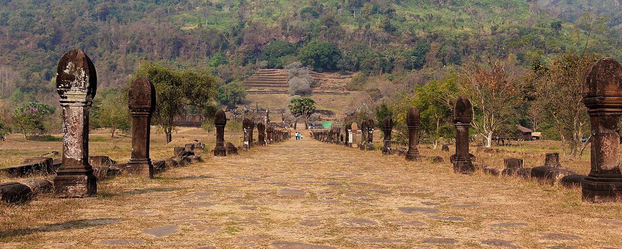
Vat Phou predates Angkor Wat by several centuries and occupies a site that has been considered sacred since at least the 5th century CE — long before the stones of its current sanctuary were cut. The complex climbs the southern slopes of Phou Kao mountain in what is now Champasak Province, southern Laos, organised on a strict ceremonial axis that runs from the Mekong River, six kilometres to the west, through two large reservoirs, across a causeway, through two elaborate pavilions and up a series of stone staircases to the main sandstone sanctuary. The UNESCO inscription, granted in 2001, covers not just the temple but the entire associated cultural landscape including the ruins of a city that may have been the capital of one of the Khmer predecessor states.
The sacred mountain and the pre-Angkorian Khmer complex Champasak Province, southern Laos, 40 km south of Pakse
The mountain behind the Vat Phou sanctuary is called Phou Kao, meaning “mountain of the lingam” in Lao — a name that reflects the religious logic that made this location sacred long before the current temple was built. The mountain’s rocky summit, when seen from the floodplain of the Mekong to the west, has a profile that was interpreted in Hindu theology as resembling a lingam, the phallic symbol of the god Shiva. In the Shaivite tradition (the branch of Hinduism devoted to Shiva) that dominated the Khmer kingdoms from at least the 5th century CE, natural landscape features of exceptional character — unusual mountains, springs with pure water, river confluences — were understood as manifestations of divine presence. Phou Kao possessed two such features: the evocative profile and a natural spring that emerged from the rock face just above the main sanctuary. This spring water, directed through channels cut in the rock and through the sanctuary itself, was used for ritual ablutions and to anoint the principal Shiva lingam housed in the shrine’s inner sanctum. The sanctity of the water — flowing from the mountain through the shrine and out toward the Mekong — encoded a theology of cosmic fertility and divine kingship in the very hydrology of the site.
The earliest archaeological evidence of occupation at Vat Phou dates to the 5th and 6th centuries CE, during what is now called the Funan and early Chenla periods — the Khmer predecessor states that occupied the lower Mekong valley before the rise of the Angkor Empire. These early polities were kingdoms of the floodplain and estuary, enriched by trade between India and China, and thoroughly Indianised in their court culture, religious practices and political ideology. The 6th-century ruler Citrasena-Mahendravarman, known from several inscriptions found in the Champasak region, is recorded as having developed the Vat Phou sanctuary, and the town at the base of the mountain — now known in the archaeological literature as Lingapura or Shrestapura — may have served as his capital. The name Lingapura means “city of the lingam,” directly connecting the settlement to the sacred character of the mountain above it.
The architectural development of Vat Phou’s present structures occurred primarily between the 10th and 13th centuries CE, when the region was under the direct control of the Khmer Empire of Angkor. Khmer rulers of the Angkor period invested heavily in building and rebuilding sacred sites throughout their empire, and Vat Phou was consistently treated as one of the most important — it appears in inscriptions from Angkor as a major religious centre receiving royal donations of land, servants and sacred objects. The sandstone of the current sanctuary, the carved lintels and pediments, the stone causeways and the elaborate two-storey pavilions at the lower terrace all date from this period of Angkorian patronage. The site uses the same constructional principles as Angkor Wat itself (completed approximately 1150 CE): dry-laid sandstone blocks of extraordinary precision, corbelled vaults, and lintels carved with scenes from Hindu mythology.
The Churning of the Ocean of Milk — the foundational myth of Shaivite and Vaishnavite Hindu cosmology, in which gods and demons cooperate to churn the primordial ocean using the serpent Vasuki wrapped around Mount Mandara, extracting amrita (the nectar of immortality) — is depicted on the lintel above the main entrance to the sanctuary. Vishnu Reclining on the Serpent Ananta appears on other decorative panels. These scenes, executed with the same iconographic precision as comparable carvings at Angkor, indicate that the craftsmen working at Vat Phou were trained in the full canon of Angkorian artistic conventions.
The ceremonial landscape, Buddhist continuity and the Makha Bucha festival From the Mekong bank to the summit sanctuary, Champasak
What distinguishes Vat Phou from most other Khmer sites — and from Angkor Wat in particular — is that its full significance only becomes apparent when understood as a landscape rather than as an individual building. The UNESCO inscription is formally titled “Vat Phou and Associated Ancient Settlements within the Champasak Cultural Landscape,” and this phrasing captures the essential point: the temple complex cannot be separated from its setting within a 390 km² zone that includes the Mekong River, the sacred mountain, the reservoirs, the ancient city at the base of the hill, and the ceremonial causeway connecting all these elements into a single unified design.
The ceremonial axis begins at the Mekong’s eastern bank, six kilometres to the west of the main temple. From there, a processional way (only partially visible today) led to the entrance of the sacred precinct, passing between two large rectangular reservoirs called baray — artificial bodies of water that served both practical purposes (irrigation, fish cultivation) and symbolic ones (representing the cosmic ocean surrounding the sacred mountain at the centre of the universe, in standard Khmer cosmographic thinking). The baray at Vat Phou, each approximately 200 by 600 metres, are still filled with water and reflect the mountain and temple in conditions of still air. Beyond the baray, the processional way continues to the lower terrace, dominated by two large stone pavilions. These two-storey structures, one on the north side of the axis and one on the south, have corbelled roofs with elaborate carved facades; their interiors were probably used for receiving pilgrims, storing ceremonial objects and housing temple servants. The attribution of one pavilion to female pilgrims and the other to male pilgrims, sometimes stated in tourist literature, is not confirmed by archaeological evidence.
From the lower terrace, a stone staircase of approximately 70 steps ascends to the middle terrace, then a further staircase to the upper terrace where the main sanctuary stands directly against the mountainside, its rear wall incorporating the natural rock face. The spring above the sanctuary has been directing water over and around this rear wall and through the shrine since antiquity; the constant moisture has contributed both to the weathering of the stone and to the thick moss and tropical vegetation that gives the upper sanctuary its distinctive atmosphere of deep time and organic overgrowth.
Vat Phou today functions as an active Buddhist temple, not a Hindu one — the name “Vat Phou” means “mountain temple” or “mountain monastery” in Lao, using the Lao word for Buddhist temple (vat, cognate with Thai and Khmer wat). The transition from Hindu to Buddhist use followed the broader religious shift of mainland Southeast Asia in the 12th and 13th centuries CE. The main sanctuary now houses Buddhist images alongside traces of the earlier Hindu programme. The most important contemporary use is the annual Makha Bucha festival (also called Boun Wat Phou), held on the full moon of the third lunar month, typically in February. Tens of thousands of pilgrims from across Laos and from neighbouring Thailand, Cambodia and Vietnam travel to Vat Phou for this three-day festival, which combines religious observances at the temple with a large fair, elephant shows and folk performances in the lower terrace area. For heritage visitors, the festival period offers extraordinary atmosphere but requires advance accommodation booking in Champasak town and Pakse.
Practical information
Vat Phou is situated 40 kilometres south of Pakse, the main city of southern Laos and the regional transport hub. The easiest approach from Pakse is by tuk-tuk or hired car along Route 13 south to the ferry crossing at Champasak town, then a short ride to the site entrance. The journey takes approximately one hour. Champasak town itself has guesthouses and small restaurants and is a pleasant base; most visitors also cross to the town from Pakse by slow boat along the Mekong, a scenic journey of two to three hours. The site entry fee is payable in Lao kip at the gate; a small additional fee covers access by vehicle along the approach road. The site opens at 8:00 AM and closes at 5:00 PM daily.
The best time to visit is November to February, the dry season in southern Laos, when heat and humidity are manageable and the mountain behind the sanctuary is sometimes shrouded in morning mist. March to May is hot and increasingly dry but still manageable in the early morning hours. June to October brings the monsoon, which makes the staircases slippery and the lower terraces muddy but also fills the baray to capacity and gives the vegetation its most lush appearance. The Makha Bucha festival in February draws large crowds; if this is your goal, book accommodation two to three weeks in advance. Walking the full ceremonial axis from the lower terrace to the upper sanctuary takes about 90 minutes at a moderate pace allowing time at each level. The site has a small museum near the entrance with artefacts from excavations and informative panels on the history of the Champasak cultural landscape.
Frequently Asked Questions
How does Vat Phou compare to Angkor Wat, and is it worth visiting if you have already been to Angkor?
Vat Phou and Angkor Wat share an artistic and architectural tradition — both are products of Khmer civilisation, both were built as expressions of Hindu kingship ideology using sandstone quarried and dressed by highly trained craftsmen, and both follow cosmographic plans encoding the structure of the universe in their layout. But the experience of visiting them is fundamentally different in ways that make Vat Phou valuable precisely for those who have already seen Angkor. Angkor is now visited by more than two million tourists per year, which makes the logistical experience of the site — crowds at sunrise, ticket queues, tuk-tuk convoys — inescapable. Vat Phou receives a fraction of that number and retains an atmosphere of relative quiet and genuine remoteness. The site is also less restored: the vegetation that climbs the upper sanctuary walls and the weathering of the stone create a reading of the monument as a natural and historical phenomenon rather than a conserved museum piece. More substantively, Vat Phou illuminates the origins of the Khmer tradition that produced Angkor: it is a living example of the pre-Angkorian sacred site type from which the later great temples developed. Seeing Vat Phou helps explain why Angkor Wat looks the way it does — the cosmographic axis, the baray, the mountain identification, the spring ablution — because these features appear at Vat Phou in their early, still partially legible form before they were elaborated into the vast complexity of the Angkor complex. For a heritage traveller with a serious interest in Khmer civilisation, Vat Phou is not a lesser alternative to Angkor but a complementary chapter in the same story.
What is the Champasak Cultural Landscape, and what sites does it include beyond the temple complex?
The UNESCO World Heritage designation covers a 390 km² zone formally defined as the Champasak Cultural Landscape, which extends well beyond the visible temple complex on the hillside. The second major component of the inscription is the ruined city known to archaeologists as Lingapura or Shrestapura, located at the base of Phou Kao mountain near the river. Archaeological survey of this area has identified traces of a substantial settlement including the remains of brick-built structures, water management features and material culture consistent with a 5th–7th century CE urban centre. If the identification of this site as the capital of the Chenla kingdom is correct (and this identification is strongly suggested by epigraphic evidence — inscriptions mentioning the city — rather than confirmed by comprehensive excavation), then Lingapura was one of the most politically significant sites in pre-Angkorian Southeast Asia. The broader cultural landscape also encompasses the two large baray west of the temple, the processional way linking the Mekong bank to the temple precinct, and a number of smaller archaeological features in the surrounding fields and riverbanks. Systematic archaeological work in the cultural landscape has been conducted by Laotian authorities in collaboration with French and Italian research teams since the 1990s. Visitors with a strong archaeological interest can explore the Lingapura area with a local guide, though there are no formal visitor facilities or marked trails; the terrain is agricultural land with isolated structural remains emerging from rice fields and secondary vegetation.
What is the religious significance of the spring at the summit of Vat Phou, and is it still venerated today?
The spring at the summit of Phou Kao, just above the rear wall of the main sanctuary, is the single most important reason for the entire complex’s existence. In Shaivite Hindu theology, pure water emerging from a mountain summit was understood as liquid evidence of divine presence — the mountain was the abode of Shiva, and the spring was Shiva’s grace flowing from his body to the world below. The architectural design of the Vat Phou complex was organised from the outset to channel this water: channels cut into the rock face above the sanctuary direct the spring water over a Shiva lingam (the sacred phallic stone symbolising the god’s creative power) housed in the inner sanctum, and from there through stone conduits that once led the ritually charged water down the hillside toward the baray and ultimately toward the Mekong. The ablution of the lingam with mountain spring water was one of the central daily rituals of the temple’s Hindu period. The spring continues to flow, and the site continues to be venerated — now in a Buddhist rather than Hindu framework. Lao Buddhist pilgrims who climb to the upper sanctuary often collect water from the spring for use in ritual offerings and for drinking, treating it as holy water in a manner that is functionally continuous with, though theologically distinct from, the original Hindu practice. The spring is accessible via a short steep path behind the main sanctuary and is worth visiting both for its religious atmosphere and for the view it provides of the summit rock formations.