At 3,850 metres above sea level on the Bolivian altiplano, Tiwanaku was the political and spiritual capital of the most influential civilisation in the Andes before the rise of the Inca. Flourishing between roughly 500 and 1000 CE, the city at its height controlled a sphere of influence reaching across modern Bolivia, Peru and northern Chile, shaping religious iconography, agricultural technique and political organisation across a vast territory. UNESCO inscribed it as a World Heritage Site in 2000.
The city on the roof of the world 72 km from La Paz, near the southern shore of Lake Titicaca
Tiwanaku occupies a position unique among ancient urban centres: a capital city built on a high-altitude plain where the air is thin, temperatures drop sharply at night and the growing season is short. That such a metropolis could sustain a population estimated at between 10,000 and 40,000 within the city itself — and exert cultural and political authority over up to one million people across its wider sphere — is a measure of the sophistication of Tiwanaku’s agricultural engineers. They developed raised-field farming systems, known as suka kollus, in the shallow lake margins around Lake Titicaca: elevated earthen platforms separated by water channels that absorbed solar heat during the day and released it at night, protecting crops from frost. When agronomists in the 1980s reconstructed these systems experimentally, yields outperformed modern chemical-fertiliser farming in the same environment.
The city was oriented with precision on the cardinal directions and organised around a series of monumental ceremonial complexes. The most visible surviving structure is the Akapana pyramid — 17 metres tall, with seven tiered terraces and a base measuring roughly 200 metres on each side. For centuries it was assumed to be a natural hill that had been partially modified. Only detailed archaeological investigation confirmed that it is entirely man-made, built in stages over several centuries from the city’s founding. Water channels cut through the Akapana’s terraces in a deliberate pattern, possibly to create dramatic cascading effects during festivals or to symbolise the sacred mountain and its rivers.
The Kalasasaya is the second major ceremonial complex: a large raised platform approximately 126 by 117 metres, originally surrounded by standing stones (kalasas) set into the earth at intervals. Much of what visitors see today reflects early 20th-century reconstruction that is not always accurate to the original layout, but the platform itself is genuine. Inside the Kalasasaya stands the Ponce Monolith — a 3-metre sandstone anthropomorphic figure with elaborate carved headdress and belt, holding ritual vessels. It is one of several such monoliths from Tiwanaku now distributed between the site and the National Museum of Archaeology in La Paz.
The Semi-Subterranean Temple — a rectangular sunken court measuring roughly 28 by 26 metres — is among the most visually striking features of the site. Its interior walls are studded with stone heads carved in relief and set directly into the masonry. These heads vary in physiognomy and are now interpreted as representing peoples from across Tiwanaku’s sphere of influence — a visual statement of imperial reach rather than the trophy heads once proposed. The sunken courtyard’s design, with its entry steps and surrounding terraces, was replicated in ceremonial spaces across the Tiwanaku world.
The Gate of the Sun and the collapse of a civilisation Altiplano, Bolivia — Lake Titicaca region
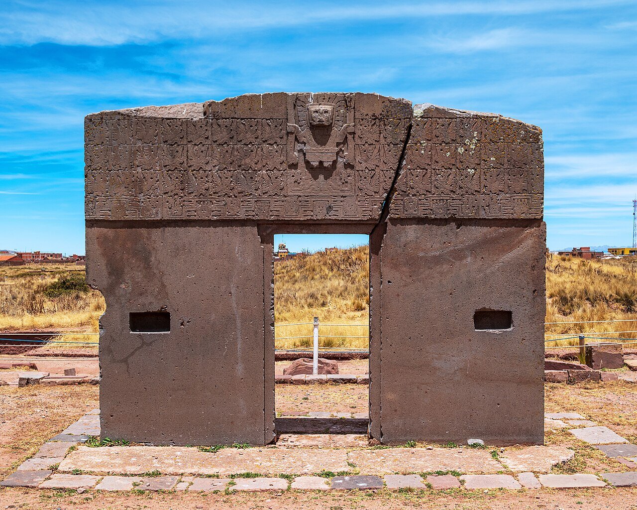
No object from Tiwanaku has attracted more sustained scholarly attention than the Gate of the Sun, a monolithic doorway carved from a single block of andesite weighing approximately 10 tonnes and measuring three metres tall by four metres wide. It was found by European explorers in the 19th century lying toppled and cracked — the crack running vertically through the lintel relief. How and when it fell is unknown; earthquake damage and deliberate vandalism by Spanish colonists or earlier opponents of the Tiwanaku state have both been proposed.
The relief carved above the doorway is among the most studied images in Andean archaeology. At its centre stands the Staff God — a frontal anthropomorphic deity with a solar crown from which rays terminate in condor heads, carrying a staff in each hand topped with condor figures, and with a band of circles around his belt. Tears fall from his eyes in the form of small geometric figures. This deity, identified with the creator god Viracocha (also called Wiracocha or Tunupa depending on regional tradition), appears across the Tiwanaku artistic sphere from coastal Peru to the Chilean Atacama, in textiles, ceramics and stone carvings, suggesting a coherent religious system that transcended the city itself. Flanking the central figure are 48 smaller running winged beings arranged in two rows of 24 — possibly attendants, messengers or subsidiary deities.
The Tiwanaku civilisation collapsed around 1000 CE. Palaeoclimatic research has produced strong evidence that an extended drought lasting several decades reduced the water levels in Lake Titicaca and dried the wetlands where the raised-field agricultural systems operated. Without the lake margin farming that fed the city, the population dispersed. The physical infrastructure — pyramids, temples, monoliths — was partly dismantled in later centuries, with stonework reused in colonial-era construction in the nearby town of Tiwanaku and as far away as La Paz.
The Inca, who rose to regional dominance in the 15th century, were well aware of Tiwanaku’s legacy. Inca oral tradition identified Tiwanaku as the place where the creator god Viracocha made the first human beings from stone and commanded them to spread across the earth. By claiming continuity with Tiwanaku — and by incorporating Tiwanaku iconography and mythology into their own state religion — the Inca legitimised their authority across the former Tiwanaku sphere. It is one of the clearest examples in the ancient Americas of deliberate ideological inheritance.
Practical information
Tiwanaku is 72 kilometres west of La Paz on the road to the Peruvian border at Desaguadero; minibuses depart from the cemetery district (cementerio) of La Paz throughout the morning and the journey takes approximately 90 minutes to two hours depending on traffic. A guided day tour from La Paz is the most common option and includes the site museum, where the best-preserved monoliths are housed. The altitude is considerable — 3,850 metres — and visitors arriving directly from low-altitude cities should allow a minimum of 24 hours of acclimatisation in La Paz (itself at 3,600 metres) before exerting themselves. The dry season (May to October) is the recommended visiting period; the wet season (November to April) brings regular rain that can make unpaved sections of the site muddy. Entry includes access to both the archaeological site and the on-site museum. A half-day is sufficient for a focused visit; a full day allows time for both the site and the museum in La Paz. Bring sun protection — UV radiation at altitude is significantly higher than at sea level, and the altiplano sky is typically cloudless in the dry season.
Frequently Asked Questions
Who built Tiwanaku and where did they come from?
The builders of Tiwanaku are referred to by modern scholars simply as the Tiwanaku people or the Tiwanaku civilisation — no contemporary written records survive that give the city’s own inhabitants a name for themselves or their polity, and the name Tiwanaku itself derives from an Aymara term recorded in the colonial period. Archaeological evidence suggests that the site was first occupied as a village around 1500 BCE, but the monumental phase of construction that produced the pyramids, temple platforms and sculpted stone gateways began around 200 CE and intensified through the 5th and 6th centuries. The population of the wider Tiwanaku region in the centuries before the city’s emergence was Aymara-speaking, and the present-day Aymara communities of the Bolivian altiplano are generally regarded as the cultural descendants of the Tiwanaku civilisation. The Tiwanaku state appears to have been a theocratic polity in which religious authority and political power were tightly integrated — the monumental ceremonial centre at the city’s core served both as a seat of government and as the principal ritual landscape for the wider empire. Expansion of Tiwanaku’s sphere of influence seems to have occurred primarily through ideological means — the spread of the Staff God religious complex, shared architectural forms and agricultural technology — rather than through military conquest alone, though the extent to which Tiwanaku expansion was coercive or voluntary remains debated among Andean specialists.
What happened to the Gate of the Sun — why was it found cracked and lying on its side?
The Gate of the Sun was found in 1877 by Ephraim George Squier, an American diplomat and self-taught archaeologist, lying face-up on the ground with a vertical crack running through the carved lintel. The crack passes directly through the Staff God relief and is clearly visible today even after the monument was re-erected. The reason it fell and the reason it cracked are separate questions. The most plausible explanation for the crack is that the enormous stone — approximately 10 tonnes carved from a single andesite block — was not positioned on sufficiently stable ground and eventually fractured under its own weight when it was no longer supported correctly. The reasons for its displacement are more contested. Spanish colonial-era destruction of pre-Christian religious monuments is one possibility: the Gate would have been an obvious target for missionaries intent on eliminating indigenous religious sites. Earthquake damage is another; the altiplano experiences significant seismic activity. Some scholars propose that the displacement occurred much earlier — that the Gate was moved or overthrown during the political collapse of the Tiwanaku state around 1000 CE, perhaps as a deliberate act of desecration by rival groups. The Gate was re-erected in its present position in the 20th century, though its original location within the Kalasasaya complex — and whether the current position is accurate — remains a matter of scholarly discussion.
How was Tiwanaku able to sustain a large city at such high altitude?
Sustaining a urban population of 10,000 to 40,000 people at nearly 4,000 metres above sea level, in a climate with hard frosts, thin soils and a short growing season, required agricultural innovation of a high order. The key technology was the raised-field system — known in the Aymara language as suka kollus — in which long platforms of earth were built up from the lakebed margins of Lake Titicaca, separated by channels of standing water. The channels performed several functions simultaneously: they irrigated the raised beds, they supported aquatic plants and fish that contributed additional food and organic matter for compost, and crucially they acted as thermal regulators. Water has a higher heat capacity than soil or air, so the channels absorbed solar radiation during the day and released it slowly at night, creating a microclimate above the raised beds that was several degrees warmer than the surrounding altiplano — enough to extend the growing season and protect against the frost that would otherwise destroy crops. When Peruvian and Bolivian agronomists reconstructed these raised fields experimentally in the 1980s and 1990s, yields of potatoes and quinoa consistently matched or exceeded those achieved with modern chemical inputs on conventional fields in the same environment. The Tiwanaku economy also relied heavily on camelid herding (llamas and alpacas for meat, wool and as pack animals), and on an extensive exchange network that brought dried fish from Lake Titicaca, marine products from the Pacific coast and tropical forest goods from the eastern Andean slopes into the city.