
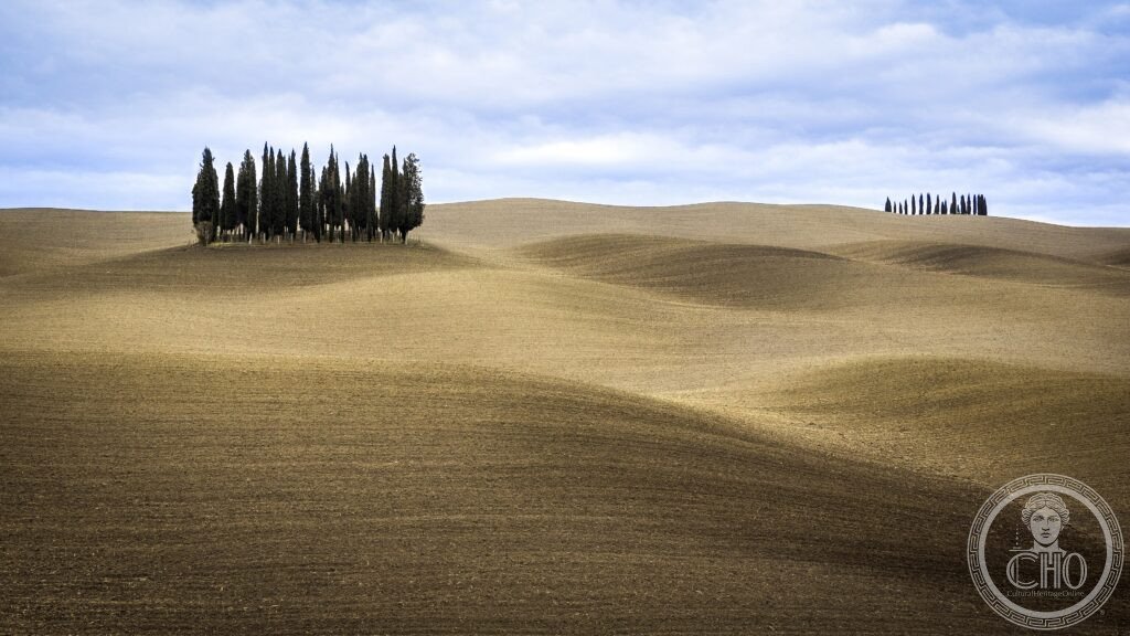
Grey clay hills lined with cypress windbreaks, hilltop farmhouses and medieval towns make up a landscape that Sienese painters of the fourteenth century used as the ideal backdrop to their altarpieces. Shaped by centuries of agricultural planning, it remains one of the most recognisable rural landscapes in Italy.
At a glance
The Val d’Orcia takes its name from the Orcia river, which rises on Monte Amiata and flows northeast to join the Ombrone near Buonconvento. The valley floor, once prone to flooding and malaria, was left largely unsettled, while towns and farmhouses were built on the surrounding ridges at moderate altitude. The pale, almost bare hills known as the crete senesi are formed from marine clay and sand laid down when the area lay under a shallow arm of the Tyrrhenian Sea; the alkaline soil supports little beyond grass, which gives the landscape its distinctive colour.
What turns this geology into the image now associated with Tuscany is a layer of human intervention: lines of Italian cypress planted from the fifteenth to seventeenth centuries as windbreaks along field boundaries, isolated farmhouses called poderi built under the mezzadria sharecropping system, and a scatter of walled hilltop towns linked historically by the Via Francigena pilgrim route.
Key facts
- Location: Province of Siena, Tuscany, along the Orcia river valley.
- Main towns: Pienza, Montalcino, San Quirico d’Orcia, Castiglione d’Orcia and Radicofani.
- Landscape features: cypress windbreak lines, hilltop poderi, crete senesi clay hills.
- Heritage status: inscribed as a UNESCO World Heritage Site in 2004, reference 1026.
- Wine: Montalcino produces Brunello di Montalcino DOCG, made from the Sangiovese Grosso clone.
- Pilgrim route: the Via Francigena crosses the valley between San Quirico d’Orcia and Radicofani.
History
From the twelfth to the sixteenth century the Val d’Orcia formed the southern territory of the Sienese Republic, which built hospitals for pilgrims along the Via Francigena, bridges such as the Ponte d’Arbia and Ponte Rotto, and fortified farms across the countryside. One of the most significant of these survives at Bagno Vignoni, where a travertine-lined thermal pool once served travellers on the pilgrim road.
The Piccolomini family, among the valley’s leading noble houses, produced two popes: Pius II, born Enea Silvio Piccolomini, and his nephew Pius III, whose reign lasted only weeks. Pius II’s transformation of his birthplace, Corsignano, into the planned Renaissance town of Pienza stands as the clearest architectural mark left on the valley by this family.
Montalcino developed as the valley’s wine centre. Ferruccio Biondi Santi is credited with selecting the Brunello clone of Sangiovese and producing the first Brunello Riserva in the late nineteenth century, laying the foundation for the DOCG wine now associated with the town. The Val d’Orcia was inscribed on the UNESCO World Heritage list in 2004, under reference 1026, in recognition of this combination of natural landscape and centuries of agricultural design.
What you see
Pienza’s central square, the Piazza Pio II, was designed by the Florentine architect Bernardo Rossellino as a single composition of four different buildings around one space: the cathedral, the Palazzo Piccolomini, the Palazzo Vescovile and the Palazzo Comunale. The cathedral façade uses a deliberate perspective trick, with columns set wider at the front than the back to exaggerate depth from the piazza. Its choir end, built on a steep slope with inadequate foundations, has cracked repeatedly since shortly after completion, a fault Pius II himself noted in his memoirs, the Commentarii.
Beyond the town, the classic view of the valley opens along the road between San Quirico d’Orcia and Pienza, where a line of cypress trees runs beside rolling white clay hills, a composition endlessly reproduced in photographs of Tuscany. From the terrace of the Fortezza di Montalcino, the panorama takes in Monte Amiata, Siena and the whole Val d’Orcia. At Bagno Vignoni, the medieval thermal pool still occupies the centre of the small hamlet, though bathing in the historic basin has long been prohibited.
Practical information
- Visiting the landscape: the valley is best explored slowly, by car or on foot, with stops in Pienza, Montalcino and Bagno Vignoni.
- Walking the Via Francigena: the stretch between San Quirico d’Orcia and Radicofani is considered one of the most scenic day walks in central Italy.
- Accommodation: many of the historic poderi now operate as agriturismo, offering a base within the landscape itself.
- Admission and opening times: for current access to the Fortezza di Montalcino and other sites, check the relevant official channels before visiting.
Getting there
The Val d’Orcia lies within the Province of Siena, reached along the SP146 road, which runs through the classic cypress-lined countryside between San Quirico d’Orcia and Pienza. Montalcino, San Quirico, Castiglione d’Orcia and Radicofani are all within the same stretch of valley, making a car the most practical way to link them.
Nearby
- Montalcino — hilltop town and centre of Brunello di Montalcino wine production.
- San Quirico d’Orcia — starting point for the scenic Via Francigena walk to Radicofani.
- Castiglione d’Orcia — one of the valley’s hilltop towns overlooking the Orcia.
- Bagno Vignoni — small hamlet built around a medieval thermal pool once used by pilgrims.
Sources
- UNESCO
- Pius II, Commentarii
Find it on the map
See this place and what’s around it →📷 Become a Cultural Heritage Online photographer
Share your photos of places: they stay published under your name as the author. The more they're seen, the more you get noticed — and soon a contest will reward the most appreciated photos.
Log in or sign up free to add a photo