
Uxmal is the clearest surviving expression of Puuc Maya architecture, its buildings faced in fitted mosaic stone rather than carved relief. The Governor’s Palace, over a hundred metres long and studded with more than a hundred and fifty masks of the rain god Chaac, was the building that convinced nineteenth-century travellers that the Maya needed no foreign explanation.
At a glance
Uxmal stands in the Puuc Hills of southern Yucatán, a region with no rivers or natural cenotes. The city depended entirely on rainwater gathered in stone-cut cisterns called chultunes, which explains the obsessive presence of Chaac, the rain god, on almost every major facade. At its height, between roughly 700 and 1000 CE, Uxmal was a major regional capital with a population estimated at twenty-five to thirty thousand people.
It is the finest example of the Puuc architectural style and forms the anchor of the Puuc Route, a circuit that also takes in the nearby sites of Kabah, Sayil, Labná and Xlapak. Uxmal was inscribed as a UNESCO World Heritage Site in 1996.
Key facts
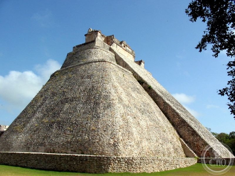
- Pyramid of the Magician: built up in successive phases between roughly 600 and 900 CE, about 35 metres high, with a unique elliptical footprint among Maya pyramids and an elaborate Chaac mask above the western staircase.
- Governor’s Palace: dated to around 900-1000 CE, roughly 100 metres long and 12 metres high, faced with some 24,000 individually fitted mosaic stones and over 150 Chaac masks along the cornice, set on an artificial terrace about 18 metres above the plain.
- Peak population: estimated at 25,000 to 30,000 inhabitants during the Late and Terminal Classic periods.
- Rulers: several kings bore the name Lord Chac; the most recently identified ruler is named Chan Chak K’ak’nal Ajaw.
- Coordinates: 20.3596° N, 89.7715° W.
History
Uxmal grew from a Late Preclassic settlement into a major regional capital during the Late and Terminal Classic periods, with most of its principal structures, including the Governor’s Palace and the Great Pyramid, raised between about 800 and 900 CE under a line of rulers who took the name Lord Chac. The city declined between roughly 1000 and 1200 CE and was largely abandoned, though the area later came under the control of the Xiu, a lineage that had migrated from western Mexico and established itself in the Puuc Hills. In 1441 the Xiu rose against the Cocom lineage, who controlled Chichén Itzá. A century later, in 1541, Francisco de Montejo the Younger completed the Spanish conquest of Yucatán, and Uxmal was absorbed into the encomienda system of colonial land grants.
The site returned to wider attention between 1839 and 1842, when the American traveller John Lloyd Stephens and the British illustrator Frederick Catherwood carried out the first systematic exploration and recording of Uxmal, publishing their findings in 1843. Excavation and restoration by Mexico’s Instituto Nacional de Antropología e Historia has continued since 1988, and the site was inscribed as a UNESCO World Heritage Site in 1996.
Stephens and Catherwood’s two-volume account, Incidents of Travel in Yucatan, was a commercial success and the first illustrated account of Maya ruins to reach a mass readership. Stephens argued, against the prevailing opinion of his day, that the cities had been built by indigenous Americans rather than by Egyptians or other Old World peoples, and the book is credited with launching serious Maya archaeology.
What you see
The Pyramid of the Magician rises in a series of superimposed construction phases, visible in its rounded corners and in the differing styles on its east and west faces. Its western staircase is flanked by a giant Chaac mask whose mouth forms a doorway near the summit, from where the Governor’s Palace is seen laid out below. The Palace itself runs along three rooms in a line, its upper facade covered in mosaic friezes and repeated Chaac masks, and Stephens’s description of it as not unworthy to stand beside the remains of Egypt, Greece and Rome is still quoted at the site.
The Nunnery Quadrangle, named by the Spanish for its resemblance to a convent, consists of four ranges of rooms around a central courtyard, each range decorated in a distinct regional variant of the Puuc style. Nearby stands one of the largest ball courts in Yucatán, aligned with the Governor’s Palace for solar and Venus events, and the House of Turtles, more simply decorated and named for the turtles carved along its cornice. The Great Pyramid and the structure known as the Dovecote remain largely unexcavated and covered in vegetation. In the evening, an illuminated light-and-sound show, said to be the oldest of its kind in Mexico, projects onto the ruins with commentary.
Throughout, the Puuc style is visible in its essentials: smooth, undecorated lower walls giving way to elaborately mosaic-covered upper facades, stacked Chaac masks at corners and cornices, and a corbelled vault construction without a true keystone arch. Unlike Chichén Itzá after 1000 CE, Uxmal shows no sign of Toltec influence, making it the purest surviving example of the style.
Practical information
- Access: Uxmal lies close to the Puuc Route, so travellers arriving by car can combine it with Kabah, Sayil, Xlapak and Labná in one day.
- Entry: a combined INAH and state entry fee applies; current rates and any discounts should be checked through the site’s official channels.
- Evening show: a light-and-sound show runs at the site in the evening, in Spanish and English, at an additional cost; timings vary by season and are best confirmed in advance.
- Best time to visit: the cooler months from November to March are generally recommended.
Getting there
Uxmal is about 62 kilometres south of Mérida along the MEX-261 highway. Buses run from Mérida’s CAME terminal several times a day, or the site can be reached by rental car, which allows visitors to combine Uxmal with the other Puuc Route sites on the same trip.
Nearby
- Kabah — part of the Puuc Route east of Uxmal, known for the Codz Poop, a facade over 50 metres long covered in more than 250 Chaac masks.
- Sayil — a Puuc Route site near Uxmal.
- Xlapak — a smaller Puuc Route site near Uxmal.
- Labná — a Puuc Route site near Uxmal, part of the same architectural circuit.
Sources
- John Lloyd Stephens, Incidents of Travel in Yucatan (1843)
- Instituto Nacional de Antropología e Historia (INAH)
- UNESCO
Find it on the map
See this place and what’s around it →📷 Become a Cultural Heritage Online photographer
Share your photos of places: they stay published under your name as the author. The more they're seen, the more you get noticed — and soon a contest will reward the most appreciated photos.
Log in or sign up free to add a photo