

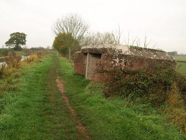
Over 300 pillboxes, 24 miles of anti-tank ditches and a canal turned into a defensive line, built in months under the threat of a German invasion that was expected any week. The invasion never came, and neither, in the end, did anyone the line was built to stop.
At a glance
After the fall of France in the summer of 1940, General Sir Edmund Ironside, commander-in-chief of Britain’s Home Forces, ordered a network of defensive «stop lines» across the country to compartmentalise any German advance inland from a successful invasion. The Taunton Stop Line was one of the longest and most complete: roughly 71–80 km from the Bristol Channel at Highbridge, following the Bridgwater and Taunton Canal, the River Parrett, the Chard Canal and the Great Western Railway line to Ilminster, then the River Axe down to the Devon coast at Axmouth.
Built in a matter of months by men working against a threat nobody could put a date on, it was never tested by the enemy it was designed to stop.
Key facts
- Built: summer–autumn 1940, under General Sir Edmund Ironside, in response to the invasion threat following the fall of France
- Route: roughly 71–80 km, from Highbridge on the Bristol Channel along the Bridgwater and Taunton Canal and the River Parrett, via the Chard Canal and GWR line to Ilminster, then the River Axe to Axmouth on the south Devon coast
- Structures: more than 300 pillboxes (roughly three-quarters of the common FW3 Type 29 design), 61 positions for medium Vickers machine guns, 21 emplacements for First World War–era naval 6-pounder anti-tank guns, 24 miles of anti-tank ditches, concrete blocks and road/rail barriers
- Purpose: to block a German advance from a landing on the Cornwall, Devon or Somerset coast, one of more than fifty similar stop lines built across Britain in 1940
- Combat record: never fully manned, and never saw active service beyond training exercises — the invasion threat receded before the line could be tested, and its anti-tank guns were already being moved to coastal positions by September 1940, before the line was even complete
- Coordinates: 51.0106° N, 3.0442° W (Ruishton, Somerset)
How it was built
The line used what the landscape already offered: a canal and a river system running almost the width of the south-west peninsula, needing only pillboxes and gun positions at the crossing points to become a continuous barrier. That made it fast to build — a summer and an autumn, rather than years — at the cost of relying on water obstacles that a determined enemy with engineering support could, in principle, still cross. Nobody ever got the chance to find out whether the line would have held; it was designed, resourced and completed under a deadline that kept moving as the invasion threat itself moved, and then simply stopped mattering once the threat passed.
A line that never fought
By September 1940, with Operation Sea Lion — the German invasion plan — repeatedly postponed and eventually shelved, the Royal Navy’s old 6-pounder guns earmarked for the Stop Line’s anti-tank positions were already being redeployed to coastal batteries instead, before the line’s construction had even finished. What remained was a fully built defensive system, hundreds of pillboxes and dozens of kilometres of ditches, that existed for the rest of the war as a contingency rather than a front.
Who tells it, and where the accounts diverge
There is no real dispute to report here, and that is itself the point worth making plainly: heritage records for the line are direct about its record — «never fully manned», «never saw active service, other than for training exercises». A structure built at wartime urgency, on the scale of a national engineering project, exists today with no combat history at all, only the fact of having been ready. It sits alongside the Focșani–Nămoloasa–Galați line in Romania as a case of the same shape: enormous defensive effort, poured into a threat that changed direction, or never arrived, before the concrete was tested.
What you see today
- Numerous surviving pillboxes along the Bridgwater and Taunton Canal towpath and at other points along the route, several protected as listed structures.
- A cluster of five pillboxes and a rail block at Ruishton, Somerset, among the best-preserved groups on the line.
- Sections of anti-tank ditch and concrete obstacles survive in the wider countryside, largely unsignposted.
Getting there
The Ruishton pillbox group lies just east of Taunton, Somerset, accessible from the Bridgwater and Taunton Canal towpath.
Nearby
- Taunton itself, the county town the line was named for and one of its key defended points
- Bridgwater and the Somerset Levels, at the line’s northern end
Sources
- Wikipedia, Taunton Stop Line — route, structures, purpose, combat record.
- Somerset Historic Environment Record (Heritage Gateway, MDV119535) — confirmation the line was never fully manned or used in action.
- Historic England, National Heritage List entries for Taunton Stop Line pillbox groups, including the Ruishton cluster.
Find it on the map
See this place and what’s around it →📷 Become a Cultural Heritage Online photographer
Share your photos of places: they stay published under your name as the author. The more they're seen, the more you get noticed — and soon a contest will reward the most appreciated photos.
Log in or sign up free to add a photo