
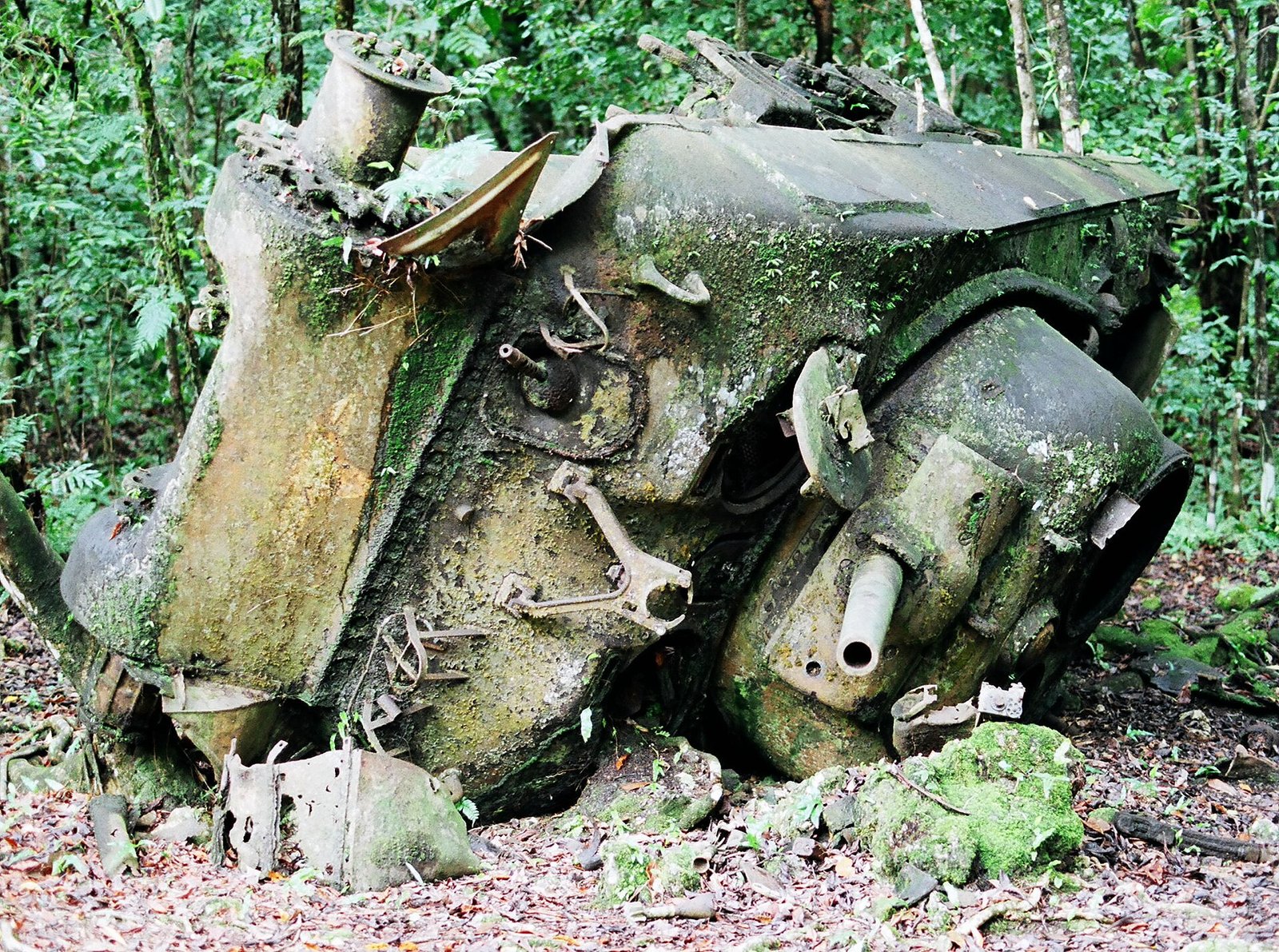
A low coral island with fewer than 500 residents today, honeycombed with some 500 caves and held for ten weeks in 1944. It is the best preserved battlefield of the Pacific war, and the only one where the people who dug the caves, the people who died in them and the people who took them tell three separate stories.
At a glance
Peleliu is a low platform of coral limestone at the southern end of the Palau archipelago. Its spine, the Umurbrogol, is a ridge of sharp coral pinnacles and sinkholes that maps of the period showed as gentle wooded hills. In 1944 that ridge held around 500 caves, natural and cut, linked by tunnels, and it took American forces from 15 September to 27 November to clear them.
Almost nothing has been built over it since. Wrecked vehicles lie where they stopped, cave mouths still hold the equipment left inside, and it is illegal to remove anything from the island. The United States designated it a National Historic Landmark in 1985; on the National Register it carries reference number 85001754. What makes it valuable to a historian is precisely what made it terrible in 1944 — the ground was never cleared, never rebuilt, never tidied.
Key facts
- Battle: Operation Stalemate II, 15 September – 27 November 1944
- Japanese commander: Colonel Kunio Nakagawa, 2nd Infantry Regiment (14th Division)
- Defences: roughly 500 caves in the Umurbrogol, many of them former phosphate mine shafts, linked by tunnels dug by Japanese engineers
- Labour: Palauan, Korean and Okinawan forced labourers, alongside Japanese engineer and naval construction units
- Predicted duration: four days, according to Major General William Rupertus, commanding the 1st Marine Division
- Actual duration: two months, one week and five days
- Protection: US National Historic Landmark, designated 1985 (NRHP 85001754); removal of relics prohibited
- Coordinates: 7.0114° N, 134.2461° E
How the island was fortified
Peleliu was not fortified from nothing. Palau had been administered by Japan since the First World War, first under a League of Nations mandate, and the Nanyo Kohatsu Kaisha — the South Seas Development Company — had been mining phosphate on the island for years. The shafts and galleries already in the coral were the starting point of the defence: a mining landscape converted into a military one, which is why the caves are deeper and better cut than improvised field works usually are.
The work was done under compulsion. The archaeological survey of the island records that Japanese forces used forced Palauan labour to dig many of the caves, alongside Korean and Okinawan forced labourers. The official Marine Corps monograph on the battle, written from captured documents and prisoner interrogations, notes that the most professionally engineered tunnels in the north of the island were the work of the 214th Naval Construction Battalion, a unit made up of former miners: passages of ample size, with cross-tunnels, on a scale the army’s adapted caves did not match. After the fighting the island command counted more than 500 caves.
The tactical thinking behind them was new. Japanese commanders in 1944 had begun to abandon the defence of the waterline and the mass charge, and to fight instead from depth: token resistance on the beaches, then attrition from fortified positions that had to be taken one at a time. Peleliu is where the American forces met that doctrine at full strength, and the pattern set here — caves, tunnels, no surrender, no counter-attack in the open — is the pattern they would meet again at Iwo Jima and Okinawa.
Two Palauan villages had already been demolished to build the Japanese airfield. The remaining three were destroyed in the battle. The islanders were evacuated before the landings, and when they came back in 1946 they found an island with, as the survey puts it, nothing green left on it.
Who tells it, and where the accounts diverge
There are three accounts of this island, and they do not disagree about the fighting. They disagree about what the fighting was for, and about who is in the story at all.
The American account was contested while the operation was still being planned. Admiral William Halsey recommended that the landings be cancelled, on the grounds that the Japanese garrison was already isolated and the threat did not justify the probable cost; Admiral Nimitz overruled him. Major General Rupertus told his officers the island would be secured in four days. It took over two months. The airfield that justified the operation became, in the words of the National WWII Museum’s John Curatola, «a convenient but nonessential air link» — the staging base for the invasion of Okinawa was Ulithi, not Peleliu. The battle then went largely unreported: few correspondents were present, and the news of those weeks was MacArthur’s return to the Philippines and Operation Market Garden.
The casualty figures do not agree either, and the disagreement is instructive rather than suspicious. Curatola gives approximately 9,600 American casualties with 1,600 killed. Compilations that count the whole Palau operation give 1,989 to 2,143 battle deaths and 8,514 wounded, against 12,033 Japanese dead and 360 prisoners. The garrison itself is given as about 7,000 men of the 2nd Infantry Regiment in one account, and as roughly 5,500 army troops plus some 4,000 naval personnel in another. Numbers this far apart usually mean the counts were taken on different boundaries — one island or the whole operation, combat troops or every man present — and a figure quoted without its boundary is not yet a fact.
The Japanese account survives mostly in the ground and in the returning. There was no surrender to record and few prisoners to interview, so what remains is what the caves hold: chopsticks, sake bottles, spectacles, belt buckles, buttons stamped with Imperial Navy insignia. The Japanese government erected a memorial to the war dead of the Western Pacific on the island, and the archaeologists who work at the final command post report finding fresh flowers there on every visit.
The third account is the one that was never written down. The Palauans dug the caves under forced labour, lost two villages to the airfield and three to the battle, and returned in 1946 to a landscape stripped bare. The survey directed by Rick Knecht of the University of Aberdeen and Neil Price of Uppsala University, working with Palau’s Bureau of Arts and Culture and the traditional chiefs, records what that cost: along with the villages the island lost almost all its olangch, the natural and built markers that hold a community’s memories in place. Neither the American nor the Japanese telling of Peleliu has room for that loss, because in both of them the island is a position rather than a place. The archaeology is the first account to treat it as both.
What you see today
- The Umurbrogol ridge, with cave mouths and firing positions still in the coral. The terrain itself is the exhibit: it explains in ten minutes of walking what maps failed to show in 1944.
- The Japanese command post, a concrete building at the foot of the ridge, and the smaller bunkers around the airfield.
- Wrecked vehicles in place — American amphibious tractors and tanks, Japanese guns — left where they were hit.
- The Peleliu Peace Memorial Park and the Japanese memorial to the war dead of the Western Pacific.
- Unexploded ordnance is still present. Demining teams have worked on the island for years. Stay on cleared paths, go with a local guide, and touch nothing: removing relics is a criminal offence, and some of them are still live.
Getting there
Palau is reached by air at Roman Tmetuchl International Airport on Babeldaob, near Koror. Peleliu lies to the south of Koror and is reached by state ferry or small boat. The island had 484 residents at the 2015 census, and accommodation is limited to a few small guesthouses; guides are arranged through Peleliu State, and the battlefield sites are visited by road and on foot.
Nearby
- Angaur, taken in the same operation in September 1944, 10 km to the south-west
- The Rock Islands Southern Lagoon, a UNESCO World Heritage site, between Peleliu and Koror
- Koror, with the Belau National Museum and the Etpison Museum
Sources
- Daniel Weiss, «Place of the Loyal Samurai», Archaeology, July/August 2019 — the Knecht and Price survey, forced labour, the fate of the villages and the olangch, finds inside the caves, preservation of the battlefield.
- John Curatola, «The Battle of Peleliu: The Forgotten Hell», The National WWII Museum — Japanese doctrine, garrison strength, casualties, Rupertus’s prediction, Halsey’s proposal, the airfield’s later value, and why the battle went unreported.
- The Assault on Peleliu, US Marine Corps historical monograph — the count of more than 500 caves, the 214th Naval Construction Battalion and the engineering of the tunnels.
- Wikipedia, Battle of Peleliu — dates, units, the phosphate mines of the Nanyo Kohatsu Kaisha, casualty compilations, Ulithi as the Okinawa staging base. Used as a starting point and cross-checked against the sources above.
Find it on the map
See this place and what’s around it →📷 Become a Cultural Heritage Online photographer
Share your photos of places: they stay published under your name as the author. The more they're seen, the more you get noticed — and soon a contest will reward the most appreciated photos.
Log in or sign up free to add a photo