
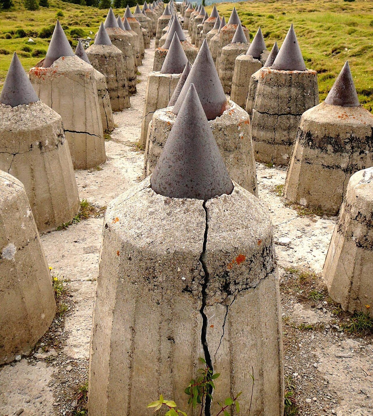
Three lines of concrete teeth on a high bog, and ten works dug into the valley below. Italy built them between 1938 and 1943 against the country it had just signed an alliance with, and the clearest evidence of what was being built here is held in a German archive — because the Germans were photographing the site while the concrete was still wet.
At a glance
The Resia Pass is the western door into Italy from the Austrian Tyrol, at the head of the Val Venosta. Above it, on the Plamort plateau at about 2,000 metres, three parallel rows of anti-tank cones run across open ground, most of them still standing. In the valley below, ten fortified works form the Resia Pass barrier, part of the system Italy called the Vallo Alpino.
What makes the site unusual is the direction it faces. These works were not built against France or Yugoslavia. They were built to stop a German mechanised advance from the north, in the years when Italy and Germany were formally allied — and the alliance was signed while the digging was under way.
Key facts
- Plamort barrier: begun June 1938, altered until 1943; three parallel rows of concrete cones 90–120 cm tall on a 50 cm base, set on timber piles because the ground is peat bog
- Supporting works at Plamort: nine casemates, ten small caponiers, one emplacement for a 75/27 Mod. 1906 battery, and a large cavern work left unfinished
- Resia Pass barrier: ten works in two groups — Romolo in the valley floor, Remo in the mountain, the latter reactivated under NATO
- Planned armament: 22 machine guns, 4 anti-tank guns, 3 guns of 75/27, and one 90/32 in Work 16
- The whole Alpine Wall in South Tyrol: 351 works built of about 800 planned, plus 56 frontier-guard barracks; roughly 19,000 workers; 1.5 million cubic metres of concrete; 544 million lire paid to contractors by 1942
- Ownership: transferred to the Province of Bolzano in 1999 under legislative decree 495 of 21 December 1998; twenty works selected for conservation and public use
- Coordinates: 46.8415° N, 10.5253° E (Plamort plateau)
Built against the ally
Germany annexed Austria in March 1938 without telling Rome in advance, and the Reich’s border arrived at the Brenner. Work at Plamort began that June. On 22 May 1939 Italy and Germany signed the Pact of Steel; on 21 November of the same year Mussolini ordered the fortification of the northern frontier on a massive scale. The two facts sit in the same year and contradict each other, and the fortification is the more reliable witness: a state may say anything in a treaty, but it does not pour 1.5 million cubic metres of concrete in the direction of a friend.
The work was done by private Italian contractors with military engineers, employing around 19,000 men at the peak in 1940–41 at wages of up to 50 lire a day — good money at the time. The hiring had a political filter: men who had opted for German citizenship were not taken on. This was the year of the Options, the agreement under which the German-speaking population of South Tyrol was made to choose between moving to the Reich as German citizens or staying as Italian citizens and giving up recognition as a linguistic minority. The construction site ran straight through a community that had just been asked to divide itself in two, and it hired only one of the halves.
Secrecy was attempted and it failed. Materials were unloaded at railway stations well to the south of where they were needed. The Germans watched anyway, photographing the sites with long lenses and infrared film. Those photographs are now held in the military archive at Freiburg, and were published in 2016 by Alessandro Bernasconi and Heimo Prünster under the title L’occhio indiscreto — Das indiskrete Auge. The best surviving documentation of what Italy was building on this pass is therefore German, and it exists because the ally did not believe the alliance either.
The teeth, and how they were made
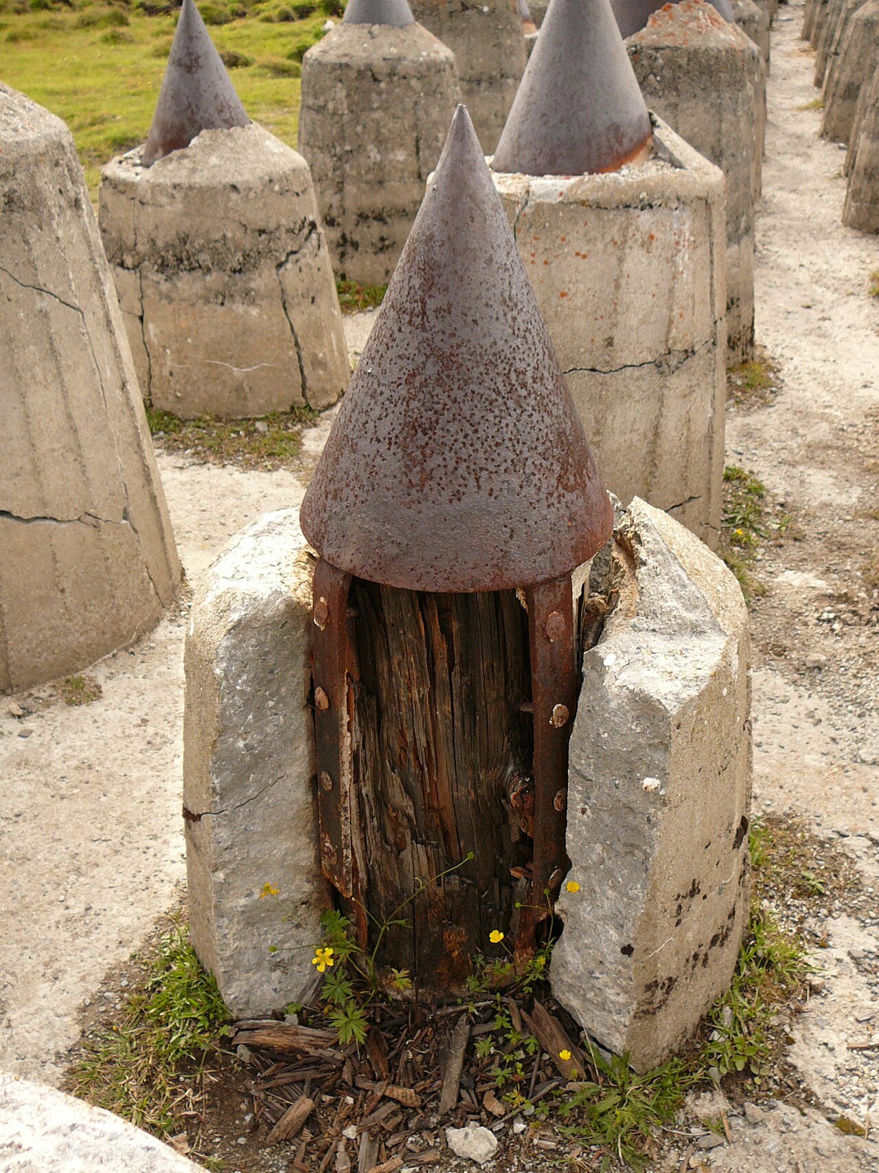
The Plamort obstacle is not a wall but a field: three parallel rows of cones, each between 90 and 120 centimetres high on a base half a metre across, spaced so that a tracked vehicle cannot pass between them and cannot climb over. The ground here is peat, which will not carry a concrete foundation, so each cone was cast around a timber pile driven into the bog. Frost has since split some of the casings open, and where a cone has broken you can see the whole construction logic at once: the wooden pile in the middle, the concrete jacket around it, the iron cap on top to break a track or a hull.
This is an engineering answer to a specific place, not a catalogue item. The Atlantic Wall was a standard type repeated on any coast; the Plamort barrier is what you build when the terrain will not hold what the manual specifies. It is also, as an obstacle, remarkably durable: eighty years of alpine winters have cracked it in places and moved almost nothing.
The works in the valley belong to the other Alpine Wall tradition — tunnels driven into rock, with concrete only where the mountain runs out. Work 20 is the largest of them and the one that can be visited: a cavern work restored with its original water and lighting fittings still in place, opened to the public in the summer of 2011. One of the source springs of the Adige runs channelled through the inside of it: the water that will cross northern Italy passes, at its beginning, through a work built to stop a German advance.
Who tells it, and where the accounts diverge
This is a site where the standard narratives fit badly, and the discomfort is the point.
The Fascist account could not admit what it was building. A regime that had staked itself on the German alliance could hardly announce a fortified line against Berlin, so the works were built under secrecy and never claimed. In the official telling they were simply frontier defences.
The German record, by contrast, is explicit, because espionage has no reason to be tactful: the Freiburg photographs show the sites, dated. When Italy signed the armistice in September 1943, German forces took the region in a matter of days under Operation Achse — a compilation of the standard accounts puts the prisoners taken between Trento and the Brenner at 18 generals, 1,783 officers and 50,000 men. The Alpine Wall was not defended, and the Germans did not put it to offensive use. A fortification that is never fought over leaves no battle to argue about, only a bill.
Then the same concrete changed enemies. From 1948, with Soviet troops still in Austria, part of the system was restored with NATO money and manned by the newly formed Alpini d’Arresto battalions, aimed now at the Warsaw Pact. The works were finally abandoned and sealed in 1992. One barrier, three designated enemies in fifty years, and only the last two ever named in public. The cones on the plateau did not change; the sentence they were said to be part of did, twice.
The local account is the one usually missing. For the families at Curon and Resia these works were, first, a labour market that excluded the neighbours who had opted for Germany; then an occupation; then a military servitude that lasted into the 1990s. In 1950 the valley floor was flooded for a hydroelectric reservoir and the old village of Curon went under, leaving the fourteenth-century bell tower standing in the water. The area is now read internationally through that photograph. The bunkers above it are the same history, told in a material that photographs less well.
Visiting
- Plamort is reached on foot or by mountain bike from Resia (Reschen), climbing to about 2,000 metres. The barrier stands in open ground and is freely accessible; the surrounding works are ruinous and unlit, and the Province secured several of them in 2011.
- Work 20, the cavern work at the pass, has been partly open to the public since the summer of 2011, with a permanent display on the Alpine Wall. Check opening times locally before travelling: mountain sites in the valley open seasonally.
- Take a torch, warm layers and proper boots. Bunker interiors sit at single-figure temperatures all year, and the ground on the plateau is boggy in summer and under snow for much of the year.
- Do not enter sealed or unsecured works. Most of the 351 structures in the province are closed for good reason.
Nearby
- The bell tower of old Curon standing in Lake Resia, the reservoir that flooded the village in 1950
- Glorenza / Glurns, the walled town of the Val Venosta, 20 km south
- Müstair, across the Swiss border, with the Carolingian abbey of St John, a UNESCO World Heritage site
- The Franzensfeste / Fortezza fortress, the provincial museum that has led research on the Alpine Wall since 2019
Sources
- Alessandro Bernasconi and Giovanni Muran, Le fortificazioni del Vallo Alpino Littorio in Alto Adige (Trento: Temi, 1999) — the standard survey of the works, cited throughout the encyclopaedic literature on the barrier.
- Alessandro Bernasconi and Heimo Prünster, L’occhio indiscreto — Das indiskrete Auge (2016) — the German aerial and ground surveillance photographs of the Italian construction sites, held at the military archive in Freiburg.
- Josef Urthaler, Christina Niederkofler and Andrea Pozza, Bunker (Bolzano: Athesia, 2nd ed. 2006) — the works of the Resia Pass barrier and their armament.
- Wikipedia, Vallo alpino in Alto Adige, Sbarramento Passo Resia and Sbarramento Pian dei Morti — dates, counts, costs, the 1999 transfer to the Province, the construction technique at Plamort. Used as a starting point and cross-checked against the bibliography above.
Find it on the map
See this place and what’s around it →📷 Become a Cultural Heritage Online photographer
Share your photos of places: they stay published under your name as the author. The more they're seen, the more you get noticed — and soon a contest will reward the most appreciated photos.
Log in or sign up free to add a photo