
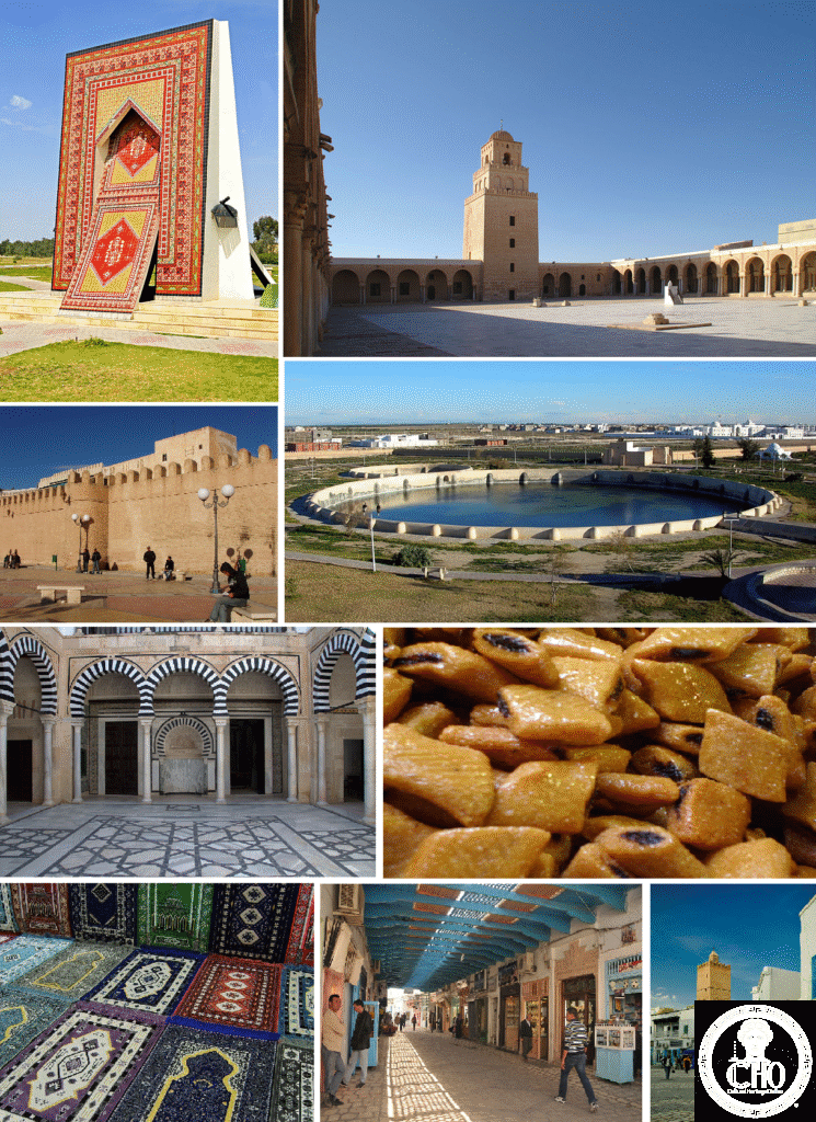
Kairouan holds a rare distinction in Islamic architecture: its Great Mosque carries the oldest standing minaret in the world and a prayer hall built from hundreds of columns lifted from Roman and Byzantine ruins. Regarded as the fourth holiest city in Sunni Islam, it is where the western Mediterranean first became Muslim.
At a glance
Kairouan lies in north-central Tunisia and is considered the fourth holiest city in Sunni Islam, after Mecca, Medina and Jerusalem. A traditional belief widespread across Tunisia and the Maghreb holds that seven pilgrimages to Kairouan are equivalent to one Hajj to Mecca. Founded in 670 CE by the Arab general Uqba ibn Nafi, the city later became capital of the Aghlabid dynasty, which ruled from 800 to 909 CE and built most of the monuments that survive today.
Its Great Mosque, enlarged under the Aghlabids between 836 and 862 CE, is the oldest mosque in North Africa. The Aghlabid Basins, a pair of interconnected water reservoirs built in the ninth century and fed by a distant aqueduct, are considered among the finest surviving examples of early Islamic hydraulic engineering.
Key facts
- Great Mosque minaret: built in 836 CE, a three-storey square tower roughly 36 metres high, each storey narrower than the one below. It is the oldest standing minaret in the world and became the model for square minarets across the Maghreb and Andalusia.
- 414 antique columns: the prayer hall of the Great Mosque is supported by columns of marble, granite and porphyry taken from Roman Carthage, Byzantine churches and other earlier structures. No two capitals match.
- Mosque of the Three Doors: built in 866 CE in the medina, its facade of three carved stone doorways with Quranic inscriptions is regarded as the finest ninth-century carved stonework in Tunisia.
- Aghlabid Basins: ninth-century twin reservoirs, one large and one small, once supplied by an aqueduct and used to store water for the city.
- Coordinates: 35.6781° N, 10.0963° E.
History
The Arab general Uqba ibn Nafi founded Kairouan in 670 CE as a military base for the conquest of the Maghreb. Tradition holds that when he drove his lance into the ground a spring appeared, and he declared the spot the site of a holy city.
Under the Aghlabid dynasty, which ruled from 800 to 909 CE, Kairouan reached its architectural peak, with the Great Mosque enlarged and much of the surviving monumental fabric built. The Aghlabids were overthrown by the Fatimids in 909 CE, and Kairouan served briefly as the Fatimid capital before the seat of power moved to Mahdia in 947 CE. In 1057 CE the city was sacked by the Banu Hilal Arab tribes and never regained its former political standing, though it remained an important centre of Islamic scholarship.
What you see
The medina of Kairouan retains its seventh-century foundations and largely intact walls, making it one of the most completely preserved early Islamic medinas in North Africa. Its streets are lined with carpet workshops producing Kairouan carpets, a flat-weave tradition in which each piece follows a design specific to the weaver’s family. The Zaouia of Sidi Sahab, known as the Barber’s Mosque and dating from the seventeenth century, houses a relic said to be a hair of the Prophet Muhammad and has some of the finest tiled interiors in Tunisia.
Near the Great Mosque stands the Bir Barouta, a well believed by tradition to be connected underground to the Zamzam well in Mecca. A blindfolded camel turns a wheel to draw its water, which pilgrims regard as equivalent to Zamzam water.
Practical information
- Great Mosque access: non-Muslim visitors may enter the courtyard but not the prayer hall. Modest dress is required; a cover-up can be hired at the entrance.
- Medina: free to explore, with carpet-weaving workshops open to visitors near the mosque.
- Aghlabid Basins: located about a kilometre north of the medina, free to enter and lit at night.
- Current entry arrangements and any charges are best checked with the site’s own visitor information before travelling.
Getting there
Kairouan is reached from Tunis-Carthage airport to the north or from Enfidha-Hammamet airport to the northeast, with onward travel by louage, the shared taxis used throughout Tunisia. Exact journey times and fares vary and are best confirmed locally.
Nearby
- El Djem — around 80 km south; the third-century Roman amphitheatre at Thysdrus, with well-preserved lower tiers and accessible underground tunnels, is inscribed as a UNESCO World Heritage Site.
- Sousse — around 60 km northeast; its medina, also a UNESCO World Heritage Site, contains the Ribat of Sousse, built in 821 CE and the oldest surviving fortified Islamic monastery in the Maghreb, along with the Great Mosque of Sousse, dating from 850 CE.
Sources
- Wikipedia, Kairouan
- Wikipedia, Great Mosque of Kairouan
- Wikipedia, Aghlabid Basins
- UNESCO
Find it on the map
See this place and what’s around it →📷 Become a Cultural Heritage Online photographer
Share your photos of places: they stay published under your name as the author. The more they're seen, the more you get noticed — and soon a contest will reward the most appreciated photos.
Log in or sign up free to add a photo