
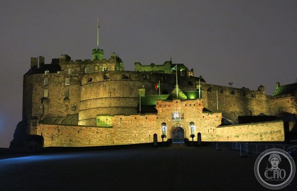
Two cities in one, divided by a valley and by history. Edinburgh’s Old Town descends narrow and steep from the castle along the Royal Mile, a medieval maze of closes and wynds; facing it, the Georgian New Town lays out the geometric order of the Scottish Enlightenment. The contrast is its signature.
At a glance
The Scottish capital owes its World Heritage status to the dramatic contrast of its two historic centres. The medieval Old Town descends the ridge from the castle along the Royal Mile in a dense maze of tall tenements, closes and wynds. Facing it across a valley, the Georgian New Town, laid out from the 1760s, embodies the order and elegance of the Scottish Enlightenment in broad streets and classical squares. Together they form one of the most remarkable urban landscapes in Europe, inscribed by UNESCO in 1995.
Key facts
- UNESCO: World Heritage since 1995 (Old and New Towns of Edinburgh)
- Old Town: medieval ridge from the Castle to Holyrood along the Royal Mile
- New Town: Georgian planned town from the 1760s, by the young architect James Craig
- Charlotte Square: a New Town set-piece designed by Robert Adam
- Edinburgh Castle: the fortress on an extinct volcanic crag dominating the city
- Enlightenment: the city of Hume, Adam Smith and the Scottish Enlightenment
History
Edinburgh grew up around its castle rock, a natural stronghold, with the medieval town spilling down the tail of the ridge toward the abbey and palace of Holyrood. Confined within its walls, the Old Town built upward into some of the tallest tenements of their age, layered along narrow closes — crowded, dramatic and insanitary.
In the later 18th century the city broke out of its medieval shell. A competition won by the young James Craig produced the rational grid of the New Town across the drained Nor Loch valley, soon graced by Robert Adam’s Charlotte Square. As the home of David Hume, Adam Smith and their circle, Edinburgh became a capital of the European Enlightenment, the “Athens of the North”.
What you see
The Royal Mile runs from the castle on its crag down to the Palace of Holyroodhouse, lined by St Giles’ Cathedral and the dark closes of the Old Town. Across Princes Street Gardens, in the valley once filled by the Nor Loch, the New Town spreads in disciplined terraces, crescents and squares of pale stone.
From Calton Hill or the castle ramparts the two towns face each other, medieval against Georgian, in a single sweeping view.
Practical information
- Castle: admission charged; book ahead in summer and during the Festival
- Old and New Towns: freely walkable; many closes and gardens are open
- Time needed: a full day, more during the August festivals
- Note: the city is very busy each August for the Festival and Fringe
Getting there
Edinburgh is the capital of Scotland. Edinburgh Waverley station, in the valley between the two towns, has fast trains from London (about 4.5 hours) and across Scotland; the airport links to the centre by tram. GPS: 55.9486° N, 3.1910° W.
Nearby
- Palace of Holyroodhouse — the monarch’s official Scottish residence, at the foot of the Royal Mile
- Arthur’s Seat — the extinct volcano and hill park above the city
- Forth Bridge — the great Victorian railway bridge, also UNESCO-listed, to the west
Sources
- UNESCO World Heritage Centre — “Old and New Towns of Edinburgh” (ref. 728)
- City of Edinburgh Council — Edinburgh World Heritage, official body
- Encyclopaedia Britannica — Edinburgh
Find it on the map
See this place and what’s around it →
📷 Become a Cultural Heritage Online photographer
Share your photos of places: they stay published under your name as the author. The more they're seen, the more you get noticed — and soon a contest will reward the most appreciated photos.
Log in or sign up free to add a photo