
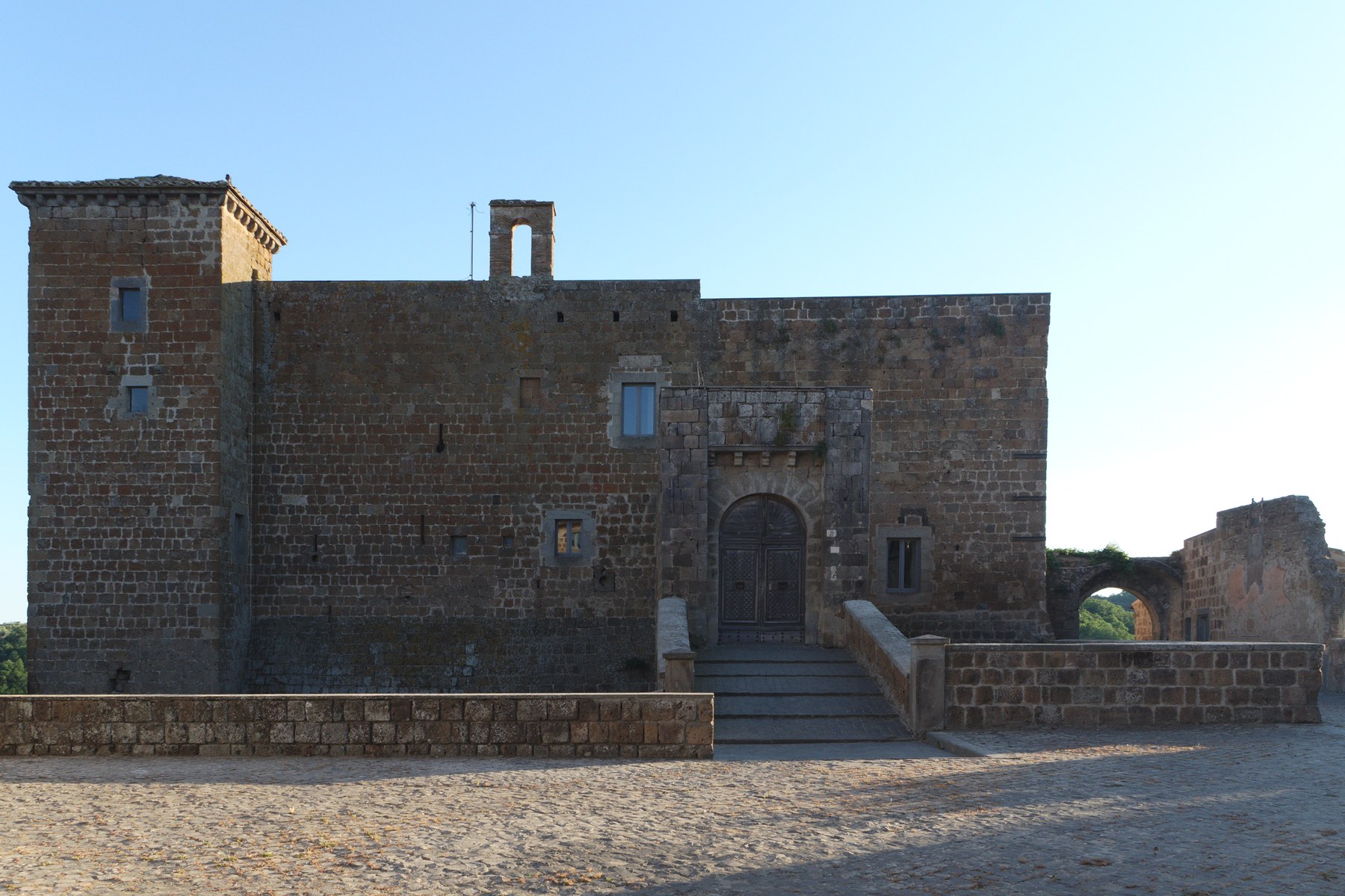
The old village of Celleno was not left to die. It was closed by a vote, emptied by decree, and then blown up with dynamite so that nobody could move back in. What is left on the tuff spur — a castle, two gates, a church, the shells of houses — is now open to visitors as a museum.
At a glance
- What — the abandoned medieval centre of Celleno, on a tuff spur 341 m above sea level; known locally as il Castello and to visitors as the Borgo Fantasma.
- Where — province of Viterbo, Lazio, in the Teverina between Lake Bolsena and Lake Alviano; about 1.5 km east of the modern town of Celleno.
- Emptied — by resolution of the town council on 18 March 1951, completed by presidential decree at Christmas of the same year.
- Now — a museo diffuso of popular culture, with rooms fitted out inside the surviving buildings; open-air stage for the Teverina Buskers Festival in September.
- Do not confuse — Celleno Vecchio with Celleno Nuovo, the twentieth-century town built 1.5 km away around Piazza della Repubblica.
History
Celleno stands on a spur of volcanic tuff at the watershed between two ravines, the fosso delle Briglie to the north and the fosso Calenne to the south, both of them right-bank tributaries of the Tiber. The rock is the same material, and the landscape the same landscape, as Civita di Bagnoregio a few kilometres away: soft tuff laid over a bed of clay and sand, cut back by water until the plateau stands on a pedestal that is slowly going. Settlement here is old — an Etruscan cistern survives under the village, reused in the Middle Ages as a rubbish pit, and a sixth-century BC jar for rearing dormice is kept in the museum in the old centre.
In the fifteenth century the place belonged to the Gatti; from 1527 to 1580 it was a fief of the Orsini, who gave the castle the name it still has. From the end of the sixteenth century it returned to the Papal State, lost its strategic value and began a long decline.
Four centuries of knowing
What makes Celleno unusual is that the danger was documented for nearly four hundred years before anything was done about it. The town statute of 1572 already laid down penalties for anyone digging pits in the tuff, on the grounds that it weakened the rock. Seventeenth-century records continue to note collapses and unsafe houses. After the earthquake that struck the Teverina and Bagnoregio in 1695, hard measures were taken: no more cellars were to be cut inside the castle, and the town walls and the damaged houses of the Piazzarella and Ripa quarters were to be rebuilt.
Then, on 8 June 1931, an earthquake of intensity IV on the Mercalli scale with its epicentre at Celleno itself made the instability worse. By 1934 conditions inside the walls were desperate and some of those made homeless were sheltered in a villa outside. A new settlement was laid out down the hill in the 1930s. As late as September 1946 the under-secretary Giulio Andreotti was writing to the mayor, Luigi Crescia, to reassure him that he was pressing the public works office about the unsafe houses.
Closed by vote, and by dynamite
On 18 March 1951 the town council resolved to move the population from old Celleno to the new settlement. On Christmas Eve of that year the President of the Republic, Luigi Einaudi, signed the act that ended the old town, transferring the remaining inhabitants compulsorily. Then the houses of the historic centre were demolished with dynamite — not out of haste, but deliberately, to stop people coming back to use the cellars and the animal shelters underneath.
That last detail is the one worth carrying away. Celleno did not empty because life drifted elsewhere. It emptied because the state decided it must, and then removed the possibility of return. The same thing happened in those years at other places in the Teverina; at Calcata the inhabitants refused, and the village survives.
What you see
The whole walled area on the plateau is what the inhabitants have always called il Castello — a castrum, a fortified settlement — and it is not the same thing as the castle building inside it.
The Castello Orsini is the best preserved structure and still organises the plan of the village. It faces piazza del Mercato behind a defensive curtain more than ten metres high; you reach it either along via del Ponte, which comes into the main square through the Porta Vecchia, or across the market square itself. Walking round the ditch you can see the heavy battered masonry that strengthens the fortress and the Torre Piccola, and then the double arch of the drawbridge. The front has kept its plain defensive character. In the twentieth century the building served as the town hall; later it became the home of the painter Enrico Castellani (Castelmassa 1930 – Celleno 2017), one of the leading figures of European art after 1945, who died here.
The church of San Donato stands within the walls. Its main door is a fifteenth-century portal of shaped blocks with a deep torus moulding and jambs worked with dentils and diamond points; in the eighteenth century the church was rebuilt with its axis turned through ninety degrees and its interior remade in three neoclassical aisles. San Donato is the patron of the town, and his feast falls on 14 September.
Outside the walls, downhill to the south-west, is the former convent of San Giovanni Battista. Its church keeps a small Romanesque apse whose outer face carries a run of Lombard hanging arches, probably of the tenth or eleventh century. A Franciscan community settled there from 1610; the building was badly damaged in the earthquake of 1695, and carries frescoes of the sixteenth and seventeenth centuries, with the cloister galleries painted in 1716 by one of the friars. Suppressed in 1875, recovered by the friars, it was finally sold to a private owner in 1968.
Cultural significance
Abandoned villages are usually read as a story about depopulation, and Celleno is not that story. The documents run in an almost unbroken line from a municipal statute of 1572 to a presidential decree of 1951, and they all say the same thing: the rock is going, and people live on it anyway. Four centuries of measures — fines for digging, bans on cellars, rebuilding orders, relief for the homeless — and then, when the measures ran out, the demolition of the houses to make the decision irreversible. It is one of the clearest cases in Italy of a settlement ended by administrative act rather than by drift.
The second thing that makes it worth a journey is what has been done with it since. The old centre has not been left as a picturesque ruin: it is run as a museo diffuso of popular culture, with rooms inside the surviving buildings given over to the objects of ordinary life, one to the archaeology of the site, another to radio sets, sound equipment and other twentieth-century tools. That is an unusual choice. A village emptied by the state has been refitted with exactly the things the state moved out.
Practical information
- The site is managed and ticketed, with the museum rooms inside the buildings; it is not an open ruin to be wandered at will, and opening hours vary with the season. Check with the municipality of Celleno before travelling.
- The ground is uneven, with steps, cobbles and drops: sensible shoes, and care with children.
- In September the village becomes the stage for the Teverina Buskers Festival.
- The feast of San Donato, patron of the town, falls on 14 September.
Getting there
Celleno lies in the Teverina, on the right bank of the Tiber between Orvieto and Orte, and is reached from Viterbo (about 20 km to the south-west) or from the A1 at the Orte or Attigliano exits. The abandoned village is about 1.5 km east of the modern town: leave Celleno Nuovo, with its Piazza della Repubblica, and follow the signs for the Borgo Fantasma; the approach ends at via del Ponte and piazza del Mercato, in front of the castle. Nearby, and made of the same geology, are Civita di Bagnoregio and the Valle dei Calanchi; south of the municipal boundary the stream of the Infernaccio cuts a gorge with walls over sixty metres high, a waterfall and iron-red water.
Sources & resources
- Celleno — the geology of the spur, the statute of 1572, the earthquake of 1695, the earthquake of 8 June 1931 with its epicentre at Celleno, the events of 1934 and 1946, the council resolution of 18 March 1951, the presidential act of Christmas 1951 and the demolition with dynamite, the Orsini fief of 1527–1580, the Castello Orsini, San Donato, the convent of San Giovanni Battista, and the historic centre as a museo diffuso.
- Comune di Celleno — for current opening times and visiting arrangements.
- Enrico Castellani (Castelmassa, 4 August 1930 – Celleno, 1 December 2017).
- OpenStreetMap, for the position of the locality named Celleno Vecchio, of the castle, the two town gates, via del Ponte and piazza del Mercato, and for the 1.5 km between the old village and the modern town.
Find it on the map
See this place and what’s around it →Events here — now on & upcoming
📷 Become a Cultural Heritage Online photographer
Share your photos of places: they stay published under your name as the author. The more they're seen, the more you get noticed — and soon a contest will reward the most appreciated photos.
Log in or sign up free to add a photo