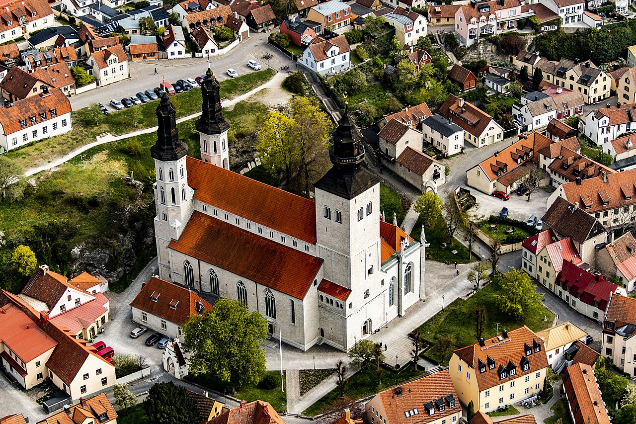
The Hanseatic Town of Visby, inscribed in 1995, is the best-preserved medieval Hanseatic city in northern Europe — a walled trading port on the Swedish island of Gotland that was the commercial gateway to the Baltic in the twelfth and thirteenth centuries, whose circuit of twelfth-century town walls, the Cathedral of Saint Mary, and twelve ruined medieval churches document both the extreme wealth and the abrupt decline of a Hanseatic trading city. The Agricultural Landscape of Södra Öland, on the neighbouring island, extends the Swedish heritage itinerary.
Hanseatic Town of Visby: Wealth in Stone, Ruin in Silence Gotland island, Baltic Sea
The Hanseatic Town of Visby, inscribed in 1995 under criterion (iv), is the most completely preserved medieval urban ensemble in Scandinavia — a walled city on the western coast of Gotland island (the largest island in the Baltic Sea) that served as the most important trading port of the northern European Hanseatic League from the late twelfth to mid-fourteenth century. The Hanseatic League was a commercial confederation of northern European trading cities that controlled Baltic and North Sea trade from c. 1241 to 1669 CE; Visby’s position on Gotland (midway between Sweden, Germany, the German-Baltic ports, and Novgorod in Russia) made it the natural entrepôt for the transit trade in furs, wax, grain, cloth, and herring that sustained the League’s commercial power. At the height of its prosperity (c. 1200–1361), Visby had a population of approximately 8,000 — enormous for a Baltic island — with over sixteen churches (of which thirteen survive, only one intact), a town hall, a stone-built merchant quarter, and a ring of defensive walls that represents the most extensive surviving twelfth-century fortification in Scandinavia. The city’s decline was sudden and complete: in 1361, the Danish king Valdemar IV Atterdag sacked and plundered Visby, destroying its commercial dominance; the city lost population, the churches fell into ruin, and Gotland was transferred between Sweden and Denmark multiple times before becoming permanently Swedish in 1645. The ruins were never rebuilt; instead, Visby became a small fishing and agricultural town within its medieval walls, its ruined churches maintained as tourist attractions from the nineteenth century.
The Town Walls: 3.5 km of Medieval Limestone Entire town perimeter, walkable
The town walls of Visby (constructed in the twelfth through fourteenth centuries, substantially intact for 3.5 km of their original 3.6 km perimeter, with 27 of the original 29 towers surviving) are the most extensive and best-preserved medieval urban fortifications in Scandinavia and among the most intact in Europe. The walls are built of the local limestone (kalksten) that characterises all medieval construction on Gotland — a honey-coloured sedimentary rock that was the building material of the entire island and was exported across the Baltic in the medieval period. The three town gates (Norderport, Söderport, and Österport) survive intact; the full circuit of the walls can be walked on the exterior at street level in approximately 2 hours. The walls are not defensive in the conventional sense of castles — they lack moats, and the towers are not positioned for flanking fire — but they demarcate the commercial settlement from the surrounding agricultural land and control access to the port, reflecting the Hanseatic commercial conception of the city as a trading institution rather than a military stronghold.
Ruined Churches: Testimony to the Hansa Decline Various locations within the walled town
Twelve of Visby’s thirteen medieval churches (built between c. 1150 and 1350) are ruins — their walls intact but their roofs missing, their floors open to the sky, their carved stone decorations weathered but legible. The ruins are not the result of war or fire but of the population decline that followed the Danish sack of 1361 and the subsequent contraction of Baltic trade: too few inhabitants remained to maintain thirteen churches, and the Protestant Reformation of 1527 closed the monasteries (including the Dominican and Franciscan convents, whose ruins survive in the northern part of the city). The most evocative ruins are the church of Saint Catherine of Alexandria (Sanct Karin, c. 1233, Dominican, whose red brick nave arches stand against the sky in the centre of the city), the church of Saint Nicholas (Sanct Niklas, the largest ruin, with its west facade still complete to full height), and the church of Saint Mary’s Annex (Helge And, c. 1300, with Romanesque carved capitals). Only the Cathedral of Saint Mary (Domkyrkan, begun c. 1190, extended and modified through the fifteenth century) is intact, functioning as the Lutheran parish church of Visby since the Reformation.
Agricultural Landscape of Södra Öland: A Living Iron Age Field System 🚢 ~3 hrs by ferry to Öland mainland crossing
The Agricultural Landscape of Southern Öland (Södra Öland), inscribed in 2000 under criteria (iv) and (v), is on the neighbouring Swedish island of Öland (accessible from Kalmar on the mainland by a 6 km bridge, then approximately 200 km south down the island). The inscription covers a landscape of exceptional agricultural continuity: the limestone alvar plateau of southern Öland has been farmed in an open-field strip system since the pre-Roman Iron Age, a system that survived the enclosure movements of the eighteenth and nineteenth centuries because the poor, thin soil of the alvar made large-scale mechanised agriculture uneconomical. The traditional land-use (common grazing on the alvar, individual strip cultivation in the village fields, hay-making in the meadows) is still practised by approximately 200 farmers in the seven inscribed villages; the field patterns, village layouts, and windmill silhouettes that characterise the landscape document a 2,000-year continuity of agricultural land use that is unique in northern Europe.
Practical information
Visby is reached by ferry from Nynäshamn (90 mins south of Stockholm by commuter train, then 3-hour ferry) or Oskarshamn (4-hour ferry); during peak season (June–August) additional routes from Västervik and Grankullavik operate. Destination Gotland ferries run year-round. There are also flights from Stockholm Arlanda, Stockholm Bromma, and Gothenburg to Visby Airport (a few km from the walled city). The walled city is entirely walkable; the cathedral, all 12 church ruins, and the walls can be covered in a full day. The ruins are freely accessible at all times (no entrance fee). The Medieval Week festival in Visby (first week of August) draws 40,000 visitors for jousting, markets, and period drama — accommodation must be booked a year in advance for this week. The best season outside of festivals is May–June and September, with fewer crowds and mild temperatures. Öland is accessible by road bridge from Kalmar; the distance from Visby by ferry + car is approximately 300 km.
Frequently Asked Questions
Is Visby a UNESCO World Heritage Site?
Yes. The Hanseatic Town of Visby was inscribed in 1995 under criterion (iv). The inscription covers the walled medieval city of Visby on Gotland island, including the town walls (3.5 km, 27 towers), the Cathedral of Saint Mary, and the twelve ruined medieval churches — an ensemble that documents the commercial, architectural, and urban heritage of the Hanseatic League trading system in its northern extent.
What was the Hanseatic League and why was Visby important to it?
The Hanseatic League (Hansa or Hanse) was a commercial confederation of northern European trading cities — principally German, but including cities in the Baltic states, Scandinavia, the Low Countries, and England — that collectively dominated North Sea and Baltic trade from the mid-thirteenth to mid-seventeenth centuries. The League controlled the trade in salted herring (from the Scanian herring fair in Sweden), grain (from Prussia and Poland), timber (from the Baltic), wool (from England), and luxury goods (Russian furs from Novgorod) through a network of trading posts (Kontore) in London, Bruges, Bergen, and Novgorod. Visby’s importance derived from its position: a well-harboured island at the maritime crossroads between Sweden, Germany, Russia (via the Gulf of Finland), and Denmark, where ships from all directions could meet, trade, and refit. Gotland was also an independent political entity (not firmly under any Scandinavian king until the late medieval period), which made Visby a neutral ground for trade.
Why are so many churches ruined in Visby?
Visby had at least 16 churches in its period of peak prosperity (c. 1200–1361) — an extraordinary number for a city of 8,000 people, reflecting the wealth of individual merchant guilds and nationalities who each maintained their own church (the Germans had Saint Peter, the English Saint James, and so on). After Valdemar IV’s sack of 1361 and the subsequent decline of Baltic trade, the population fell too far to maintain all the churches; the Protestant Reformation of 1527 closed the monastery churches; and the remaining congregations consolidated into the Cathedral of Saint Mary, leaving the others to decay. The Swedes who took permanent control in 1645 did not demolish the ruins for building material (as often happened elsewhere) because Gotland’s abundant quarried limestone made it cheaper to cut new stone than salvage old; the ruins remained standing and became objects of romantic admiration in the nineteenth century, when they were first systematically preserved.