

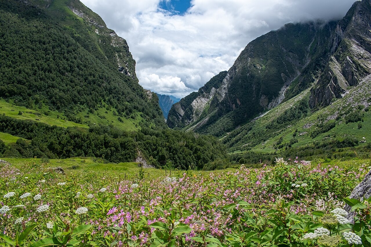
The Nanda Devi and Valley of Flowers National Parks, first inscribed by UNESCO in 1988 and extended in 2005, form a contiguous protected landscape in the Garhwal Himalaya of Chamoli District, Uttarakhand — one of the most botanically rich high-altitude sites in India, combining a closed wilderness sanctuary around one of the subcontinent’s highest peaks with a seasonally accessible valley holding more than 500 species of alpine wildflowers. The Valley of Flowers opens only between June and October; for the remaining eight months it lies under snow and ice, accessible to no one.
Nanda Devi: the closed sanctuary Inner Sanctuary closed to all visitors since 1983; outer zone trekking accessible via permit
Nanda Devi, at 7,816 metres, is the second highest peak located entirely within India — only Kangchenjunga exceeds it, and Kangchenjunga straddles the Nepal border. The mountain is surrounded by a ring of subsidiary peaks forming a near-continuous ridge that encloses a deep inner basin, the Nanda Devi Sanctuary, drained by the Rishi Ganga gorge — one of the deepest and most technically difficult river gorges in the Himalaya, which until the 1930s effectively prevented any outsider from reaching the inner basin. The first confirmed penetration of the gorge and entry into the Sanctuary was made by British mountaineers Eric Shipton and Bill Tilman in 1934, after multiple earlier attempts had failed at the gorge walls. Their account described a pristine high-altitude basin of extraordinary scale and beauty, ringed by peaks above 6,000 metres and supporting wildlife that had no experience of human hunters.
The Indian government declared the Nanda Devi inner Sanctuary off-limits to trekking and mountaineering in 1983, following a period in the 1970s and 1980s when expeditions — including a CIA-sponsored operation that attempted to install nuclear-powered monitoring equipment on the summit ridge during the Cold War — had caused visible ecological damage to the high-altitude meadows and moraine systems. The closure was one of the earliest examples in South Asia of a complete wilderness designation responding directly to expedition impacts. It remains in force: the inner Sanctuary is closed to all visitors, and the wildlife it contains — including significant populations of snow leopard (Panthera uncia), Himalayan brown bear, bharal (blue sheep, Pseudois nayaur), Himalayan musk deer (Moschus leucogaster), and the high-altitude bamboo species ringsaal — exists in conditions approaching pre-contact wilderness. The outer zone of the Nanda Devi National Park is accessible to trekkers with permits obtained from the Uttarakhand forest department; the routes through the outer zone offer views of the summit and access to high-altitude landscapes but do not enter the inner basin.
The biosphere reserve that encompasses both parks extends across 5,860 square kilometres and contains the watershed systems feeding the Alaknanda River, a major tributary of the Ganges. The combination of elevation range — from approximately 3,500 metres at the lowest accessible points to 7,816 metres at the Nanda Devi summit — and the isolation of the inner basin creates conditions for high biodiversity and evolutionary distinctiveness in the plant and animal communities. The UNESCO inscription specifically cites the representation of major Himalayan ecosystem types within a single protected area as a key Outstanding Universal Value.
The Valley of Flowers: alpine flora and the botanist’s Himalaya Ghangaria base camp 14 km on foot from Govindghat; valley entrance 4 km beyond Ghangaria
The Valley of Flowers National Park occupies a 90 square kilometre high-altitude valley at elevations between 3,352 and 3,658 metres, running roughly east-west along the Pushpawati River, a tributary of the Alaknanda. The valley floor, a broad glacial U-shape, fills with wildflowers between June and mid-September as the monsoon rains break through the Himalayan barrier and the snowmelt of the previous winter combines with seasonal rainfall to sustain an extraordinary density of plant life in the thin, bright air. More than 500 alpine plant species have been recorded in the valley, many of which are found nowhere else in India or only in a handful of other high-altitude Himalayan locations.
The valley entered the English-reading world through Frank Smythe’s 1938 book “The Valley of Flowers,” written after Smythe and Eric Shipton — the same Shipton who had penetrated the Nanda Devi gorge four years earlier — stumbled across the valley in 1931 while descending from a successful ascent of Kamet (7,756 metres), having become disoriented in poor weather. Smythe’s lyrical account of a hidden valley of improbable floral abundance reached a wide audience during a period when armchair Himalayan travel was popular in Britain. The valley had of course been known to the local Garhwali community for centuries and was considered a sacred place — the abode of gods and spirits — by the communities of the Bhyundar valley below, who traditionally did not enter it.
Among the most botanically significant species is the Brahma kamal (Saussurea obvallata), the state flower of Uttarakhand: a thistle-relative that grows at high elevations, encloses its flower head within translucent papery bracts, and blooms only at night. It appears in Hindu mythology as the flower of the god Brahma and is offered at the Hemkund Sahib Sikh shrine adjacent to the valley. The blue Himalayan poppy (Meconopsis aculeata) is among the showiest of the valley’s plants, its clear sky-blue flowers appearing from July onward. Multiple primula species, various potentillas, anemones, daisies, and orchids contribute to a succession of flowering phases across the season, meaning the visual character of the valley changes significantly between a June visit (early-season, sparse but intense) and an August visit (full monsoon, maximum density, occasional cloud and rain). A memorial plaque near the valley entrance commemorates British botanist Joan Margaret Legge, who fell to her death while photographing flowers in the valley in 1975 and whose ashes were scattered there.
Practical information
The standard approach begins with a flight or overnight train to Haridwar or Rishikesh in the Garhwal foothills. From there, shared jeeps and buses run to Joshimath (250 km, approximately 8–10 hours by road along the Alaknanda valley) or directly to Govindghat, the trailhead (269 km from Rishikesh). The 14 km trek from Govindghat to Ghangaria (also spelled Ghangaria or Bhyundar), the base village, gains approximately 1,200 metres of elevation and takes 5–7 hours at a moderate pace; mules and porters are available for hire at the trailhead for those who need them. The 4 km trail from Ghangaria to the valley entrance gains a further 400 metres. Ghangaria has simple guesthouses and a few small restaurants; no accommodation exists within the valley. The valley is open to visitors from 1 June through 31 October (check current forest department rules, which can change year to year). Entry requires a permit purchased at the Ghangaria forest office. The optimal flowering season is July and August, coinciding with the heaviest monsoon rains; visitors should carry waterproof clothing and expect daily afternoon cloud and precipitation. Altitude sickness is a real risk for those arriving directly from low elevations: an acclimatisation night at Joshimath (1,890 m) before continuing to Ghangaria (3,048 m) is strongly recommended.
Frequently Asked Questions
Why is the Nanda Devi inner Sanctuary closed, and is it likely to reopen?
The closure of the Nanda Devi inner Sanctuary in 1983 was driven by documented ecological damage from the cluster of mountaineering expeditions that entered the basin in the 1970s. The most controversial was a series of CIA-sponsored operations between 1965 and 1968 intended to install a plutonium-powered monitoring device on the summit ridge to track Chinese missile tests — a device that was lost in an avalanche on one expedition and never recovered, raising concerns about plutonium contamination in the Rishi Ganga watershed that persisted for decades. Beyond the intelligence-related activity, the volume of conventional mountaineering expeditions to Nanda Devi throughout the 1970s had stripped the inner basin of fuel wood, left significant waste, and disturbed the high-altitude meadow vegetation. The Indian government’s 1983 closure was framed as an indefinite conservation measure rather than a temporary restriction, and successive governments have maintained it. Periodic proposals to reopen the inner Sanctuary to controlled trekking have been advanced by tourism advocates and some political figures, but the conservation community and the scientific researchers who have studied the ecosystem in the closure period have consistently opposed reopening, citing the recovery of wildlife populations and vegetation during the four decades of protection. As of the most recent information available, the inner Sanctuary remains closed with no announced timeline for reopening.
What is the best time of year to see the Valley of Flowers at its peak?
The flowering season in the Valley of Flowers runs from approximately mid-June through mid-September, but the composition and density of the display change significantly across this window. The early weeks of June, when the valley first becomes accessible after snow clearing, offer the first emergent flowers in a landscape still patchy with snow — vivid against white, but sparse. By mid-July, as the monsoon establishes itself and soil moisture builds, the valley floor transforms into the dense, multi-species carpet that photographs convey: the broad flat terrain covered in sweeping masses of blue poppies, yellow potentillas, pink impatiens, and white anemones, with the Pushpawati stream running through the centre and the snow peaks visible above the cloud level between rain events. The period from approximately 15 July to 15 August is generally considered peak bloom, with maximum species diversity and highest overall density. Late August and September see the bloom tapering as plants go to seed, though some species — including several high-altitude asters and the Brahma kamal — peak in late season. The monsoon means that clear days alternate with overcast and rainy periods throughout July and August; afternoon cloud cover is almost universal. The practical implication is that a visit of at least 2–3 nights at Ghangaria, rather than a single day, significantly improves the likelihood of catching a clear morning in the valley at or near peak bloom.
What is the Hemkund Sahib and how does it relate to the Valley of Flowers?
Hemkund Sahib is a Sikh pilgrimage site located at 4,329 metres above sea level on a glacial lake (Hemkund, meaning “bowl of snow” in Sanskrit) approximately 6 km beyond Ghangaria on a separate trail that forks from the Valley of Flowers approach. The site marks the location described in the autobiographical account of the tenth Sikh Guru, Gobind Singh, who wrote that in a previous life he had meditated beside a lake in the Himalaya surrounded by seven peaks. Sikh scholars identified Hemkund as the lake described in the text in the late 19th century, and the gurudwara (Sikh temple) built beside the lake became a major pilgrimage destination after road access to Govindghat improved in the 1960s and 1970s. During the summer pilgrimage season (June through October) tens of thousands of Sikh pilgrims make the ascent to Hemkund Sahib — a much larger flow of visitors than the Valley of Flowers itself receives. The pilgrimage brings significant infrastructure to Ghangaria, which functions as the base camp for both destinations, but also creates considerable pressure on the trail between Govindghat and Ghangaria. The Brahma kamal, which flowers in August near Hemkund’s lakeshore, is offered by both Hindu pilgrims at the lake and Sikh pilgrims at the gurudwara, representing a convergence of two distinct religious traditions around the same botanical symbol in the same high-altitude landscape.
Sources
- S1 — Kala, Chandra Prakash. The Valley of Flowers: Myth and Reality. International Book Distributors, 2005. ISBN 978-81-7089-322-6.
- S2 — Rawat, G. S. Flora of Nanda Devi Biosphere Reserve. Wildlife Institute of India, 2000. ISBN 978-81-85496-08-5.
Spotted an error? Write to editorial@culturalheritageonline.com and we correct it the same day.

.jpg)