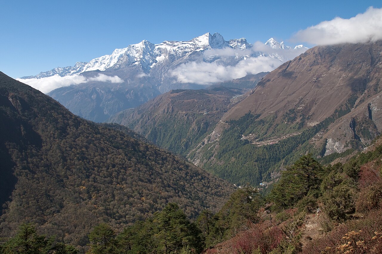
Sagarmatha National Park takes its name from the Nepali word for Mount Everest — “forehead of the sky” — and covers 1,148 square kilometres of terrain that rises from 2,845 metres at its lowest point to 8,848.86 metres at the world’s highest summit. Edmund Hillary and Tenzing Norgay reached that summit on 29 May 1953, after approximately eight weeks of movement between Base Camp and the upper mountain — not a single dramatic push but a staged sequence of load-carrying, camp establishment and acclimatisation that required the combined effort of over 400 porters, 35 Sherpa high-altitude staff and seven other climbing members. UNESCO inscribed the park in 1979, the same year it listed Kathmandu Valley 170 kilometres to the southwest.
The Mountain, the Measurement and the Men Who Climbed It Namche Bazaar gateway at 3,440 m, 2–3 days’ walk from Lukla airstrip
Everest was not always known to be the world’s highest peak. The Survey of India began systematic triangulation of the Himalayan range in the 1840s under Surveyor General Andrew Waugh. Direct access to the mountains was politically impossible — Nepal and Tibet were both closed to foreigners — so measurements were taken from six separate survey stations in the plains of Bihar and Bengal, more than 150 kilometres from the peak. In 1856 Waugh published his calculations: the mountain then designated Peak XV stood at 29,002 feet (8,840 metres). He named it after his predecessor, Sir George Everest, contrary to Everest’s own wishes. The Nepali name Sagarmatha was formalised only in the 1960s; the Tibetan name Chomolungma (“Goddess Mother of the World”) predates all external surveys.
The figure was revised several times through the 20th century. The most recent official measurement, completed jointly by Nepal’s Survey Department and the Chinese National Administration of Surveying in 2020, established the height as 8,848.86 metres — 86 centimetres higher than the previous internationally accepted figure of 8,848 metres. The difference reflects improvements in GPS-based geodetic measurement and in the treatment of snow depth at the summit.
The first recorded summit attempt was made by a British expedition in 1921. Seven more British expeditions followed between 1922 and 1952, all unsuccessful. The 1953 expedition was led by John Hunt, a British Army officer, with Hillary (a New Zealand beekeeper) and Tenzing Norgay (a Nepali-Tibetan Sherpa from the Khumbu region) forming the summit pair after Tom Bourdillon and Charles Evans came within roughly 100 vertical metres of the top on 26 May. Hillary and Norgay spent about 15 minutes at the summit, taking photographs and leaving an offering before descending. The news reached London on 2 June 1953, the morning of Queen Elizabeth II’s coronation.
The Khumbu Icefall, immediately above Base Camp at approximately 5,400 metres, remains the most technically dangerous section of the standard South Col route: a chaotic compression of the Khumbu Glacier moving downhill at up to a metre per day, creating an unstable field of seracs — ice towers up to ten metres high — that can collapse without warning. Most Everest fatalities on the Nepal side occur at the icefall or in the Death Zone above 8,000 metres, where the partial pressure of oxygen is insufficient to sustain human physiology without supplemental oxygen over periods longer than a few hours.
The park hosts more than 300 Everest expedition permits annually, each covering a team rather than an individual. The cumulative weight of human presence — oxygen canisters, fixed ropes, human waste, abandoned gear — has become a significant environmental management problem. Since 2014, expeditions have been required to carry 8 kilograms of waste back down per climber from above Base Camp.
Sherpa People and the Ecology of the Khumbu Khumbu valley, 3,440–5,364 m altitude, all trails within park boundaries
The Sherpa people migrated to the Khumbu from the Kham region of eastern Tibet approximately 500 years ago, crossing the Nangpa La pass at 5,716 metres. Their genetic adaptation to high altitude — documented in studies published between 2010 and 2020 — includes a variant in the EPAS1 gene (sometimes called the “super-athlete gene”) that allows more efficient oxygen use at altitude. Sherpa haemoglobin does not increase as dramatically as that of most humans at altitude; instead, the blood remains thin and the cardiovascular system delivers oxygen more efficiently. The practical result is that experienced Sherpa guides function at 7,000–8,000 metres in ways that would incapacitate most other humans at the same elevation.
Apa Sherpa held the record for most Everest summits for many years — 21 ascents — until Kami Rita Sherpa surpassed him; as of 2024, Kami Rita holds 29 summits, the highest total on record. The commercial Himalayan expedition industry is effectively run by Sherpa guides: they fix the ropes on all major routes, establish and supply the high camps, carry supplemental oxygen loads and provide the technical knowledge that makes summit attempts feasible for clients who have rarely if ever climbed at such altitude.
Khumjung, at 3,780 metres, is one of the principal Sherpa villages in the park. Its monastery, founded in 1961 with assistance from Edmund Hillary’s Himalayan Trust, is said to hold a yeti scalp — an elongated, reddish-brown object that has been examined by several scientists since the 1960s, most of whom concluded it was made from the skin of a serow, a Himalayan goat-antelope. Hillary’s trust also built a school in Khumjung in 1961; it remains in operation. Tengboche Monastery, at 3,867 metres with a view of Everest, Lhotse and Ama Dablam, is the most significant religious centre in the Khumbu and hosts the Mani Rimdu festival each autumn.
The park’s flora and fauna shift sharply with altitude. Below 4,000 metres, blue pine, silver fir and rhododendron forests cover the valley slopes; the rhododendrons (Rhododendron arboreum, among others) bloom red in March and April, coinciding with the pre-monsoon climbing season. Above the tree line, alpine meadows give way to moraine, glacier and bare rock. Snow leopard, musk deer, Himalayan tahr and red panda are all recorded within park boundaries, though sightings are rare for trekkers on the main routes. The park has no road access: all movement is on foot or by domestic aircraft to Lukla airport at 2,860 metres.
The Wider UNESCO Network Accessible from the Khumbu Kathmandu Valley 170 km southwest; Lumbini 420 km southwest
Kathmandu Valley, with its seven monument zones, is the practical gateway to Sagarmatha for most international visitors. All trekking permits (the TIMS card and the Sagarmatha National Park entry permit) must currently be arranged in Kathmandu. The standard itinerary involves a flight from Kathmandu’s Tribhuvan Airport to Lukla (40 minutes), followed by 8–14 days of trekking to Everest Base Camp at 5,364 metres, with acclimatisation days at Namche Bazaar (3,440 m) and Dingboche (4,410 m). Most trekkers also stop at Tengboche Monastery (3,867 m) before continuing up the valley.
Lumbini, the birthplace of the Buddha and a UNESCO site since 1997, lies approximately 420 kilometres southwest of the Khumbu by road, or around 250 kilometres from Kathmandu. It is typically visited as a separate leg of a Nepal trip rather than combined with a Khumbu trek. The Makalu Barun National Park, which borders Sagarmatha to the east, is not separately UNESCO-listed but forms a continuous protected area of exceptional alpine and subtropical biodiversity.
Practical information
Nepal visas are available on arrival at Tribhuvan International Airport in Kathmandu: 15 days USD 30, 30 days USD 50. The Sagarmatha National Park entry fee is NPR 3,000 (approximately USD 22) for SAARC nationals and NPR 3,000 for others; fees are reviewed periodically. A TIMS (Trekkers’ Information Management System) card is required and costs USD 20 for solo trekkers or USD 10 for group members.
The pre-monsoon window (March–May) and the post-monsoon window (October–November) are the standard trekking seasons. October and November offer the clearest skies and best mountain views; March and April bring rhododendron colour but some high-pass routes may still have ice. The monsoon (June–September) makes high-altitude trekking difficult and Lukla flights unreliable. Temperatures at Namche Bazaar in October average 0–12°C; at Base Camp, night temperatures can drop below -20°C even in October.
Altitude sickness (Acute Mountain Sickness, AMS) is a serious risk above 3,000 metres. The standard prevention protocol is to ascend no more than 300–500 metres per day above 3,000 metres, with a rest day every 1,000 metres gained. Descent is the only reliable treatment for severe AMS. A Gamow bag (portable hyperbaric chamber) is available at Pheriche’s Himalayan Rescue Association clinic. Trekking without a guide is technically possible but strongly discouraged above Namche Bazaar.
Frequently Asked Questions
Why is Sagarmatha National Park a UNESCO World Heritage Site rather than simply a national park, and what specifically does the inscription protect?
UNESCO inscribed Sagarmatha National Park in 1979 under natural heritage criteria, specifically for its outstanding universal value as an area of exceptional natural phenomena — the world’s highest mountain system — and for the biodiversity and ecological processes represented in its altitudinal gradient from subtropical lowland to permanent ice. The inscription predated the 2020 remeasurement of Everest’s height and has not been revised numerically since. The World Heritage status does not add legal protections beyond those already provided by Nepal’s national park legislation, but it subjects the site to UNESCO monitoring and requires Nepal to submit periodic state-of-conservation reports. The Outstanding Universal Value declaration covers the park’s geology (the collision of the Indian and Eurasian tectonic plates that built the Himalaya), its unique glacial and periglacial systems including the Khumbu, Ngozumpa and Imja glaciers, and the presence of rare fauna including snow leopard and red panda. The Sherpa culture — while a significant human dimension of the site — is not the primary basis for the natural heritage inscription, though UNESCO documents acknowledge the Sherpa community as an integral part of the site’s management context. Climate change is increasing glacier retreat in the park: the Imja Glacier has produced a glacial lake (Imja Tsho) that requires active management to prevent catastrophic outburst flooding.
Who were the Sherpa guides who made the 1953 Everest summit possible, and what role do Sherpa guides play in Himalayan expeditions today?
Tenzing Norgay, who reached the summit of Everest alongside Edmund Hillary on 29 May 1953, was born in 1914 in the Khumbu region (some accounts suggest he was born in Tibet and moved to Nepal as a child). He had participated in multiple Everest expeditions before 1953 and had been as high as the South Col on the 1952 Swiss expedition that came within roughly 200 metres of the summit. His role in the 1953 British expedition was officially described as “high-altitude porter” and then “sirdar” (head Sherpa), but his technical climbing ability was equal to or greater than that of most of the Western climbers on the team. The Sherpa contribution to all Himalayan climbing since the 1920s is comprehensively documented but often under-acknowledged in Western expedition narratives. In contemporary commercial expeditions, Sherpa guides — employed by Nepali guiding companies — carry the majority of the load from Base Camp to the high camps, fix all ropes on the standard routes, install and stock the camps and guide clients on summit pushes. The fee structure means that many Sherpa high-altitude workers earn in a single season what would otherwise take years in other Nepali occupations, but the work carries significantly higher mortality risk than almost any other occupation.
How long does it take to trek to Everest Base Camp, and what physical preparation is required?
The standard Everest Base Camp trek from Lukla to Base Camp (5,364 m) and back takes between 12 and 16 days for most trekkers, including mandatory acclimatisation days at Namche Bazaar (3,440 m) and Dingboche or Lobuche (4,400–4,940 m). The total trail distance is approximately 130 kilometres return. This is a trek rather than a technical climb: no ropes, ice axes or crampons are required below Base Camp, and the trails are well-maintained and clearly marked. Physical fitness for sustained aerobic exercise over multiple hours per day is necessary; the equivalent of regular hiking with elevation gain (1,000+ metres per day over several days) is the standard benchmark. Altitude above 3,500 metres is the primary risk factor, not technical difficulty. Younger trekkers are not inherently more resistant to altitude sickness than older ones; prior Himalayan trekking experience is more predictive of tolerance. Flights to Lukla (Tenzing-Hillary Airport, 2,860 m) from Kathmandu are weather-dependent and frequently delayed or cancelled; many trekkers now fly to Ramechhap airport (closer to Lukla) to avoid Kathmandu air traffic congestion. A helicopter evacuation from the Khumbu to Kathmandu costs USD 5,000–8,000 and is not covered by standard travel insurance unless altitude evacuation is specifically included.