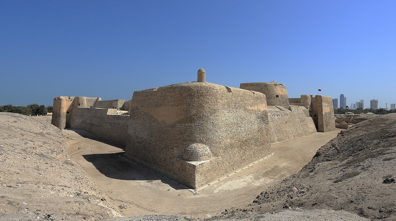
Qal’at al-Bahrain is a tell — an artificial mound formed by successive layers of occupation — on the northern coast of Bahrain island, approximately 5 km northwest of Manama. A UNESCO World Heritage Site since 2005, the mound documents 4,000 years of continuous habitation from the Early Dilmun period around 2300 BCE through the Portuguese colonial occupation of the 16th century CE. It is the site of the ancient capital of Dilmun, a Bronze Age civilisation mentioned in Sumerian cuneiform texts as a major trading intermediary between Mesopotamia and the Indus Valley.
Dilmun: The Bronze Age Trading Hub Between Sumer and the Indus Valley Northern Bahrain coast — 5 km northwest of Manama by road
Dilmun appears in Sumerian texts from the 3rd millennium BCE as a commercial centre and a place of mythological significance. The texts describe it as a source of copper, timber, and luxury goods; merchant records from the city of Ur, dated to approximately 2000 BCE, record imports of copper, ivory, and carnelian from Dilmun, which acted as a re-exporting hub for goods arriving from the Indus Valley (modern Pakistan and northwest India) and the Arabian coast. The Dilmunites did not necessarily produce these commodities themselves — they controlled the transit point and extracted profit from the exchange, much as later the Nabataeans would control the overland incense routes through Petra.
The tell at Qal’at al-Bahrain measures approximately 300 metres by 600 metres and rises to about 12 metres above the surrounding terrain. Excavations — conducted primarily by Danish archaeologists from Aarhus University between 1954 and 1977, and subsequently by Bahraini and French teams — have identified seven successive occupation strata. The earliest, the Early Dilmun period (ca. 2300–1800 BCE), produced the most substantial urban remains: a regularly laid-out city with a grid of streets, large public buildings, and a monumental palace complex in the centre of the tell. The palace underwent multiple rebuilding phases and was still functioning during the Kassite Babylonian occupation (ca. 1500–1000 BCE), when Mesopotamian power extended to the Gulf. Successive layers record Assyrian, Achaemenid Persian, Hellenistic, and Parthian presence, each leaving architectural traces in the stratigraphy.
The Hellenistic occupation, dating to the 4th and 3rd centuries BCE, is documented by Greek pottery and architectural elements consistent with Alexander the Great’s campaigns in the region; his admiral Nearchus sailed through the Gulf on the return journey from India in 325 BCE and described the islands. The Achaemenid level, below it, contains pottery and building techniques characteristic of the Persian Empire under Darius and Xerxes. The site thus functions as a stratigraphic index of Gulf political history across two millennia — each imperial power that controlled the Gulf left material evidence in the Qal’at al-Bahrain mound.
Dilmun’s association with Mesopotamian mythology gives the site a literary dimension unusual among Bronze Age archaeological tells. Sumerian texts describe Dilmun as a “pure, clean, bright land” where sickness does not exist and death is unknown — a paradise in the mythological geography of the ancient Near East. The Epic of Gilgamesh, the oldest surviving literary work, sends its hero to a place identified in later traditions with Dilmun to seek the plant of immortality from Utnapishtim, the Sumerian survivor of the Great Flood (the prototype of the biblical Noah). Utnapishtim is called Ziusudra in the Sumerian version; his story of surviving a divine flood and being granted immortality by the gods was recorded on clay tablets at Nippur around 1700 BCE. Whether the mythological Dilmun corresponds precisely to the archaeological site on Bahrain island has been debated; some scholars have proposed sites on the Saudi Arabian coast or Failaka Island (Kuwait) as alternatives. The UNESCO inscription and the consensus of excavation evidence place the capital of historical Dilmun at Qal’at al-Bahrain.
The Portuguese Fort, the Safavid Capture of 1602 and Bahrain’s Pearl Economy Tell site and fort visible from the coastal road; museum adjacent to the site entrance
The uppermost layer of the Qal’at al-Bahrain tell is a Portuguese fort, built from 1521 onward after the Portuguese established control over the Persian Gulf trade routes under the Estado da India. The Portuguese admiral Afonso de Albuquerque had captured Hormuz at the mouth of the Gulf in 1507, establishing a strategic chokepoint that allowed Portugal to tax maritime trade between the Indian Ocean and the Gulf. Bahrain fell within this network; the fort built on the existing tell was a military installation designed to protect the anchorage and control the local population. The Portuguese occupied Bahrain for 80 years, from 1521 to 1602.
The Safavid Persian Shah Abbas I recovered Bahrain in 1602 with the active assistance of Bahraini Arab and Shia Muslim populations who resisted the Portuguese presence. The capture did not require a major military campaign: the Portuguese garrison was small, the local population provided intelligence and logistical support to the Persian force, and the fort changed hands relatively quickly. The Safavid period on Bahrain lasted until 1783, when the Al Khalifa family — who arrived from the Arabian mainland — established the ruling dynasty that continues today.
The pearl diving economy that surrounded the Qal’at al-Bahrain site represents a separate strand of significance. The natural pearl beds of the Gulf, concentrated in the shallow waters around Bahrain, were among the most productive in the world from ancient times through the early 20th century. Sumerian and Akkadian texts mention pearls from Dilmun; Roman sources describe Gulf pearls as among the most valuable in the Mediterranean world. The pearl diving season ran annually from June through September, when shallow water temperatures were warm enough for sustained diving; men dove to depths of 10–15 metres on a single breath, working cycles of approximately 60 seconds underwater. At the industry’s peak in the 19th century, approximately 30,000 men — nearly the entire adult male population of Bahrain — participated in the annual pearl diving season. The collapse came quickly: Japanese cultured pearls entered the market in the 1930s at a fraction of the price of natural pearls, and the Bahrain oil discovery of 1932 simultaneously provided an alternative economic foundation. The companion UNESCO inscription, Pearling, Testimony of an Island Economy (inscribed 2012), covers 17 sites across Bahrain including former pearl merchants’ houses, a fort, and a section of the historic seashore in Muharraq.
Practical information
Qal’at al-Bahrain is located approximately 5 km northwest of Manama on the northern coast of Bahrain island, accessible by car via the coastal road to Karbabad village. The Bahrain Fort Museum, opened in 2008 adjacent to the site entrance, provides detailed context for the seven occupation layers, with artefacts from the Danish excavations and subsequent work displayed chronologically. The fort walls and the outer perimeter of the tell are freely accessible on foot; the upper Portuguese fort structure can be explored at close range. The site is open daily except Tuesdays; entry is free or low-cost (check current Jordan Tourism Board equivalent — the Bahrain Tourism and Exhibitions Authority manages the site). The best visiting months are October through April, when temperatures are below 30°C; summer heat from June through September makes outdoor site visits uncomfortable in the middle of the day. Manama has a full range of hotels and is served by Bahrain International Airport with direct connections to major European, Asian, and Gulf hubs. The companion UNESCO site, Pearling, Testimony of an Island Economy, is concentrated in Muharraq (across the causeway from Manama) and can be visited on the same day. There are no other UNESCO World Heritage Sites in Bahrain beyond these two inscribed properties.
Frequently Asked Questions
What was the Dilmun civilisation, and how is it connected to Mesopotamian mythology?
Dilmun was a Bronze Age polity centred on Bahrain island and the adjacent Saudi Arabian coast, active as a major commercial force from approximately 3000 BCE to 600 BCE. Its economic role was as a transit hub: goods from the Indus Valley civilisation (copper ingots, carnelian beads, ivory, cotton textiles) and from the Arabian coast (pearls, incense) passed through Dilmun on their way to Mesopotamian cities including Ur, Lagash, and later Babylon. In return, Mesopotamian grain, wool, silver, and manufactured goods moved south. The Dilmunites controlled the water sources and anchorages at the centre of this exchange network and extracted tolls and commissions; they were not primarily producers of the goods they traded. In Sumerian religious literature, Dilmun carries a distinct mythological weight. A text called the Myth of Enki and Ninhursag describes Dilmun as the place where the sun rises, where sickness does not exist, and where death is unknown — a primordial garden landscape. The same tradition places the survivor of the Great Flood, Ziusudra (equivalent to the later Akkadian figure Utnapishtim and the biblical Noah), in Dilmun after the gods grant him immortality. Gilgamesh, searching for eternal life after the death of his friend Enkidu, travels to find Utnapishtim at the end of the world — in later versions of the text, across a sea of death — and receives the plant of immortality, which he subsequently loses to a serpent. The mythological importance of Dilmun as a place of origin, purity, and immortality in Sumerian literature gives Qal’at al-Bahrain a literary significance that goes beyond its archaeological record.
How did the Portuguese control the Gulf, and why did they lose Bahrain in 1602?
Portugal’s strategy in the Indian Ocean and Persian Gulf from 1500 onward was based on controlling strategic chokepoints — Hormuz at the Gulf entrance, Aden at the Red Sea entrance, Goa on the Indian west coast, Malacca on the Malay Peninsula — and taxing all trade that passed through them. Ships that refused to carry Portuguese cartaz (trading licences) were seized or destroyed. The system was effective when Portuguese naval superiority was overwhelming, but it depended on maintaining garrisons at multiple points simultaneously across a vast geographic arc. By the late 16th century, the Portuguese position in the Gulf was overstretched: the garrison at Bahrain was small, the local Shia Muslim population was hostile to Portuguese Catholic rule and taxation, and the Safavid Persian Empire under Shah Abbas I was expanding aggressively westward and southward. The 1602 capture of Bahrain combined Persian military pressure with local assistance; the Portuguese garrison did not receive reinforcements in time and the fort fell. The broader Portuguese position in the Gulf was eroding simultaneously — the Dutch and English East India Companies were beginning to compete for Gulf and Indian Ocean trade, and the Portuguese Estado da India entered a prolonged period of contraction. Bahrain under Safavid rule became a centre of Shia scholarship and agriculture; the pearl diving economy continued and was taxed by the new administration. The Portuguese fort on the Qal’at al-Bahrain tell survived the change of control and was partially modified by later occupants.
What was the natural pearl diving industry of Bahrain, and what ended it?
The natural pearl beds of Bahrain were formed in the shallow, warm, low-salinity waters of the Gulf where freshwater springs well up from the seabed — conditions that favour the production of pearls by the pearl oyster Pinctada radiata. The oysters were harvested by divers working from traditional wooden dhows called jahazis and sambuks during the annual pearl season from June to September. Divers operated in teams: a haul man (siyb) on the surface managed the rope; a diver (ghais) clipped a nose peg, hung a stone weight around his neck to sink quickly, and descended to the seabed collecting oysters by hand into a mesh bag before the rope was pulled to signal his return. Experienced divers could complete 50 to 60 dives per day. The oysters were opened on board; the vast majority contained nothing, while a small fraction produced pearls of varying quality. The industry was highly stratified: boat captains, pearl merchants (tawawish), and the Bahraini ruling family took the major shares of profit; divers were paid by complex advance systems that often left them in permanent debt to the boat captain. The end came with remarkable speed. Kokichi Mikimoto’s cultured pearl technique — inserting an irritant nucleus into a farmed oyster to stimulate pearl production — was perfected in Japan by the 1920s and entered export markets in quantity by 1930. Cultured pearls were visually indistinguishable from natural ones and cost a fraction of the price. The Bahrain natural pearl market collapsed within a decade. The 1932 discovery of oil provided an alternative economy; by 1940, natural pearl diving in Bahrain had effectively ceased as a commercial enterprise.
Sources
- S1 — Bahrain Authority for Culture and Antiquities (BACA) — Qal'at al-Bahrain Ancient Harbour & Fort — https://culture.gov.bh/
- S2 — Flemming Højlund & H. Hellmuth Andersen — Qala'at al-Bahrain: The Northern City Wall and the Islamic Fortress, Jutland Archaeological Society, Moesgaard, 1994, ISBN 978-8772885773
Spotted an error? Write to editorial@culturalheritageonline.com and we correct it the same day.