Brimstone Hill Fortress on Saint Kitts took a century to build, was defended by a thousand men against a French fleet for a month in 1782, and was constructed almost entirely by enslaved African labourers who left no names in the colonial record. UNESCO inscribed it in 1999 as the best-preserved example of 17th and 18th-century British colonial military architecture in the Americas.
A Volcanic Platform Turned Into a Command Post Saint Kitts, 14 km northwest of Basseterre
Saint Kitts — Saint Christopher — is one of the smaller islands of the Lesser Antilles, roughly 176 km² in area, shaped by a chain of volcanic peaks running northeast to southwest. Brimstone Hill rises 240 metres above the northwest coast of the island, a plug of volcanic basalt that early British settlers recognised immediately as the most defensible terrain on Saint Kitts. The hill sits 14 km northwest of the capital Basseterre and commands views across the Narrows Channel to the island of Nevis and, in clear conditions, east to Sint Eustatius and north toward Saint Barths.
The British began fortifying Brimstone Hill in 1690, following the French capture of much of Saint Kitts the previous year. The project continued intermittently for a century, driven by the strategic importance of the island as a sugar-producing colony and by the persistent Franco-British competition for control of the eastern Caribbean. Construction relied on the labour of enslaved Africans who quarried the dark volcanic stone on the hill itself, shaped it, and raised the walls without the mechanical assistance that would have been applied to fortifications in Europe. The workforce left almost no documentary trace — the colonial records name the British engineers and officers who directed the work, not the people who built it.
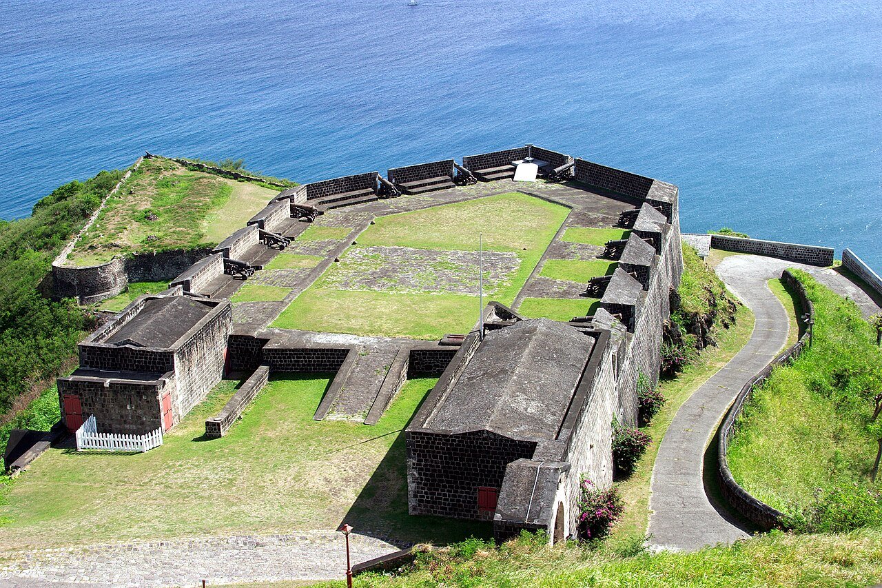
The completed fortress system covered approximately 15 acres across several defensive tiers. The uppermost level, Fort George Citadel, commanded the approaches from all sides. Below it, a series of outworks, batteries, and a magazine formed a layered defence intended to absorb an assault that broke through the outer perimeter. The walls are 2–3 metres thick in the most exposed sections, built in the polygonal trace style that European military engineers had developed to deflect cannon fire. The construction quality was good enough that much of the main structure survives largely intact today, more than 330 years after the first stones were laid.
The Caribbean context for Brimstone Hill is defined by absence as much as proximity. Saint Kitts and Nevis, as twin-island nations, hold no other UNESCO World Heritage Sites. The nearest inscribed sites are Willemstad in Curaçao, approximately 600 km to the southeast, and the Historic Bridgetown and its Garrison in Barbados, roughly 450 km southeast. Both Willemstad and Bridgetown Garrison represent different colonial traditions — Dutch mercantile urbanism and British military infrastructure respectively — and neither is reachable as a day trip. Brimstone Hill occupies its heritage geography alone: the most significant surviving monument to the British colonial presence in the eastern Caribbean, on one of the smallest islands to hold a UNESCO World Heritage inscription anywhere in the world.
The Siege of 1782, the Treaty of 1783, and the Green Monkeys That Inherited the Ramparts Fort George Citadel and outer batteries
The most dramatic episode in Brimstone Hill’s history came in February 1782, when a French fleet under the Comte de Grasse — fresh from a string of victories across the Caribbean — arrived off Saint Kitts with approximately 8,000 troops. The British garrison inside Brimstone Hill numbered roughly 1,000: a mix of regulars, militia, and refugees from the lowland settlements who had retreated to the fortress as the French landed. The garrison was commanded by General Thomas Fraser and was significantly outnumbered.
The French established siege lines around the base of the hill and began a methodical bombardment. The British resisted for just over a month — from 11 January to 13 February 1782 — a defence that drew contemporary admiration even from the French commanders. When Fraser finally surrendered, he was granted full military honours: the garrison marched out with their arms, drums beating and flags flying, in recognition of the quality of the defence. The fortress fell, but the resistance had delayed the French long enough for other British forces in the region to regroup.
The French occupation lasted less than two years. Under the Treaty of Paris of 1783, Saint Kitts was returned to Britain. The fortress was repaired and garrisoned again, remaining in British military use until 1853, when the declining strategic importance of the Caribbean colonies and the cost of maintaining the installation led to its abandonment. The garrison departed, and the fortress was left to the elements and the local population, who quarried some of the stone for building material in subsequent decades.
The site was gazetted as a national park in 1985 and received UNESCO inscription in 1999. Careful restoration has stabilised the main structures without reconstructing what has been lost. The Fort George Citadel is the centrepiece: the magazine, the barracks, the officers’ quarters, and a cannon battery survive in conditions that allow the spatial logic of the fort to be read clearly. From the upper ramparts the view extends across the channel to Nevis and south along the Saint Kitts coastline, with the sugar plantation country visible below — the landscape whose defence the fortress was ultimately built to protect.
The fortress grounds are now shared with a population of vervet monkeys — green monkeys in the local terminology — descendants of animals brought to the Caribbean from West Africa in the 17th century, most likely as pets on slave ships. The population on Saint Kitts has been established for over three centuries and has adapted completely to the volcanic scrub habitat. They are a visible presence throughout the fortress grounds, particularly in the early morning before visitor numbers increase. Their presence is a reminder that the colonial ecological exchange — the movement of species across the Atlantic alongside the movement of enslaved people, trade goods, and disease — transformed Caribbean environments as thoroughly as it transformed Caribbean societies.
Practical information
Brimstone Hill Fortress National Park is located on the northwest coast of Saint Kitts, 14 km from the capital Basseterre. The Robert L. Bradshaw International Airport is adjacent to Basseterre; most visitors arrive by air via Antigua, Puerto Rico, or Miami. The fortress is accessible by car or taxi from Basseterre in approximately 20–25 minutes. The road up to the fortress entrance involves a short but steep final climb.
The park is open daily from 9:30 to 17:30. Admission is charged; the fee includes access to the museum at Fort George Citadel, which covers the history of the fortress, the siege of 1782, and the role of enslaved labour in its construction. Allow two to three hours for a thorough visit including the outer batteries and the views from the upper rampart.
Saint Kitts has a dry season from December to April and a wetter season from July to November, with September and October the most active months for tropical systems. The island is small enough to tour in a single day, and most cruise passengers who call at Basseterre include Brimstone Hill as a standard shore excursion. Independent travellers staying on the island can combine the fortress visit with the Romney Manor botanical gardens nearby and the black sand beaches of the northwest coast.
Frequently Asked Questions
What makes Brimstone Hill Fortress significant enough for UNESCO inscription?
The UNESCO inscription in 1999 cited Brimstone Hill as an outstanding example of European colonial military architecture adapted to Caribbean volcanic terrain. The fortress is significant for three overlapping reasons. First, its physical integrity: the main structures survive in a state of preservation unusual for a site that was abandoned in 1853 and has never been heavily reconstructed. The walls, the magazine, the barracks, and the cannon batteries are legible as a functioning defensive system rather than a ruin. Second, its historical importance: the fortress was the primary British military installation in the eastern Caribbean during the critical period of Franco-British competition for colonial dominance, from the late 17th to the early 19th century. The 1782 siege was one of the more significant engagements of the American Revolutionary War’s Caribbean theatre and directly influenced the diplomatic negotiations at the Treaty of Paris. Third, its human history: the fortress was built over a century almost entirely by enslaved African labour, making it a material record of the colonial forced-labour economy even though the individuals who built it are largely unnamed in the historical record. UNESCO’s inscription recognised all three dimensions.
How does Brimstone Hill compare to other Caribbean UNESCO fortifications like Bridgetown Garrison?
The Historic Bridgetown and its Garrison in Barbados, inscribed in 2011, and Brimstone Hill in Saint Kitts represent different phases and functions of British Caribbean military infrastructure. Bridgetown Garrison was the headquarters of the British forces in the Windward and Leeward Islands and operated as an administrative and logistical centre; the surviving buildings include barracks, a clock tower, and institutional structures that make it read more like a military town than a combat fortification. Brimstone Hill, by contrast, is a combat fort — designed to receive siege and to resist assault. Its polygonal basalt walls, its tiered defensive system, and its elevated position on a volcanic plug have no parallel at Bridgetown. The Willemstad inscriptions in Curaçao (1997) represent a third tradition: Dutch mercantile urbanism with a fortified harbour, where the defensive function was secondary to the commercial one. For visitors interested specifically in military architecture, Brimstone Hill is the most technically complete example of colonial-era fort construction in the eastern Caribbean, and arguably in the wider Atlantic world outside the major European metropolitan examples.
What role did enslaved people play in building Brimstone Hill, and how is this acknowledged at the site?
Brimstone Hill was constructed almost entirely by enslaved African labourers under British military direction across a period of roughly a century, from 1690 to 1790. The work involved quarrying the dark volcanic basalt on the hill itself — the stone was hewn from the hill’s own substrate — transporting it within the site, and raising walls up to 3 metres thick in the most exposed positions. The physical difficulty of this labour, on a steep volcanic hilltop in tropical heat without mechanical lifting equipment, is considerable. Colonial records from the period name the British engineers, the officers, and the political figures who funded and directed the construction. They do not, in general, record the names of the enslaved workers. The site museum at Fort George Citadel addresses this directly: one of the exhibition themes covers the labour history of the fortress and acknowledges that the monument’s physical survival is inseparable from the coerced work of people who left no individual record. This is a relatively recent development in how heritage institutions interpret colonial military sites, and Brimstone Hill’s approach reflects the wider shift in Caribbean heritage interpretation since the early 2000s toward confronting the enslaved-labour economy that financed and built the plantation colonies these fortresses were built to protect.