
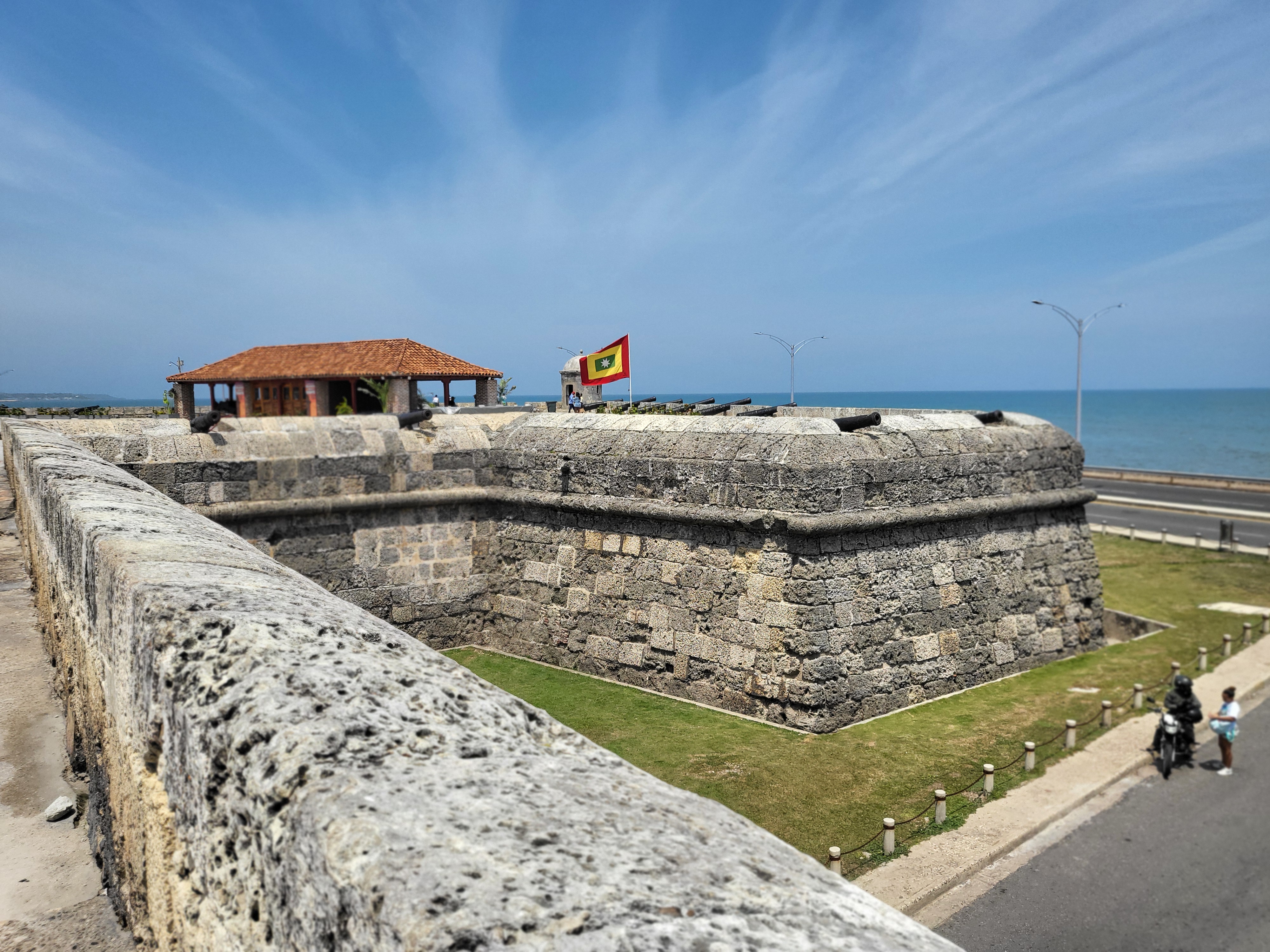
Colombia concentrates four UNESCO World Heritage Sites within reach of Bogotá, ranging from a 16th-century Caribbean fortress city to pre-Columbian painted burial chambers hidden beneath Andean hillsides. Each represents a distinct chapter in the country’s layered history. From Cultural Heritage Online.
Coffee Cultural Landscape of Colombia 180–280 km west · 3–5 hr by road or 1 hr by flight
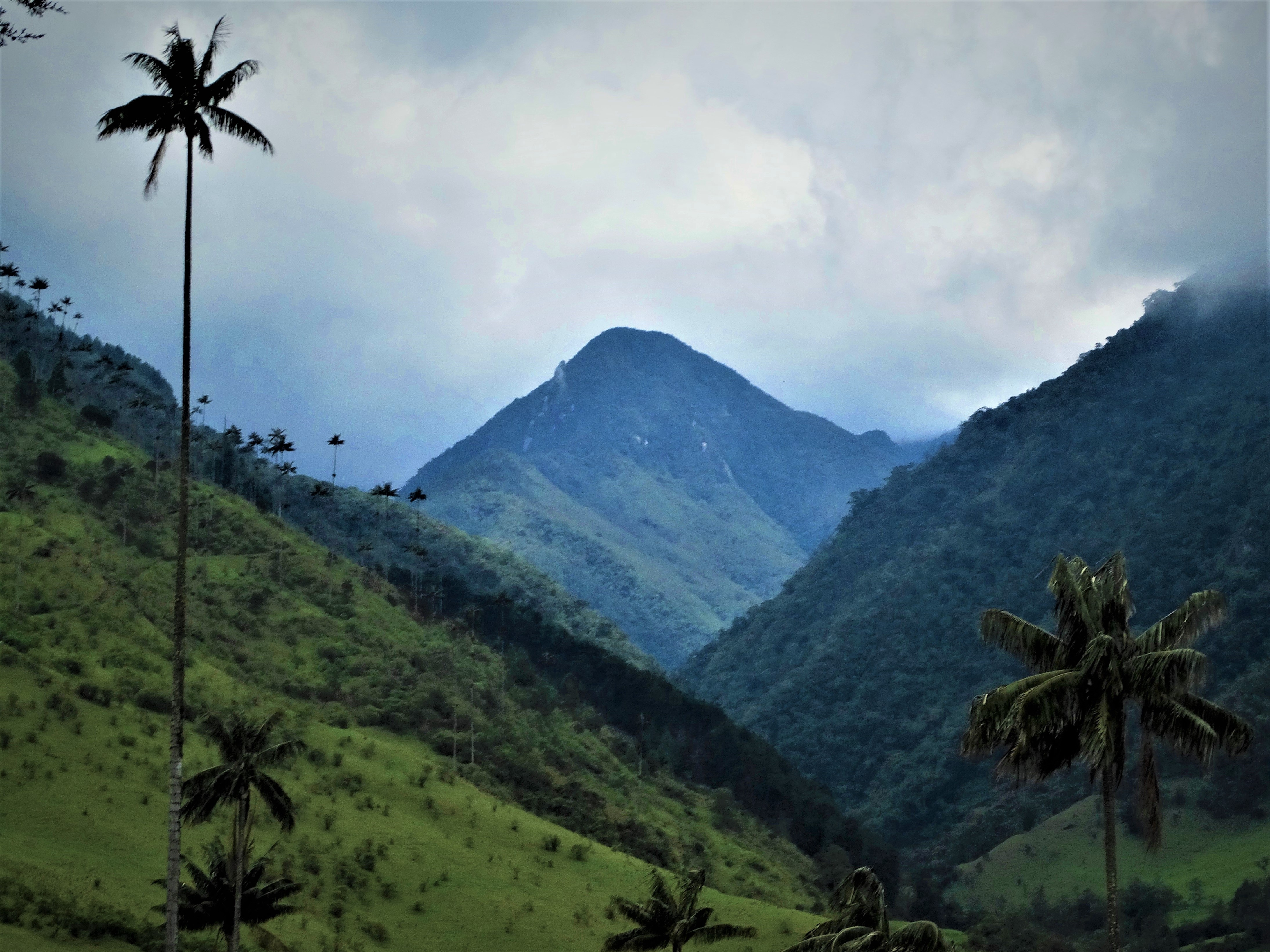
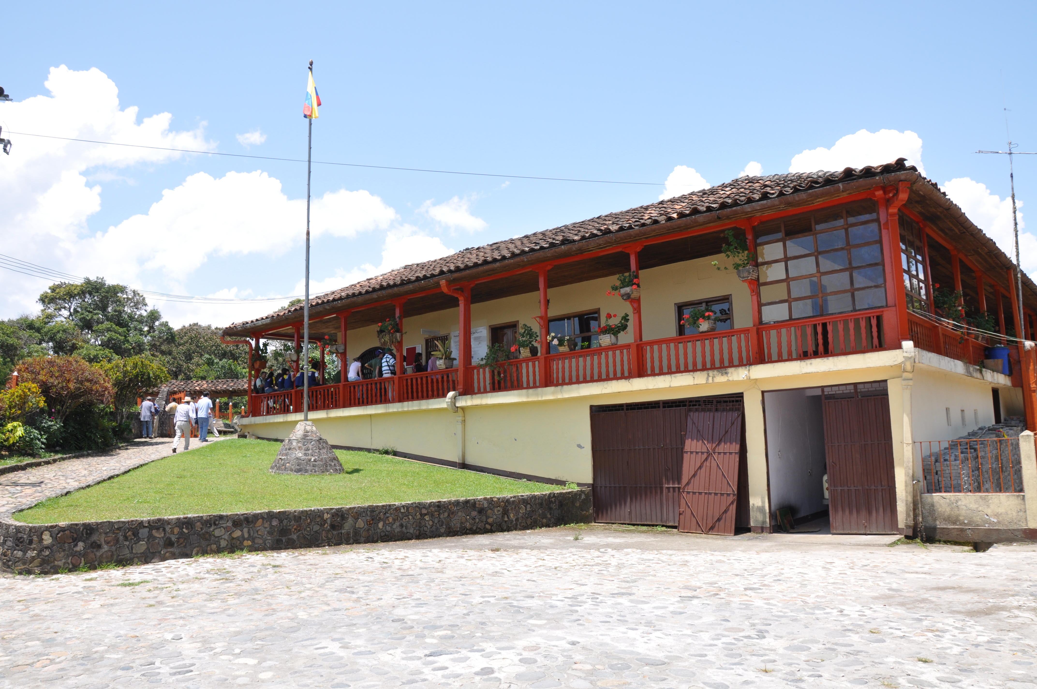
Inscribed in 2011, the Coffee Cultural Landscape covers six clusters of municipalities across the departments of Caldas, Risaralda, Quindío, and Valle del Cauca — collectively known as the Eje Cafetero. UNESCO recognised it as an outstanding example of a living cultural landscape: one shaped by more than a century of coffee cultivation, where the economy, architecture, and social fabric remain inseparable from the crop. Traditional fincas cafeteras — farmsteads with bahareque (bamboo and mud) construction, vivid painted facades, and colourful timber balconies — dot the steep slopes between rows of coffee plants and stands of banana.
The Cocora Valley, near Salento, gives the landscape its most striking image. Quindío wax palms — Colombia’s national tree and the tallest palm species in the world, reaching up to 60 metres — stand in isolated clusters across open grassland, their slender trunks disappearing into the cloud layer. The combination of volcanic soil, altitude, and the humid microclimate of the Andes produces the conditions for the mild, aromatic washed arabica coffee that defines the region’s international reputation.
Getting there: Drive or take a bus to Armenia (280 km) or Pereira (235 km); direct domestic flights from Bogotá El Dorado take under an hour. Allow: 2–3 days to visit a working finca, walk the Cocora Valley, and explore the towns of Salento or Filandia. Best for: Travellers who want to combine culture, coffee tasting, and Andean hiking.
Archaeological Park of Tierradentro 350 km southwest · 7–8 hr by road
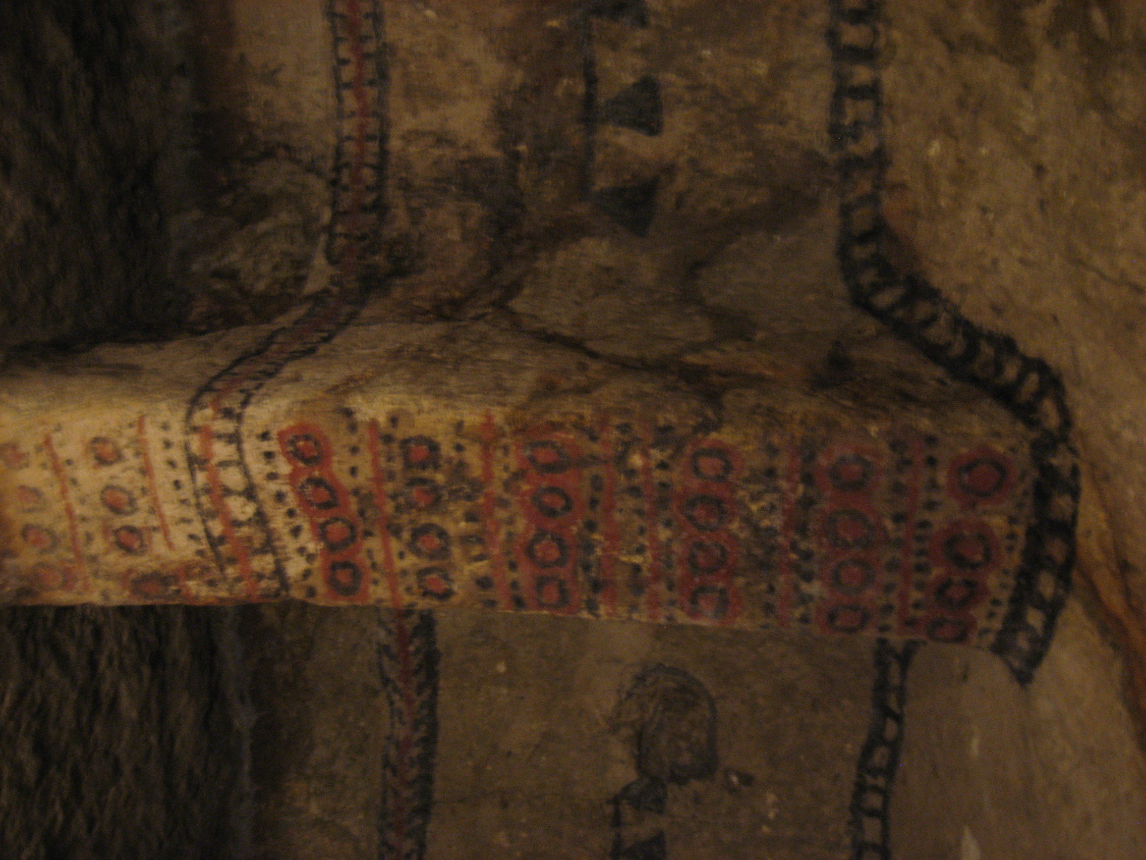
Inscribed alongside San Agustín in 1995, Tierradentro contains more than 100 pre-Columbian underground burial chambers cut into the hillsides above the Ullucos River valley in the department of Cauca. The hypogea — each entered by a spiral staircase and ranging from two to nine metres in depth — were excavated between approximately 500 and 900 AD by a culture that archaeologists still refer to by the site’s geographic name. Inside, the walls and domed ceilings carry geometric paintings in red, black, and white: spirals, zigzags, and stylised human faces rendered in mineral pigments that have survived more than a millennium underground.
The chambers served secondary burial: bones of the dead were cleaned, rearranged, and redeposited here, accompanied by gold ornaments and ceramic vessels. The largest hypogea could hold multiple individuals. Standing inside one, with a kerosene lamp illuminating the painted ceiling a metre above your head, the scale of the labour involved is tangible — each chamber required the removal of tonnes of soil by hand, through an opening barely wide enough for a body.
Getting there: Drive or take a bus via Popayán to San Andrés de Pisimbalá (the gateway village); the journey from Bogotá takes 7–8 hours on winding mountain roads. Guided access to the hypogea is obligatory and managed on-site. Allow: 1 full day minimum; 2 days to visit all five archaeological zones. Best for: Archaeological travellers and anyone interested in pre-Columbian funerary art.
San Agustín Archaeological Park 380 km south · 7–8 hr by road
San Agustín holds the largest concentration of pre-Columbian funerary monuments in South America. Over 500 stone statues — carved from single blocks of volcanic andesite and standing up to four metres tall — guard burial mounds scattered across a mountain plateau at 1,700 metres in the department of Huila. The Agustín culture produced them between the 1st and 8th centuries AD: figures with jaguar fangs, bulging eyes, and elaborate headdresses that blend human and animal features in a way archaeologists interpret as representations of funerary deities or shaman-warriors presiding over the dead.
The statues are distributed across a series of mesitas (flat-topped hills) connected by paths through tropical forest. Some remain in their original positions above burial mounds; others have been relocated to museum compounds on-site. The setting — cloud-forested ridges above the gorge of the Magdalena River, Colombia’s main interior waterway — gives the park a dramatic geographic context that reinforces its UNESCO designation as an exceptional testimony to a vanished civilisation.
Getting there: Drive via Neiva or take a bus to the town of San Agustín in Huila. Roads are paved but slow; allow 7–8 hours from Bogotá. Alternatively, fly to Neiva (40 min) and continue by road (2–3 hr). Allow: 2 days to cover the main mesitas and the Fuente de Lavapatas (a carved ceremonial fountain). Best for: Those with a strong interest in South American archaeology; pairs well with a Tierradentro visit on a southern Colombia loop.
Port, Fortresses and Group of Monuments, Cartagena 1,000 km north · 2 hr by flight
Cartagena de Indias became Spain’s primary Caribbean trading port in the 16th century, and the city’s UNESCO inscription (1984) encompasses both its colonial urban fabric and the military architecture built to defend it. The Castillo de San Felipe de Barajas, completed in its current form in 1762, is the largest Spanish fortification ever constructed in the Americas. Its angled bastions, underground tunnels, and glacis slopes were engineered to defeat any artillery assault from sea or land; the fortress still dominates the hill above the city.
Within the walled old town, the architecture compresses three centuries of colonial building into a few square kilometres: Baroque churches, merchants’ mansions with overhanging carved wooden balconies draped in bougainvillea, and cobbled plazas where the afternoon light turns the painted facades — ochre, gold, terracotta — particularly vivid. The city walls themselves, up to fifteen metres thick in places and encircling the entire historic core, give Cartagena an urban coherence that most colonial-era cities lost to 19th-century expansion.
The surrounding Caribbean coast and islands (the Rosario Islands, 45 minutes by boat) make Cartagena viable as a longer stay rather than a single-day excursion — which given the 2-hour flight from Bogotá is the realistic minimum commitment.
Getting there: Domestic flights from Bogotá El Dorado to Cartagena Rafael Núñez Airport operate frequently throughout the day (approx. 2 hours). Road travel is 20+ hours and not practical for most visitors. Allow: 2–3 nights to cover the old city, the castle, and at least one day on the water. Best for: First-time visitors to Colombia and anyone combining cultural heritage with a Caribbean stay.
Frequently Asked Questions
How many UNESCO World Heritage Sites are near Bogotá?
Four UNESCO World Heritage Sites are accessible from Bogotá. The Coffee Cultural Landscape of Colombia (inscribed 2011) lies 180–280 km west. The Archaeological Park of Tierradentro (1995) and San Agustín Archaeological Park (1995) are both in the south of the country, 350–380 km by road. Cartagena’s Port, Fortresses and Group of Monuments (1984) is 1,000 km to the north, best reached by a 2-hour domestic flight.
How do you get from Bogotá to the Coffee Cultural Landscape?
The most convenient access points are Armenia (served by El Edén Airport, about 1 hour by domestic flight) and Pereira (Matecaña Airport, also around 1 hour). Overland by bus or car, the drive to Armenia takes 4–5 hours via the Honda–Ibagué route or the toll road through the Quindío mountains. From either city, the Cocora Valley and the town of Salento are less than 45 minutes by road.
What is the best time of year to visit these sites?
Colombia straddles the equator and has no single dry season nationwide, but most of the sites around Bogotá are best visited during the two drier periods: December–February and June–August. The Coffee Region is lush year-round, though October and November bring heavy rains to Quindío and Risaralda. Cartagena’s Caribbean climate makes it hotter and more humid in rainy season (May–November), but the old city is accessible year-round. San Agustín and Tierradentro, at higher altitudes, are cooler and can see afternoon rain showers throughout the year.
What makes Tierradentro’s hypogea archaeologically significant?
The Tierradentro hypogea are among the few large-scale pre-Columbian underground burial chambers in the world that retain their original painted decoration. The geometric murals — applied in red, black, and white mineral pigments — survive because the chambers were sealed after use and undisturbed for over a millennium. The secondary burial practice they document, in which bones were exhumed, ritually prepared, and reinterred in elaborately decorated underground spaces, has no close parallel elsewhere in the Americas at this scale. Together with San Agustín, Tierradentro demonstrates a sophisticated funerary culture that flourished in the Colombian Andes between the 5th and 9th centuries AD, and then disappeared before Spanish contact.



.jpg)