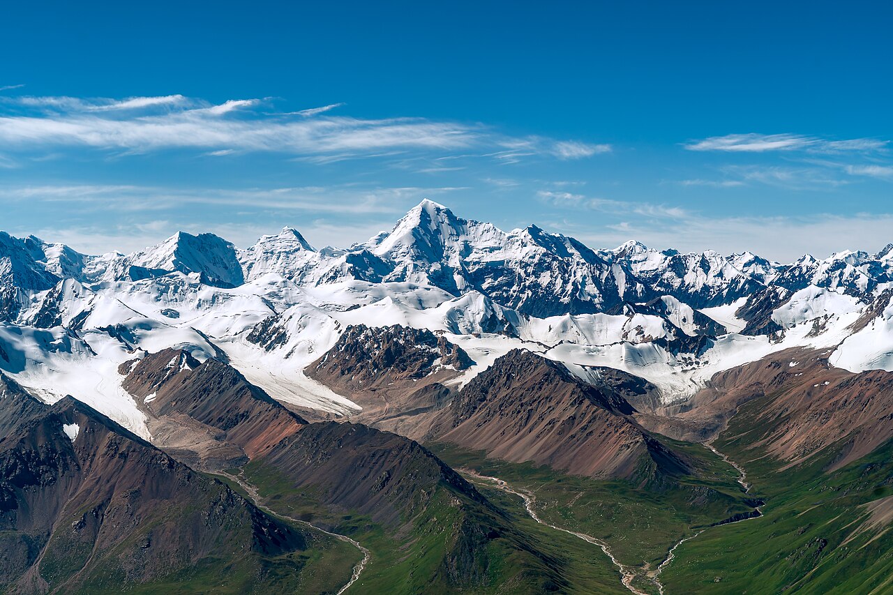
The Xinjiang Tianshan, inscribed by UNESCO in 2013, encompasses four separate protected areas totalling 606,833 hectares in the Tianshan (天山, “Heavenly Mountains”) mountain range in Xinjiang Uyghur Autonomous Region of northwestern China — the Chinese section of the Central Asian mountain system that extends 2,500 kilometres from eastern Uzbekistan through Kyrgyzstan and Kazakhstan to western China. The four inscribed components (Tomur, Kalajun-Kuerdening, Bayinbuluke, and Bogda) represent the eastern Tianshan’s major landscape zones: the highest peak zone at Tomur (Tuomuer Peak, 7,443 metres, the highest point of the Tianshan range and the second-highest peak in China after Gongga Mountain), the alpine grassland and lake zone at Bayinbuluke (the Bayanbulak Swan Nature Reserve, the largest inland wetland in China, at 2,500 metres altitude), the glacier and alpine scenery of Kalajun-Kuerdening, and the accessible Bogda sub-range east of Ürümqi (Bogda Peak, 5,445 metres, with the Tianchi Heaven Lake, 1,928 metres altitude, a glacially formed alpine lake 110 kilometres east of Ürümqi). The inscription’s Outstanding Universal Value rests on the Xinjiang Tianshan’s exceptional representation of the full geological and ecological sequence of a temperate arid-zone mountain system: from the high alpine desert and glacial zone (above 3,500 metres) through the alpine grassland (2,000–3,500 metres), the forest belt of Tian Shan spruce (Picea schrenkiana, endemic to Central Asian mountain ranges, 1,500–2,800 metres), the juniper and fruit forest zone (800–1,500 metres), to the desert steppe at the mountain base (below 800 metres) — each zone representing a separate ecosystem maintained by the Tianshan’s orographic effect on the Central Asian arid climate.
Central Asian mountain heritage: Silk Road corridors and nomadic landscapes Silk Roads Chang’an-Tianshan · Jiaohe Ancient City Turpan · Mogao Caves Dunhuang — 100 to 700 km
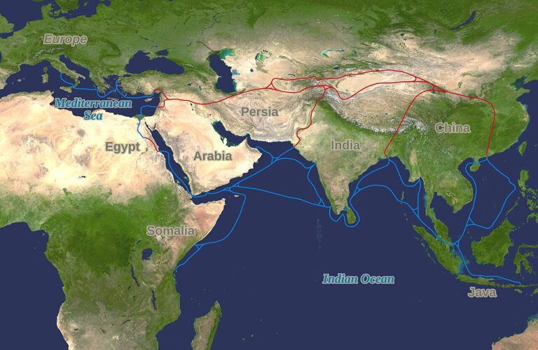
One Hundred Kilometres east of the Xinjiang Tianshan’s Bogda component by road (approximately 1.5 hours from the Tianchi Heaven Lake to Ürümqi City, and then approximately 1.5 hours by the Lan-Xin High-Speed Railway or the Ürümqi-Turpan Expressway south to Turpan City), Turpan Basin contains the Jiaohe Ancient City (交河故城, Jiaohe Gucheng), the Gaochang Ancient City (高昌故城, Gaochang Gucheng), and the Bezeklik Thousand Buddha Caves (柏孜克里克千佛洞, Bézèklik Qiān Fú Dòng) — all three components of the Silk Roads: the Routes Network of Chang’an-Tianshan Corridor inscription (2014), listed under the Chinese section of the transnational Silk Roads serial inscription. Jiaohe is a 2,000-year-old city built on a naturally fortified plateau between two converging rivers (the ‘T’-shaped plateau providing natural defensive walls on three sides), occupied from the 2nd century BCE through the 14th century CE and abandoned after the Mongol conquest — it is the largest and best-preserved example of an earthen city from the ancient Silk Road urban network in China. Turpan Basin lies at −154 metres below sea level (the second-lowest depression on earth after the Dead Sea), and its karez (坎儿井, qanat) irrigation system — approximately 3,000 underground irrigation channels totalling more than 5,000 kilometres, constructed over 2,000 years to bring snowmelt from the Tianshan peaks to the Turpan farmland without surface evaporation losses — is one of the great hydraulic engineering achievements of Central Asian civilisation. From the Xinjiang Tianshan’s Bogda component (Tianchi Heaven Lake), Turpan is reached by the Lan-Xin HSR (approximately 45 minutes from Ürümqi South to Turpan North Station) or by expressway (approximately 2 hours).
Seven Hundred Kilometres east of the Xinjiang Tianshan by road and rail (approximately 10 hours from Ürümqi by conventional rail to Dunhuang, or approximately 6 hours by the Lan-Xin and Hexi Corridor HSR to Jiayuguan North, then coach 2 hours to Dunhuang), the Mogao Caves (莫高窟, Mògāo Kū, Dunhuang, Gansu Province, inscribed 1987) are the most important Silk Road Buddhist site in China and the western terminal of the cultural heritage corridor that the Silk Roads inscription (2014) documents. The Mogao Caves’ 492 decorated cave chambers (the largest surviving collection of Buddhist painted murals in the world — approximately 45,000 square metres of wall painting spanning the Northern Wei through Yuan periods, 4th–14th centuries CE) represent the full iconographic history of Central Asian and Chinese Buddhist art over 1,000 years, maintained by the desiccating climate of the Gobi Desert that preserved the organic pigments in the cave murals. The Dunhuang oasis — the point where the northern and southern Silk Road branches rejoined before entering the Gansu Corridor eastward — was the primary Buddhist cultural production centre on the Chinese Silk Road, receiving pilgrims, monks, merchants, diplomats, and soldiers from China, India, Central Asia, and the Iranian plateau whose mixed cultural presence is documented in the cave murals’ iconographic eclecticism (Indian, Gandaharan, Sassanid Persian, Sogdian, Chinese, and later Tibetan and Mongol artistic traditions coexist in the same cave complex). From Ürümqi, Dunhuang is reached by the Lan-Xin HSR to Liuyuan Station (approximately 8 hours) and then coach (approximately 1.5 hours); or by daily flight from Ürümqi Diwopu Airport to Dunhuang Airport (approximately 1.5 hours).
Two Hundred Kilometres northwest of the Xinjiang Tianshan across the international border (approximately 6 hours by road from the Chinese Tomur peak area to Almaty, Kazakhstan, via the Almaty-Korgos highway, crossing at the Khorgos border) or approximately 4 hours from Ürümqi to Almaty by flight (Ürümqi Diwopu International Airport serves multiple Almaty flights per day), Kazakhstan hosts two of the serial Silk Roads inscription’s Central Asian components (the Talgar, Kayalyk, and Akyrtas sites in Zhetysu Oblast) and the Saryarka Steppe and Lakes of Northern Kazakhstan inscription (2008). The geographic proximity of the Chinese Xinjiang Tianshan and the Kazakh sections of the Tianshan (which are inscribed as a separate UNESCO World Heritage Site — the Tianshan UNESCO inscription spans both the Chinese and Central Asian sections of the range, though the Kyrgyz and Kazakh sections were nominated separately by their respective governments) makes a cross-border circuit possible for visitors with appropriate Central Asian visas. From Ürümqi, Almaty is reached by daily air service (approximately 2 hours) or by overland transit through the Khorgos border crossing (approximately 6 hours total road journey). The Kazakh steppe and Kyrgyz Tien Shan landscapes on the western side of the Tianshan range offer the same mountain ecology with different cultural context — nomadic Kazakh and Kyrgyz pastoral cultures rather than Chinese Han-Uyghur settled agricultural culture.
Within the Xinjiang Tianshan inscription, the most visitor-accessible component is the Bogda sub-area east of Ürümqi (the Tianchi Heaven Lake scenic area, 110 km east of Ürümqi, accessible by tourist bus from the Ürümqi North Train Station in approximately 2 hours). The Bayinbuluke Swan Nature Reserve (the largest Bayanbulak component, approximately 600 km west of Ürümqi by road, or approximately 1 hour by flight from Ürümqi to Korla and then 3 hours by road) is the second most visited component and the recommended destination for birdwatchers (the reserve is China’s primary wintering ground for Whooper Swans, Bewick’s Swans, and the endangered Black-necked Crane, with peak numbers in October–November). The Tomur and Kalajun-Kuerdening components (approximately 700 km southwest of Ürümqi near the Kyrgyz border) require 4WD transport and are suitable primarily for organised mountaineering and trekking expeditions. Ürümqi Diwopu International Airport is the primary gateway, with direct flights from Beijing (approximately 3 hours), Shanghai (approximately 5 hours), and major Central Asian cities.
The Xinjiang corridor: desert heritage and mountain ecology Turpan Silk Road sites · Kuqa Buddhist caves · Kanas Lake nature reserve — 100 to 700 km
Five Hundred Kilometres west of Ürümqi along the northern Silk Road corridor by road and rail (approximately 8 hours by conventional train from Ürümqi to Kuqa/Aksu, or approximately 4 hours by the Southern Xinjiang Railway when upgraded), Kuqa (库车, Kùchē, the ancient Kucha kingdom) contains the Kizil Thousand Buddha Caves (克孜尔千佛洞, the oldest and westernmost Buddhist cave complex in China, with approximately 236 numbered caves dating from the 3rd to 8th centuries CE) and the Subash Buddhist Ruins (苏巴什佛寺遗址). The Kizil Caves’ paintings — which predate the Dunhuang murals chronologically and show stronger Iranian and Indian artistic influences than the Chinese Silk Road cave complexes further east — are the westernmost expression of the Buddhist artistic tradition in China and the physical record of Buddhism’s transmission route from India through Central Asia to China. The Kizil Caves were significantly damaged by German expeditions in the early 20th century (Albert Grünwedel’s and Albert von Le Coq’s 1902–1914 expeditions removed approximately 450 square metres of wall paintings to the Museum für Asiatische Kunst in Berlin, where portions survive today); the remaining in situ paintings demonstrate the original artistic quality and iconographic scope of the Central Asian Buddhist painting tradition that the Dunhuang caves represent at its Chinese eastern terminus.
Practical information
The Xinjiang Tianshan World Heritage Site comprises four separate components distributed across the Xinjiang Uyghur Autonomous Region: Tomur (near Aksu City, approximately 700 km southwest of Ürümqi), Kalajun-Kuerdening (near Yili/Ili prefecture, approximately 700 km west-northwest of Ürümqi), Bayinbuluke (near Bayingol prefecture, approximately 600 km southwest of Ürümqi), and Bogda (110 km east of Ürümqi, the most accessible). Ürümqi Diwopu International Airport (URC) is the primary gateway, with domestic flights from Beijing (approximately 3 hours), Shanghai (approximately 5 hours), Chengdu (approximately 3.5 hours), and Guangzhou (approximately 5 hours), and international connections to Almaty, Tashkent, Bishkek, Dubai, and Moscow. The Lan-Xin High-Speed Railway (Lanzhou to Ürümqi, the world’s longest high-speed railway through a desert zone, 1,776 km, opened 2014) provides high-speed rail access from Lanzhou (approximately 5.5 hours), Xi’an (approximately 8.5 hours), and Zhengzhou (approximately 12 hours). For the Bogda (Tianchi Heaven Lake) component, tourist buses from Ürümqi North Station run April–October (approximately 2 hours each way); a one-day visit includes the cable car to the lake shore and the 1.5-kilometre lakeside walking circuit. The Bayinbuluke Swan Reserve is visited April–October (peak bird numbers September–November); access from Korla City by road (approximately 3 hours) or from Ürümqi by domestic flight to Korla (approximately 1 hour) and road transfer. Altitude at the inscription’s higher elevations (Tomur base camp approximately 3,500 metres; Bayinbuluke plateau approximately 2,500 metres) requires acclimatisation for visitors travelling directly from low-altitude Chinese cities. Permits for the more remote components (Tomur, Kalajun) require advance arrangement through Xinjiang Tourism Bureau-registered agencies.
Frequently Asked Questions
What is the significance of the Tianshan mountain range in Central Asian history and culture?
The Tianshan (天山, “Heavenly Mountains” in Chinese; Tengri-Tag in Turkic, “Mountains of the Sky God”) is the mountain range that has historically divided Central Asia into its two primary ecological and cultural zones: the northern steppe (the Eurasian grassland belt occupied by nomadic pastoral peoples from the Scythians through the Mongols) and the southern oasis zone (the Tarim Basin and Fergana Valley oases where sedentary agricultural and urban civilisation developed around Silk Road trade). The Tianshan’s role as a geographic dividing line made it a culturally and economically significant corridor: the passes through the Tianshan (the Torugart Pass between Xinjiang and Kyrgyzstan, the Bedel Pass, the Muzart Pass, and the Ili Valley corridor) were the primary crossing points between the northern nomadic world and the southern sedentary world, and therefore the routes through which the Silk Road’s goods, religions, languages, and peoples moved between China, Central Asia, Iran, and the Mediterranean. The Xinjiang Tianshan’s four inscribed components represent different aspects of this geographic role: the Tomur peak zone (the Tianshan’s highest point, the Tengri-Tag of Turkic cosmology, the sacred mountain of the sky god that defined the cosmological horizon for Central Asian nomadic cultures) documents the sacred landscape dimension; the Bayinbuluke Swan Reserve (the summer grazing ground for Kazakh, Kyrgyz, and Mongolian pastoral communities for at least 2,000 years) documents the pastoral ecology dimension; and the Bogda sub-range (the Tianshan sub-range immediately visible from the Chinese oasis cities of Ürümqi and Turpan) documents the mountain’s role as the ecological boundary that made the Xinjiang oasis cities agriculturally viable by providing snowmelt irrigation water via the karez systems.
What is the Heaven Lake of Tianshan (Tianchi) and why has it been a cultural landmark for so long?
Tianchi (天池, “Heaven Pool/Lake”) is a glacially formed alpine lake at 1,928 metres altitude in the Bogda sub-range of the Tianshan, approximately 110 kilometres east of Ürümqi, within the inscribed Bogda component of the Xinjiang Tianshan World Heritage Site. The lake occupies a cirque valley carved by glacial action during the Pleistocene ice ages; it is roughly 3.4 kilometres long, 1.5 kilometres wide, and 103 metres deep at its deepest point, with clear blue water fed by snowmelt from the surrounding peaks (Bogda Peak, 5,445 metres, the highest peak of the Bogda sub-range, is visible from the lake shore in clear weather). The lake’s cultural significance predates Chinese administrative control of the region: Kazakh nomadic pastoralists used the Tianchi meadow zone as a summer grazing ground (jailau) and considered the lake sacred to their shamanistic tradition, with the lake associated with the water deity of Tengriism (the indigenous Central Asian sky religion whose cosmology centres on the sky god Tengri). After the Qing dynasty’s conquest of Xinjiang in 1759 CE, the lake was incorporated into the Chinese administrative and cultural landscape, and Qing-period travellers’ accounts began recording it as “Tianchi” (the Chinese translation of the Turkic sacred lake concept). The 20th-century association of Tianchi with the “Pool of the Queen Mother of the West” (Yaochi, 瑤池) — the mythological pool described in the Classic of Mountains and Seas (Shanhai Jing), where the Taoist Queen Mother Xi Wang Mu bathes — is a later Chinese cultural overlay that overlaps a Taoist mythological framework on the landscape reality of the Tianshan alpine lake system. Today Tianchi is among the most visited natural attractions in Xinjiang, with approximately 1 million visitors per year, and the surrounding area has been developed with cable car access, boardwalk circuits, and Kazakh yurt guesthouses offering traditional hospitality.
What is the Uyghur culture of Xinjiang and how does it relate to the Tianshan landscape?
The Uyghur people (维吾尔族, Wéiwú’ěr Zú) are a Turkic ethnic group numbering approximately 10–12 million in Xinjiang, the majority of the Tarim Basin’s oasis city populations (Kashgar, Hotan, Kuqa, Turpan, and Ürümqi’s old city areas). The Uyghur identity — Turkic language (Uyghur, a Chagatai Turkic language using Perso-Arabic script), predominantly Sunni Islamic religion (introduced in the 10th–13th centuries CE, progressively replacing the earlier Manichaean, Buddhist, and Nestorian Christian traditions of the oasis cities), distinctive cuisine (laghman pulled noodles, polo pilaf rice, kebabs, naan flatbread, and melon from the Turpan basin), music (the “Twelve Mukam” suite of songs and dances, inscribed by UNESCO on the Intangible Cultural Heritage list in 2005), and craft traditions (silk weaving, carpet-making, jade carving) — developed in the oasis cities of the Tarim Basin through centuries of Silk Road trade. The Tianshan mountain range’s relationship to Uyghur culture is primarily ecological: the Tianshan’s snowmelt provides the karez irrigation water without which the Tarim Basin oasis cities (and their agricultural and cultural production) could not survive. The oasis cities of the Silk Road existed because the Tianshan, Pamirs, and Kunlun Mountains surrounding the Tarim Basin provided the water resources that made intensive agriculture possible in the hyper-arid basin interior — the Chengjiang Biota’s Cambrian seas created the carbonate rocks that the Tianshan’s glaciers now weather into the mineral-rich snowmelt that flows through the karez system to the oasis gardens. The Uyghur cultural landscape of the oasis cities (the old city of Kashgar, the Emin Minaret at Turpan, the Sunday Market at Kashgar, the Hotan jade market on the Hotan River) is the human cultural expression of the ecological relationship that the Xinjiang Tianshan inscription’s natural heritage documents.
Sources
- S1 — UNESCO World Heritage Centre — Xinjiang Tianshan (Ref. 1414) — https://web.archive.org/web/20230601000000/https://whc.unesco.org/en/list/1414/
- S2 — UNESCO World Heritage Centre — Statement of Outstanding Universal Value (Ref. 1414) — https://whc.unesco.org/en/list/1414/
Spotted an error? Write to editorial@culturalheritageonline.com and we correct it the same day.