
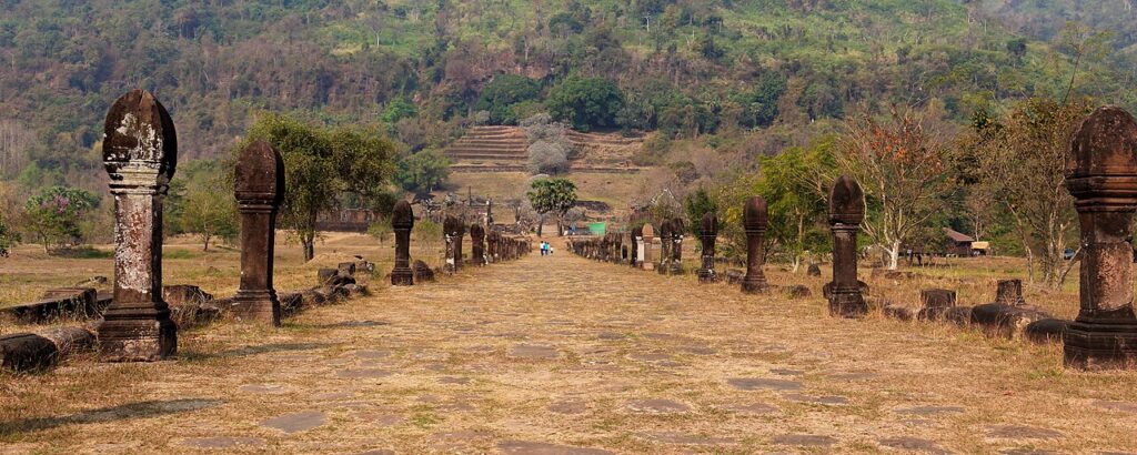
Vat Phou and Associated Ancient Settlements within the Champasak Cultural Landscape (ວັດພູ, “Wat Phu” — “Temple of the Mountain” — also written “Vat Phou” in Lao orthography), inscribed by UNESCO in 2001, is a series of ruined temples and associated archaeological sites distributed across the landscape of Champasak Province in southern Laos — a Khmer-Indianised monument complex centred on the temple of Vat Phou (built on a natural spring-fed terrace 100 metres up the slope of Phou Kao mountain, 6 km from the Mekong River bank) that represents one of the most significant pre-Angkor and early Angkor period religious sites in mainland Southeast Asia, predating the Angkor Empire’s construction of Angkor Wat by several centuries and representing the direct cultural predecessor of the Khmer monument tradition. The Vat Phou site is remarkable for the specific geographical relationship between the mountain, the spring, and the settlement grid: a 6-km processional avenue (called “allee” in the French archaeological literature) connects the main temple on the mountain slope to the two “palaces” (a pair of large Khmer-period buildings, one on each side of the processional avenue, approximately halfway between the Mekong and the mountain, whose function as “palaces” is actually uncertain — they may have been for religious ablutions before the temple approach) and the Mekong riverfront town site — a planned urban landscape of extraordinary scale that was the capital of the pre-Khmer Chenla/Zhenla kingdom (approximately 5th–8th century CE) before the Angkor Empire consolidated power. The central temple sanctuary at Vat Phou is a small but extraordinarily well-preserved Khmer-period stone sanctuary of approximately 1,000 CE (the principal Angkor-period construction, though the site was used from at least the 5th century CE), dedicated to Shiva in the form of a natural spring (the spring water that flows from the mountain cliff behind the sanctuary was identified as the sacred water associated with Shiva’s cosmic mountain, and the ritual washing in this spring water was the primary sacred act of the Vat Phou pilgrimage tradition).
Vat Phou’s mountain temple and the Champasak cultural landscape Vat Phou main temple · Nang Sida temple · Champasak town · Mekong · Pakse — 0 to 40 km
The Champasak cultural landscape designated by UNESCO (which extends approximately 390 km² and includes the Vat Phou temple complex, the two “palace” buildings, the processional avenue, the Mekong riverfront town of ancient Champasak, and several satellite temple sites including Hin Lat Sekha and the Nang Sida temple) represents an ancient sacred geography in which the relationship between the Mekong River, the 6-km processional axis, and the Phou Kao mountain summit (which has a naturally linga-shaped peak visible from the Mekong — the natural mountain form was identified in the Khmer religious tradition as the living embodiment of Shiva’s cosmic linga, making the entire mountain a natural sacred object) constitutes the temple complex’s fundamental spatial logic: the temple of Vat Phou is not simply a building on a mountain slope, but the developed terminus of a sacred landscape that begins at the Mekong and ascends to the mountain spring and the natural linga summit 700 metres above, with the entire landscape being understood as Shiva’s body in the universe. This cosmological landscape organisation — the sacred river, the processional axis, and the mountain at the axis’s end — is broadly analogous to the organisation of Angkor (where the West Baray and the processional causeway across the moat of Angkor Wat lead to the central sanctuary of the cosmic mountain), and Vat Phou has been identified by scholars as one of the earliest expressions of this Khmer sacred landscape type. The Vat Phou festival (Boun Wat Phou, held at the February full moon of the third Lao lunar month) is one of the most significant religious festivals in southern Laos — pilgrims from across the region gather at the site for three days of offerings, music, elephant processions, and the annual buffalo sacrifice at the mountain spring (the buffalo sacrifice at the spring is a pre-Buddhist animist tradition that has been maintained within the Buddhist festival context — one of the most unusual examples of hybrid religious practice in Lao heritage).
Practical information
Vat Phou is approximately 10 km from the town of Champasak and approximately 40 km south of Pakse (the major regional city of southern Laos, in Champasak Province, with a domestic airport and bus connections to Vientiane and to the Thai border crossings at Chong Mek/Phibun Mangsahan). From Pakse: bus to Champasak (approximately 1.5 hours); or hire a bicycle/motorcycle from Pakse and cycle the Mekong road to Champasak (approximately 2–3 hours, scenic). From Champasak town to the Vat Phou entrance: bicycle hire in Champasak (strongly recommended — the site is compact and flat, the 6-km processional avenue is walkable or cycleable). Vat Phou Archaeological Museum (at the site entrance) has displays of Khmer sculpture, inscriptions, and ceramics from the site. Site is open daily 08:00–18:00; admission fee applies. The Don Khong/Si Phan Don (Four Thousand Islands) area of the Mekong River (approximately 90 km south of Pakse) and the Bolaven Plateau (the coffee-producing plateau east of Pakse, famous for its waterfalls and French colonial coffee plantations) are the major complementary attractions in the Champasak Province region. Best visiting months: November–April (dry season, Mekong at low level showing sandbanks). The Boun Wat Phou festival (February full moon) is the peak visitor period — accommodation in Champasak books months in advance.
Frequently Asked Questions
What is the relationship between Vat Phou and the Angkor Empire?
The relationship between Vat Phou and the Angkor Empire is one of the most significant questions in Khmer archaeological scholarship — both because Vat Phou is demonstrably older than Angkor’s classic period and because the specific form of sacred landscape organisation at Vat Phou (river–processional axis–mountain temple) appears to be an influential precedent for the Angkor sacred landscape tradition. The historical documentation for Vat Phou (from Chinese chronicles, Sanskrit inscriptions at the site, and Khmer inscriptions at Angkor that mention Vat Phou) establishes that the site was occupied as a religious centre from at least the 5th century CE (the inscriptions of the early Chenla/Zhenla kingdom mention the Shiva temple at the Phou Kao mountain) and that it was a significant Khmer imperial site from approximately the 9th–13th centuries CE (the principal surviving temple buildings are dated to this Angkor period by their architectural style). The Angkor king Jayavarman VI (1080–1107 CE) was born at Vat Phou and his coronation inscription notes that the site was the sacred origin point of his royal lineage — making Vat Phou the ancestral sacred site of the Mahidharapura dynasty that ruled Angkor from approximately 1080 to 1218 CE (the dynasty that produced Suryavarman II, the builder of Angkor Wat, and Jayavarman VII, the builder of Angkor Thom and the Bayon). This dynastic connection between Vat Phou and the greatest period of Angkor construction — the 12th–13th century CE classical period that produced Angkor Wat and Angkor Thom — gives Vat Phou a specific historical significance as the ancestral homeland of the kings who created the definitive monuments of Khmer civilisation. The sacred landscape model of Vat Phou (mountain linga + spring + river + processional axis) was likely influential in the formation of the Angkor sacred geography model — though the specific mechanism of influence (direct architectural copying, or shared religious conceptual tradition) is debated in Khmer art history scholarship. What is clear is that Vat Phou and Angkor share the same fundamental cosmological programme (representing Shiva’s cosmic mountain in the landscape) expressed through the same basic architectural and spatial vocabulary (temple on mountain or artificial mountain, processional water crossing, axial approach), and that Vat Phou chronologically precedes the Angkor classical period by several centuries.
What are the associated ancient settlements of the Champasak cultural landscape and why are they included in the UNESCO designation?
The “associated ancient settlements” component of the UNESCO World Heritage inscription of Vat Phou and Associated Ancient Settlements (the full name of the inscribed property) refers to a series of archaeological sites distributed across the Champasak cultural landscape beyond the main Vat Phou temple complex — sites that, taken together, document the full extent of the pre-Angkor and Angkor-period urban and religious landscape of the Champasak region. The most significant associated sites are: (1) the ancient town site of Champasak (the “lower town” at the Mekong riverfront, approximately 6 km south of the Vat Phou processional axis — the remains of the pre-Angkor Zhenla/Chenla capital that was the major urban centre of the Champasak region, archaeologically dated to approximately 5th–8th century CE, now overlaid by the modern Champasak town); (2) the two “palace” buildings on the central processional avenue (the pair of laterite and sandstone buildings approximately 3 km from the Mekong and 3 km from the mountain temple — their formal classification as “palaces” in the original French archaeological survey of the 1930s CE is now questioned; current scholarship suggests they may have been salas [rest halls] or ablution buildings for pilgrims approaching the mountain temple); (3) the Nang Sida temple (a subsidiary Khmer-period temple approximately 1 km north of the main Vat Phou temple complex, dedicated to Nang Sida — Sita, the consort of Rama in the Hindu Ramayana epic, connecting the Champasak religious complex to the Vaishnava tradition alongside the primary Shaivite/Shiva tradition of Vat Phou); (4) the Hin Lat Sekha site (an early pre-Angkor shrine incorporating natural rock formations approximately 2 km from the Vat Phou main temple, representing the earliest phase of the site’s use before formal architectural construction). The designation of these associated sites within the overall “cultural landscape” property type (rather than a “monument” property type) reflects the UNESCO World Heritage Committee’s recognition that the outstanding universal value of Vat Phou rests on the entire landscape system — the spatial relationship between river, avenue, temple, and mountain — rather than on any single building or group of buildings. This landscape-scale property type was innovative at the time of inscription (2001) and has influenced subsequent UNESCO inscriptions that use the “cultural landscape” category for sites where the relationship between human heritage and natural geography is the primary value.
EXCERPT: Vat Phou and Associated Ancient Settlements, UNESCO-inscribed 2001, is the 5th–13th century Khmer mountain temple complex in Champasak, Laos — a 6-km processional avenue from the Mekong to a sacred mountain spring where Shiva’s water still flows, the ancestral homeland of the Angkor kings who built Angkor Wat, and the February Boun Wat Phou full-moon festival with elephant procession.
META: UNESCO World Heritage Sites near Vat Phou Laos: Town of Luang Prabang 550 km north (UNESCO 1995), Plain of Jars 400 km north (UNESCO 2019), Angkor Archaeological Park Cambodia (UNESCO 1992) — Vat Phou Champasak Laos UNESCO 2001, Khmer Chenla sacred landscape Mekong mountain, Phou Kao linga Shiva temple, Pakse Champasak Province southern Laos, Boun Wat Phou festival.
Sources
- S1 — UNESCO World Heritage Centre — Vat Phou and Associated Ancient Settlements within the Champasak Cultural Landscape (Ref. 481) — https://web.archive.org/web/20230601000000/https://whc.unesco.org/en/list/481/
- S2 — UNESCO World Heritage Centre — Statement of Outstanding Universal Value (Ref. 481) — https://whc.unesco.org/en/list/481/
Spotted an error? Write to the editors and we correct it the same day.