
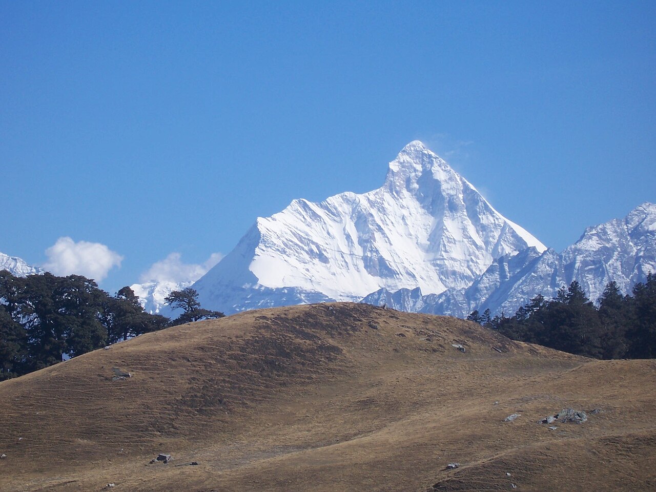
Nanda Devi and Valley of Flowers National Parks (नंदा देवी और फूलों की घाटी राष्ट्रीय उद्यान), inscribed by UNESCO in 1988 (Nanda Devi National Park) and extended in 2005 (Valley of Flowers National Park), is a biosphere reserve complex in the Garhwal Himalayas of Uttarakhand, India — centred on the Nanda Devi Peak (7,816 m, the second highest mountain entirely within India after Kangchenjunga, and the 23rd highest mountain in the world; the highest mountain in British India before the Great Trigonometric Survey measurements in the 1850s identified Kangchenjunga and Everest as higher), a mountain of extraordinary sacred significance in the Hindu and Garhwali traditions (Nanda Devi, “Bliss-Giving Goddess”, is the presiding deity of Garhwal and Kumaon and the central figure of the Nanda Devi Raj Jat Yatra pilgrimage, conducted every 12 years — the next is scheduled for approximately 2026 CE). The Nanda Devi National Park (approximately 624 km² of the inner sanctuary, the high-altitude core zone from approximately 3,500 m to 7,816 m including the entire Nanda Devi Sanctuary, the high-altitude basin enclosed by the Nanda Devi ring of satellite peaks through which the Rishi Ganga gorge is the only entry) and the Valley of Flowers National Park (approximately 87 km², in the Bhyundar Valley at approximately 3,352 m to 6,675 m altitude, approximately 35 km from the Nanda Devi Sanctuary access) together form an Outstanding Universal Value in Himalayan biodiversity — the inner Nanda Devi Sanctuary is one of the most strictly protected areas in India (closed to all visitors since 1982, when the pressures of mountaineering and trekking activity were identified as causing irreversible damage to the fragile high-altitude ecosystem) and the Valley of Flowers is the most accessible high-altitude flower meadow in the Himalayan region, accessible on foot from Govindghat (accessible by road from Joshimath) via a 14 km trek to Ghangaria.
Nanda Devi’s Himalayan sanctuary and the Garhwal alpine heritage corridor Valley of Flowers · Ghangaria · Hemkund Sahib · Badrinath · Joshimath — 0 to 45 km
The Valley of Flowers (Bhyundar Valley) is the accessible component of the UNESCO inscription for the general visitor — the inner Nanda Devi Sanctuary, while more spectacular, is closed to all tourism and only occasionally opened for scientific research expeditions with Forest Department permission. The valley (a U-shaped glacially carved valley at 3,352–3,658 m altitude, approximately 5 km long and 2 km wide, accessed via the 14 km trek from Govindghat through Ghangaria) transforms from barren rock and snow in May to a carpet of alpine meadow flowers in June–September following the monsoon onset: approximately 300–500 species of flowering plants bloom in succession through the monsoon season, including Himalayan blue poppy (Meconopsis aculeata), cobra lily (Arisaema tortuosum), Himalayan balsam (Impatiens), orchids (Dactylorhiza hatagirea, the marsh orchid found here and in high-altitude wet meadows across the Himalayas), and the Brahma Kamal (Saussurea obvallata, the sacred lotus of the Himalayas, the state flower of Uttarakhand and the flower traditionally offered at Badrinath Temple — blooming in August at approximately 4,200–4,500 m and producing a fragrance at night that has made it the object of specific pilgrimage). The Valley of Flowers was “discovered” for the Western botanical world by the British mountaineer Frank Smythe, who stumbled into the valley during the 1931 Kamet Expedition descent and subsequently returned to spend an entire summer botanising, publishing his book “The Valley of Flowers” in 1938 — though the valley had been known to local Garhwali shepherds and pilgrims as Bhyundar Valley for centuries before Smythe’s visit. Hemkund Sahib (approximately 6 km from Ghangaria, at 4,329 m altitude — the highest Sikh gurudwara in the world, on the shores of a glacial lake, with a significance in Sikh theology as the site described in the Sri Dasam Granth where Guru Gobind Singh meditated in a previous life) receives approximately 200,000 Sikh pilgrims per year on the same trekking route as the Valley of Flowers — the two sites share a base at Ghangaria, creating an unusual convergence of ecological tourism and religious pilgrimage on the same mountain trail.
Badrinath (approximately 45 km east of Joshimath on the Alaknanda River, at 3,133 m altitude) is the closest major pilgrimage site of the Hindu tradition to the Nanda Devi-Valley of Flowers complex — one of the four dhams (sacred abodes) of the Char Dham pilgrimage circuit, the Badrinath Temple dedicated to Vishnu in the form of Badrinarayan, receiving approximately 1–1.5 million pilgrims per year in the May–October season. Joshimath (the base town for both Badrinath pilgrimage and the Valley of Flowers trek, on NH 58, approximately 250 km from Haridwar by road) became internationally significant in 2023 when the town’s foundations were found to be sinking at accelerating rates (approximately 5–8 cm per day subsidence during the crisis period of January 2023) due to construction of a hydropower tunnel beneath the town — a stark illustration of the development-heritage-environment tensions in the Garhwal Himalayan region.
Practical information
The Valley of Flowers National Park is open to visitors June 1 to October 31 (monsoon season, when the flowers are in bloom; closed off-season). Access from Haridwar or Rishikesh (approximately 250 km to Joshimath by road on NH 58, approximately 8–10 hours by car; or from Dehradun which has the nearest airport). From Joshimath: 25 km by road to Govindghat, then 14 km trek to Ghangaria (the base camp for both Valley of Flowers and Hemkund Sahib, at approximately 3,048 m). The trek from Govindghat to Ghangaria takes approximately 5–6 hours (moderate to strenuous grade). From Ghangaria: 4 km trek uphill to the Valley of Flowers entrance (approximately 2 hours). The Valley of Flowers has a Forest Department entry gate with admission fees (separate from the trek). Permits are required from the Forest Department of Uttarakhand (Nanda Devi Biosphere Reserve office). Accommodation at Ghangaria: Forest Department rest house and private guesthouses (advance booking essential for July–August peak season). Photography is permitted throughout. The inner Nanda Devi Sanctuary: fully closed to tourism since 1982; only occasional scientific expeditions are granted permits. Best visiting period: late July–mid-August for the maximum flower diversity; September for the autumn wildflower phase. The trek requires reasonable physical fitness (approximately 1,000 m altitude gain from Govindghat to Ghangaria); altitude sickness precautions are advisable.
Frequently Asked Questions
Why was the Nanda Devi Sanctuary closed to mountaineering and trekking in 1982 and what happened after closure?
The Nanda Devi Sanctuary (the high-altitude basin enclosed by the Nanda Devi ring, accessible only through the Rishi Ganga gorge — the approach used by the first ascent team, Eric Shipton and H.W. Tilman, in 1934 CE) was one of the most sought-after mountaineering destinations in the Himalayas from the 1930s to the late 1970s: the first ascent of Nanda Devi (7,816 m) was made by a British-American team (H.W. Tilman and Noel Odell) in 1936, which was at that time the highest peak ever climbed (a record that held until the first ascent of Annapurna in 1950). The sanctuary received dozens of mountaineering expeditions from the 1950s to 1970s, and trekking to the sanctuary floor (approximately 3,500 m to 4,500 m altitude) became increasingly popular in the 1970s following the development of commercial trekking in the Garhwal Himalayas. The cumulative impact of mountaineering and trekking activity on the sanctuary’s fragile high-altitude ecosystem — particularly the harvesting of firewood (the sanctuary’s alpine forest was largely eliminated for fuel by successive expedition camps by the late 1970s), the accumulation of expedition waste, and the trampling of the alpine meadows — led the Indian government to close the sanctuary to all mountaineering and trekking in 1982 (the specific trigger was the damage documented by scientific surveys and the report of the Nanda Devi Himalayan Ecology Project commissioned by the Indian government in 1979). The 1982 closure has remained in effect (with only minor exceptions for specific scientific research expeditions with government permits) for over 40 years. The ecological recovery within the sanctuary following closure has been substantial: the brown bear population (Ursus arctos isabellinus) has increased, the bharal (blue sheep, Pseudois nayaur) and Himalayan musk deer populations have recovered, the snow leopard (Panthera uncia) population within the sanctuary is estimated at 3–5 individuals by camera trap surveys conducted by the Wildlife Institute of India in the 2010s, and the alpine meadow vegetation has regenerated significantly in the areas most heavily damaged by expedition camping. The closure of Nanda Devi was a historically early case (1982) of a protected area recognising that the primary threat to its Outstanding Universal Value was not conventional development or poaching but the weight of visitation itself — a recognition that the UNESCO World Heritage framework for Natural sites has increasingly incorporated in subsequent decades. The parallel UNESCO inscription (the outer buffer zone became accessible to trekking and the Valley of Flowers was incorporated in the 2005 extension as a more accessible component of the UNESCO site) represents the management solution: channelling visitor demand to the more resilient outer landscape while protecting the inner sanctuary absolutely.
What is the sacred significance of Nanda Devi in the Garhwali Hindu tradition?
Nanda Devi (Sanskrit: “Bliss-Giving Goddess”, नन्दादेवी) is the principal deity of the Garhwal and Kumaon Himalayan regions of Uttarakhand — the presiding goddess of the Garhwali and Kumaoni people, worshipped as the daughter of the Himalayan king (a manifestation of Parvati, the consort of Shiva, in her aspect as the “daughter of the mountains”) and associated with the protection of the mountain communities who have lived in the shadow of the peak for millennia. The peak’s sacredness is not reducible to a single myth or text but is embedded in the collective religious identity of the Garhwali-Kumaoni mountain cultures: every village in the Garhwal and Kumaon hills has a Nanda Devi shrine, the goddess is the recipient of daily worship and seasonal festivals across the Kumaon-Garhwal region, and the annual pilgrimage to Nanda Devi shrines (at various altitudes from the foothills to the high-altitude glaciers) is a central feature of mountain community life. The Nanda Devi Raj Jat Yatra (नंदा देवी राज जात यात्रा, “Grand Pilgrimage of the Bliss-Giving Goddess”) — conducted every 12 years — is one of the most extraordinary religious events in Himalayan India: a 280 km pilgrimage on foot through the Garhwal and Kumaon Himalayas over approximately 19 days, starting from Nauti village (near Karnprayag) and traversing progressively higher altitudes to the Roopkund Lake (at approximately 5,029 m) and then to the Homkund glacier (at approximately 4,800 m below the Trishul massif, approximately 12 km from the Nanda Devi outer sanctuary), where the final ritual of sending a four-horned ram (chamdiya, a naturally occurring tetrahedral-horned sheep considered a divine messenger) alone into the high glacier as an offering to Nanda Devi marks the conclusion of the pilgrimage. The 2000 CE Raj Jat Yatra attracted approximately 150,000 pilgrims; the 2012 CE yatra was postponed due to flash floods; the scheduled 2024 yatra has been confirmed. The Yatra’s route passes through areas of outstanding natural beauty in the Garhwal-Kumaon Himalayan landscape, and the pilgrimage crowd itself — a moving mass of mountain community members in traditional dress — is one of the great human spectacles of the Himalayas. The UNESCO inscription acknowledges the spiritual values associated with Nanda Devi as part of the Outstanding Universal Value of the site: the inscription text notes that the Nanda Devi sanctuary is a place of outstanding natural beauty and of profound cultural significance to the mountain communities of the region, and that the sacred status of the mountain has itself contributed to its conservation over centuries.
EXCERPT: Nanda Devi and Valley of Flowers National Parks, UNESCO-inscribed in 1988 and 2005, encompasses India’s highest sacred peak (7,816 m, closed to mountaineering since 1982 for ecosystem recovery) and the Valley of Flowers (300–500 Himalayan wildflower species in monsoon bloom at 3,352 m), with Hemkund Sahib, the world’s highest Sikh gurudwara, sharing the same trekking route.
META: UNESCO World Heritage Sites near Nanda Devi and Valley of Flowers Uttarakhand India: Great Himalayan National Park 200 km northwest (UNESCO 2014), Khangchendzonga National Park 500 km east (UNESCO 2016) — Uttarakhand Garhwal Himalayas UNESCO heritage, Nanda Devi sacred peak pilgrimage, Valley of Flowers trekking Bhyundar Valley alpine meadows.
Sources
- S1 — UNESCO World Heritage Centre — Nanda Devi and Valley of Flowers National Parks (Ref. 335) — https://web.archive.org/web/20230601000000/https://whc.unesco.org/en/list/335/
- S2 — UNESCO World Heritage Centre — Statement of Outstanding Universal Value (Ref. 335) — https://whc.unesco.org/en/list/335/
Spotted an error? Write to [email protected] and we correct it the same day.