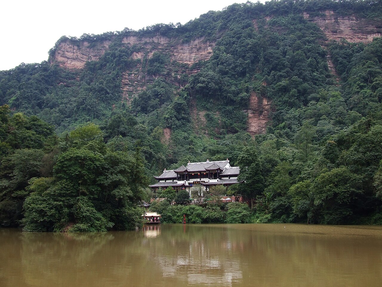
Mount Qingcheng and the Dujiangyan Irrigation System, inscribed together by UNESCO in 2000, represent two distinct but complementary aspects of Sichuan Province’s cultural heritage: Mount Qingcheng (Qingcheng Shan, “Green City Mountain”), a 1,260-metre forested Daoist sacred mountain 65 kilometres northwest of Chengdu whose 36 peaks form the circular outline that gives it its name, and the Dujiangyan Irrigation System, the world’s oldest large-scale hydraulic engineering project in continuous operation, built 256 BCE by the Qin engineer Li Bing on the Minjiang River 3 kilometres southeast of Mount Qingcheng. Mount Qingcheng is regarded as the birthplace of Daoism in China: the Later Han dynasty Daoist master Zhang Daoling (34–156 CE), who founded the Celestial Masters (Tianshi Dao) sect — the first institutionalised Daoist religious organisation in Chinese history — established his community on Mount Qingcheng circa 143 CE, and the mountain has been a continuously inhabited Daoist site since that date. The Dujiangyan system — consisting of three interlinked components (the Yuzui fish-snout levee that divides the Minjiang into inner and outer channels, the Feishayan overflow spillway that regulates flood management, and the Baopingkou bottle-neck intake that controls irrigation flow) — has been irrigating the Chengdu Plain continuously for 2,276 years without a dam and without dredging the river bed, making it the only ancient large-scale irrigation system still functioning by its original engineering principles.
The Chengdu Plain and the upper Yangtze headwaters Jiuzhaigou Valley · Huanglong · Dazu Rock Carvings — 200 to 350 km
Two hundred twenty kilometres north of Mount Qingcheng and Dujiangyan by road (approximately 3.5 hours from Dujiangyan City via the G5 Chengdu-Lhasa Expressway north through Songpan to the Jiuzhaigou Valley entrance), the Jiuzhaigou Valley (inscribed 1992) in Aba Tibetan and Qiang Autonomous Prefecture is the most visited natural UNESCO site in Sichuan — a 720-square-kilometre protected valley of multi-tiered waterfalls, transparent turquoise lakes, and dead conifer forests preserved underwater in the mineral-rich water. The connection between Jiuzhaigou’s natural landscape and the Dujiangyan irrigation system is the Minjiang River: Jiuzhaigou’s waters drain south through the Minshan Mountains into the upper Minjiang tributary system, ultimately reaching the same Minjiang that the Dujiangyan system diverts onto the Chengdu Plain. The Tibetan and Qiang Autonomous Prefecture context of Jiuzhaigou also connects to the Daoist tradition at Qingcheng: the pre-Daoist animist mountain belief systems of the Tibetan and Qiang indigenous cultures of the Aba region were partially absorbed into the early Daoist tradition that Zhang Daoling systematised at Qingcheng — the Wudu (Sorcery Ban) tradition that Zhang Daoling formulated as an ethical code explicitly prohibited the shamanistic practices of the indigenous mountain cultures while preserving the mountain-spirit conceptual landscape that those practices assumed. From Dujiangyan City, Jiuzhaigou is reached by road via the G5 north (approximately 3.5 hours) or by flight from Chengdu Shuangliu Airport to Jiuzhaigou-Huanglong Airport (1 hour).
Two hundred fifty kilometres north of Mount Qingcheng by road (approximately 4 hours from Dujiangyan City via Songpan and the S301 to the Huanglong Valley entrance), the Huanglong Scenic and Historic Interest Area (inscribed 1992) is the companion natural inscription to Jiuzhaigou in the same Aba Prefecture mountain zone — a 700-square-kilometre valley of travertine calcium-carbonate pool terraces at 3,400–5,588 metres altitude, combined with the Xuebaoding Peak (5,588 metres, the highest point in all of Sichuan Province’s northern highlands) and the Mounigou Valley karst landscape. Huanglong’s Daoist and folk religious associations — the Huanglong Gong (Yellow Dragon Palace) temple complex at the valley’s upper end, dedicated to the Yellow Dragon deity (a Daoist water-spirit associated with the beneficial irrigation waters of the Minjiang system) — directly connect the mountain’s sacred landscape to the Dujiangyan system’s engineering. The Yellow Dragon is the mythological patron of the Minjiang River basin: the folk tradition holds that Li Bing, the Qin engineer who built Dujiangyan, subdued a water-dragon spirit in the Minjiang River before the irrigation system’s construction (the dragon-subduing legend is the most widely known folk explanation for Dujiangyan’s hydraulic engineering success). From Dujiangyan, Huanglong is reached via the same G5 route as Jiuzhaigou (Huanglong’s entrance is approximately 50 km before Jiuzhaigou on the same road, approximately 3.5 hours from Dujiangyan).
Three hundred kilometres southeast of Mount Qingcheng by high-speed rail (approximately 1.5 hours from Chengdu East to Dazu East on the Chengdu-Chongqing HSR Intercity, then 25 minutes by shuttle to Baodingshan), the Dazu Rock Carvings (inscribed 1999) in Dazu County, Chongqing Municipality, are the other major cultural inscription of the Sichuan-Chongqing basin. The connection between Dazu’s Tang-Song Buddhist carving tradition and the Qingcheng Daoist tradition is the same Sichuan Basin popular religion context: both are products of the religious landscape of the Chengdu Plain and its surrounding highlands, where Buddhist, Daoist, and indigenous spirit-worship traditions competed for popular devotion from the Han dynasty onward. The Celestial Masters (Tianshi Dao) sect that Zhang Daoling founded at Qingcheng in the 2nd century CE was the major religious institution of the Sichuan Basin in the Han-Three Kingdoms period; the Tang-Song Buddhist tide that produced the Dazu carvings in the 9th–13th centuries had to engage with an already mature Daoist institutional tradition in Sichuan whose geographic centre was Qingcheng. Several of the Dazu carvings explicitly depict Daoist practitioners in scenes of Buddhist instruction — the competition between the two traditions is directly documented in the cliff-face narratives. From Chengdu (Chengdu East Station), Dazu is reached by HSR (approximately 1.5 hours) and then shuttle (25 minutes).
Sixty kilometres northeast of Mount Qingcheng, within the Chengdu metropolitan area by metro and high-speed rail (approximately 45 minutes from Dujiangyan City to Chengdu People’s Park area on Line 6 subway), the Jinsha Site Museum documents the pre-Qin Bronze Age Shu culture of the Chengdu Plain — the same civilisation that the Dujiangyan irrigation system ultimately replaced and transformed. The Jinsha site (discovered 2001, museum opened 2007) contains the remains of a large Shu Bronze Age settlement dated to approximately 1200–650 BCE — the period of the Sanxingdui culture’s final phase before the Qin conquest of Shu in 316 BCE. The most iconic Jinsha artefact is the “Sun and Immortal Birds” (太阳神鸟) gold foil disc (outer diameter 12.5 cm, inner disc 5 cm, cut to represent a rotating solar disc with a surrounding ring of four stylised birds) — the emblem of Chengdu city and the logo of the Chinese Cultural Heritage Administration. The Jinsha culture’s sophisticated bronze-casting and gold-working tradition preceded both the Dujiangyan irrigation system (256 BCE) and the Qingcheng Daoist tradition (143 CE), and provides the deep pre-Han archaeological context for understanding the Sichuan Basin’s cultural sequence: Sanxingdui-Jinsha Bronze Age (1700–650 BCE) → Shu Kingdom conquest (316 BCE) → Dujiangyan engineering and agricultural transformation (256 BCE) → Han-period Daoist systematisation at Qingcheng (143 CE) → Tang-Song Buddhist carving at Dazu (late 9th to 13th centuries). From Dujiangyan City, the Jinsha Site Museum is accessible by metro Line 6 to Kehua North Road and then Line 5 to Jinsha Museum (approximately 1.5 hours).
West toward the Tibetan Plateau and south along the Sichuan heritage corridor Huanglong · Chengdu urban heritage · Mount Emei Leshan — 100 to 200 km
One hundred fifty kilometres south of Mount Qingcheng and Dujiangyan by high-speed rail (approximately 1 hour from Chengdu East to Emeishan Station on the Chengdu-Kunming HSR), the Mount Emei Scenic Area and the Leshan Giant Buddha (inscribed together 1996) are the other major Sichuan cultural-natural UNESCO inscription and the most frequently combined with Qingcheng and Dujiangyan in regional touring circuits. Mount Emei (3,099 metres) is one of the Four Sacred Buddhist Mountains of China and houses 30 active Buddhist temples and monasteries at various elevations from the mountain base to the Golden Summit (Jinding, 3,077 metres), accessible by a combination of cable car and hiking trails. The Golden Summit temple at Emei is the home of Puxian Bodhisattva (Samantabhadra) — the bodhisattva of universal virtue — and the morning cloud-sea phenomenon (foggy dawn light below the summit creating a “sea of clouds” broken by the individual peaks) is the most celebrated natural spectacle in the Sichuan Buddhist mountain tradition. The Leshan Giant Buddha (71 metres tall, carved from the cliff face between the confluence of the Minjiang, Dadu, and Qingyi rivers, construction 713–803 CE) — the world’s largest surviving pre-modern stone Buddha statue — is located 30 kilometres downstream from Emei, accessible by boat from the Leshan dock area. The Leshan Buddha was carved by the monk Haitong to protect river traffic from the dangerous confluence currents: the excavated rock debris that was thrown into the river during the carving process altered the riverbed hydrodynamics sufficiently to reduce the worst turbulence — a side-effect that reinforced the Buddha’s miraculous protective reputation. From Dujiangyan, Emei is reached by metro to Chengdu East and HSR south (approximately 1.5 hours).
Two hundred kilometres west of Mount Qingcheng by road (approximately 2.5 hours from Dujiangyan City via the Ya’an road toward Kangding, then southwest on the S2), the Siguniangshan (Four Girls Mountain) area in Xiaojin County — a 4,295-square-kilometre protected area of glaciated peaks (the highest, Siguniangshan itself, at 6,250 metres) and Qiangic minority culture villages — is on China’s UNESCO Tentative List as part of the Sichuan Giant Panda Sanctuaries application (the Giant Panda Sanctuaries at Wolong, Siguniang and Jiajin Mountains are inscribed 2006). The Sichuan Giant Panda Sanctuaries inscription (inscribed 2006) — covering seven nature reserves and nine scenic parks across 924,500 hectares of Sichuan’s highland zone, including the Qionglai and Jiajin mountain ranges west and southwest of Chengdu — is the largest protected area network for the giant panda (Ailuropoda melanoleuca) and its habitat: approximately 30% of the world’s wild giant panda population lives within the inscription’s boundaries. The Wolong National Nature Reserve component (approximately 200,000 hectares, 100 km southwest of Chengdu) is the most accessible panda habitat for visitors; the China Conservation and Research Center for the Giant Panda at Hetaoping within Wolong is the primary facility where captive-bred pandas are prepared for wild release. From Dujiangyan, Wolong is accessible by road via Yingxiu (approximately 2 hours); from Chengdu, approximately 2.5 hours. The 2008 Wenchuan earthquake epicentre (7.9 magnitude, approximately 50,000 deaths) was within the Wolong reserve boundary; the reserve’s visitor infrastructure was rebuilt 2008–2012.
One hundred kilometres north of Mount Qingcheng by road (approximately 1.5 hours from Dujiangyan City to the Qingcheng Back Mountain entrance area, continuing north to the Longmen Shan area in Anxian County), the Longmen Shan fault zone — the surface expression of the geological boundary between the Sichuan Basin and the Tibetan Plateau — provides the most immediately visible geological context for the two inscriptions. The Longmen Shan fault (the same fault system that produced the 2008 Wenchuan earthquake) runs northeast-southwest approximately 20 kilometres west of Dujiangyan City, with the Minjiang River (which the Dujiangyan system diverts) descending from the fault’s upthrown Tibetan Plateau side through the mountains to the Chengdu Plain. The Dujiangyan system’s engineering genius — recognising that the Minjiang’s variable flow between flood season (glacial melt plus monsoon rain, June–September) and dry season (glacial minimum, November–March) could be managed through flow division rather than storage — was an engineering response to the same geological gradient that the Longmen Shan fault creates: the river descends 3,500 metres in 100 kilometres from its Tibetan source, creating the hydraulic energy and sediment load that the Dujiangyan’s Yuzui levee and Feishayan spillway manage without a dam. From Dujiangyan, the fault scarp is visible to the northwest from the Erwang Temple viewpoint above the Yuzui levee head.
Practical information
Mount Qingcheng and the Dujiangyan Irrigation System are in Dujiangyan City, Chengdu, approximately 65 kilometres northwest of central Chengdu. Subway access: Chengdu Metro Line 6 connects Chengdu city centre to Dujiangyan (Dujiangyan Station), approximately 45 minutes from People’s Square. High-speed rail connects Chengdu East to Qingcheng Mountain Station (approximately 30 minutes). From Chengdu Shuangliu Airport, the route is Airport Line to Shuangliu Airport Station, then Line 6 to Dujiangyan (approximately 1.5 hours). The Dujiangyan irrigation system’s primary visitor area centres on the Erwang Temple (Temple of the Two Kings, dedicated to Li Bing and his son) on the hill above the Yuzui levee head, the Anlan suspension footbridge crossing the inner/outer channel split point, and the fish-mouth levee walkway — from which the engineering’s three-component logic (divider, spillway, intake) is visible simultaneously. The Mount Qingcheng visitor site has two sections: Qingcheng Front Mountain (Qian Shan, the historical Daoist area with the Tianshi Cave and the upper cable car to the summit lake area, approximately 3–4 hours round trip on foot or 1.5 hours via cable car) and Qingcheng Back Mountain (Hou Shan, the wilder area with waterfalls and fewer crowds, approximately 5 hours round trip). The Tianshi Cave (Tianshi Dong) on Qingcheng Front Mountain is the site where Zhang Daoling is said to have established his Celestial Masters community in 143 CE and remains an active Daoist religious site. Both the Dujiangyan system and Mount Qingcheng are best visited in one combined day from Chengdu; early arrival (7:00 AM at Dujiangyan, 8:00 AM at Qingcheng) avoids midday crowds. The area is approximately 100 km from the 2008 Wenchuan earthquake epicentre; most structures were rebuilt by 2012 and the cultural heritage sites sustained less damage than the surrounding residential buildings.
Frequently Asked Questions
How does the Dujiangyan Irrigation System work and why has it survived for 2,300 years without a dam?
The Dujiangyan Irrigation System operates through three interlinked engineering components that work together to divide, regulate, and distribute the Minjiang River’s flow without blocking it with a dam. The first component is the Yuzui (“fish snout”) Levee — a banana-shaped earthen and stone dike built on a gravel island in the middle of the Minjiang River that divides the river into an Inner Channel (Neijiang, approximately 40% of the flow, directed onto the irrigation canals) and an Outer Channel (Waijiang, approximately 60% of the flow, continuing down the original riverbed). The Yuzui Levee’s curvature and position are designed so that the river’s natural laminar flow dynamics (slower, cleaner water near the inner bank in summer; faster, siltier water in the outer channel in summer) automatically direct the high-season irrigation flow inward without human intervention. The second component, the Feishayan (“flying sand weir”) Overflow Spillway, is a low stone wall at the point where the inner channel curves toward the intake, calibrated to overflow into the outer channel when the inner channel’s water level exceeds a set height — acting as an automatic flood gate that prevents the irrigation system from flooding the Chengdu Plain in high-monsoon years. The third component, the Baopingkou (“bottle neck intake”), is a 20-metre-wide gap cut through a rocky ridge that constricts the inner channel’s flow and distributes it into the irrigation canal network at a controlled rate regardless of seasonal variation. The system’s 2,300-year survival is explained by annual maintenance: the Qin-period engineers calculated that the Yuzui Levee required annual lowering (in winter) to clear sediment from the inner channel and annual raising (in spring) before flood season — a maintenance protocol that has been performed every year since 256 BCE, making Dujiangyan a continuously maintained engineering infrastructure rather than a passive monument.
Who was Zhang Daoling and why is Mount Qingcheng regarded as the birthplace of Daoism?
Zhang Daoling (张道陵, 34–156 CE, also called Zhang Ling or the Heavenly Master Zhang) was a Later Han dynasty religious teacher who founded the Celestial Masters (Tianshi Dao, 天师道) on Mount Qingcheng circa 143 CE — the first institutionalised Daoist religious organisation in Chinese history, with a structured community, a moral code (the Wudu, “five pecks of rice” requirement for community members), initiation rituals, and a hierarchy of religious authority based on the transmission of sacred registers (lu, 箓). Zhang Daoling claimed to have received a revelation from the deified Laozi (the author of the Daode Jing, regarded as the founding text of Daoist philosophy) instructing him to establish a new moral order; the Celestial Masters tradition regards this revelation as the beginning of Daoism as a religion (Daojiao) distinct from Daoist philosophy (Daoxue). The claim that Mount Qingcheng is the “birthplace of Daoism” refers specifically to this institutional founding moment — the establishment of a community, a hierarchy, and a systematic practice rather than the composition of the Daode Jing itself (which predates Zhang Daoling by approximately 400 years and was not associated with a particular mountain). Qingcheng’s role was not accidental: the mountain’s existing reputation as a sacred forest landscape (Qingcheng means “Green City,” referring to the mountain’s characteristic of being so densely forested that its peaks form a circular canopy resembling a city wall from a distance) made it an appropriate site for the Daoist community’s emphasis on natural landscape as the site of spiritual cultivation. Zhang Daoling’s grandson Zhang Lu (张鲁) established the Celestial Masters as a theocratic state governing the Hanzhong region of Sichuan and southern Shaanxi from 189 to 215 CE — the first Daoist-governed polity in Chinese history — before surrendering to the warlord Cao Cao, who transported the Celestial Masters community to northern China and ended the Sichuan Daoist state.
What is the significance of Li Bing’s engineering achievement at Dujiangyan in the context of world hydraulic history?
Li Bing (李冰, active 256–251 BCE) was appointed Governor of Shu by the Qin King Zhaoxiang (r. 306–251 BCE) and directed the construction of the Dujiangyan system as part of the Qin state’s strategy for consolidating control of the Sichuan Basin by making the Chengdu Plain reliably productive — the agricultural surplus of a properly irrigated Chengdu Plain would supply the Qin military campaigns that eventually unified China under the First Emperor (221 BCE). The Dujiangyan engineering is significant in world hydraulic history for three reasons. First, it is the only large-scale pre-modern irrigation system still functioning by its original engineering principles: Egypt’s Nile irrigation, Mesopotamia’s Tigris-Euphrates canals, and Rome’s aqueducts are all non-operational historical monuments; Dujiangyan still irrigates approximately 670,000 hectares of Sichuan farmland through a canal network that, while expanded in the 20th century, still uses the original Yuzui, Feishayan, and Baopingkou components as its upstream regulatory elements. Second, the system’s design principle — flow division rather than flow blockage — is a fundamentally different hydraulic approach from the dam-based irrigation systems that dominated the ancient Near East and remain the dominant model in modern large-scale irrigation engineering. The dam-based approach stores water by blocking flow and releases it in controlled amounts; the Dujiangyan approach maintains flow and divides it, using the river’s own hydrodynamic properties to separate inner (clean, slower, irrigation-quality) from outer (siltier, faster, flood-discharge) flow. Third, the system’s maintenance requirement — annual winter drawdown, sediment clearance, and spring recommissioning — demonstrates that Li Bing understood the system’s long-term stability as dependent on human engagement rather than structural permanence: a dam fails catastrophically when breached, while a flow-division system degrades gradually and can be annually corrected by the same engineering knowledge that built it.
Sources
- S1 — UNESCO World Heritage Centre — Mount Qingcheng and the Dujiangyan Irrigation System (Ref. 1001) — https://web.archive.org/web/20230601000000/https://whc.unesco.org/en/list/1001/
- S2 — UNESCO World Heritage Centre — Statement of Outstanding Universal Value (Ref. 1001) — https://whc.unesco.org/en/list/1001/
Spotted an error? Write to editorial@culturalheritageonline.com and we correct it the same day.